Posh grave of Iron Age ‘warrior’ buried 2,000 years ago in Roman Britain uncovered
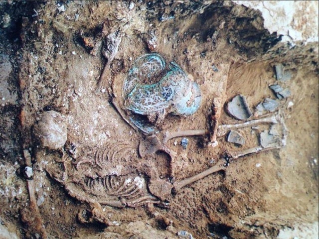
UCL archaeologists have uncovered a richly furnished grave belonging to an Iron Age ‘ warrior ‘ found 2,000 years ago in West Sussex.
Iron Age warrior grave excavated in West Sussex
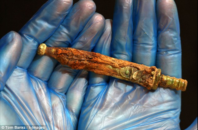
In the grave were placed iron weapons, including a sword in a highly decorated scabbard and a spear. The burial was discovered during an excavation commissioned by Linden Homes, who are developing a site on the outskirts of Walberton, near Chichester, to create 175 new homes.
The team that made the discovery were from Archaeology South-East (ASE), the commercial branch of UCL’s Institute of Archaeology.
ASE archaeologist Jim Stevenson, who is managing the post-excavation investigations into the burial, said: “There has been much discussion generally as to who the people buried in the ‘warrior’ tradition may have been in life.
Were they really warriors, or just buried with the trappings of one?
Sword midway through conservation and its X-rays
“Although the soil conditions destroyed the skeleton, the items discovered within the grave suggest that the occupant had been an important individual.”
The grave is dated to the late Iron Age/ early Roman period (1st century BC – AD 50). It is incredibly rare, as only a handful are known to exist in the South of England.
X-rays and initial conservation of the sword and scabbard reveal beautiful copper-alloy decoration at the scabbard mouth, which would have been highly visible when the sword was worn in life.
Dotted lines on the X-ray may be the remains of a studded garment worn by the occupant when buried. This is particularly exciting for archaeologists as evidence of clothing rarely survives.
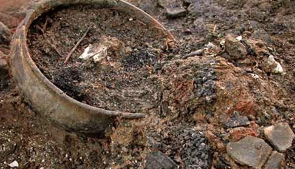
Ceramic jar found in the grave
The grave also held the remains of a wooden container, preserved as a dark stain, likely used to lower the individual into the grave.
Four ceramic vessels were placed outside of this container, but still within the grave. The vessels are jars made from local clays and would usually have been used for food preparation, cooking and storage.
It is likely that they were placed in the grave as containers for funerary offerings, perhaps intended to provide sustenance for the deceased in the afterlife.
Archaeologists are continuing to investigate this new discovery. By looking at other burials with weapons from the same time, they hope to find out more about the identity and social status of this individual, and the local area and landscape around that time.
Bronze Age time capsule: 3,000-year-old vitrified food found in jars in England
The life of the prosperous people of Bronze Age Britain could be “extraordinary proof” that remains under the ground of a 1,100-square meter site destroyed by the fire 3,000 years ago. They suggest that archeologists are about to dig in a brick pit near Peterborough.
Archaeologists found food from between 800-1000 BC in a set of pots, textiles and other material at a Cambridgeshire settlement destroyed by fire during the Bronze Age
Must Farm – part of the Flag Fen Basin, and the site where nine pristine log boats were famously unearthed in 2011 – was protected by a ring of wooden posts before a dramatic fire at the end of the Bronze Age caused the dwelling to collapse into the river.
Its submergence preserved its contents, creating what experts are describing as a “time capsule” of “exceptional” decorated tiles made from lime tree bark.
An Early Iron Age logboat found in the palaeochannel
Rare small pots, jars complete with 1,200-year-old meals, and “sophisticated” exotic glass beads are expected to provide a complete picture of prehistoric life during the nine-month excavation, which is part of a four-year, £1.1 million project at the site.
“We think those living in the settlement were forced to leave everything behind when it caught on fire,” says Kasia Gdaniec, Cambridgeshire County Council’s Senior Archaeologist.
“An extraordinarily rich range of goods and objects are present in the river deposits, some of which were found during an evaluation in 2006.
A Late Iron Age baldric ring with La Tène style decoration, probably part of a shoulder belt for carrying a sword, found in the peat which formed in the Must Farm palaeochannel when then the watercourse became entirely choked by sediment at the end of the first millennium BC
“Among the items was a charred pot with vitrified food inside it and a partially charred spoon, suggesting that the site had been abandoned quickly.
“We anticipate that more of the timber structure, a range of organic remains and fishing equipment and the whole gamut of personal, work, and settlement paraphernalia will be found.
“But we are hoping not to find remains of people that may have suffered the impact of the fire, though this possibility cannot be ruled out.
“It’s an exciting excavation. The finds are well preserved due to the waterlogged sediments within this former river channel. The footprints of the settlement’s former residents still stand, although more discoveries are not expected to emerge until late summer.
The mass of preserved timbers was originally discovered during an excavation in 2006
“Usually at a Later Bronze Age period site you get pits, post-holes and maybe one or two really exciting metal finds,” says David Gibson, the Archaeological Manager at the Cambridge Archaeological Unit.
“Convincing people that such places were once thriving settlements takes some imagination. But this time so much more has been preserved.
“It’s a fantastic chance to find out how people in the Late Bronze Age lived their daily lives, including how they dressed and what meals they ate.”
The location of the site, at the edge of the quarry, meant attempts to preserve it in situ after it was discovered in 2006 proved unviable as a long-term historic record.
“The combination of sudden abandonment followed by exceptional preservation means that there is a real possibility of further exciting discoveries,” says Duncan Wilson, of Historic England.
“This could represent a moment of time from the Late Bronze Age comparable to the connection with the past made by the objects found with the Mary Rose.
“This site is internationally important and gives a fascinating insight into the lives of our ancestors.”
A rapier and sword were found at the clay quarry, now run by a building company, in 1969. The new discoveries will be displayed at the Peterborough Museum and other local venues.
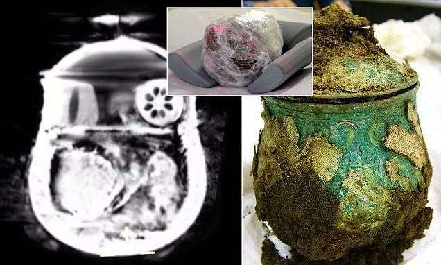
Scans of Viking pot reveal hidden brooches, gold ingots, and beads
Since researchers conducted a CT scan of the old artefact, the mystery around the contents of a Viking pot has been resolved. Archaeologists had been unable to open the pot to see what was inside, but its weight suggested it was full of treasure.
Experts were unable to open the 9th-century Carolingian pot (pictured), which was found on church land in Dumfries and Galloway in September
After undergoing a series of scans, the 1,200-year-old pot was found to contain up to at least five silver brooches and an ornate bead. It was among more than 100 objects discovered by metal detectorist Derek McLennan.
Other items include solid gold jewellery, armbands, and silver ingots. The find was deemed one of the most significant Viking hoards ever discovered in the UK, but the pot’s contents were a mystery.
Experts were concerned about damaging the 9th-century Carolingian pot when attempting to see what was inside. But now, the CT scanner at Borders General Hospital, Scotland, has revealed the ornate box contains around 20 silver, gold, and ivory items.
Mr McLennan, a retired businessman, said the latest discovery was ‘beautiful and exciting’.
‘It brought it all back to me when I saw what was inside the pot,’ he continued. I was like a kid looking in the sweet shop window unable to touch anything being on the other side of the glass.
‘Nothing else had been on my mind for two-and-half-months than seeing what was inside the pot, and then seeing it, there was a rush of emotion and was incredibly exciting. I was absolutely amazed by what was inside the pot. There seem to be 20 plus artifacts in the pot, while most of them seem to be broaches of some sort.
‘It’s a real mishmash of artifacts. Not everything comes across clear as there are different types of metal in there. There is hopefully something beautiful and exciting to look at when it comes out because [the owner] took the time to wrap these items.
‘I’m now waiting on the pot to be emptied, but I understand these things take time and it’s in the hands of the experts.’ A scan of the Carolingian pot was conducted by Dr. John Reid, a consultant radiographer at the BGH, who is also a keen amateur archaeologist.
Experts used a CT scanner to inspect what is inside the Viking pot. The circular shape in the upper right corner is said to be an ornate bead. The dome object to its left is a bone or ivory bead, and the coil curling from the bottom left to the center is five brooches. But the rectangular shape at the center remains a mystery
Derek McLennan, who found the trove, was approached by Richard Welander, head of collections with Historic Scotland, who was aware of the previous use of the hospital’s CT scanner for research. With the permission of the hospital chief, the pot was brought in for an evening scanning session (pictured)
He was approached by Richard Welander, head of collections with Historic Scotland, who was aware of the previous use of the hospital’s CT scanner for archaeological research. With the permission of hospital chief Calum Campbell, the pot was brought in for an evening scanning session.
‘This work takes place outwith normal hours and in no way impedes the important work we do for our human patients,’ said Dr. Reid. The scanner is both rapid and accurate, with the ability to produce 120 visual slices, and is accurate to within half a millimeter.’
The monitoring screen revealed the presence of five silver broaches, smaller gold ingots and ivory beads coated with gold – all wrapped in organic material, possibly leather.
Dr. Reid added: ‘The conservationists did not want to [grope] about and compromise this precious object. The discovery was made in early September by Mr. McLennan. Fellow metal detectorists Reverend Dr. David Bartholomew, who is a Church of Scotland minister of a rural Galloway charge, and Mike Smith, the pastor of an Elim Pentecostal Church in Galloway were also in the vicinity at the time.
The protected pot is shown being scanned in Borders General Hospital. The CT scanner consists of an X-ray tube that rotates around the object. These rays are received by a detector on the opposite side of the object, and an image of the scan is created. It produces 120 visual ‘slices’, and is accurate to within half a millimeter
Rev Dr. Bartholomew said: ‘We were searching elsewhere when Derek initially thought he’d discovered a Viking gaming piece.
‘A short time later he ran over to us waving a silver arm-ring and shouting ‘Viking’! It was tremendously exciting, especially when we noticed the silver cross lying face-downwards.
‘It was poking out from under the pile of silver ingots and decorated arm-rings, with a finely wound silver chain still attached to it.
The discovery was made in early September by retiree Derek McLennan. I was made on the Church of Scotland land, but the exact location hasn’t been revealed. A gold ring found in the hoard is pictured
An early medieval cross was also found among the hoard of Viking treasure. The cross is engraved with decorations that experts claim are highly unusual, and which finder Mr. McLennan believes may represent the four Gospels
‘It was a heart-stopping moment when the local archaeologist turned it over to reveal rich decoration on the other side.’
The hoard falls under the Scots law of treasure trove and is currently in the care of the Treasure Trove Unit. The law states that a reward must be made to the finder, and the reward is judged equivalent to the market value of the items. The Church of Scotland General Trustees, as the landowners, have reached an agreement with Mr McLennan about an equitable sharing of any proceeds, which will eventually be awarded.
The location of the find is not being revealed.
The Scottish Government, Treasure Trove Unit, and Historic Scotland are all involved in ensuring the area is properly protected while the full historical significance of the site is established.
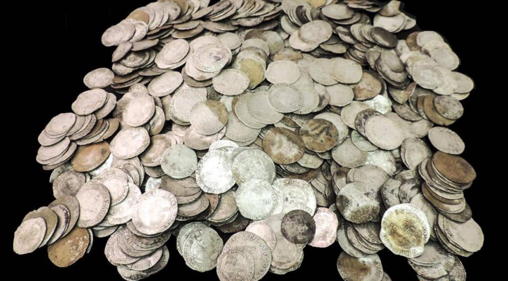
10,000 Roman coins unearthed by amateur metal detector enthusiast
An amateur metal detector enthusiast discovered a massive train with more than 10.000 Roman coins on his first ever treasure hunt.
The silver and bronze ‘nummi’ coins, dating from between 240AD and 320AD, were discovered in a farmer’s field near Shrewsbury, in Shropshire.
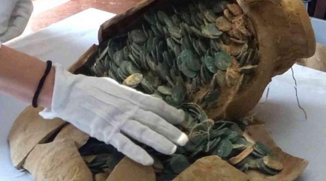
Finder Nick Davies, 30, was on his first treasure hunt when he discovered the coins, mostly crammed inside a buried 70lb clay pot. Experts say the coins have spent an estimated 1,700 years underground.
Strike it lucky: Nick Davies found this amazing haul of 10,000 Roman coins on his first-ever treasure hunt
The stunning collection of coins, most of which were found inside the broken brown pot, was uncovered by Nick during a search of land in the Shrewsbury area – just a month after he took up the hobby of metal detecting.
His amazing find is one of the largest collections of Roman coins ever discovered in Shropshire. And the haul could be put on display at Shrewsbury’s new £10million heritage center, it was revealed today.
It is also the biggest collection of Roman coins to be found in Britain this year. Nick, from Ford, Shropshire, said he never expected to find anything on his first treasure hunt – especially anything of any value. He recalled the discovery and described it as ‘fantastically exciting’.
Nick said: ‘The top of the pot had been broken in the ground and a large number of the coins spread in the area. All of these were recovered during the excavation with the help of a metal detector.
‘This added at least another 300 coins to the total – it’s fantastically exciting. I never expected to find such treasure on my first outing with the detector.’
The coins have now been sent to the British Museum for detailed examination before a report is sent to the coroner. Experts are expected to spend several months cleaning and separating the coins, which have fused together.
They will also give them further identification before sending them to the coroner. A treasure trove inquest is then expected to take place next year. Peter Reavill, finds liaison officer from the Portable Antiquities Scheme, records archaeological finds made by the public in England and Wales.
He said the coins were probably payment to a farmer or community at the end of a harvest. Speaking to the Shropshire Star, Mr. Reavill said the coins appear to date from the period 320AD to 340AD, late in the reign of Constantine I.
He said: ‘The coins date to the reign of Constantine I when Britain was being used to produce food for the Roman Empire.
‘It is possible these coins were paid to a farmer who buried them and used them as a kind of piggy-bank.’
Mr. Reavill said that among the coins were issues celebrating the anniversary of the founding of Rome and Constantinople. In total, the coins and the pot weigh more than 70lb.
He added: ‘This is probably one of the largest coin hoards ever discovered in Shropshire.
‘The finder, Nick Davies, bought his first metal detector a month ago and this is his first find made with it. The coins were placed in a very large storage jar which had been buried in the ground about 1,700 years ago.’
However, Mr. Reavill declined to put a figure on either the value of the coins or the pot until the findings of the inquest are known, but he described the discovery as a ‘large and important’ find.
Mr. Reavill said the exact location of the find could not be revealed for security reasons.
A number of exciting road works on a major road is not the first place you would expect to find a trove of Roman treasures, but that is exactly what people have discovered in a £ 380 million upgrade to a 12-km stretch of the A1 between Leeming Bar and Barton in Yorkshire have discovered. Archaeologists have now unearthed a staggering 177,000 artifacts from a Roman settlement dating back to 60AD that was on the site.
Archaeologists have unearthed a haul of more than 177,000 Roman artefacts under the A1 in Yorkshire. The discoveries have been described as ‘re-writing history’. Pictured is Dr Elizabeth Foulds a selection of the treasures
They have said the discovery is helping to rewrite history and providing new insights into life in Britain during the Roman occupation. And archaeologists have described the new discoveries as ‘re-writing history’.
Among the finds to have been recovered are a rare Roman brooch and a decorative miniature sword.
Archaeologists have also found the remnants of the town close to Scotch Corner, North Yorkshire, which could prove to be the earliest Roman settlement in the region. The Romans are thought to have only come to York a decade later than the settlement is thought to have been built.
Dr Steve Sherlock, who has led the archaeological project, said: ‘We’re effectively re-writing the history books because we didn’t know it was there or that there was anything so early.
‘Conventional wisdom tells us that in AD71 the Romans came over the Humber and settled in places like York and near Boroughbridge – but this site is even earlier.’
Dr. Sherlock described discovering traces of timber buildings, glass vessels, beads, and even remnants of crops as ‘quite spectacular’.
Among the finds to have been recovered is a rare Roman brooch (pictured) which would have been worn by Roman settlers in the area almost 2000 years ago
The Romans are thought to have only come to York a decade later than the settlement is thought to have been built. The dig site revealed ornamental as well as functional objects, such as this ornamental sword (pictured)
He said: ‘We didn’t just find one building, but a sequence of buildings going back hundreds of years, that nobody knew existed.
‘We can understand the impact of the site because of the amount of time it was occupied – over 300 years.’
Over the past two years, over 60 archaeologists have been working along the old Roman route known as the Great North Road, which ran adjacent to the current A1.
Dr Sherlock explained that, although they expected to find Roman deposits the ‘quality, quantity and extent went beyond expectations’.
Further discoveries have also been made at Catterick, North Yorks., which was occupied by the Romans around AD80.
Some of the larger pottery pieces were from broken vessels, such as large jugs for carrying olive oil (pictured)
Here a Roman town called Bainesse, just south of Catterick, has previously been found and much knowledge has now been gained following the excavation of a cemetery with 246 burials dating back to the first and third century.
Some people were buried with pots, beads, jewellery and even hobnail boots.
The bones will now be analysed to determine their age, sex and cause of death which archaeologists hope will reveal a number of exciting things.
The team are due to leave Catterick later this month but will continue to study and verify the findings – some of which will go to the York Museum Trust.
Dr. Hannah Russ, from Northern Archaeological Associates, said: ‘The quality and preservation of the artifacts and environmental remains from this scheme is outstanding.’
Further discoveries have also been made at Catterick, North Yorks., which was occupied by the Romans around AD80
The face of a 7500-year-old woman reveals Gibraltar’s earliest humans
The Minister of heritage Dr. John Cortes unveiled a historical reconstruction of the head of a Neolithic woman who lived in Gibraltar 7,500 years ago.
Archeologists who worked in the Gibraltar National Museum discovered and excavated their remains, called “Calpeia,” the classical name of the Rock from a burial site near Europa Point in 1996.
Recent advances permitted segments of her DNA to be extracted. A combination of the technology currently available and the skills of Gibraltar National Museum Conservator, Manuel Jaen, had made this in-house project a reality.
Assisting Dr Cortes at the unveiling was Director of the museum Professor Clive Finlayson, Dr Geraldine Finlayson, Stewart Finlayson and Mr Jaen.
Human hair was used in the reconstruction process that took Mr Jaen six months. Holding a 3D printed version of the skull found in 1996 during an excavation, Professor Finlayson explained the process of how Calpeia came to be.
“She was in a burial and we now know she was a she as she comes from the Neolithic period of around 5,400BC.”
“We were able to extract DNA from the skull so we know a number of things.”
“We know she was a female, we know she had features associated with dark hair, dark eyes and the interesting thing was when we look at her ancestry 10% of her genes were local Mesolithic hunter gathers but 90% of her genes were from Anatolia [modern day Turkey],” he said.
“I am not going to go into the ins and outs of Neanderthals being different species or not, but if the Neanderthal is a different linage and Nana is the first female Neanderthal, I think what you are going to see today is truly a modern human,” he added.
“Through Forensic data, & the key word is ‘forensic’, we have created Calpeia”
Calpeia’s skull had been deformed post-burial so the process of her reconstruction included the reshaping of a scanned copy of the skull, and completing the missing areas.
Dr Cortes described the work that Mr Jaen and the museum carried out as “extraordinary”.
He said: “When I saw what you are about to see a few days ago it was breath-taking, congratulations to Manuel for this incredible piece of work.”
“This young lady, I think she was late 30s early 40s, lived in Gibraltar seven and a half thousand years ago. She was buried in a cave at Europa Point.”
“I am told there was no agriculture in Gibraltar at that time, they were probably fishing living off the sea and living off the land.”
“But she was in Gibraltar, a Gibraltarian, though whether she was born here or travelled here we will never know. But, so many of us born here or who have travelled here consider ourselves Gibraltarian,” he added.
Dr Cortes said he, like Professor Finlayson, would not be drawn on whether Neanderthals are or not the same species as modern humans but stated that Calpeia was not a Neanderthal.
“So you are about to see the face of the first known Gibraltarian of seven and a half thousand years ago,” he said.
“So when you see her try and push your mind back all those years ago when the Rock was very, very different, still our Rock, still our Gibraltar, still lived, played and suffered and had their day to day life in a different way but they were humans just like us with the same emotions.”
Mysterious Shipwreck Artifacts Found Off England’s Coast To Be X-Rayed
Tons of items retrieved from the wreck of a sailing boat from the Dutch East India company will be scanned by new X-ray equipment to reveal hidden details.
In January 1740, after landing on Goodwin Sands, the Rooswijk [ a so-called ‘ retrochip ‘ built on long travels ] sank off Kent Coast. Archaeologists visited the wreck and recovered many artifacts — including silver coins and ingots, wooden chests, and a brass wine pot — between 2005 and 2018.
Due to a £150,000 grant from the Wolfson Foundation to upgrade Historic England X-ray equipment, many of these objects will now be examined in more detail.
Originally destined for Batavia — modern-day Jakarta — the merchant ship Rooswijk sank around 5 miles (8 kilometers) off of the British coast on its second voyage to the East, with none of its believed 237-strong crew surviving the accident.
Its wreck was first discovered at a depth of 79 feet (24 metres) by an amateur diver back in 2004 — with the bulk of recovery efforts taking place between 2005 and 2018, with the objects from the vessel legally belonging to the Dutch state. Among the artefacts recovered from the wreck were bars of silver, gold coins, knives, scabbards, human remains, pots, jars and thimbles.
The grant from the Wolfson Foundation charity will be used to upgrade the power and resolution of the equipment at at Historic England’s large, walk-in X-ray facility for scientific and archaeological analysis at Fort Cumberland, Portsmouth.
The existing facility has been at that centre of the organisation’s archaeological assessment, analysis and conservation work.
When the upgrade is complete, Rooswijk artefacts will be among the first to be scanned by the revamped facility, in a collaboration between Historic England and Rijksdienst Voor het Cultureel Erfgoed, the Netherlands’ cultural heritage agency.
Many of the finds from the wreck are covered with hard concretions of matter that will require the extra power of the new equipment to be successfully scanned.
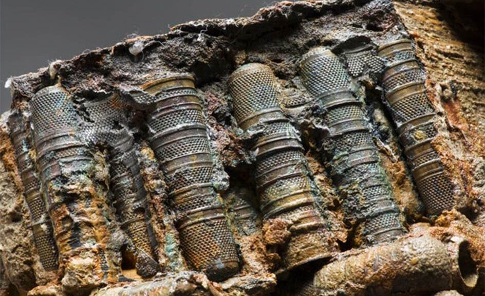
The Rooswijk — a so-called ‘retourschip’ built for long journeys — sank off of the coast of Kent in January 1740 after running aground on Goodwin Sands. Pictured, thimbles covered in hard concretions that were recovered from the wreck of the vessel
Archaeologists visited the wreck and recovered many artifacts — including silver coins and ingots, wooden chests, and a brass wine pot — between 2005 and 2018. Pictured, an X-ray image taken of one of the wooden chests from The Rooswijk, which contained thimbles
Many of the finds from the wreck are covered with hard concretions of matter that will require the extra power of the new equipment to be successfully scanned. Pictured, pewter jugs recovered from The Rooswijk
‘This generous investment will place Historic England at the forefront of heritage X-radiography for many years to come,’ said Historic England head Duncan Wilson.
‘With this new technology, we will be able to analyse, conserve and better understand many more objects recovered from historic shipwrecks or excavated from archaeological sites.’
‘We are very grateful to The Wolfson Foundation for their support to this vital grant.’
The new X-ray machinery will also ‘greatly improve’ the analysis of Roman-era artefacts, Historic England said — as the scanner will be able to penetrate dirt and debris build-ups around such objects without the risk of damaging them.
‘We are excited to support this important piece of equipment – bringing together Wolfson’s longstanding interests in science and heritage,’ said Wolfson Foundation chief executive Paul Ramsbottom.
‘The beauty of X-ray technology is the way in which it reveals hidden secrets of the past as well as helping with conservation.’
‘We are particularly delighted to be supporting the heritage sector at this challenging moment for us all.’
Its wreck was first discovered at a depth of 79 feet (24 meters) by an amateur diver back in 2004 — with the bulk of recovery efforts taking place between 2005 and 2018, with the objects from the vessel legally belonging to the Dutch state. Pictured, coins from the wreck
The new X-ray machinery will also ‘greatly improve’ the analysis of Roman-era artefacts, Historic England said — as the scanner will be able to penetrate dirt and debris build-ups around such objects without the risk of damaging them. Pictured, top, a piece of Roman armour covered in concretion and, bottom, the interior of such revealed by X-ray imaging.
Coins buried during the English Civil War found on the farm
A plowed farmer’s field in England is notable not because of crops, but because of coins.
A trove of over 1,000 coins dating to the English Civil War has been discovered in a field near the British village Ewerby, according to a report from Lincolnshire County Council.
The coins are relics from a time long past, with the most recent being from 1643. While a buried pot originally held them, they were reportedly found distributed throughout the soil.
This is the largest of the hoards that have been found from that time in the county, and it contains coins from the reigns of Edward VI, Elizabeth, Mary, James I, and Charles I
“This is a monumental find from the turbulent years of the English Civil War,” Adam Daubney, finds officer for the Portable Antiquities Scheme at Lincolnshire County Council, said in a statement.
The English Civil War spanned from 1642 to 1651, with the Royalists fighting with the Parliamentarians. It concluded with a Parliamentarian victory, and the execution of King Charles I.
“The area between Grantham and Boston was a zone of intense conflict between the Parliamentarians and the Royalists in the early years of the war, so we can think of the Ewerby hoard as being from the ‘front-line,’” Daubney said.
“The hoard tells us about the uncertainty and fear that must have been felt at the time, but quite why it was buried – and by whom – is impossible to say,” he added. “It might have been buried by someone who went off to fight and never returned.”
The value of the coins at the time was a little over £34, which was a substantial amount— more than enough for a “gentleman” of the era to subsist off for a year, according to Daubney.
The buried treasure was discovered in a ploughed field near the village of Ewerby near Sleaford in Lincolnshire