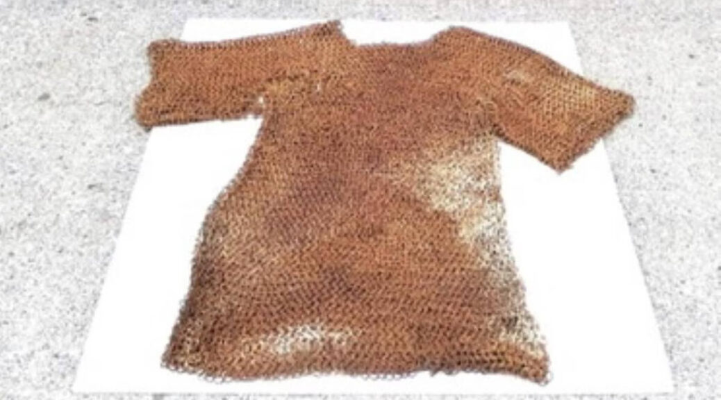
‘Extraordinary’ 800-year-old chain mail discovered in Co Longford shed
A vest of chain mail, which is more than 800 years old, has been handed into the Knights and Conquests Heritage Centre in Granard, Co Longford.
It is understood the chain mail dates back to 1172 shortly after the Normans arrived in Ireland.
At an event last weekend, a member of the public disclosed that they had a hauberk, or coat of chain mail, in their garden shed.
The centre’s general manager Bartle D’Arcy said he was astonished when a member of the public brought in the artefact, which is in excellent condition.
“We had a Norman heritage day as part of [national] heritage week. I was walking around wearing a chain mail coif when people came up to me and said that they had ‘some of that’ in their shed. I said ‘What do you mean you have some of that in your shed?’
“They brought it to me two days ago and it is a full hauberk, 800 years old. They took it out of a drain a few years ago with a digger and just had it in their shed. It is extraordinary.”
Mr D’Arcy brought the chain mail to the National Museum of Ireland on Thursday. Officers there said that they were amazed to see an intact hauberk, having only ever seen fragments of chain mail.
“It is an amazing, extraordinary find. This all happened because of a chance encounter. They didn’t know what it was because it got stuck in the digger bucket. Unless you knew your history you wouldn’t really know what it was.
“It wasn’t discovered in Granard but it was discovered locally, but we are protecting the identity of the person. We are doing everything by the book and have declared it to the museum and so on,” he said.
Plans are afoot to put the chain mail on display in Longford. Mr D’Arcy said the museum would take the chain mail away to carry out some work on it.
Mr D’Arcy said the chain mail was in such good condition because it was in the water for so many years.
“It only rusts if you have water and air and if it’s only in water it survives. When the digger brought it up it was in peat.”
It is understood the chain mail dates back to 1172 shortly after the Normans arrived in Ireland. It will be restored and preserved before it goes on display.
A Mysterious Partially Submerged Structure in Ireland is a Prehistoric Tomb, New Research Finds
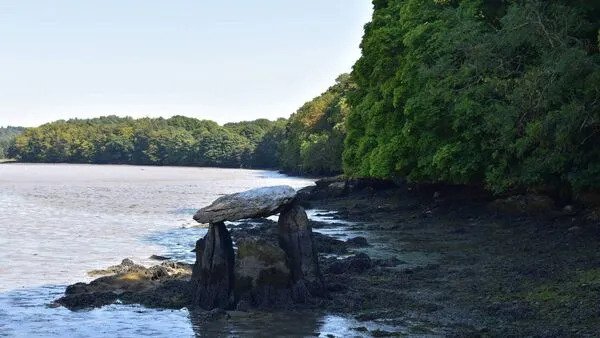
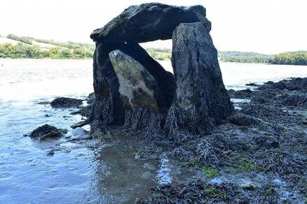
The Carraig á Mhaistin stone structure at Rostellan on the eastern shore of Cork Harbour, Ireland.
The tomb-like Carraig á Mhaistin stone structure, uncovered in Ireland’s Cork Harbour years ago, is now believed to be a megalithic dolmen.
Previously, experts have been unsure whether it was prehistoric or a 19th-century “folly.”
New research conducted by archaeologist Michael Gibbons indicated that the monument is in fact a megalithic dolmen.
A small chamber on the west side of an unknown cairn, a man-made stone stack marking a burial mound, measures 82 feet long by 15 feet wide. The cairn was previously concealed due to rising sea levels.
This is significant, as portal and court tombs “occasionally have intact long cairns which are both intended to provide structural support to the chamber itself, and to enhance visual presence in the landscape”, Gibbons told the Irish Examiner.
He believes that the cairn could extend well below the surface, “partially entombed in estuarine mud”.
It is unclear exactly when sea levels in the area rose, but they are believed to have been stable for the last 2,000 years.
There is only one other intertidal portal tomb on the island, and the Carraig á Mhaistin dolmen is one of three intertidal tombs in the country.
Among Irish folklore, portal tombs or dolmens were often known as Diarmuid and Gráinne’s bed—a final resting place for the fugitive couple who were pursued by Gráinne’s husband Fionn mac Cumhaill.
Many of these structures were built close to the coast; however, due to movement in the Atlantic ocean, many have not survived, including Sherkin Island’s sole megalithic tomb on Slievemore townland.
The Carraig á Mhaistin has not been previously included in the state’s survey of megalithic tombs in Ireland, conducted Ruaidhrí de Valera and Seán Ó Nualláin more than forty years ago, due to doubt surrounding its age.
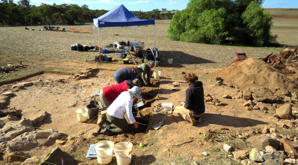
Unlike the world’s great metropolitan centres, ghost towns don’t usually enter sister-city partnerships. But in a paddock north of Adelaide, at a place called Baker’s Flat, there are traces of a village that is, in some ways, an unacknowledged sibling to dozens of similarly half-forgotten hamlets on the other side of the Earth.
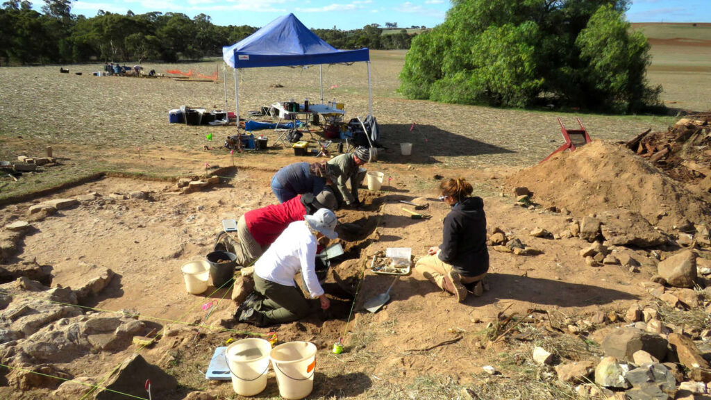
An archaeological dig of the remains of the Irish clachan, or village, at Baker’s Flat.
“You look at it now and it’s basically a field,” said Irish-Australian archaeologist Susan Arthure.
“There’s no evidence above the ground that all these people were there for nearly 100 years.”
The west of Ireland is today dotted with ghost villages: Settlements emptied by the starvation that swept the land in the 1840s and ’50s, when a combination of crop and political failure caused the deaths of hundreds of thousands and the migration of hundreds of thousands more.
Following the sea lanes, they flocked to London and Liverpool, Boston and Baltimore, Melbourne and Sydney, but also to sites such as Baker’s Flat. But unlike those abandoned villages in Ireland, this village owes its beginnings rather than its decline to the Great Famine.
“The famine was a driving force, it drove migration enormously,” Ms Arthure said.
“The people of Baker’s Flat were predominantly poor and Catholic, and at that time in South Australia they weren’t particularly well-favoured.”
Ms Arthure is currently putting the finishing touches on her PhD thesis through Flinders University. For her, the clachan remnants are partly a time machine and partly a treasure-trove: They offer glimpses of SA’s colonial past but are also a potential portal into the history of Ireland itself.
Whitewash, whiskey or sweat?
When Ms Arthure began digging at Baker’s Flat, she was expecting to — and did — unearth the remains of the thatched and whitewashed cottages so redolent of Irishness today.
But her most recent research focused on a distinctive round structure that was buried beneath scrap metal.
After initially thinking it may have been for making whitewash, Ms Arthure discounted that hypothesis because “there was no evidence at all of burning or preparing lime” — the basic ingredient in the paint.
Instead, her suspicions shifted to another typically Irish liquid.
“I thought perhaps it might have been an area for a poitín still, where people were distilling illegal whiskey,” Ms Arthure said.
“But one of the roads at the back of Baker’s Flat runs quite close to that area, so it’s not hidden enough.”
At a loss, she consulted experts in Ireland and one of them suggested a sweathouse.
“Sweathouses were very common in Ireland up until probably famine times,” Ms Arthure explained.
“They would be used to deal with illness, to help with rheumatic or arthritic pain, or with fever.”
These semi-subterranean and beehive-like buildings largely died out when modern medicines became more widely available and have “faded from memory” even in the Emerald Isle.
“Given all of the help people have given me, it would be really nice to be able to reciprocate by saying, ‘Here is some information from the SA landscape that maybe can shed some light on sweathouses in Ireland,'” Ms Arthure said.
“What is really exciting about the one here at Baker’s Flat is that we can look not only at how people were following the same traditions, but how they were adapting.”
From heyday to decline
Part of the appeal of Baker’s Flat lay in its proximity to Kapunda’s copper mine, which provided work for the local community. At its peak, as many as 500 people were living there — including a large population from County Clare in the west of Ireland, which was hardest hit by the famine.
Artefacts from the site reveal the richness of its cultural life. In addition to coins, buttons and brooches, there were buckles embossed with cricketers, seemingly in recognition of the local team that was dubbed Hibernian.
“It’s not very well known but, in the 19th century, cricket was one of the most popular sports in Ireland,” Ms Arthure said.
During her research, she identified about 145 family names linked to Baker’s Flat, including Driscoll, Donnellan, McInerney and Conolan.
As those families left for greener pastures, the Baker’s Flat clachan fell into decline and then desuetude, which left only a certain Ms O’Callahan as the last surviving resident.
Local historian Peter Swann, who is 84, recalls visiting her when he was a boy.
“There were only ruins then, except for one old house that this old lady lived in,” he said.
“She lived out there on her own. If you look there now, you see nothing. Everything’s gone.”
Three-quarters of a century before the Irish famine, in an act of astonishing literary prescience, the Anglo-Irish poet Oliver Goldsmith produced an epic called The Deserted Village.
A painted scene from Goldsmith’s poem today hangs in the Art Gallery of SA, and the following quatrain could easily serve as an epitaph for Baker’s Flat and countless sites across Ireland:
While, scourged by famine from the smiling land,
The mournful peasant leads his humble band;
And while he sinks, without one arm to save,
The country blooms—a garden, and a grave.
However, there is a crucial difference between the abandoned villages of Ireland and the clachan at Baker’s Flat.
If the former were sites of sorrow, the latter was emphatically a place of security, vitality and survival.
Connemara-based archaeologist Michael Gibbons now says there is conclusive evidence the Carraig á Mhaistin stone structure at Rostellan on the eastern shore of Cork Harbour is a megalithic dolmen.
New research looks set to answer a long-standing question about the status of a mysterious tomb-like structure uncovered in Cork Harbour many years ago.
Archaeologists have been split as to whether it was prehistoric or a more recent 19th-century “folly”.
However, Connemara-based archaeologist Michael Gibbons now says there is conclusive evidence the Carraig á Mhaistin stone structure at Rostellan on the eastern shore of Cork Harbour is a megalithic dolmen.
Mr Gibbons has also discovered a previously unrecognised cairn close to the dolmen which would have been concealed by rising sea levels, and which he is reporting to the National Monuments Service.
The Carraig á Mhaistin dolmen at Rostellan is listed by some guides as Ireland’s only inter-tidal portal tomb.
In fact, there are two such inter-tidal tombs, Mr Gibbons says.
The small chamber at the tomb stands at the western end of the cairn, which is 25m long and 4.5m wide.
He says doubt about Carraig á Mhaistin’s age meant it was not included in the State’s survey of megalithic tombs of Ireland conducted by Professor Ruaidhrí de Valera and Seán Ó Nualláin over 40 years ago.
“At that time, it was suggested that it could have a folly or type of ornamental structure commissioned by local gentry at the nearby Rostellan Castle estate, and dating from the 19th century,” Mr Gibbons says.
The small chamber at the tomb stands at the western end of the cairn, which is 25m long and 4.5m wide. Picture: Michael Gibbons
His recent field trip to Rostellan has thrown up additional details, including the discovery that the small chamber at the tomb stands at the western end of the cairn, which is 25m long and 4.5m wide.
This is significant, as a portal and court tombs “occasionally have intact long cairns which are both intended to provide structural support to the chamber itself, and to enhance visual presence in the landscape”, he says.
The cairn is “partially entombed in estuarine mud” and it is probable a great deal more of the structure is concealed below the surface, Mr Gibbons says in a report he has written on the monument.
He notes it is not known for certain when the area was inundated by rising sea levels, but levels at this part of the Cork Harbour shoreline are believed to have been stable for 2,000 years.
Mr Gibbons says the only other known inter-tidal portal tomb on the island is at “the Lag” on the river Ilen, between Skibbereen and Baltimore in West Cork.
Portal tombs or dolmens were often known as “Diarmuid and Gráinne’s bed”, being associated in folklore as resting places for the fugitive couple who were pursued by Fionn mac Cumhaill, Gráinne’s husband.
Mr Gibbons says many were built close to the coast, but the two known tombs in the inter-tidal zone may have been part of a wider network which did not survive the “high energy environment” of the Atlantic seaboard.
He says recent extreme weather has destroyed Sherkin Island’s sole megalithic tomb on Slievemore townland, just 3m to 4m above the high water mark.
Mr Gibbons says the Sherkin structure had been an example of a “very fine wedge tomb”, but it was initially severely hit by the storms of 2014, which caused substantial damage to coastal archaeology in a number of locations.
What remains of the Sherkin wedge tomb has been almost entirely eroded away by recent storms, but there are some structural stones remaining which would warrant a rescue excavation, he says.
Carvings Discovered at Ireland’s Grange Stone Circle
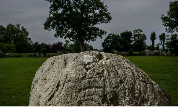
An aerial view of the Grange Stone Circle in Lough Gur, County Limerick.
An Irish archaeological photographer has discovered a remarkable series of prehistoric carvings at the Grange Stone Circle in Lough Gur, County Limerick.
Ken Williams, a leading Irish archaeological photographer, has developed methods of lighting stones so that they can be photographed to maximum effect, allowing him to find a series of carvings over the past few years.
Williams was returning to check the stones at Grange Stone Circle as part of his research when he discovered the new carvings.
The new carvings are particularly spectacular due to the presence of concentric circles and arcs found on the back and sides of a stone at the north entrance passage to the prehistoric enclosure.
Dr. Elizabeth Shee Twohig, who has published extensive research on megalithic and rock art, remarked that the carvings are extremely rare for Munster and Connacht.
“The carvings are quite like those at passage tombs in the North and East of the country, such as Knowth and Newgrange, but there is only a single carved stone of this kind in Munster or Connaught,” Dr. Shee Twohig said in a statement.
“It is possible that the stone is contemporary with the banked enclosure henge at c.3000 BC and was incorporated into the circle built inside the enclosure at a slightly later date.”
The Grange Stone Circle in Lough Gur, County Limerick.
Minister of State for Heritage Malcolm Noonan welcomed the discovery of the carvings.
“This is a site that has both captivated and intrigued locals and visitors for many years. It shows yet again the capacity our national monuments have to surprise and engage us,” he said in a statement.
The Grange Stone Circle is the largest standing stone circle in Ireland, measuring 150 ft in diameter and enclosed by 113 stones.
The circle’s largest stone is Rannach Chruim Duibh, which weighs over 40 tons and is over 13 ft tall.
The circle comprises a ring of continuous upright stones backed by a nine-meter-wide earthen bank reaching 1.2 meters in height.
Ken Williams said he plans to publish the new carvings in an academic paper, where he will describe the art and discuss comparable examples.
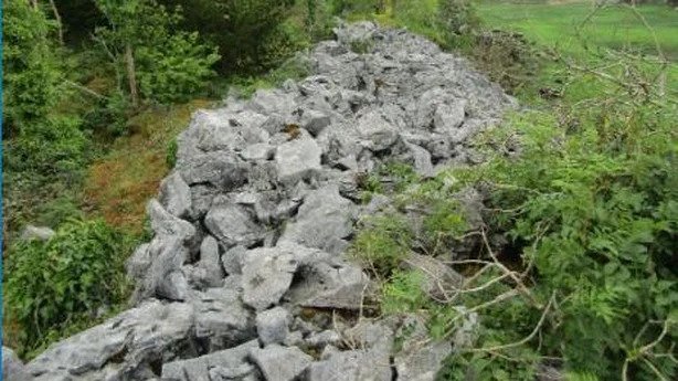
A Galway archaeologist has discovered what he describes as one of the most extraordinary monuments of probable Bronze Age in Ireland.
Michael Gibbons identified the large fortress, which is bound by turloughs or seasonal lakes, within the park at Coole, during fieldwork in the Burren lowlands east of Gort in Co Galway.
Working with Muintearas, the Gaeltacht education project, Mr Gibbons said the site had been known previously, but its antiquity was questioned.
However, his recent survey of the area indicates it is a unique fortress which used the turloughs as part of its defence and is likely to date from between 800 and 1200BC.
Measuring about 400m north-south and 110m east-west, the archaeologist said that it is comparable to Dún Aonghasa on Inis Mhór, and a couple of hundred people could have lived there.
Mr Gibbons said the site is like a giant lake-dwelling, utilising the turloughs in a very special way and set in a magical landscape.
Much of it is covered in dense woodland but he hopes that further research and analysis of LiDAR data from aerial surveys will reveal many Bronze Age round houses within the ramparts.
The fotresses is located within coole park
Describing it as an incredible find, the CEO of Muintearas, Seán Ó Coistealbha, said it is a huge addition to the archaeology of the area.
“Enormous work would have gone into constructing it by men and women in ancient times,” he said.
“We are just skirting around the stone ramparts of this community with a wealth of information yet to be discovered.”
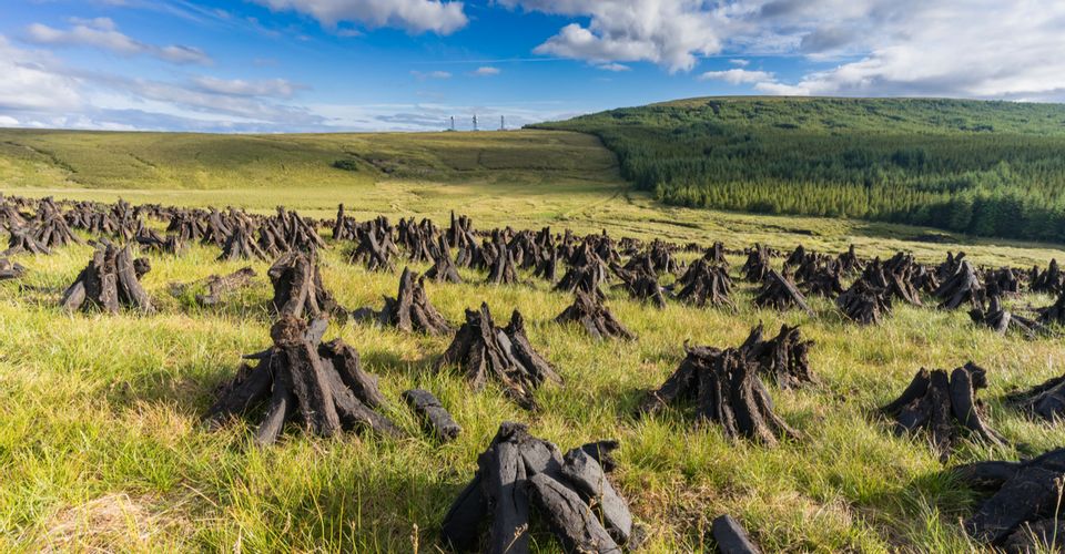
Ireland is famous for its peat bogs – peat is an accumulation of partially decayed vegetation or organic matter. They are the most efficient carbon sink on earth and cover 1.4 million square miles of the earth. They also tend to preserve bodies and artefacts that wind up in them, so they are a great source of archaeological findings of the Neolithic and Iron Age periods.
Peat bogs don’t normally make the top lists of things to see and do while in Ireland, but they are a window into the past. Another attraction in Ireland is Sean’s Bar – it is reputed to be the oldest pub in Europe having been established in 900 AD.
The Development Of The Peat Bogs Of Ireland
Bogs are one of the things that characterize Ireland. They cover around 1,200,000 hectares or around a sixth of the island. Only Finland has more bogs relative to its size than Ireland in Europe.
There are two very distinctive types of bogs blanket bogs and raised bogs.
1.Blanket Bogs: Expensive And Generally Form In Wet or Upland Areas 2. Raised Bogs: Smaller And Generally Form In Lowland Areas
Blanket bogs are found wherever there is high rainfall and in Ireland, that’s particularly in the west. They are by far the largest in Ireland and have formed because of human interaction.
After the Ice Age, Ireland was slowly colonized and covered with forests and by 4000 BC Ireland was almost entirely forested. Then the Neolithic Age farmers came and started to clear the land to build farms. First, they cleared the upland areas because forests were not so thick there. But without the trees, the nutrients in the soil became washing out (or leached). The soil became more acidic and the land became waterlogged.
By the Bronze Age around 500 BC, farmers were clearing the lower lands as the uplands were no longer usable. But the debris did not decompose and a layer of peat began to build up. The peat also buried the remains of the Neolithic farms.
By the Norman era around 1,000 AD, the lowlands were almost completely devoid of forests and blanket bogs were well established.
Preserved Kings, Sacrifices, And Artifacts In The Bogs
Go to the National Museum of Ireland and one will see the Kingship and Sacrifice exhibit. It is the result of findings from the museum’s Bog Bodies Research Project. The project was initiated following the discovery of two Iron Age bog bodies at Oldcroghan, Co. Offaly, and Clonycavan, Co. Meath.
The remains of these bodies were dated to between 40 BC and 200 BC and were notable for being in a good state of preservation. The museum offers exhibits based on the theory that human sacrifice and the deposition of the victims in bogs along tribal boundaries are related to sovereignty and kingship rituals during the Iron Age.
Preserved Bog Bodies: Gallagh Man (Co. Galway) Baronstown West Man (Co. Kildare)
Some exhibits include preserved bodies, royal regalia, weapons, boundary markers, horse trappings, and other artefacts. The exhibits also delve into what has been discovered in other Iron Age bogs in Denmark, Germany, The Netherlands, and England.
One can also learn about Cashel Man. He was found naked in at least two meters of peat with his head, neck, and left arm removed by the milling machine.
Cashel Man:
Age: 20-25 Years Oldest: One Of the Oldest Bog Bodies In Europe Date: 2,000 BC
He was a young adult male and the wounds on his body suggest he had been the victim of human sacrifice (there were injuries on the lower back and a broken arm). Although the cause of death was not possible to know because of the damage from the milling machine.
It is known that in the past the ritual killing of young men took place in ancient Ireland.
Céide Fields – Neolithic Farms
“Beneath the wild boglands of north Mayo lies a system of fields, dwelling areas and megalithic tombs which together make up the most extensive Stone Age monument in the world.”
Heritage Ireland
The Céide Fields is an archaeological site in the west of Ireland and is described as the most extensive Neolithic site in Ireland. It has the oldest known field system anywhere in the world and is thought to be around 5,500 years old.
Today it is on UNESCO’s tentative list to be World Heritage-listed and was originally discovered in the 1930s.
It wasn’t for another 40 years that they were studied archaeologically. What was discovered under the peat bog was a complex of fields, houses, and megalithic tombs concealed by the growth of blanket bogs over the course of many centuries.
The people who lived there were farmers who cleared large areas of forest to farm.
As of the time of writing the site is closed to the public because of ongoing work, check their website for current information.
Log Boats Recovered from River in Northern Ireland
History lies beneath the riverbeds of northwest Ireland. Every so often, when conditions allow, archaeologists are rewarded with another offering from the distant past.
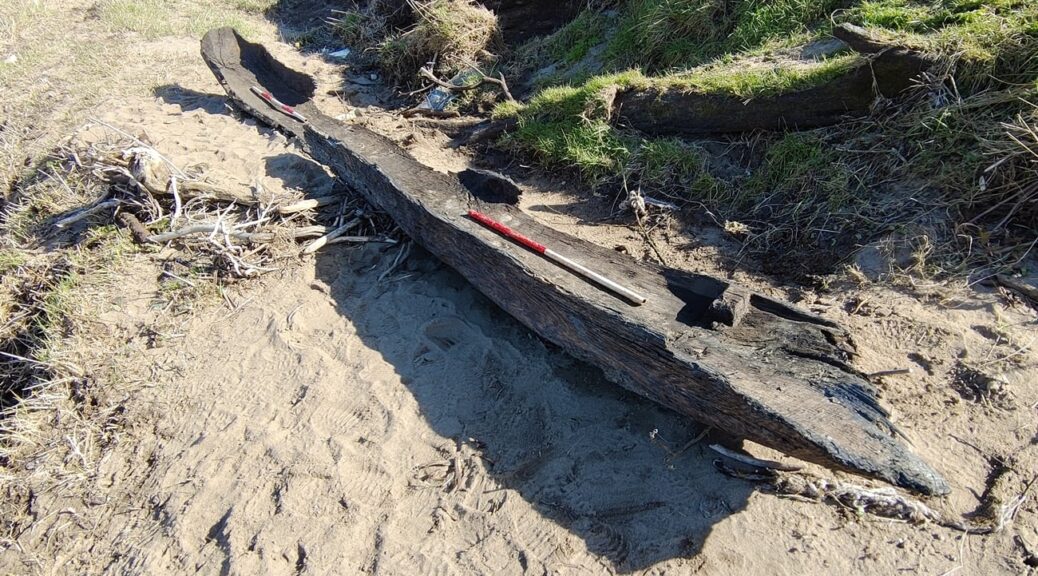
Two more vessels, known as log boats or dugout boats, were found at a site near the Lifford Bridge
Two more boats understood to be from the medieval era, have emerged from the River Foyle. The boats, known as longboats or dugout boats, were found at a “dugout boat hotspot” near the Lifford Bridge. The bridge connects the towns of Strabane in Northern Ireland and Lifford, in County Donegal in the Republic of Ireland.
Marine archaeologist Dr Niall Gregory said the two boats now bring the total number found at this particular section of the river to 15. Overall, 21 such boats have been found at the confluence (meeting point) of the Rivers Mourne and Finn into the River Foyle.
Logboat’s are made from hollowed-out trees and can vary in size depending on the tree trunk used, Dr Gregory told BBC News NI.
About 500 of these dugout boats have been found on the island of Ireland
About 500 log boats have been found across the island of Ireland, he said. One of the largest recorded was found in lower Lough Erne and measured nearly 60ft (18m) long and 3.2ft (1m) wide.
“These two boats found at the Lifford Bridge site were cargo ferry boats,” he said.
“These boats were designed as workhorses, to move and manoeuvre with some degree of agility within a moderate to strong current.
“These two boats are from a dugout boat hotspot where they have appeared over the years, usually after seasonal high-water flows.”
‘Taking a dander’
Logboat’s are “notoriously difficult” to date based upon hull size and shape alone, and carbon dating is the only definitive means of obtaining a conclusive date.
Dr Gregory estimates – based on the hull shape, use of medieval nails, distorted wood grain and remains of sapwood on the exterior – that they are of a medieval era.
Previous boats found at the site have been dated from between 600 AD to 1520 AD, he said. Dr Gregory believes these boats, from their characteristics, are more likely to be later rather than earlier in that range.
Logboat’s are made from a hollowed-out tree and can vary drastically in size
Eamon Logue, from the Strabane-Lifford Anglers Association, was one of the first people to stumble across the uncovered remains.
Speaking to BBC Radio Foyle’s Mark Paterson Show, Mr Logue said one of the boats seemed in such miraculous condition that it looked like someone had parked it there.
Previous vessels found at the Lifford bridge site have dated from about 600 AD to 1520 AD
“Me and a friend were just taking dander down the River Foyle.
“We were about 100 yards down the bank and we have just seen it, at the side of the river, like someone had parked it there.
“There were big floods just a few weeks before, we think it has either been dislodged or the bank has caved away and exposed it.
“We have walked this river for years and found different bits but this was different.”
Nail and timber samples from the boats have now been sent to Dr Rena Maguire of Queen’s University Belfast.
Dr Maguire, who is a metallurgical specialist, will undertake an analysis of the nails and also radio-carbon date the timbers to get a more exact date. Only time will tell if, or rather when, more of these boats will reappear along the banks of the Foyle.