Treasure worth over $1 million found in the Rocky Mountains after a 10-year search
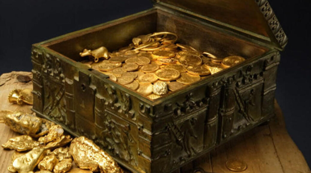
10-year treasure search is over. Forrest Fenn, a former military pilot, art collector and author who claims to have hidden a treasure chest worth more than 1 million dollars somewhere in the Rocky Mountains in 2010 – attracting worldwide adventure-looking adventurers – finally found the treasuries this weekend in a blog post.
Treasure worth over $1 million found in the Rocky Mountains after a 10-year search
The treasure was found under a canopy of stars in the lush, forested vegetation of the Rocky Mountains, and had not moved from the spot where I hid it more than 10 years ago,”
Fenn wrote Saturday on a blog that explaining to people who were looking for it the end of the treasure hunt: “I do not know who was there but the poem from my book led him to the exact spot,” he wrote.
Fenn confirmed the news to the Santa Fe New Mexican, saying the person who found the treasure chest provided a photograph as evidence of its discovery. Fenn would not confirm where the treasure was found or the identity of the person who found it, only saying the individual was “from back East.”
Forrest Fenn
The discovery puts an end to a quest that Fenn himself has said drew as many as 350,000 people to the Rocky Mountains region in search of the hidden treasure.
The bronze chest was filled with gold coins and rare artifacts with Fenn coming back over the years to add to its bounty. Clues to the treasure’s location were included in a poem in Fenn’s self-published memoir, The Thrill of the Chase, also published in 2010.
Throughout the years, Fenn has narrowed down the search area to the geographical region of the Rocky Mountains and within the states of New Mexico, Colorado, Wyoming, and Montana.
A treasure chest hidden in the Rocky Mountains has been found.
In previous interviews, Fenn said he buried the treasure as a way to give people hope—something he was compelled to do after surviving a terminal cancer diagnosis in 1988.
But the treasure hunt has been controversial, and even dangerous, from the start.
Some say the treasure hunt was a hoax, and the Santa Fe New Mexican reported that five people died while in pursuit of it, though Motherboard has been unable to independently verify those deaths.
In 2017 the New Mexico state police chief asked Fenn to call off the treasure search out of concern for the safety of those seeking it. And a woman who said she solved Fenn’s puzzle claimed that she was “hacked” and that another person stole it out from under her and plans to take legal action. Fenn, for his part, has thus far declined to provide a photograph of the solve.
Dal Neitzel runs a blog popular with those searching for the treasure—the same blog on which Fenn announced Saturday the treasure had been found. Neitzel made his first trip in search of the treasure after hearing about it from a note on Fenn’s website in 2010 and said he has made at least 80 trips in search of the treasure since. He said he had mixed feelings about the news that the treasure had been found.
“Disappointment that it was not me who found it and relief that I can stop being a professional blogger,” Neitzel told Motherboard in an email.
Neitzel said what is now important is that Fenn discloses where the treasure was hidden, for the sake of all the treasure seekers who spent years trying to find it.
“We each want to know how close we actually got,” Neitzel said. “Whether our ideas were solid or crazy.’
Though Neitzel never found the treasure, he doesn’t regret the time he spent looking for it and said he will continue making trips out to the area where it was hidden.
“The beauty of the mountains will be my stated goal from this point forward, rather than the chest,” Neitzel said.
Mexico: 3,000-year-old Mayan ceremonial complex discovered in Tabasco
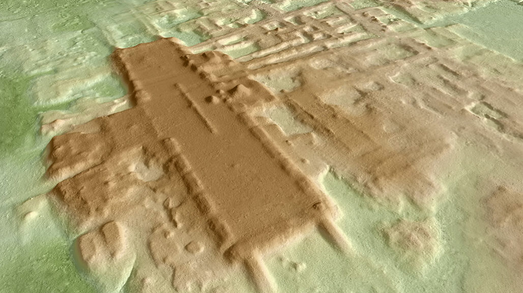
In the latest breakthrough discovery of lost civilization, researchers have found the largest and the oldest Mayan site through a unique laser technology called lidar.
Using the aerial remote-sensing method, researchers at the University of Arizona found a colossal rectangular elevated platform that was built between 1000 and 800BC in Tabasco state, Mexico.
The new structure is located at the site called Aguada Fenix that liest near the border of Guatemala, which in its total volume exceeds the 1,500-year-old Great Pyramid of Giza in Egypt.
The site, called Aguada Fénix, is located in the state of Tabasco, at the base of the Gulf of Mexico. It’s so vast for its age, the find is making archaeologists recalibrate their timelines on the architectural capabilities of the mysterious Maya.
Aguada Fénix, which measures over 1,400 meters (almost 4,600 ft) in length at its greatest extent, dates to a similar timeframe, with researchers estimating it was built between 1000 and 800 BCE – but its immense size and scope make it unlike anything found before from the period.
Airborne remote sensing allowed scientists to create a 3-D rendering of newly discovered Aguada Fénix, including the 3,000-year-old Maya site’s massive ceremonial plateau with a platform and mound in its center.
“To our knowledge, this is the oldest monumental construction ever found in the Maya area and the largest in the entire pre-Hispanic history of the region,” the researchers, led by archaeologist Takeshi Inomata from the University of Arizona, explain in a new paper about the discovery.
What’s even more staggering is that this huge, unknown structure has actually been hiding in plain sight for centuries, seemingly unrecognised by the modern Mexicans living their lives on top of the vast complex.
“This area is developed,” Inomata says. “It’s not the jungle; people live there. But this site was not known because it is so flat and huge. It just looks like a natural landscape.”
Despite Aguada Fénix’s inconspicuousness, it can’t hide from non-human eyes.
Aerial surveys using LIDAR detected the anomaly, revealing an elevated platform measuring 1,413 metres north to south, and 399 metres east to west, and extending up to 15 metres above the surrounding area.
“Artificial plateaus may be characterised as horizontal monumentality, which contrasts with the vertical dimensions of pyramids,” the authors write, noting the layout of Aguada Fénix marks it as an example of the Middle Formative Usumacinta (MFU) pattern, characterised by a rectangular shape defined by rows of low mounds.
Nine wide causeways extend from the platform, which is also surrounded by a number of smaller structures, including smaller MFU complexes and artificial reservoirs.
It’s difficult to see the remains of Aguada Fénix from this aerial view of the landscape today. But laser technology gave researchers a look at the site’s causeways and reservoirs, in front, and ceremonial area, in back.
The site bears certain similarities to the Olmec sites San Lorenzo and La Venta in the nearby state of Veracruz, but Aguada Fénix’s lack of human-shaped statues could provide a clue about the ancient Maya that inhabited this complex, distinguishing them from the Olmec.
“Unlike those Olmec centres, Aguada Fénix does not exhibit clear indicators of marked social inequality, such as sculptures representing high-status individuals,” the authors write.
“The only stone sculpture found so far at Aguada Fénix depicts an animal.”
Excavations of the oldest and largest Maya ceremonial structure unearthed an animal sculpture, possibly representing a white-lipped peccary or a coatimundi, that the researchers nicknamed Choco.
If the researchers are right about that, the site could be hugely important in helping us understand more about how these enigmatic human societies functioned and organized themselves – especially if they embraced a communal form of societal structure that rejected hierarchical forms.
“This kind of understanding gives us important implications about human capability, and the potential of human groups,” Inomata says.
“You may not necessarily need a well-organized government to carry out these kinds of huge projects. People can work together to achieve amazing results.”
Grave of the king who laid foundations for Mayan civilization in 700 B.C. unearthed
This is the extraordinary grave of an ancient king credited with laying the foundations for the Mayan civilization more than 2,000 years ago, which has been discovered by archaeologists in Guatemala.
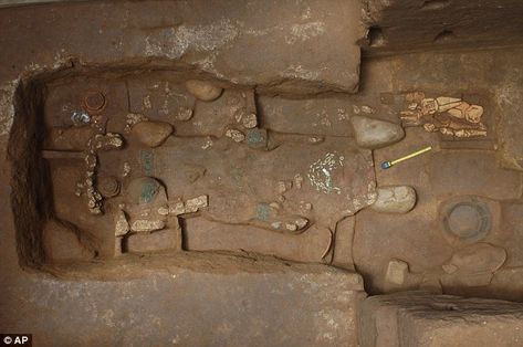
Researchers said they uncovered the grave of King K’utz Chman, a priest who is believed to have reigned around 700 B.C., at the Tak’alik Ab’aj dig in Retalhuleu, in the south-west of the country.
Packed with jade jewels and other artefacts, it is the oldest royal Mayan burial ground ever found.
‘He was the big chief,’ government archaeologist Miguel Orrego said. ‘The ruler who bridged the gaps between Olmec (pre-Mayan) and Mayan cultures and initiated the slow transition to Mayan rule.’
Historians believe he was the first leader to introduce elements that would define Mayan culture, such as building pyramids instead of square structures and carving sculptures that profiled royal families.
Guatemala is studded with ruins from the ancient Mayan civilization, which thrived between A.D. 250 and 800 and extended from modern-day Honduras to central Mexico. The Olmec Empire began to fade around 400 B.C. while Mayans grew in number and wrested control of trade routes.
Inside the grave, the team found glistening jade jewels including a necklace with a pendant carved in the shape of a vulture’s head, a symbol that represented power and high economic status, and that was given to respected elder men.
Amazing find: More pots found in the royal tomb of the Mayan king, located to the west of Guatemala City
Verification: Scientists found the grave in June, but it has taken until now to confirm it belonged to K’utz Chman
Past times: Ceramic dolls found in the royal tomb of the Mayan king discovered at the Tak’alik Ab’aj dig
This symbol gives this burial greater importance,’ Mr. Orrego said. ‘This glyph says he (is) one of the earliest rulers of Tak’alik Ab’aj.’
Scientists found the grave last year, but it has taken until now for experts to verify it belonged to K’utz Chman.
Although no human remains were found at the site, the carbon-dated artefacts suggest that the king was buried between 770 to 510 B.C.
‘The richness of the artifacts tells us he was an important and powerful religious leader,’ archaeologist Christa Schieber said. ‘He was very likely the person who began to make the changes in the system and transition into the Mayan world.’
Jade beans: Guatemala is studded with amazing ruins from the Mayans, who thrived between A.D. 250 and 800
Importance: The team found glistening jade jewels, including a necklace with a pendant carved in the shape of a vulture’s head – a symbol that represented power and high economic status
On location: The site of the discovery of the royal tomb at the Tak’alik Ab’aj dig in Retalhuleu in Guatemala
Experts said the array of jade articles in the tomb could provide clues about production and trade.
Susan Gillespie, an archaeologist at the University of Florida who was not involved in the excavation, spoke about the find.
She said older tombs have been found from ruling circles at the Mayan site of Copan in Honduras as well as in southern Mexico, where the pre-Mayan Olmec culture flourished.
Olmec influences are present in the area around Tak’alik Ab’aj, indicating possible links.
She said that because it is near a jadeite production center, the find could shed light on early techniques and trade in the stone, which was considered by the Maya to have sacred properties.
Archaeologists Discover More Than 200-Year-Old Shipwreck In Mexico’s Caribbean.
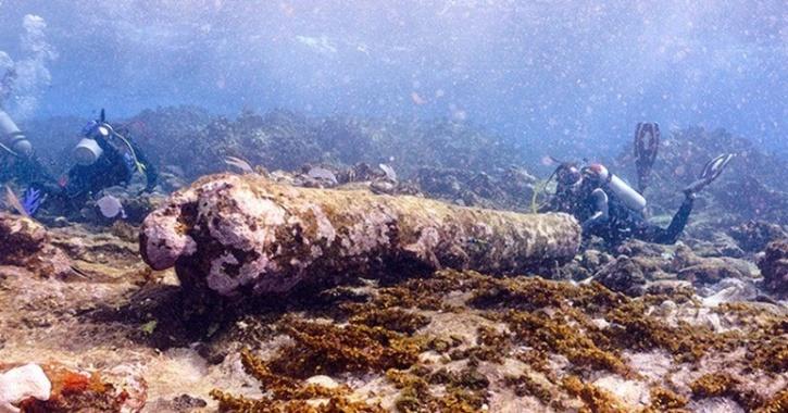
QUINTANA ROO, MEXICO— BBC reports that an eight-foot cannon, anchor, and pig-iron ingots thought to have been used as a ship’s ballast were spotted by a fisherman in the Caribbean Sea off the coast of southern Mexico.
The wreckage rests in shallow waters and rough ocean currents at the Banco Chinchorro atoll reef, a dangerous area where 70 historic shipwrecks have been registered.
Archaeologists from Mexico’s National Institute of Anthropology and History said the vessel could be the remains of an English sailing ship built in the late eighteenth or early nineteenth century.
They believe the ship sank more than 200 years ago after hitting a reef. While most of the wood has rotted away, the ship’s cannon and anchor are well preserved.
The wreck has been named after Manuel Polanco, the fisherman who first spotted it and reported it to Mexico’s National Archaeological Institute.
‘Nightmare Reef’
The wreck was found in the waters of the Banco Chinchorro atoll reef, about 35km from Majahual on Mexico’s Caribbean coast, and is thought to date back to the late 18th or early 19th Century.
The archaeologists think that it sank after hitting the Chinchorro Bank, which was colloquially known as “Nightmare reef” or “Sleep-robbing reef” because of the dangers it posed to seafarers.
Mexico has declared the area an underwater cultural heritage site because of the many wrecks which can be found there, including two Spanish galleons.
The Manuel Polanco is the seventieth wreck to be found in the area.
The anchor was found in shallow waters at Banco Chinchorro
Underwater archaeologists said the currents where the cannon was found were strong
Mexico’s National Archaeological Institute (INAH) was alerted to the remains of the sailing ship – an anchor, a 2.5m-long (8ft) cannon, and pig iron ingots believed to have been used for ballast – by fisherman Manuel Polanco.
Mr. Polanco, who is now retired and in his 80s, already made some remarkable discoveries in the 1960s and 70s.
Among his best-known finds are the wreck of a ship dubbed “40 cañones” (40 cannons) and “The Angel”, a sailing ship which transported logwood – a natural source of purple dye – from Mexico to Europe.
He spotted the remains which INAH archaeologists are now studying as early as the 1990s, but archaeologists only carried out their first dives to inspect it in the past two months.
To honour his contribution to underwater archaeology, INAH scientists decided to name the newly located wreck after Mr. Polanco.
Due to his advanced age, Mr. Polanco did not accompany the archaeologists but sent his son Benito to help archaeologists locate the wreck instead.
The INAH scientists think the remains could have belonged to a British sailing ship but said they needed to carry out further studies before they could confirm its origin.
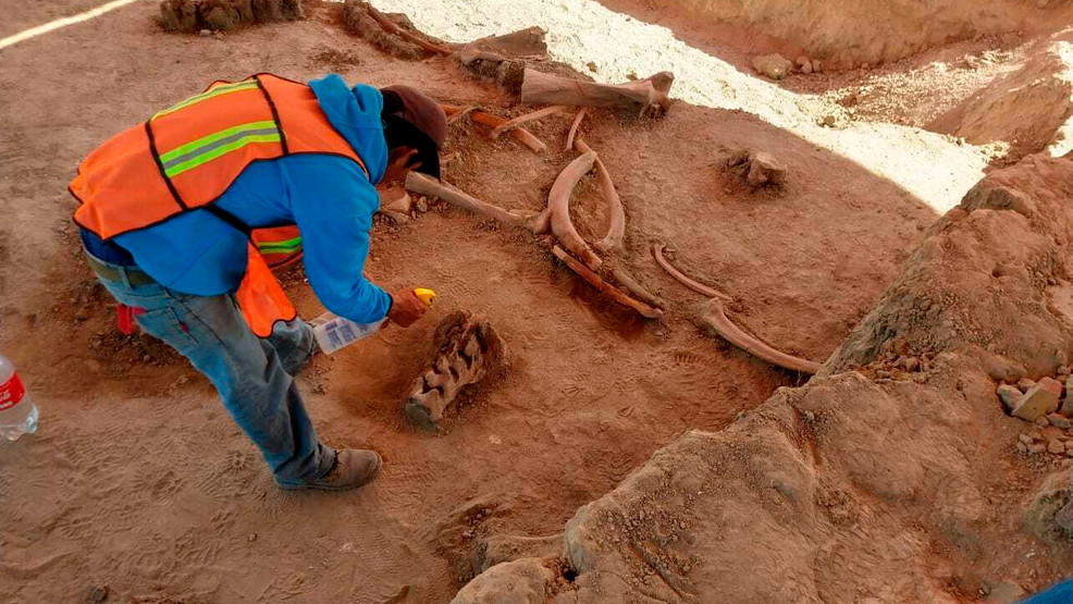
Skeletons of over 60 mammoths found under-construction site of future Mexico airport
In the future airport of the city, a team of archeologists working near Mexico City has discovered the remains of more than 60 mammoths.
The bone fragments found at the proposed construction site of the Felipe Angeles International Airport date back some 15,000 years, said the Mexican National Institute of Anthropology and History (INAH).
Both discoveries reveal how appealing the area — once a shallow lake — was for the mammoths.
Thursday, the National Institute of Anthropology and History said there was no immediate evidence that the 60 mammoths newly discovered at the old Santa Lucia military airbase had been butchered by humans.
The remains were uncovered close to the spot where the airport’s future control tower is to be built. INAH excavators have been working at the site – some 50 kilometers (about 30 miles) north of the capital – since April last year, seeking animal remains from the Pleistocene era.
Durante los trabajos para construir el nuevo Aeropuerto Internacional “General Felipe Ángeles”, en Santa Lucía, Estado de México, trabajadores han encontrado restos de 60 mamuts, informó el Instituto Nacional de Antropología e Historia (INAH).
The team reported in December that it had found the bones of a far smaller number of animals at the old Santa Lucia Air Base, a military airport being converted for civilian use.
The area was formerly submerged under the Xaltocan Lake, part of the Mexican Basin, and a focal point of the country’s pre-Colombian civilization. Traps for the hunting of mammoths, thought to have been dug soon after the lake dried up, were found at the site last year.
Almost all of the giant skeletons are thought to belong to the Colombian mammoth species.
Other types of fauna, including bison, camels, and horses were also found, as well as bones of humans buried in the pre-Hispanic era and various artifacts.
“The main challenge is that the richness of fauna and relics is greater than we had considered,” Pedro Francisco Sánchez Nava, INAH’s national anthropology coordinator told Mexico’s Excelsiornewspaper.
INAH says the discoveries are not intended to put a brake on the building of the airport, and that they had little impact on the building work.
“It would be a lie to say that we have not had an influence on the work being carried out, but we are working in coordination with those responsible,” said Sanchez Nava. “We are able to continue at our own pace without having too much influence on the times of the work.”
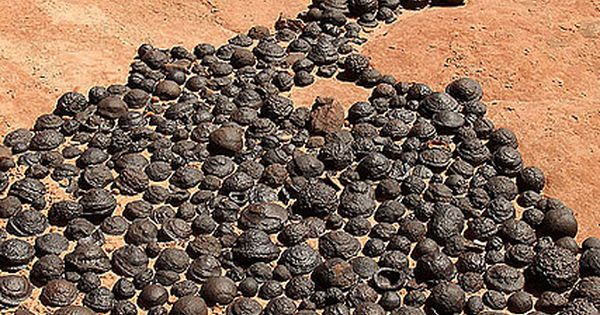
25 Million Old Moqui marbles naturally occurring iron oxide concretions that arise from Navajo sandstone
Walkers wandering through the sandy canyons of Utah sometimes come across a strange sight. Where the Navajo Sandstone loses its iconic peach, orange, and red stripes, hundreds of round, iron-coated stones often litter the ground.
Sandstone balls are cemented with a strong layer of iron oxide minerals. Moqui marbles, the colored stones spread over the Utah and Arizona, are often called as a stone, and they fall off pale, cream-colored Navajo Sandstone beds when wind and water wash away the softer rock are often known by the name Moqui.
For decades, the rocks were simply a geological oddity. Then, look-alikes were discovered on Mars (the so-called Martian blueberries). The milestone — among the early evidence for water on Mars — boosted interest in Earth’s iron baubles.
Now, a new study reveals that the Moqui marbles are no more than 25 million years old — a sharp contrast to the 190-million-year-old Navajo Sandstone. Marbles scattered on sandstone slopes in Grand Staircase-Escalante National Monument are only 2 million to 5 million years old. And on Arizona’s Paria Plateau, the marbles’ iron oxide rind is as young as 300,000 years old, researchers report in the September 2014 issue of the Geological Society of America Bulletin.
“They really represent a record of how water moved the rock millions of years ago, and the next generation can use them to understand water and life on other planets,” said Marjorie Chan, co-author of the new study and a geologist at the University of Utah in Salt Lake City.
Odd balls
The moqui marbles’ precise ages come from a radioactive clock. The iron oxide minerals contain traces of radioactive uranium and thorium, and these decay by expelling helium. Tallying the elements reveals the time since the minerals formed. The innovative technique may help resolve different models of how the stone spheres formed. Scientists agree that the iron comes from the bone-white Navajo Sandstone layers, stripped bare of their mineral paint by percolating groundwater. A subtle film of hematite, or iron oxide, colors the iconic red cliffs and canyons.
Chemical reactions fused the moqui marbles with iron, but the details haven’t been settled. Some researchers now think tiny microbes spurred the chemical process, and that similar concretions on Mars may one day reveal signs of ancient life.
“The discoveries on Mars helped push us to better understand the setting here on Earth, and what we do on Earth feeds back into helping interpret Mars,” Chan told fox news.
Concretions of all shapes and sizes are found all over the world. The curious rocks have inspired fantastical tales of fairies, meteorites and dinosaur eggs, but their origin is fairly mundane. Water flowing through sedimentary rock leaves behind minerals that glue together masses of sand, mud, or other particles. Sometimes, a treasure — like a bone or a shell — hides inside.
The Moqui marbles crop up in the Navajo Sandstone in Arizona and in Utah’s public lands, eroding from the spectacular white cliffs in Zion National Park and the Grand Staircase-Escalante National Monument. Collecting concretions in the parks is prohibited.
Red and white Navajo sandstone in Zion National Park
The iron stones appear almost black, with a pitted surface polished by blowing sand. Other rusty structures formed too, including discs, “flying saucers,” pipes and flat plates. Spiritualists have endowed the marbles with “energy” and dubbed the distinctive shapes as male and female, making them among the only rocks with a gender. Quietly sitting and holding one in each hand is said to calm the spirit, just like meditation.
“I don’t believe that,” Chan said. “I do believe these are important resources, and the geologic landscape is our heritage.”
Cloaked in iron
The Navajo Sandstone was once the biggest expanse of dunes on Earth. Its color comes from flakes of iron-rich minerals blown in and buried with the quartz sand. After the dunes were blanketed and buried by younger geologic layers, the iron enrobed the sand grains, giving the Navajo Sandstone its amazing colors and patterns.
Eons later, the moqui marbles were born. The concretions owe their existence to massive tectonic shifts in the Southwest, researchers think. Some 20 million years ago, the Colorado Plateau started to bob up like a cork. The entire plateau has lifted about 1.2 miles (2 kilometers).
The tectonic uplift warped its rock layers, trapping oil and gas. When a mixture of water and natural gas flowed through the Navajo Sandstone, it stripped away the rusty coating, bleaching the rocks from red to creamy white. Chan thinks this iron-rich water crept through the sandstone until it reached a crack, hole, or layer where the water chemistry was different and iron settled out of the water.
The chemical reactions first covered each sand grain with iron, creating tiny spheres. The spheres grew, layer by layer, making contact with others nearby until some spheres connect into one large mass. Collectors on private property sometimes find odd, knobby clumps that appear to be partially formed spheres, where the process may have halted halfway through.
The spheres grew layer by layer, making contact with others nearby until many spheres became one large ball.
“These round concretions have a self-organizing pattern, like people at a party,” Chan said. “The natural pattern is for people to gather together in conversation groups, and the groups are going to be round.”
The results of the new study suggest that the first iron-oxide batch formed 20 million to 25 million years ago, and the next set was added 2 million to 3 million years ago. This younger group matches up with another major event: It’s when the Colorado River started cutting through the Navajo Sandstone near the mouth of the Escalante River, which likely changed groundwater flow through the region. These younger marbles are mostly goethite instead of hematite, which may reflect the changing chemistry of the groundwater.
Iron eaters
The younger ages also support a different model for how the concretions formed, according to David Loope, a geologist at the University of Nebraska-Lincoln, who was not involved in the study. Loope thinks the Moqui marbles were transformed by microbes, morphing from one kind of mineral to another as the region’s groundwater chemistry changed.
According to Loope’s model, the marbles were originally siderite, an iron carbonate mineral. The same fluids Chan said had bleached the sandstone deposited the carbonate spheres, only with an added boost of carbon dioxide gas dissolved in the water. When the Colorado River sliced into the Navajo Sandstone 2 million years ago, the groundwater flow and the mineral levels shifted.
The researchers think bacteria helped convert the siderite into hematite. With a powerful microscope, the researchers also discovered tiny structures suggestive of microbial life inside the concretions, similar to tubes seen in Martian meteorites. Some of the hematite rinds resemble siderite crystals — a clue that one mineral ousted the other, Loope, and his colleagues reported in August 2012 in the journal Geology. “We are completely convinced the concretions had siderite precursors,” Loope said.
Link to the past
“Moqui” is a Hopi word that means “dear departed ones.” According to Hopi tradition, spirits of the dead would play with the marbles at night, leaving them behind in the morning to reassure the living that they were happy in the afterlife.
Just as the Moqui marbles embody the Hopi idea of life after death, the iron stones are links to ancient environments on the Colorado Plateau. With the new dating technique, Chan has shown that scientists can start to pinpoint where and when water flowed through rock. The search for historic water routes in the Southwest has engaged researchers for more than century, since the first geologists tried to puzzle out how the Colorado River carved the Grand Canyon.
“A lot of people are just fascinated by these concretions, and maybe geologists haven’t been able to take them seriously in the past,” Loope told Fox News. “I think they pretty clearly hold a lot of information.”
A New Unified Model For Cave Pearls: Insights from Cave Pearls in Carlsbad Cavern, New Mexico, U.S.A.
The Cave of Lechuguilla is the deepest of the Americas, but it is most notable because of its unique shapes, its peculiar geology, and its impermanence.
Nigel Ball in the Chandelier Ballroom in Lechuguilla Cave Carlsbad Boneyard
Agave lechuguilla, a plant species found near his entrance, is called the cavern. Lechuguilla is located in the National Park of Carlsbad Caverns, New Mexico.
Entry to the cave is limited to licensed scientists, survey and excavation teams, and management trips for the national park service.
Lechuguilla Cave offers more than extreme size. It holds a variety of rare speleothems, including lemon-yellow sulfur deposits, 20 feet (6.1 m) gypsum chandeliers, 20 feet (6.1 m) gypsum hairs and beards, 15 feet (4.6 m) soda straws, hydromagnesite balloons, cave pearls, subaqueous helictites, rusticles, U-loops and J-loops.
Lechuguilla Cave surpasses its nearby sister, Carlsbad Caverns, in size, depth, and variety of speleothems, though no room has been discovered yet in Lechuguilla Cave that is larger than Carlsbad’s Big Room.
Scientific exploration has been conducted. For the first time, a Guadalupe Mountains cave extends deep enough that scientists may study five separate geologic formations from the inside.
The profusion of gypsum and sulfur lends support to speleogenesis by sulfuric acid dissolution.
The sulfuric acid is believed to be derived from hydrogen sulfide that migrated from nearby oil deposits.
Therefore this cavern formed from the bottom up, in contrast to the normal top-down carbonic acid dissolution mechanism of cave formation.
Rare, chemolithoautotrophic bacteria are believed to occur in the cave. These bacteria feed on the sulfur, iron, and manganese minerals and may assist in enlarging the cave and determining the shapes of unusual speleothems.
The claim in the BBC documentary series Planet Earth that these bacteria do not derive any energy from the sun is incorrect, as the majority are sulfur-oxidizing bacteria that utilize primarily atmospheric oxygen (derived from sunlight-driven photosynthesis) as an electron acceptor.
Other studies indicate that some microbes may have medicinal qualities that are beneficial to humans.
Lechuguilla Cave lies beneath a park wilderness area. The cave’s passages may extend out of the park into adjacent Bureau of Land Management (BLM) land.
A major threat to the cave is proposed gas and oil drilling on BLM land. Any leakage of gas or fluids into the cave’s passages could kill cave life or cause explosions.
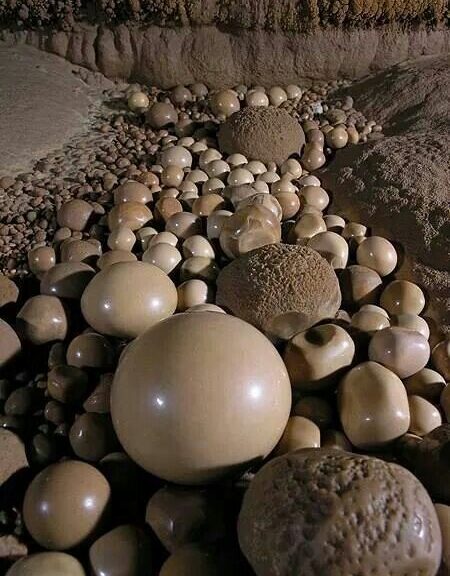
Cave pearl
Small, almost spherical concretion of calcite that is formed in a pool of water in a cave and is not attached to the surface on which it forms. Occasionally saturated water drips into small pools with such vigour that a stalagmite cannot form.
A bit of foreign matter may become coated with calcite, and slight movements of the water may keep the bit in motion while new layers of calcite are added. Concentric layers are added and polished in this way until the cave pearl becomes too large to remain in motion and becomes attached.
Cave pearls in the Pearlsian Gulf, Lechguilla Cave.
Lechuguilla cave
Cave pearls in the Pearlsian Gulf, Lechguilla Cave.
The Amazing Dinosaur Found (Accidentally) by Miners in Canada
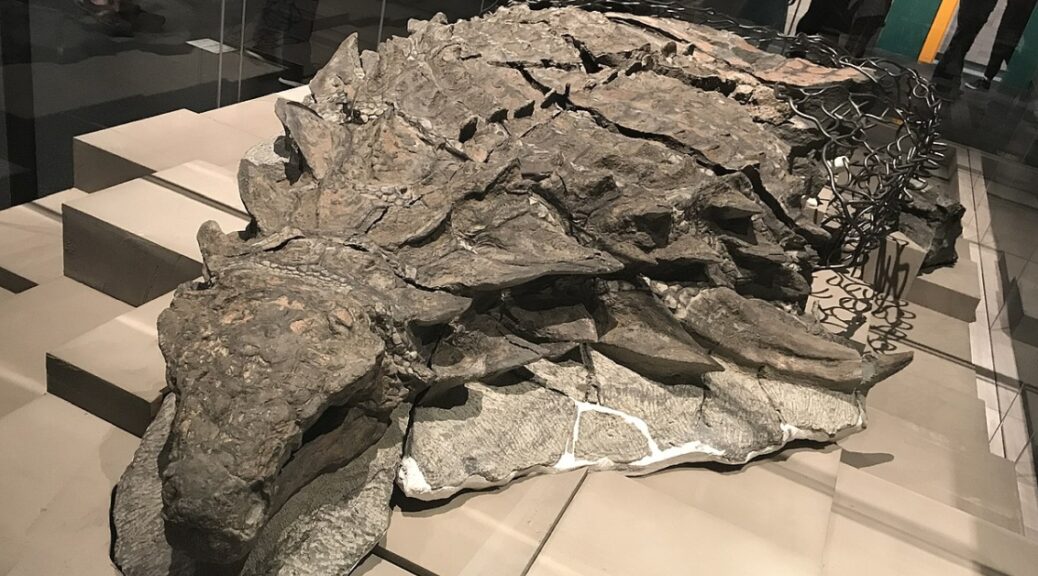
This armored plant-eater lumbered through what is now Western Canada about 110 million years ago until a flooded river swept it into the open sea. The dinosaur’s undersea burial preserved its armor in exquisite detail. Its skull still bears tile-like plates and a gray patina of fossilized skins.
A heavy equipment mechanic named Shawn Funk cut his way through the earth in the afternoon of March 21, 2011, without knowing that he would encounter a dragon soon.
That Monday had started like any other at the Millennium Mine, a vast pit some 17 miles north of Fort McMurray, Alberta, operated by energy company Suncor.
Hour after hour Funk’s towering excavator gobbled its way down to sands laced with bitumen—the transmogrified remains of marine plants and creatures that lived and died more than 110 million years ago. It was the only ancient life he regularly saw. In 12 years of digging he had stumbled across fossilized wood and the occasional petrified tree stump, but never the remains of an animal—and certainly no dinosaurs.
But around 1:30, Funk’s bucket clipped something much harder than the surrounding rock. Oddly colored lumps tumbled out of the till sliding down onto the bank below. Within minutes Funk and his supervisor, Mike Gratton, began puzzling over the walnut brown rocks. Were they strips of fossilized wood, or were they ribs? And then they turned over one of the lumps and revealed a bizarre pattern: row after row of sandy brown disks, each ringed in gunmetal gray stone.
“Right away, Mike was like, ‘We gotta get this checked out,’ ” Funk said in a 2011 interview. “It was definitely nothing we had ever seen before.”
Stretched 18 feet long and weighed nearly 3,000 pounds. Researchers suspect it initially fossilized whole, but when it was found in 2011, only the front half, from the snout to the hips, was intact enough to recover. The specimen is the best fossil of a nodosaur ever found.
A cluster of pebble-like masses may be remnants of the nodosaur’s last meal.
Royal Tyrrell Museum technician Mark Mitchell slowly frees the nodosaur’s foot and scaly footpad from the surrounding rock. Mitchell’s careful work will preserve for years to come the animal’s enigmatic features.
Nearly six years later, I’m visiting the fossil prep lab at the Royal Tyrrell Museum in the windswept badlands of Alberta. The cavernous warehouse swells with the hum of ventilation and the buzz of technicians scraping rock from the bone with needle-tipped tools resembling miniature jackhammers. But my focus rests on a 2,500-pound mass of stone in the corner.
At first glance, the reassembled gray blocks look like a nine-foot-long sculpture of a dinosaur. A bony mosaic of armor coats its neck and back, and gray circles outline individual scales. Its neck gracefully curves to the left, as if reaching toward some tasty plant. But this is no lifelike sculpture. It’s an actual dinosaur, petrified from the snout to the hips.
The more I look at it, the more mind-boggling it becomes. Fossilized remnants of skin still cover the bumpy armor plates dotting the animal’s skull. Its right forefoot lies by its side, its five digits splayed upward. I can count the scales on its sole. Caleb Brown, a postdoctoral researcher at the museum, grins at my astonishment. “We don’t just have a skeleton,” he tells me later. “We have a dinosaur as it would have been.”
During its burial at sea, the nodosaur settled onto its back, pressing the dinosaur’s skeleton into the armor and embossing it with the outlines of some bones. One ripple in the armor traces the animal’s right shoulder blade.
Paleobiologist Jakob Vinther, an expert on animal coloration from the U.K.’s University of Bristol, has studied some of the world’s best fossils for signs of the pigment melanin. But after four days of working on this one—delicately scraping off samples smaller than flecks of grated Parmesan—even he is astounded. The dinosaur is so well preserved that it “might have been walking around a couple of weeks ago,” Vinther says. “I’ve never seen anything like this.”
Shielded from Decayarmored dinosaurs’ trademark plates usually scattered early in decay, a fate that didn’t befall this nodosaur. The remarkably preserved armor will deepen scientists’ understanding of what nodosaurs looked like and how they moved.
“That was a really exciting discovery,” says Victoria Arbour, an armoured-dinosaur palaeontologist at Canada’s Royal Ontario Museum. Arbour has seen the fossil at various stages of preparation, but she’s not involved in its study. “It represents such a different environment from today and such a different time, and it has great preservation.” (Arbour has begun studying a similarly well-preserved ankylosaur found in Montana in 2014, much of which remains hidden within a 35,000-pound block of stone.
Arbour and her colleague David Evans published a description of the Montana ankylosaur, naming it Zuul crurivastator—”Zuul, destroyer of shins”—after the monster in the film Ghostbusters.)
A lucky break in the nodosaur’s left shoulder spike reveals a cross-section of its bony core. The spike’s tip was sheathed in keratin, the same material that’s in human fingernails.
The afterword of the discovery raced up the ladder at Suncor, the company quickly notified the Royal Tyrrell Museum. Henderson and Darren Tanke, one of the museum’s veteran technicians, scrambled aboard a Suncor jet and flew to Fort McMurray. Suncor excavators and museum staff chipped away at the rock in 12-hour shifts, shrouded in dust and diesel fumes.
They eventually whittled it down to a 15,000-pound rock containing the dinosaur, ready to be hoisted out of the pit. But with cameras rolling, disaster struck: As it was lifted, the rock shattered, cleaving the dinosaur into several chunks. The fossil’s partially mineralized, cakelike interior simply couldn’t support its own weight.
Tanke spent the night devising a plan to save the fossil. The next morning Suncor personnel wrapped the fragments in plaster of Paris, while Tanke and Henderson scrounged for anything to stabilize the fossil on the long drive to the museum. In lieu of timbers, the crew used plaster-soaked burlap rolled up like logs.
The MacGyver-like plan worked. Some 420 miles later the team reached the Royal Tyrrell Museum’s prep lab, where the blocks were entrusted to fossil preparator Mark Mitchell. His work on the nodosaur has required a sculptor’s touch: For more than 7,000 hours over the past five years, Mitchell has slowly exposed the fossil’s skin and bone. The painstaking process is like freeing compressed talcum powder from concrete. “You almost have to fight for every millimeter,” he says.
Mitchells fight is nearly over, but it will take years, if not decades, to fully understand the fossil he uncovers. Its skeleton, for example, remains mostly obscured in skin and armor. In some ways it’s almost too well preserved; reaching the dinosaur’s bones would require destroying its outer layers. CT scans funded by the National Geographic Society have revealed little, as the rock remains stubbornly opaque.
In May the Royal Tyrrell Museum unveils the nodosaur as the centerpiece of a new exhibit of fossils recovered from Alberta’s industrial sites. Now the public is marveling at what has wowed scientists for the past six years: an ambassador from Canada’s distant past, found in a moonscape by a man with an excavator.