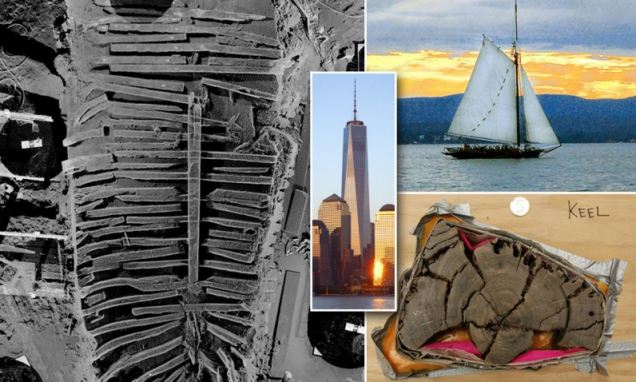
An 18th-century ship under the world trade center new york
In the midst of this tragic event and chaos, however, cleanups found something amazing in the attack on the World Trade Center (WTC), took place on 11 September 2001.
Archaeologists found the remains of a big boat’s hull underneath the ruins of the Twin Towers in 2010. Now, scientists have revealed the secrets behind this mysterious vessel.
Underneath the excavation site, the ship was found in the wreckage, some 22 feet (6.7 m) underneath the ground. By gathering samples and testing the wood from the hull of the ship, scientists were able to determine that the hull came from the same era as the Declaration of Independence, in the late 1700s.
Scientists at Columbia’s Tree Ring Lab, who were led by Dr. Martin-Benito, made this determination after comparing the wood’s ring patterns, which were found on the timber of the hull, with those found in the historical record.
The researchers used dendrochronological dating and provenancing to uncover the date of the ships’ production. More specifically, it seems that the ship was built in a Philadelphia shipyard around 1773.
Image of the Hull in the wreckage.
It also seems that the oak timbers that were used to build the ship all originated from the same general region in Philadelphia. Since the timber all comes from the same vicinity, it is likely that the ship was produced by a small shipyard.
Most notably, the researchers found that the rings on the hull match other samples that were taken from Independence Hall, which is the building where the founding fathers signed both the Declaration of Independence and the United States Constitution. In the abstract, the authors of the findings report:
After developing a 280-year long floating chronology from 19 samples of the white oak group (Quercus section Leucobalanus), we used 21 oak chronologies from the eastern United States to evaluate absolute dating and provenance.
Our results showed the highest agreement between the WTC ship chronology and two chronologies from Philadelphia (r = 0.36; t = 6.4; p < 0.001; n = 280) and eastern Pennsylvania (r = 0.35; t = 6.3; p < 0.001; n = 280). The last ring dates of the seven best-preserved samples suggest trees for the ship were felled in 1773 CE or soon after.
This finding is notable, as very few ships have been discovered from the latter decades of the 18th Century, and there is very little historical documentation related to how the ships that were produced during this year were constructed.
Consequently, this ship offers us important insights into the history of American shipbuilding.
So, how did the ship get beneath the WTC? It’s actually not as strange as you might think. When Manhattan (where the WTC was located) was first settled, the site lay within the Hudson River.
To clarify, in the 18th century, the current location of the WTC would have been underwater—beneath the Hudson.
Maps and other archival documents clearly detail this data. Obviously, as the settlement became more populated, commercial waterfront space became increasingly desirable and (consequentially) more and more scarce.
As a result, from the mid-1700s until the mid-1800s, the area along the river was increasingly filled in to advance the Manhattan coastline farther into the Hudson.
Historians still aren’t certain whether or not the ship sank accidentally, because of some unintentional mishap, or if it was purposely submerged.
Oftentimes, city planners would use garbage and other debris (like an old ship) to build the foundations of new ground in Manhattan. Essentially, we would make landfills along the Hudson in order to create a buildup that would, ultimately, increase Manhattan’s coastline.
Oysters were also found fixed to the ship’s hull, which suggests that the ship languished in the waters of the Hudson for quite some time before being buried by layers of trash and dirt that (eventually) formed the land upon which the Twin Towers rested.
It is a little ironic that the World Trade Center attack—the historic moment that reshaped much of America’s future—also opened up a door into America’s past.
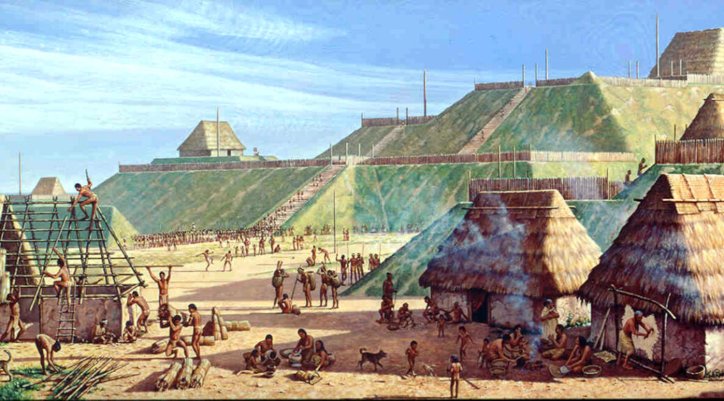
The Mystery Of Cahokia Mounds, North America’s First City
Long before Christopher Columbus “discovered” North America, the mounds of Cahokia stood tall and formed the continent’s first city in recorded history.
In fact, during its height in the 12th century, Cahokia Mounds was larger in population than London. It spread across six square miles and boasted a population of 10,000 to 20,000 people — vast figures for the time.
But Cahokia’s peak didn’t last long. And its demise remains mysterious to this day.
An illustrated aerial view of Cahokia.
The region has been occupied for the first time around 1200 BC in the late Archaic period but the first inhabitants in the area are thought to have arrived in the late woodland period around AD 600–700.
It is founded around AD 1050 in what is now western Illinois by archaeological evidence.
Cahokia at its peak was the largest urban center north of Central America’s Mesoamerican civilization with a population of 20,000 inhabitants, although the extent of the population at its highest is still disputed.
Monks Mound, the largest manmade pre-Columbian earthen mound in North America.
The city covered an area between six to nine square miles, notably larger than many contemporary European cities such as London, which during the same period was just 1.12 square miles.
The inhabitants constructed 120 earthen mounds, ranging in size and shape from raised platforms, conical, and ridge-top designs that involved moving 55 million cubic feet of earth over a period several decades.
They constructed ceremonial plazas, situated around the mounds that were interconnected with pathways, courtyards and thousands of dwellings made from wattle and daub, with outlying farming villages that supported the main urban centre.
The largest structure at Cahokia is “Monks Mound” (named after a community of Trappist monks who settled on the mound) which is a 290-metre-tall platform with four terraces that was built around AD 900–955.
An 1882 illustration of Monks Mound
The perimeter of the base of Monks Mound measures similar in size to the Great Pyramid of Giza and is notably larger than the base of the Pyramid of the Sun at Teotihuacan.
Surrounding the main precinct was a defensive wooden palisade measuring 2 miles in length with watchtowers, that was built around the year AD 1200.
Although there is no archaeological evidence of conflict, some theories suggest that the defences were built for ritual or societal separation rather than for military purposes.
Cahokia began to decline by the 13th century and was mysteriously abandoned around AD 1300-1350.
Scholars have suggested that environmental factors such as flooding, or deforestation led to an exhaustion of natural resources.
In 1982, UNESCO (the United Nations Educational, Scientific and Cultural Organisation) designated the site a World Heritage Site.
Scientists find evidence of fires built in Yucatán cave 10,000 years ago
In Mexico the oldest traces of charcoal ever discovered is found in a cenote of the Yucatán Peninsula.
Recent archeological evidence from tests of burnt charcoal has shown that the first inhabitants on the Yucatán peninsula in Mexico constructed bonfires in the cave now flooded with water for over 10,000 years.
Chemical charred samples of 14 prehistory bonfires were obtained by the scientists of the National Autonomous University of Mexico (UNAM) in 2017 and 2018 from the cenote of Aktun Ha (sinkhole) at a distance of around nine kilometers from Tulum, Quintana Roo.
In late April this year archaeologist Luis Alberto Martos López authored an article about the charcoal sample analysis which was published in the journal Geoarchaeology detailing how they had all been found in the Ancestors Chamber of the Aktun Ha cenote.
The subsequent study included controlled heating experiments, nuclear magnetic resonance spectroscopy, and carbon dating to determine the fires had burned between “10,250 and 10,750 years ago.”
Studies show that bonfires in the Aktun Ha cenote were created by a man more than 10,000 years ago.
Located beside the Tulum-Cobá highway the cenote is known locally as the “Car Wash,” for before becoming a major heritage and tourist attraction taxi drivers used to get water for washing their cars.
The dating of the fires corresponds to the early Holocene period, which is the geological epoch we are still in that began more than 11,000 years ago at the end of the last Ice Age, and the 14 charcoal remnants have been called the “oldest ever discovered in a Yucatán Peninsula cenote” according to a report in Mexico News Daily.
Mr. Martos López said this finding is helping him and his fellow scientists to reconstruct the history of fire in the Americas which he believes is of great importance for the “study of evolution and human migration.”
Before this discovery was cemented as bonafide archaeology the scientists first had to negate the possibility that waters from elsewhere had swept the charcoal remains into the cenote cave.
And increasing this possibility, in 2018, the discovery of an underground link between the Sac Actun underwater river system which is approximately 263 kilometers long, and the Dos Ojos system in Tulum which is 84 kilometers long, which Geo Mexico called “the world’s largest underwater cave system .” However, the archaeologists were able to determine that the fires had been burned locally to the cenote.
Studies show that bonfires in the Aktun Ha cenote were created by a man more than 10,000 years ago. Octavio del Río in front of the main bonfire.
Analysis of the charcoal revealed the fires had reached temperatures as high as 600 C and archaeological divers discovered stone tools and artifacts in the cave, such as hammers and scraper tools, suggesting it was a temporary shelter where butchery and cooking occurred.
But the researchers say the early hunter-gatherers who lived on the Yucatán Peninsula may have used the Ancestors Chamber “for ritual purposes”.
Describing how the ancient sacred site was accessed over 10 millennia ago, Martos explained that to get into the cave in prehistoric times people would have had to crawl through “a narrow five-meter-long tunnel whose entrance was hidden by a mound of rocks.”
At the end of the tunnel, the Ancestors Chamber of the Aktun Ha cenote measures 20 square meters high and five to six meters wide, and around 10,000 years ago a natural well-formed at the back of the cave and Martos explained that before it was flooded with water it had been “well ventilated allowing the fire smoke to escape.”
Inhabitants of the Chamber of Ancestors of the Aktun Ha cenote.
This new discovery jigsaw into the content of a Feb 2020 news article I wrote for Archaeology org about new research published in the journal PLOS One detailing the discovery of “a 9,900-year-old human skeleton,” found in the Chan Hol cave, near the Tulum archaeological site in Quintana Roo.
Belonging to a woman who had died in her 30s, the archaeologists referred to her as being among the “first people to set foot in the Americas.”
In context, when this 9,000-year-old woman sat around a fire at night considering where she might have come from, her fire burning ancestors who left the charcoal behind in the Aktun Ha cenote were as distant to her as the Norman Invasion of Britain in 1066 AD is to us, having occurred almost 1,000 before our present day.
It seems that as technologies rapidly advance, every few months archaeologists in Mexico push back the anthological clock penetrating deeper into our Ancient Origins, and very soon we may have an answer to the big question: where did the 10,000-year-old fire starters come from?
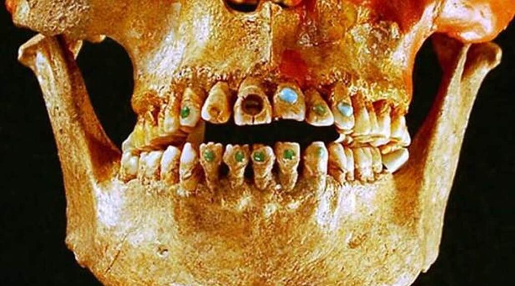
1,600-Year-Old Elongated Skull with Stone-Encrusted Teeth Found in Mexico Ruins
The 1600-year-old skeleton of an upper-class woman whose skull was purposely deformed and teeth encrusted with mineral stones was found by archeologists near ancient Teotihuacan ruins of Mexico.
Archeologists who found the 1,600-year-old skeleton near Mexico’s ancient Teotihuacan said the woman was 35-40 when she died with intentionally deformed skull and teeth encrusted with mineral stones
When she died, between the ages of 35 and 40, the woman was buried with 19 jars that served as offerings, the National Anthropology and History Institute said.
The institute said in a statement that her cranium had been elongated by being compressed in a “very extreme” manner, a technique commonly used in the southern part of Mesoamerica, not the central region where she was found.
Her teeth contained two round pyrite stones, which were encrusted in her top front teeth.
This was a practice that was used among the nobility in Maya regions in southern Mexico and Central America.
The Maya are credited with being the masters of cosmetic dentistry as they were known to decorate teeth by embedding them with precious stones or by carving notches and grooves into them.
Tiny holes were chipped out of teeth and ornamental stones—including jade—were attached with an adhesive made out of natural resins, such as plant sap, which was mixed with other chemicals and crushed bones.
The dentists likely had a sophisticated knowledge of tooth anatomy because they knew how to drill into teeth without hitting the pulp inside.
Gold studded teeth, Pre-Columbian Ecuador.
Last year, archaeologists discovered liquid mercury in a subterranean tunnel beneath the Temple of the Feathered Serpent in Teotihuacan, which may represent an underworld river that leads the way to a Royal tomb or tombs.
The remains of the kings of Teotihuacan, some of the most powerful rulers of the pre-Hispanic world, have never been found.
Such a discovery would be monumental as it would unravel many of the mysteries surrounding this ancient civilization.
The enigmatic pre-Hispanic city of Teotihuacan, some 50 kilometers (30 miles) north of Mexico City, thrived between the first and eighth centuries, after which its civilization vanished.
Its two majestic Sun and Moon pyramids are major tourist attractions.
The 1,600-year-old skeleton of an upper-class woman found near Mexico’s ancient Teotihuacan wore a prosthetic lower tooth made of a green stone known as serpentine
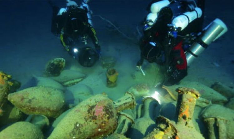
Archaeology breakthrough: How 2,000-year-old Roman shipwreck discovery ‘redefined’ history
Scuba researchers explored waters in Florida when they came across the shipwreck of a Roman vessel. The ship was called ‘Panarea III,’ and was expected to have sailed between Rome and Carthage about 218-210 AD during the Second Punic War.
In 2010 US archeologists using sonar equipment and a remotely operated submersible find it at 130 meters depth.
In the center of the researchers, the Italian archeologists considered that the ship was a supply vessel in the fleet of the Roman consul Marcus Claudius Marcellus.
Among the stunning artefacts were “small fishing plates, kalathoi, pitcher, and the louterion,” the archaeologists said.
They said the latter was probably used as a sacrificial altar on board the ship.
Jarrod Jablonski, one of the divers, added: “Metal supports still embedded in the base were likely used for fastening to the deck.
Underwater researchers were exploring waters in Florida when they came across the shipwreck of a Roman vessel.
“The Louterion (the ship) is one of many unique discoveries that promise to help redefine what we understand about ancient trade routes and commerce in the 3rd century BC.”
A similar discovery was made in the waters of the Mediterranean when a Phoenician vessel was found by researchers.
The Phoenicians were the direct descendent of the Canaanites of the south Syrian and Lebanese coast – known as a great maritime people who had developed a high level of shipbuilding technology.
It was found at a depth of 125 metres below the surface.
According to Science News, after they find, Dr. Gambin said: “This shipwreck may offer new and significant information about Phoenician seafaring and trade in the central Mediterranean during the archaic period.
“To date, little is known about the earliest contact of Phoenician mariners with the Maltese islands.”
The researchers claimed that the ship was sailing from Sicily to Malta when it sank.
It was about 15 metres long and carried a cargo of 20 grinding stones (about 35 kg each) and 50 amphorae of seven different types – indicating the ship had been indifferent harbours.
Archaeology news: They believe the ship was from Sicily
Dr. Gambin added: “This discovery may be considered as one of the best-preserved archaeological sites in Malta datable to the early Phoenician period.”
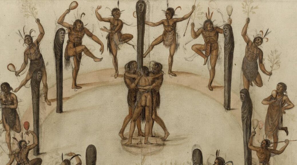
Archaeologists Have a Lot of Dates Wrong for North American Indigenous History — But Are Using New Techniques to Get It Right
It was in 1492 that Columbus reached the Americas. Many Europeans had travelled before, but the century from then until 1609 marks the creation of the modern globalized world.
It gave Europe extraordinary wealth and genocide and disease to indigenous peoples across the Americas.
The dates and the estimates of the settlement in Europe are known from texts and sometimes illustrations, to use the failed colony on what was then Virginia’s Roanoke Island as an example.
However, one thing is missing. What of indigenous history in this traumatic era? Until now, the standard timeline has derived, inevitably, from the European conquerors, even when scholars try to present an indigenous perspective.
This all happened just 400 to 500 years ago – how wrong could the conventional chronology for indigenous settlements be? Quite wrong, it turns out, based on radiocarbon dating my collaborators and I have carried out at a number of Iroquoian sites in Ontario and New York state. We’re challenging existing – and rather colonialist – assumptions and mapping out the correct time frames for when indigenous people were active in these places.
Dating Iroquoia project member Samantha Sanft excavating at White Springs, New York.
Refining Dates Based on European Goods
Archaeologists estimate when a given indigenous settlement was active based on the absence or presence of certain types of European trade goods, such as metal and glass beads. It was always approximate, but became the conventional history.
Since the first known commercial fur trading missions were in the 1580s, archaeologists date initial regular appearances of scattered European goods to 1580-1600. They call these two decades Glass Bead Period 1. We know some trade occurred before that, though, since indigenous people Cartier met in the 1530s had previously encountered Europeans, and were ready to trade with him.
Archaeologists set Glass Bead Period 2 from 1600-1630. During this time, new types of glass beads and finished metal goods were introduced, and trade was more frequent. The logic of dating based on the absence or presence of these goods would make sense if all communities had equal access to, and desire to have, such items. But these key assumptions have not been proven.
16th-century European copper alloy beads from two sites in the Mohawk Valley.
That’s why the Dating Iroquoia Project exists. Made up of researchers here at Cornell University, the University of Georgia, and the New York State Museum, we’ve used radiocarbon dating and statistical modeling to date organic materials directly associated with Iroquoian sites in New York’s Mohawk Valley and Ontario in Canada.
First we looked at two sites in Ontario: Warminster and Ball. Both are long argued to have had direct connections with Europeans. For instance, Samuel de Champlain likely stayed at the Warminster site in 1615-1616. Archaeologists have found large numbers of trade goods at both sites.
Centuries-old maize sample, ready to be radiocarbon dated.
When my colleagues and I examined and radiocarbon dated plant remains (maize, bean, plum) and a wooden post, the calendar ages we came up with are entirely consistent with historical estimates and the glass bead chronology. The three dating methods agreed, placing Ball circa 1565-1590 and Warminster circa 1590-1620.
However, the picture was quite different at several other major Iroquois sites that lack such close European connections. Our radiocarbon tests came up with substantially different date ranges compared with previous estimates that were based on the presence or absence of various European goods.
For example, the Jean-Baptiste Lainé, or Mantle, site northeast of Toronto is currently the largest and most complex Iroquoian village excavated in Ontario. Excavated between 2003–2005, archaeologists dated the site to 1500–1530 because it lacks most trade goods and had just three European-source metal objects. But our radiocarbon dating now places it between about 1586 and 1623, most likely 1599-1614. That means previous dates were off the mark by as much as 50 to 100 years.
Other sites belonging to this same ancestral Wendat community are also more recent than previously assumed. For example, a site called Draper was conventionally dated to the second half of the 1400s, but radiocarbon dating places it at least 50 years later, between 1521 and 1557. Several other Ontario Iroquoian sites lacking large trade good assemblages vary by several decades to around 50 years or so from conventional dates based on our work.
Sturt Manning examining a sample in the Cornell Tree Ring Laboratory.
My colleagues and I have also investigated a number of sites in the Mohawk Valley, in New York state. During the 16th and early 17th centuries, the Mohawk and Hudson Rivers formed a key transport route from the Atlantic coast inland for Europeans and their trade goods. Again, we found that radiocarbon dating casts doubt on the conventional time frame attributed to a number of sites in the area.
Biases That Led to Misguided Timelines
Why were some of the previous chronology wrong?
The answer seems to be that scholars viewed the topic through a pervasive colonial lens. Researchers mistakenly assumed that trade goods were equally available, and desired, all over the region, and considered all indigenous groups as the same. On the contrary, it was Wendat custom, for example, that the lineage whose members first discovered a trade route claimed rights to it. Such “ownership” could be a source of power and status. Thus it would make sense to see uneven distributions of certain trade goods, as mediated by the controlling groups. Some people were “in,” with access, and others may have been “out.”
Ethnohistoric records indicate cases of indigenous groups rejecting contact with Europeans and their goods. For example, Jesuit missionaries described an entire village no longer using French kettles because the foreigners and their goods were blamed for disease.
There are other reasons European goods do or do not show up in the archaeological record. How near or far a place was from transport routes, and local politics, both within and between groups, could play a role. Whether Europeans made direct contact, or there were only indirect links, could affect availability. Objects used and kept in settlements could also vary from those intentionally buried in cemeteries. Above all, the majority of sites are only partly investigated at best, some are as yet unknown. And sadly the archaeological record is affected by the looting and destruction of sites. Only a direct dating approach removes the Eurocentric and historical lens, allowing an independent time frame for sites and past narratives.
Dating Iroquoia Project member Megan Conger excavating at White Springs, New York. Some locations have been under-explored, so far, by archaeologists.
Effects of Re-dating Indigenous History
Apart from changing the dates for textbooks and museum displays, the re-dating of a number of Iroquoian sites raises major questions about the social, political and economic history of indigenous communities. For example, conventionally, researchers place the start of a shift to larger and fortified communities, and evidence of increased conflict, in the mid-15th century.
However, our radiocarbon dates find that some of the key sites are from a century later, dating from the mid-16th to start of the 17th centuries. The timing raises questions of whether and how early contacts with Europeans did or did not play a role. This period was also during the peak of what’s called the Little Ice Age, perhaps indicating the changes in indigenous settlements have some association with climate challenge.
Our new radiocarbon dates indicate the correct time frame; they pose, but do not answer, many other remaining questions.
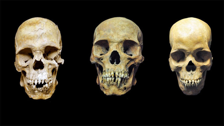
Studies of bodies buried 500 years ago in Mexico reveal stories of 3 African slaves
The men excavating a new metro line in central Mexico City stumbled on a long-lost cemetery in the late 1980s. Documents showed it had once been connected to a colonial hospital built between 1529 and 1531—only about 10 years after the Spanish conquest of Mexico—for Indigenous patients.
Three stood out as archeologists excavated the uncovered skeletons. Their teeth were filed into shapes similar to those of enslaved Africans from Portugal and people living in parts of West Africa.
Chemical and genetic studies also suggest that these people are among the first African generation to arrive in the Americas, likely as early victims of the burgeoning transatlantic slave trade.
The skulls of the men buried in Mexico City whose bodies were found in the 1990s.
Tens of thousands of slaves and free Africans lived in Mexico during the 16th and 17th centuries. Today, almost all Mexicans have little African ancestry
Rodrigo Barquera, a graduate student in archaeogenetics at the Max Planck Institute for the Science of Human History, suspected the remains might offer a window into lives often left out of historical records.
To confirm their origins, he and his adviser Johannes Krause extracted DNA and analyzed chemical isotopes, including strontium, carbon, and nitrogen, from their teeth.
Their DNA revealed that all three were men with ancestry from West Africa. (Researchers couldn’t connect them to particular countries or groups.) And the ratios of the chemicals in their teeth, which preserve a signature of the food and water they consumed as children, were consistent with West African ecosystems, the researchers report today in Current Biology.
“It’s really nice to see how well the different lines of evidence come together,” says Anne Stone, an anthropological geneticist at Arizona State University, Tempe, who wasn’t involved with the research.
All three skeletons, now at the National School of Anthropology and History in Mexico City, show signs of trauma and violence.
Remains of the three men show signs of physical abuse, such as the green stains produced by a gunshot wound.
The men were likely in their late 20s or early 30s when they died. Before that, one man survived several gunshot wounds, and he and another man showed a thinning of their skull bones associated with malnutrition and anemia.
The third man’s skeleton showed signatures of stress from grueling physical labor, including a poorly healed broken leg. These signs of abuse make it likely that the men were enslaved rather than free, Krause says.
The two men with malnutrition also carried pathogens linked to chronic diseases, according to a genetic analysis of the microbes preserved in their teeth.
One had the hepatitis B virus, and the other carried the bacterium that causes yaws, a disease in the same family as syphilis.
Both microbes were most closely related to African strains, making it likely the men caught these pathogens in Africa. Or perhaps they picked up the microbes on an overcrowded slave ship voyaging to the Americas, suggests Ayana Omilade Flewellen, an archaeologist at the University of California, Berkeley, who studies the experiences of enslaved Africans and wasn’t involved in the study.
Such journeys killed millions between the 16th and 19th centuries. Either way, this is direct evidence that the transatlantic slave trade introduced novel pathogens to the Americas, Krause says, just as European colonization did.
The three men survived all these hardships. In fact, researchers still aren’t sure what killed them.
They were buried in a mass grave in the hospital’s cemetery that could be linked to an epidemic, perhaps of smallpox or measles. But researchers didn’t find DNA from deadly infectious diseases in their remains.
The men’s presence in a hospital for Indigenous people highlights the largely forgotten diversity of early colonies in the Americas, Flewellen says. “We need to break out of the binary of just Native [American] and European experiences” and remember that Africans were part of the story as well.
Thousands of ancestors’ remains, sacred objects to return home to North Dakota tribe
In a storage room at the University of Tennessee’s anthropology department, the remains of almost 2,000 Arikara and Mandan people rest in boxes, alongside the sacred objects buried with them centuries ago.
There, 65-year-old Pete Coffey, director of the Tribal Historic Preservation Office for the Mandan, Hidatsa, and Arikara Nation, reunited with his ancestors in 2017.
“The only thing I can tell you is that I felt the presence of those ancestral spirits very strongly when I walked in there,” he said.
The Native American remains stored there were buried centuries ago along the Missouri River in South Dakota, according to a Federal Register report published in November. The 1,971 ancestors and 2,263 funerary objects have been traced to the Arikara and Mandan, who once lived in earth lodges along the river. The tribes, along with the Hidatsa, now live west of there on the Fort Berthold Reservation in North Dakota.
In the mid-1900s, archaeologists excavated the burial sites along the Missouri River in South Dakota as part of the Smithsonian’s River Basin Survey. The survey was an effort to gather as much archaeological information as possible before dams and reservoirs flooded areas along the Missouri River following the 1944 Flood Control Act.
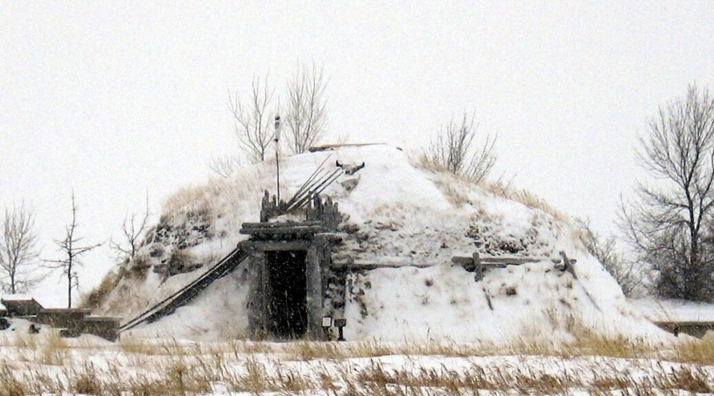
An authentic reproduction of a Mandan Hidatsa earth lodge sits next to the Knife River Indian Villages interpretive center in North Dakota
For the MHA Nation, that meant thousands of their ancestors were taken out of the ground. An archaeologist who helped excavate the remains eventually transported them to the University of Tennessee, where they’ve been stored since before the Native American Graves Protection and Repatriation Act (NAGPRA) was passed in 1990. The act asked federal agencies and museums to take inventory of Native American remains and funerary and sacred objects in their possession and to work with tribes who have a claim to return the remains.
Coffey said NAGPRA gave tribes “the right to repatriate these remains which were taken with no thought of human decency, either by collectors or by archaeologists from museums and put on display.”
Coffey has been working with universities and museums across the U.S. that have reached out since the act was passed in the hopes of returning remains. Still, the MHA Nation is just one of the hundreds of tribal nations across the country working to reclaim their ancestors since the act was passed. The Federal Register regularly posts reports alerting tribes to collections.
Dustin Lloyd, the burial coordinator for the South Dakota State Historical Society’s Archaeological Research Center, said some members of the scientific community worried about losing data or information from burial grounds after the act was passed. But Lloyd said the issue is more human than that.
“These were people at one point,” he said. “They were family members, they were fathers, sons, grandmothers. That’s why protection in place is such an important aspect of NAGPRA.”
Reburial this summer
Since 1990, Coffey has helped reclaim tens of thousands of his Mandan, Hidatsa, and Arikara ancestors across the country. When remains are returned, he consults with tribal elders to determine where and how they should be buried. He said, for the most part, remains are simply put back into the ground, as all the prayers and ceremonies were performed at the original time of burial.
Sometimes, remains are returned to the sites near where they were originally taken. But when that’s not feasible, Coffey said, the remains are repatriated, or given back, to the tribe for reburial on their land.
This summer, the MHA Nation will rebury thousands more of their ancestors. Ellen Lofaro and Robert Hinde at the University of Tennessee started working on the repatriation of remains in 2016 and 2017, respectively. Lofaro, a curator of archaeology, said NAGPRA “not only gives tribes a voice at the table but a power to make decisions. Archaeologists did not always take their wishes and desires into consideration.”
The university contacted the MHA Nation to let them know they had thousands of remains and funerary objects in storage. The next year, 2017, Coffey came to see the remains for himself.
The university, the tribes, and the Army Corps of Engineers for the Omaha District — which owns the land where the remains were excavated — had to meet to determine how to proceed according to NAGPRA rules.
“We’re pretty grateful NAGPRA has a process we feel is successful in helping get these ancestors back to their families,” said Julie Jacobsen, cultural resources program manager for the Corps’ Omaha District.
Because the Corps is the largest land management agency in the U.S., they have “a lot of land with a lot of sites” where collections were excavated prior to NAGPRA. Making sure these collections are properly cared for by those managing them and working to get them repatriated is a “big responsibility,” Jacobsen said. She added that the collection at the University of Tennessee is abnormally large compared to most the Corps works to repatriate.
Overall, Coffey said working with the university and the Corps to repatriate the remains has been a very positive experience.
Jacobsen said the Corps is working to determine how many trailers will be needed to safely return the remains and sacred objects to the MHA Nation and to devise a security plan to protect the remains during the long drive from Tennessee to Fort Berthold.
Hinde said the remains are set to be transported home this summer when cold weather isn’t a factor. There, at Fort Berthold, the tribal ancestors will be laid back to rest.