Category Archives: NORTH AMERICA

A Lowa teenager searching for Arrowheads finds a 30,000-year-old mastodon jawbone instead

A Lowa teenager searching for Arrowheads finds a 30,000-year-old mastodon jawbone instead

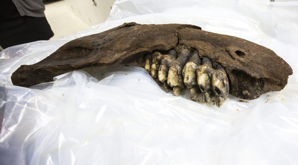
When hunting for arrowheads on an Iowa farm a teenager got a huge surprise. Instead of any arrowheads, the teen found a 30-inch jaw bone of a mastodon — a prehistoric hairy elephant, related to the mammoth. 

According to WHO-TV, a paleontology unit at the University of Iowa (UI) retrieved the jaw bone and other associated bones over the weekend.

“A few weeks ago we were informed that someone had discovered a fossil on the property in the middle of a small field,” Tiffany Adrain, head of the UI Paleontology Repository told the media.

A University of Iowa paleontology team was on a farm in southern Iowa to pick up the bone of a prehistoric mastodon.​

Facts About Mastodons

Appearance

Unlike modern elephants, mastodons had much smaller ears and foreheads and were covered in a thick layer of brown hair. Hairs on their coats could grow up to 35 inches (90 centimeters) and the males’ tusks grew to about 8 feet (2.5 meters). Females did not have tusks.

From foot to shoulder, mastodons were between 8 and 10 feet (2.5 and 3 m) tall. They weighed between 4 and 6 tons (3,500 and 5,400 kilograms), according to the Illinois State Museum.

That isn’t much different from their modern counterparts. Modern elephants weigh 3 to 7 tons (2,722 to 6,350 kg) and range from 5 to 14 feet (1.5 to 4.3 m) tall, according to The Defenders of Wildlife. 

Habitat

Though mastodons appeared primarily in North and Central America, they eventually spread all over the world, in every continent except for Antarctica and Australia. They typically inhabited spruce woodlands around valleys and swamps, according to Cochise College. 

Extinction

Mastodons went extinct around 10,000 years ago. There are many theories as to why. Most of these theories boil down to climate change and/or human hunting, according to Simon Fraser University.

Some scientists think that the Earth warmed up from the Ice Age too quickly for the mastodon to adapt or that humans hunted them to extinction.  

Others, like researchers Bruce Rothschild of the Northeastern Ohio Universities College of Medicine and Richard Laub of the Buffalo Museum of Science in New York, have a different theory.

They found that 52 percent of the 113 mastodons they studied had signs of tuberculosis. This led the researchers to think that a tuberculosis pandemic contributed to their extinction.

Though death by disease sounds like a cut-and-dry answer, “Extinction is usually not a one-phenomenon event,” Rothschild told Live Science.

It is likely that the disease didn’t kill off the animals directly, but made them weak. Coupled with the coming out of the Ice Age and fighting off humans, the species just couldn’t survive. 

Sculptures by artist Sergio de la Rosa show three elephant relatives, from left to right: the mastodon, the mammoth and the gomphothere.

Fossil discoveries 

The first mastodon fossils were found in 1705, according to the Oregon History Project, when a large tooth and bone fragments were found in the Hudson River Valley in New York.

Not long after, in 1807, Thomas Jefferson personally financed an expedition that was by led William Clark to excavate mastodon and mammoth fossils from the Big Bone Lick site in Kentucky.

There have been many mastodon fossil discoveries in the past few hundred years. Sometimes, they are found in unusual places. For example, on October 16, 1963, Marshal Erb was using a dragline to excavate a pond and found fossils that came to be known as the Perry Mastodon. In another instance in 2016, a sinkhole in Florida’s Aucilla River was declared an “archaeological gold mine” after an ancient human tool and mastodon bones are found inside.

“It was actually a high school student who had found the object, and the landowners contacted us and notified us [and] sent us photographs. Now we could tell right away it was a jaw bone of a mastodon,” she added.

The bone, which was then donated by the farmers to the UI Paleontology Repository, is believed to have belonged to a young mastodon that might have been 7-feet tall, the Iowa City Press-Citizen reported.

The couple who own the farm and donated the bones asked not to be named so that fossil hunters don’t trespass on their property. About 30 years ago, they had found other bones on their land that belonged to a woolly mammoth, WHOTV reported.

“I think people are finding stuff all the time,” Adrain told the Press-Citizen. “Maybe they are out canoeing or fishing on a bank. Farmers, in particular, on the land can spot things pretty easily.”

Scientists uncover a 60,000-year-old forest underwater and think its preserved trees may help pioneer new medicines

Scientists uncover a 60,000-year-old forest underwater and think its preserved trees may help pioneer new medicines

Roughly 60,000 years ago, pre-historic human beings started to migrate from Africa and shared hunting places and cave residences with Neanderthal populations in what is today Europe. 

Meanwhile, on the other side of the world, a vast cypress tree forest carpeted riverbanks off the coast of Alabama in Mobile Bay in the Gulf of Mexico.

In 2004, Hurricane Ivan ripped up the Gulf Coast and revealed the ancient forest, which was found 60 feet below the surface water of Mobile Bay, the ancient underwater forest of withering trees and the shipworms they produce is buried under invasive sediments and sea waters.

The Ancient Secrets of Modern Medicine

A recent Ben Raines documentary film produced by This is Alabama reveals how dive shop owner Chas Broughton first discovered evidence of the ancient forest and invited an environmental journalist and scientists from the National Oceanic & Atmospheric Administration ( NOAA) to assess his find.

The results were published on the NOAA Ocean Exploration & Research website, saying this ancient submerged forest has remained undisturbed for thousands of years and that it holds “the secret to the creation of new medicines .”

A report in Nature World News says Dr. Kristine DeLong from the Louisiana State University (LSU); marine scientist Robin Cobb from LSU; and Dr. Grant Harley, a dendrochronologist from the University of Southern Mississippi collected and analyzed tree samples to determine the type of marine environment in which the forest had been entombed, and what the climatological conditions were like when the forest was alive.

300 Ancient Animals Found Entombed in Submerged Forest

A sample of tree sap was recovered from within the bark of one tree, that when cut released resin strong enough to “permeate the air” and the tree’s fibers and growth rings were still visible.

Dr. Harley said the tree’s growth rings were narrower and were more uniform in size than those of modern cypress trees, indicating the environment was much colder than our current climate, and Dr. DeLong radiocarbon-dated the sample at 40,000-45,000 years old.

Collected from an ancient cypress forest submerged in Mobile Bay, this log contains hundreds of marine organisms that either burrow into the wood or live in burrows made by other organisms.

Last December, NOAA-funded an expedition of scientists from the University of Utah and Northeastern University, and marine and environmental sciences professor Brian Helmuth, who determined that the ancient trees were very well preserved under sediment layers that had prevented oxygenation and decomposition.

It was Francis Choi, a senior lab manager at Northeastern University Marine Science Center, who looked at organisms buried within the wood and discovered 300 ancient animals.

This dried specimen of Teredo navalis was extracted from the wood and the calcareous tunnel that originally surrounded it and curled into a circle during preservation. The two valves of the shell are the white structures at the anterior end; they are used to dig the tunnel in the wood.

The Anti-Viral Property of Ancient Shipworms

Sometimes called “termites of the sea,” shipworms are tiny marine bivalve mollusks(saltwater clams) with long, soft, naked bodies, and they are notorious for boring into wood immersed in sea water. As these worms bore their way into organic matter, what comes out the other end is converted into animal tissue.

In this study, one hundred bacterial strains from shipworms, many of which were novel, were dated to being at least 60,000 years old.

The team of scientists DNA-sequenced 12 of the strains, determining that they could be applied in the creation of new antibiotics for treatment against “parasites, pain and anti-cancer drugs, antimicrobial activity, and possibly anti-viral drugs”, according to University of Utah medicinal chemistry research professor Margo Haygood.

Ocean Genome Legacy Center Director Dan Distel removes a shipworm. The bacteria that shipworms create may lead to new life-saving medicines.

This is not the first time scientists have studied shipworms in a medical context, in 2017 a paper by Northeastern University scientists titled “’Unicorn’ shipworm could reveal clues about human medicine, bacterial infections” was published by Science Daily.

Researchers discovered a “dark slithering creature four feet long” dwelling in foul mud in a remote Philippines lagoon and this “giant shipworm”, with pinkish siphons at one end and an eyeless head at the other was said to have added to the scientific understanding of how “bacteria cause infections and, in turn, how we might adapt to tolerate, and even benefit from them.”

Modern Virus Halts Research on Ancient Anti-Virus

According to East Idaho News, the COVID-19 pandemic has put a stop to diving at the ancient forest site in the Gulf of Mexico, but Dr. Choi and his team plan to launch unmanned underwater robots to provide 3D visualizations of the forest and Dr. Haygood and her team plan to study more tree samples next year, which NOAA said might have applications in “textile, paper, food, renewable fuel, animal feed, and fine chemical production.”

Archaeological Sites Investigated in Northern Alaska

Archaeological Sites Investigated in Northern Alaska

Archaeologist Jeff Rasic of the National Park Service has investigated archaeological sites at Howard’s Pass, a several miles–wide tundra plateau located in the mountains of northern Alaska’s Brooks Range.

A National Park Service climate-observing station in Howard Pass, a broad crossing of the Brooks Range between Alaska’s North Slope and the Noatak River drainage.

The sites date back some 11,000 years and include traces of houses, tent rings, food-storage pits, tool-making debris, and cairns that may have been used to help drive caribou into hunting traps. 

Jeff Rasic is an archaeologist for the National Park Service who has sifted through wet soil near Howard Pass. The pass, named for U.S. Navy explorer William Howard (who traversed it during an expedition on April 21, 1886), is more than 100 miles from the closest villages today, Ambler and Kobuk, both to the south.

Howard Pass was not so quiet over the past 11,000 years. In the area, archaeologists have found hundreds of house remains, tent rings, food-storage pits, scattered stone chips from tool makers and cairns that resembled humans to help drive caribou into traps.

“People took advantage of caribou, fish, muskox, berries, waterfowl — and in the earliest period, probably bison,” Rasic wrote about Howard Pass, a tundra bench several miles wide that caribou from the Western Arctic herd still click through during seasonal migrations.

This food-rich area has another side to its character. Howard Pass’s Inupiaq name is Akutuq, a word for a treat made of whipped animal fat, sugar, and berries. Natives gave the pass that name because the wind-tortured snow patterns there reminded them of akutuq.

National Park Service scientists in 2011 installed a rugged weather station at Howard Pass as one of 50 similar climate stations in hard-to-reach parklands across Alaska. The stations are battery and solar-powered and send their data in blips to orbiting satellites.

That information has included — on Feb. 21, 2013 — a wind-chill temperature of minus 96.9 degrees Fahrenheit. The air temperature that day was minus 45.5 degrees F. The wind blew at a sustained 54 miles per hour.

“This was not an isolated event,” Pam Sousanes of the National Park Service said of the Howard Pass windchill. “Similar conditions have been recorded in 2014, 2015, 2016 and 2017.”

The average wind chill for Feb. 12-16, 2014, was minus 84.5 degrees F when the highest wind gust through the pass was 103 miles per hour. Wind chills of minus 70 or lower have been recorded each year.

This low spot in the western Brooks Range becomes a wind tunnel when there a great atmospheric-pressure difference that exists between Alaska’s North Slope and the rest of the state. Cold air from the north rips southward though the pass.

“The wind chill can be so severe as to freeze to death caribou caught there by a winter storm,” wrote Ernest Burch in the book “Alliance and Conflict: The World System of the Inupiaq Eskimos.” “After every bad blow, the Eskimos used to go into the pass to look for well-preserved caribou carcasses.”

Sousanes and her colleague Ken Hill have replaced the wind monitor on the Howard Pass station every year; the steel mast that holds it up is pocked by rocks and ice.

Minus 100 degrees does not seem to mesh with human occupation; nor does a place with no firewood.

However, not only is the pass loaded with archaeological sites, a few of them are winter dwellings, Rasic said, with half the living area underground and featuring cold-trap tunnels at the entrances.

Why might people have chosen a spot with such inhumane conditions?

“It’s a reliable place to harvest caribou, and there are lakes with fish,” Rasic said. “If you are someone trying to escape clouds of mosquitoes, winds aren’t necessarily bad. And maybe a windswept place is good for winter travel — hard and crusty, good to get around on.”

Kansas Archaeologist Rediscovers Lost Native American City

Kansas Archaeologist Rediscovers Lost Native American City

A conqueror named Juan de Oñate led an expedition of 200 soldiers in 1601 into uncharted territories of what is today the state of Kansas.

Along with the soldiers and canons, the group was accompanied by a number of priests as well as adventurers who were attracted by the expedition’s final goal ― the legendary city of Quivira, whose streets were allegedly paved with gold.

Before Oñate chose to venture into the Great Plains, two other conquistadors ― Antonio Gutiérrez de Humana and Francisco Leyva de Bonilla ― already lost their lives there in 1594, while embarking on a similar quest.

Juan de Oñate, first Governor of New Spain.

But Oñate’s thirst for fame and riches, as well as an appetite for terror, led him and his posse deep into the unknown where he indeed discovered a large settlement, but it wasn’t exactly what he expected.

More than 400 years later, archaeologists from the Wichita State University flocked around a site which they believe was the place where Oñate found his Quivira, or Etzanoa, as it was known to the Native Americans.

Oñate’s 1605 “signature graffiti” on Inscription Rock, in El Morro National Monument.

Located in southern Kansas, at the confluence of the Walnut and the Arkansas rivers, it has been known for decades as a place of historical findings. Since 1959, both archaeologists and locals have discovered various artifacts belonging to the Wichita people.

Literally tons of objects belonging to an ancient civilization were collected after a road construction in 1994. Many of the objects are kept in private property, as it became common to find shards of pottery or pieces of arrowheads. However, never before was the connection made between these traces of settlement with the almost mythical city of Etzanoa ― discovered by Oñate’s expedition in 1601.

Trade beads found at a Wichita village site, c. 1740, collection of the Oklahoma History Center.
Protohistoric Wichita points found at Etzanoa.

The research was conducted under the supervision of Donald Blakeslee, a veteran archaeologist who became intrigued with finding the lost city in 2013, after new translations of various accounts of Spanish colonialists serving under Oñate during the Etzanoa expedition were made by scholars from UC Berkeley.

Together with the National Park Service, Blakeslee scanned the area with a magnetometer, enabling him to determine the variations in the earth’s magnetic field and locate remains of houses, cellars, and fireplaces belonging to a once vibrant settlement. Not far from the settlement’s location, in what is today a suburb of Arkansas City, traces of battle were also found, including three Spanish cannonballs, a horseshoe, and a number of other objects.

Protohistoric Wichita stone knives were recovered from the site by the Kansas State Historical Society.

Let’s head back to the year 1601 and the fate of Juan de Oñate’s expedition, to further unravel the story which led to this amazing discovery. After his vanguard came with reports that a large settlement lay ahead of them, the conquistador must have rubbed his hands in delight ― it was the chance to amass gold, and to convert the natives into Christianity, gaining favor from the Spanish Crown in return.

According to his scouts’ reports, the city seemed as though it stretched for miles. Large beehive-shaped houses with thatched roofs and fields of corn, squash, and beans overtook the horizon. Their estimate was that there must have been more than 20,000 people living there.

A sketch of a Wichita Indian village in the 19th century. The beehive-shaped grass-thatched houses surrounded by cornfields are characteristic and appear similar to those described by Coronado in 1541.
Esadowa (or Isadowa) was chief of the Wichita village adjacent to the Comanche camp attacked by Van Dorn in 1858. In 1861, Esadowa led his people north to Kansas, then in 1865 brought them back to the Indian Territory.

After they were approached by a friendly delegation bringing offerings, the Spanish took the welcoming committee as hostages, as they needed leverage while possibly facing an entire city in battle. As a response, Wichita warriors, who were calling for a fight with the invaders, put on their battle paint. Spanish soldiers named them Rayados ― due to tattoos and paint they wore on their faces and bodies.

Even though at one moment it looked as though they were going to face an army eager to fight, only a handful of people were found in the city as the conquistadors marched into it. The inhabitants of Etzanoa, perhaps familiar with the stories of vicious invaders and their firepower, decided it was safer to just evacuate the entire city for a while than to battle the treacherous Spaniards.

So when the conquistadors entered the city, it was already empty. They wandered the city for several days in their search for gold, counting more than 2,000 houses, all of which were big enough for 10 people.

Adam Ziegler holds an iron ball that he found with a metal detector. The ball, which was part of a cartridge load for a cannon, was the first piece of evidence that suggested the archaeologist had located the battlefield where the Spanish fought the Native Americans.

Once they decided to leave, however, they were met with a horde of 1,500 warriors belonging to the Escanxaques tribe, which rivaled the Wichita. Apparently, they were on a warpath, but instead of fighting their historical enemies, they ended up battling a small detachment of Spaniards who attempted to break through using cannons and muskets. By sheer luck alone, the conquistadors managed to withdraw from the battlefield, suffering heavy casualties.

Afterward, the accounts of their mishaps have often been discarded as exaggerated ramblings of adventurers who sought glory or support from the Spanish Crown. Modern historians dismissed the notion of a settlement of such scale, in part because of yet another expedition, this time under French leadership, that ventured into the same area around 100 years later, only to find what looked to them like untouched nature.

It is most likely that the settlement was abandoned and left to waste due to some sort of disease epidemic, which was the most common reason for the extinction of many other Native American cultures. Thanks to Blakeslee and his team, a real breakthrough is happening, as Etzanoa is estimated to be the second-largest ancient settlement in the United States, the first one being Cahokia in Illinois.

Researchers conducting a surface survey mark the locations of stone flakes, points, and tools with brightly colored flags.

The discovery is also reshaping the way that the history of Great Plains tribes is perceived. It was mostly believed that the tribes inhabiting North America lived in rural settlements or as nomads, as opposed to the vast cities of the Mayans and Incas in the south. However, the unearthing of Etzanoa goes to show that large urban areas existed and thrived as trade centers of civilizations long gone.

According to Jay Warren, an Arkansas City council member, plans are already put in motion to turn the site into a tourist attraction.

“We’re not talking about putting together a one-day wonder. We’re looking at creating something that could be great for the region, and for 50 years and more down the road. We’re talking with (Unified School District) 470 about how it could enhance education. And we think the site could also be a hands-on field training facility for archaeologists from all over the world.”

A gigantic natural quartz crystal cluster was mined from the Colemans quartz mine near Jessieville

A gigantic natural quartz crystal cluster was mined from the Colemans quartz mine near Jessieville

On a Reddit site on Sunday, almost two years after it was found in the Arkansas mine, a picture of 3.5 million dollars chunk of quartz was taken.

Ron Coleman left, and his son Josh Coleman, right, found an 8-foot, 2,000-pound crystal while digging at a mine in Jessieville

This mine was and is the most productive quartz mine in Arkansas. It has been producing quartz crystals in large quantities since 1943. When it is operating it has produced about 60,000 pounds of quartz crystals during a good month.

The image shows a man posing with an 8-foot block of crystals found in the Ron Coleman Mine in Jessieville, about 30 minutes north of Hot Springs.

The man pictured was not a visitor to the mine, which is open year-around for public digging, but an employee who worked on a team to extract the mineral over a four-day excavation said Joel Ledbetter, an online marketer for Ron Coleman Mining.

A $3.5 million chunk of quartz found in Arkansas was featured on the Reddit home page Sunday.

A $3.5 million chunk of quartz found in Arkansas was featured on the Reddit home page Sunday.

“We had a good guess it was there because there’s a 170-mile quartz vein that runs through Arkansas, so we started digging,” Ledbetter said.

Crews blasted the area until they found the vein and then used hand tools to dig out the 2,000-pound chunk that machines lifted out of the mine.

The crystal cluster is one of the most impressive pieces to come out of the quarry since people started digging before World War II — in part to retrieve crystals used in early radios, Ledbetter said.

The 8-foot, 2,000-pound crystal cluster found at the Ron Coleman mine is being kept at the quarry until a buyer is found.

The 8-foot, 2,000-pound crystal cluster found at the Ron Coleman mine is being kept at the quarry until a buyer is found.

The latest find is second in size to only a 9-foot, a 3,000-pound circular formation that was found in the mine just a year or two before.

While the larger piece is on display at various trade shows in Arizona, the other remains in Jessieville until it can be sold.

Ledbetter said several people have inquired about the $3.5 million crystal cluster, but the company has not yet found the right buyer.

That may change as the photo gains popularity as it spreads among various social media platforms.

“Someone really big into crystals probably shared it, and other people who hadn’t seen it saw it and got excited about it,” Ledbetter said. “Anytime people talk about mine, it’s good publicity. People get into crystals but don’t necessarily get to see all that comes out of here.”

Underwater Artifacts Returned to Mexico’s Lake of the Moon

Underwater Artifacts Returned to Mexico’s Lake of the Moon

A collection of objects preserved in a special container at the bottom of Lake of The Moon at high altitudes in the Nevado de Toluca Volcano in Central Mexico was deposited by Mexico’s National Institute for Anthropology and History (INAH).

Underwater archaeologist Roberto Junco deposits the archive on the bottom of the Lake of the Moon.

The artifacts were found in the lake in 2007 and kept in the last 13 years during the research under similar underwater environments.

52 pre-Hispanic ritual items returned to their site by underwater archaeologists where they were found, the bed of one of the two crater lakes of the Nevado de Toluca volcano.

Members of the underwater archaeology team at the National Institute of Anthropology and History (INAH) deposited the mostly spherical and conical resin objects on the bed of the Lake of the Moon earlier this month.

The objects, believed to have been made by the Matlatzinca people between the 13th and 15th centuries and placed in the lake by pre-Hispanic priests, are stored in a specially-made container that allows water and sediment to flow over them. As a result, they are protected from deterioration.

The trove of objects is the first in situ underwater archaeological archive in Mexico, according to an INAH statement.

The decision to preserve the objects in their place of origin complies with recommendations in the 2001 UNESCO Convention on the Protection of the Underwater Cultural Heritage.

The objects were found at the Nevado de Toluca crater lake in 2007 and have been studied and analyzed for the past 13 years.

Enna Llabrés and Roberto Junco prepare the collection of artifacts for a deposit on the lake bottom.

Enna Llabrés Torres, a researcher with the INAH underwater archaeology department who made the container in which the resin relics are stored, said that the objects could be removed for further study in the future as new technologies and methods of analysis emerge.

She explained that while the objects were studied over the past 13 years, they were stored underwater in conditions similar to those found at the Lake of the Moon, which is located more than 4,000 meters above sea level and has an average temperature of 3 C.

The conical objects measure 20-30 centimeters while the spherical ones are roughly the size of a baseball. INAH archaeologist Iris Hernández said that the Nevado de Toluca volcano has been considered a sacred site since pre-Hispanic times and for that reason, relics used in rituals and ceremonies have been found there.

She said that the conical objects – made out of resin of the copal tree – may have been specifically made to resemble the form of the volcano, located in modern-day México state.

According to carbon dating tests conducted by experts at the National Autonomous University Institute of Physics, the ritual objects date back to between 1216 and 1445 AD.

The time period corresponds to the rule of the Matlatzinca people in the Valley of Toluca prior to their domination by the Mexicas.

The life and death of one of America’s most mysterious trees

The life and death of one of America’s most mysterious trees

In the Centre of Chaco Canyon in New Mexico, a towering ponderous tree, known as the “Plaza Tree,” was once built to be a symbol of life and a center of the world for an ancient pueblo town. But new research suggests it may have been just a giant log no one bothered to move for 800 years, and maybe didn’t hold significant meaning. 

The “Plaza Tree of Pueblo Bonito” was thought to be a living “world tree” for ancestral Puebloans. But researchers have found that it grew 50 miles away and was dead when it was hauled there.

“I believe the tree was dead when it had been taken into the canyon,” said Chris Guiterman, a research assistant scientist studying ancient trees at the Tucson University of Arizona.

For over a hundred years, people assumed the tree had meaning; it was regarded as a “tree of life”, according to one researcher, or a “world tree.” The solitary tree was once thought to represent the living “center of the world” for the people of Pueblo Bonito, the largest of Chaco Canyon’s “great houses,” which was occupied between A.D. 850 and 1150.

Some speculations placed the tree at the center of a religious cult, and an illustration of a growing “Plaza Tree of Pueblo Bonito” appears in a brochure from the National Park Service.

Guiterman and his colleagues discovered that the Plaza Tree probably didn’t grow at Chaco Canyon, but more than 50 miles (80 kilometers) away. They also found no evidence that the tree had a religious role — it might have been a pole, or a beam for a house, or firewood.

“I actually have no idea whether it did, does, or ever had religious significance,” Guiterman told Live Science in an email. “I don’t know what it was used for, or why it was located in the plaza where it was found.”

Pueblo Bonito is the largest of the adobe “great houses” in Chaco Canyon. It was occupied between 850 and 1158 AD and is considered the center of the Chaco world.

“Tree of life”

The researchers studied three aspects of the Plaza Tree: documents about the discovery of its 20 foot (6 meters) long trunk in Pueblo Bonito in 1924; the levels of isotopes of the chemical element strontium within samples of its wood, which can identify where it came from; and the width of its tree rings, which can show seasonal growth.

Ideally, the tree rings would have been compared to rings from trees of the same age, wrote the researchers in the study, published online March 13 in the journal American Antiquity — but that wasn’t possible, so they used the rings in modern trees to determine distinctive growth patterns based on the climate of particular areas.

The researchers found that the tree ring width and the strontium isotopes of the Plaza Tree didn’t match those of ponderosa pine trees that grew around Chaco Canyon — instead, they closely matched trees that grew in the Chuska Mountains, about 50 miles (80 kilometers) west.

The Chuska Mountains region “also happens to be the primary source for architectural wood used to construct Pueblo Bonito and other Chaco great houses,” Guiterman said.

The researchers determined that archaeologist Neil Judd of the Smithsonian Institution, who excavated Pueblo Bonito in the 1920s, failed to find any sign of deep roots from the tree in the plaza where it was found, and initially dismissed the idea that it had been growing there.

But Judd’s dismissal seems to have been overlooked in his following interpretation in the 1950s when he described the Plaza Tree as the last living remnant of an ancient forest that once existed at Chaco Canyon.

The researchers studied the width of the ancient tree rings and their levels of isotopes of strontium in the wood of the Plaza Tree to determine how old it was and where it came from.

Ancient pueblos

Recent research has shown that logs were often hauled for dozens of miles to build the pueblos at Chaco Canyon, Guiterman said: “hundreds of thousands of timbers were used in the construction of [the] great house structures.”

The Plaza Tree is one of only two logs found in an ancestral Puebloan structure that were not parts of buildings. The other is a 32 foot (10 m) long log of white fir at the Kiet Siel cliff dwelling in Arizona, discovered in the 1890s. That unexpected find may have prompted Judd’s more elaborate interpretation of the Plaza Tree, Guiterman said.

“It was a puzzling discovery — one of a kind, really,” he said. “It served as evidence for an early idea that Chaco Canyon was heavily forested before the great houses were constructed, and that the hundreds of thousands of beams came from that local forest.”

The researchers looked again at several theories surrounding the Plaza Tree, including that it served as a gnomon — the upright that casts a shadow — of an ancient sundial. “Although we cannot confirm that [the Plaza Tree] was actually long enough to be a gnomon, it is certainly possible,” they wrote.

The tree may also have served as an upright pole in ceremonies and festivals, such as the pole-climbing that features in some Native American festivals and which may have originated in ancient Mesoamerica, the researchers wrote. The branches and logs of pine trees are used in some Puebloan ceremonies today. 

But the Plaza Tree also could have had a much more mundane use. “It might have been a log staged for construction of a new room, or to replace a damaged beam in an existing room,” they wrote. “It could have been a bench, or intended for fuelwood [firewood].”

Gold bar found beneath Mexico City street was part of Moctezuma’s treasure

Gold bar found beneath Mexico City street was part of Moctezuma’s treasure

A recent scientific study of a large gold bar discovered in the city center of Mexico City decades ago shows that it was part of the plunder Spanish conquerors tried to carry away as they fled the Aztec capital after native warriors forced a hasty retreat.

A couple of months before the 500th anniversary of the battle that forced Hernan Cortes and his soldiers to flee the city briefly on 30 June 1520, the Mexico National Institute of Anthropology and History (INAH) announced the results of further testing of the bar

A day earlier, Aztec Emperor Moctezuma was killed or possibly assassinated, according to the native informants of one Spanish chronicler, which promoted a frenzied battle that forced Cortes, his fellow Spaniards as well as their native allies to flee for their lives.

A year later, Cortes would return and lay siege to the city, which was already weakened with supply lines cut and diseases introduced by the Spanish invaders taking a toll.

The bar was originally discovered in 1981 during a construction project some 16 feet (5 meters) underground in downtown Mexico City – which was built on the ruins of the Aztec capital Tenochtitlan – where a canal that would have been used by the fleeing Spaniards was once located.

An x-ray detector scans a large gold bar found decades ago in downtown Mexico City, part of the plunder Spanish conquerors fleeing the Aztec capital after native warriors forced a hasty retreat, is seen in this handout photograph released to Reuters by the National Institute of Anthropology and History

The bar weighs about 2 kg (4.4 lb) and is 26.2 cm (10.3 inches) long, 5.4 cm (2.1 inches) wide and 1.4 cm (half an inch) thick.

A fluorescent X-ray chemical analysis was able to pinpoint its creation to between 1519-1520, according to INAH, which coincides with the time Cortes ordered gold objects stolen from an Aztec treasury to be melted down into bars for easier transport to Europe.

Historical accounts describe Cortes and his men as heavily weighed down by the gold they hoped to take with them as they fled the imperial capital during what is known today as the “Sad Night,” or “Noche Triste,” in Spanish.

“The golden bar is a unique historical testimony to a transcendent moment in world history,” said archeologist Leonardo Lopez Lujan, who leads excavations at a nearby dig where the Aztecs’ holiest shrine once stood.

Until the recent tests, scholars of the last gasps of the Aztec empire only had historical documents to rely on as confirmed sources, added Lopez Lujan.

A more in-depth and technical description of the tests performed on the bar is published in magazine Arqueologia Mexicana.