Burned Layer at Jamestown Linked to Bacon’s Rebellion
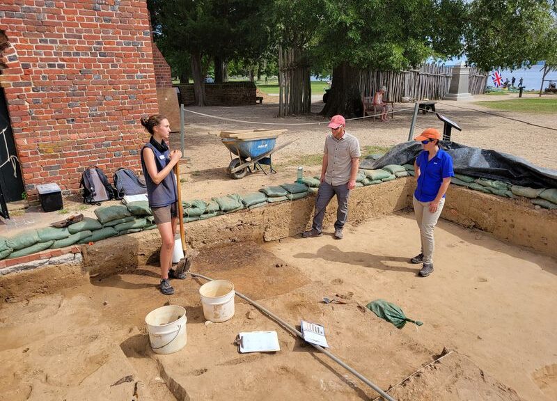
While placing lights at the front of Historic Jamestowne’s memorial church ahead of its 2019 reopening, Jamestown Rediscovery’s Senior Staff Archaeologist Sean Romo made an interesting discovery: burn deposits buried just below the surface.
The artefacts, including window leads, collected on top of the burn deposits, date to just after the 1676 fire.
With several recorded accounts of open fires at the settlement, Romo said there were three possible causes. It could be evidence of the January 1608 fort burning, the result of Confederate troops’ 1862 retreat or it could be evidence of Bacon’s Rebellion in 1676.
But the team could not definitively decide until they opened up the ground. But Romo had his doubts. While Confederate forces occupied the site, several spots around the island were disturbed in order to fortify the wall.
But, what the team uncovered was something of wonder: a square, 15-by-15 feet, filled with intact burn deposits along with several artefacts on the surface.
“We expected this space to be disturbed in some way, but once we took off the modern deposits, we were shocked. The fact that this site is really intact is incredible,” Romo said.
While historians have well-documented accounts of Nathaniel Bacon’s 1676 siege of Jamestown, there had never been any evidence identified as the burning of the island’s parish church.
But, nearly 345 years after the recorded event, the Jamestown Rediscovery’s team has definitively confirmed evidence of “one of the most unusual and complicated chapters in Jamestown’s history,” according to the National Park Service’s article.
While the team had several causes to consider, Romo said the artefacts, including window leads, collected on top of the burn deposits, date to just after the 1676 fire, proving that what they were looking at were from a wooden structure predating the rebellion.
On Sept. 19, 1676, Nathaniel Bacon led a siege on Jamestown, burning the site to the ground after several skirmishes with Gov. Sir William Berkeley over Native relations.
The rebellion is known as the first of its kind in the American colonies as Bacon, a wealthy landowner, gained the support of poor farmers.
Additionally, in a second dig site along the church’s eastern wall, there is definitive evidence of the construction of the existing brick church tower following its burning.
According to Director of Archaeology Dave Givens, this discovery is crucial in telling the complete story of Jamestown’s history and the team plans to continue their efforts to understand other artefacts at the site.
“We have positive evidence of Bacon’s Rebellion and the burning that took place,” Givens said. “The nice thing about this dig is that, as it evolves, it will help us understand more about the layers and what we’re seeing every day.”
“Truly Heartbreaking”: Osage Nation Decries Sale of Cave Containing Native American Art
An anonymous bidder has purchased Picture Cave, a Missouri cave system filled with 1,000-year-old Native American artwork, for $2.2 million. Held by St. Louis–based Selkirk Auctioneers & Appraisers, the sale went forward despite the Osage Nation’s efforts to block it, reports Jim Salter for the Associated Press (AP).
The Missouri cave featuring artwork from the Osage Nation dating back more than 1,000 years.
In a statement quoted by the AP, the Osage Nation—which had hoped to “protect and preserve” the site—described the auction as “truly heartbreaking.”
“Our ancestors lived in this area for 1,300 years,” the statement reads. “This was our land. We have hundreds of thousands of our ancestors buried throughout Missouri and Illinois, including Picture Cave.”
Selkirk’s website describes the two-cave system, located about 60 miles west of St. Louis, as the “most important rock art site in North America.” Between 800 and 1100 C.E., the auction house adds, people, used the caves for sacred rituals, astronomical studies and the transmission of oral tradition.
“It was a collective commune of a very significant space and there is only speculation on the number of Indigenous peoples that used the space for many, many, many different reasons, mostly communication,” Selkirk Executive Director Bryan Laughlin tells Fox 2 Now’s Monica Ryan.
Husband-and-wife scholarly team Carol Diaz-Granados and James Duncan, who have spent 20 years researching the cave, opposed the sale. Diaz-Granados is an anthropologist at Washington University in St. Louis, while Duncan is the former director of the Missouri State Museum and a scholar of Osage oral history.
“Auctioning off a sacred American Indian site truly sends the wrong message,” Diaz-Granados tells the AP. “It’s like auctioning off the Sistine Chapel.”
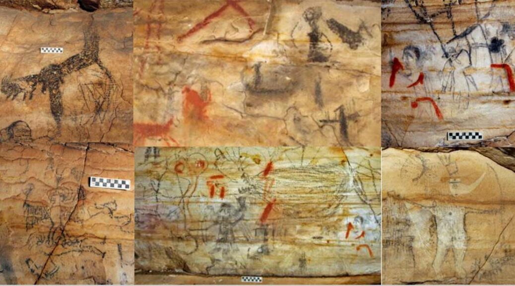
The art appears to depict supernatural beings, including a figure known as Birdman or Morning Star.
Some of the Picture Cave rock art is almost childish, as if it was sketched out by a child yesterday, has uncorrected C-14 date of AD 1000 +/- 100, Diaz-Granados et al. 2015.
An ancient almost black and white rock art example at Picture Cave, Missouri.
The scholar adds that the cave’s art, made largely with charred botanical materials, is more intricate than many other examples of ancient artwork.
“[Y]ou get actual clothing details, headdress details, feathers, weapons,” she says. “It’s truly amazing.”
Diaz-Granados tells St. Louis Public Radio’s Sarah Fenske that state archaeologists who first visited the cave decades ago thought the pictures were modern graffiti because of their high level of detail. But a chemical analysis showed that they dated back about 1,000 years. Duncan adds that the drawings hold clear cultural significance.
“The artists who put them on the wall did it with a great deal of ritual, and I’m sure there were prayers, singing—and these images are alive,” he says. “And the interesting thing about them as far as artists are concerned is the tremendous amount of detail and the quality of portraiture of the faces. Most of them are people—humans—but they’re not of this world; they’re supernatural.”
The artwork may represent an early achievement of the Mississippian culture, which spread across much of what’s now the southeastern and midwestern United States between about 800 and 1600 C.E., writes Kaitlyn Alanis for the Kansas City Star.
During this period, people in the region increasingly based their economies on the cultivation of corn and other crops, leading to the creation of large towns typically surrounded by smaller villages.
Per Encyclopedia Britannica, Mississippian people adopted town plans centred on a plaza containing a temple and pyramidal or oval earth mounds. These designs were similar to patterns adopted more than 1,000 years prior in parts of Mexico and Guatemala.
Among the most prominent surviving Mississippian sites are the Cahokia Mounds earthworks, which are situated just outside of St. Louis in Illinois. The city flourished from 950 to 1350 C.E. and was home to as many as 20,000 residents at its height. In 2008, Duncan told the Columbia Missourian’s Michael Gibney that the Picture Cave artists probably had ties to Cahokia. He argued that some of the drawings depict supernatural figures, including the hero known as Birdman or Morning Star, who was known to have been important in Mississippian culture.
The cave system and 43 acres of surrounding land were sold by a St. Louis family that had owned them since 1953. The sellers mainly used the land for hunting. In addition to its cultural significance, the cave system is home to endangered Indiana bats.
Laughlin tells the AP that the auction house vetted potential buyers. He believes the new owner will continue to protect the site, pointing out that, as a human burial site, the location is protected under state law. It’s also fairly inaccessible to would-be intruders.
“You can’t take a vehicle and just drive up to the cave,” Laughlin says. “You have to actually trek through the woods to higher ground.” Only then can visitors squeeze through the 3- by 3-foot cave opening.
Ancient Artifacts Discovered in Stomach of Huge Mississippi Alligator
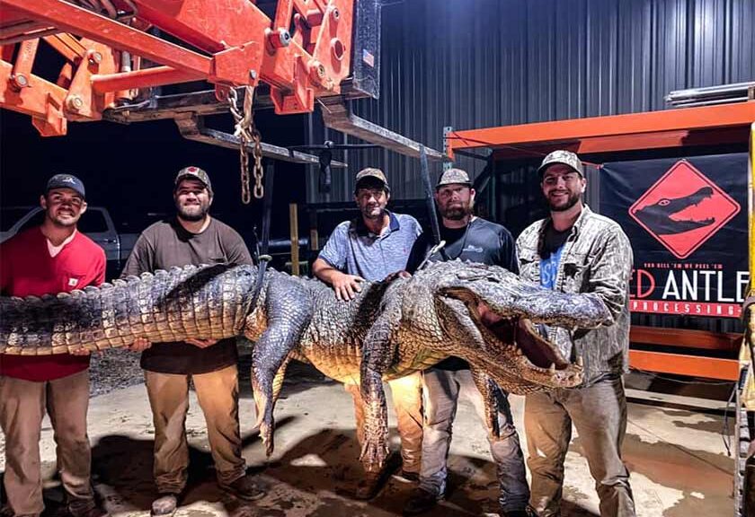
What does a 750-pound alligator eat? Well, just about anything it wants, but items found in this particular Mississippi alligator’s stomach defy odds and date back thousands of years. Shane Smith, the owner of Red Antler Processing in Yazoo City, said he was examining the contents of a 13-foot, 5-inch alligator that weighed 750 pounds and discovered two unusual objects. One he couldn’t identify, but the other was clearly a broken stone arrowhead.
The find was so unexpected, he almost didn’t let the news out.
“At first, I thought ‘I’m not posting this on Facebook,’ because no one will believe it,” Smith said.
It was inside of this giant Mississippi alligator, which was 13.4 feet (4.1 meters) long and weighed 750 pounds (340 kg), that the two ancient artefacts were found.
Then, he had second thoughts.
“This is too cool not to post on Facebook,” he said. “This has probably never happened before. We gotta post this.”
Dog tags in an alligator’s stomach
The story first began to unfold in April when a wild game processor in South Carolina reported opening the stomach of an alligator and finding unusual items. Smith read it and was sceptical.
“The curiosity struck me when I saw a post online about someone finding dog tags in an alligator’s stomach,” Smith said. “I’m one that doesn’t believe in fake news.”
To satisfy that curiosity, Smith decided to examine the contents of the larger alligators he processed. The first was a 13-foot, 2-inch, 787-pound gator taken by Ty Powell of Columbia.
“We found a bullet in it and it had not been fired from a gun,” Smith said. “I don’t know how it got in there.”
The second alligator he opened, which was harvested at Eagle Lake, contained many of the things the first did, including bones, hair, feathers and stones. Then, something else caught his eye.
The two artefacts found in the Mississippi alligator’s stomach: the 6,000-BC atlatl dart point (top), and the black plummet stone from 1,700 BC (bottom).
A find like no other
“Everybody was standing around like I was opening a Christmas present,” Smith said. “We kind of put it all in a bin.
“I looked over and saw a rock with a different tint to it. It was the arrowhead.”
Smith said he was dumbfounded.
“It was just disbelief,” Smith said. “There’s just no way he had an arrowhead. Your first thought is it ate (a Native American) or (a Native American) shot it in the stomach.”
Smith knew that wasn’t the case, though.
“My best hypothesis is wherever he scooped up those other rocks, he got that Indian point,” Smith said. “We joked about it and said I’m probably the only person on Earth to pull an arrowhead out of an alligator’s stomach.”
Point dates back thousands of years
Photographs and radiographs of atlatl dart foreshafts and points.
James Starnes, Director of Surface Geology and Surface Mapping for the Mississippi Department of Environmental Quality examined a photograph of the point. He estimated it was made about 5000-6000 BC. That is the latter part of the Early Archaic and early part of the Middle Archaic (periods),” Starnes said. “How the base is made is real tell-tale in estimating the time period.” Starnes also noted the object is not an arrowhead. It’s a point used on an early weapon that launches a spear using a second piece of wood with a cup on one end which acts as a lever to increase velocity.
“That’s an atlatl dart point,” Starnes said. “People think all heads are arrowheads, but those (arrowheads) would be the little bitty points.”
As bizarre as the find was, it was about to get even stranger. Smith found a heavy, tear-shaped object roughly 1½ inches in length. Both he and the hunter who was permitted to harvested the alligator, John Hamilton of Raleigh, though it was something more modern — a lead weight used for fishing.
“It’s heavy as lead,” Hamilton said. “It looks like it’s got two holes in it, but they don’t go through it.
“It’s got a little hole and a bigger hole on top. I guess it goes in and comes back out.” Hamilton researched the object online but wasn’t successful in identifying it.
“I haven’t found anything the shape of it in fishing stuff,” Hamilton said.
What’s a plummet, and why would an alligator eat it?
Starnes said it’s known as a plummet and dates back to the Late Archaic Period, or about 1700 BC. The weight is accounted for because it’s made of hematite, an iron oxide traded between early groups and shines when polished. Starnes said what the purpose plummets served is unknown.
“The plummets, we really have no idea what they were used for,” Starnes said. “These things had some significance, but we have no idea. We can only guess.”
So, how did these ancient objects get into the alligator’s belly? Ricky Flynt, Mississippi Department of Wildlife, Fisheries, and Parks Alligator Program coordinator, explained very hard objects, typically stones, aid the reptiles indigestion.
“Alligators, like other animals such as birds and other reptiles, are known for ingesting grit and rocks to help with digestion,” Flynt said. “We know alligators and crocodiles do that.”
However, alligators differ from fowl such as chickens and ducks. Those animals have gizzards and the grit and sand are stored there to help grind seeds and grains they consume. Alligators don’t have gizzards and the stones go into the stomach.
“Sticks, wood; things they can’t digest get into their stomachs,” Flynt said. “I found a piece of cypress in an alligator’s stomach that was 15 inches long.”
Possible Prehistoric Campsite Uncovered in Northern Wyoming
Artefacts found this summer at Medicine Lodge Archaeological Site are slated for radiocarbon dating, which could tell researchers more about when the Crow, or Apsáalooke, people came to the area, according to the Wyoming State Archaeologist.
“This summer, we found Crow ceramics, as well a range of things, from thousands and thousands of flakes and 10 arrow points (or arrowheads), and preforms to make arrowheads, to animal bone from bison as well as bighorn sheep, as well as obsidian,” Wyoming State Archaeologist Spencer Pelton said.
“We really hoped to find Crow ceramics to radiocarbon date, to have a better idea of how old those ceramics are,” he said.
Sharon Peregoy, a member of the Montana House of Representatives who represents the Crow Agency, said that this type of work may help date, early people of the area, preserving — or recovering — a history that can otherwise be lost.
“It helps dispel the concept that the Crow, Apsáalooke, people were new transplants to the area,” she said, adding that in this context, “new” means the arrival of 500 years ago.
“The findings of these types of excavations and research correlates with our Crow oral history, which dates from time immemorial. … Prehistoric,” Peregoy said. “History is important to preserve a homeland for future generations.”
The Office of the Wyoming State Archaeologist is currently doing a ceramics research project, and had hoped to find similar material at Medicine Lodge during its first-ever “public excavation” this summer, Pelton said. The area that is now Medicine Lodge State Archaeological Site has been continuously occupied for more than 10,000 years, according to Wyoming State Parks. In the 1880s it was a working cattle ranch. In 1972, it was purchased by the Wyoming Game and Fish Department, which created the 12,000-acre Medicine Lodge Wildlife Habitat Management Area.
In 1973, a portion of the habitat management area was developed into Medicine Lodge State Archaeological Site. Today, visitors can camp along Medicine Lodge Creek, which flows through a canyon that offers respite in the summer from the hot, dry desert, and warmth and shelter in the winter.
“This spot was undoubtedly a campsite for a long time,” Pelton said. “It’s such an oasis down there, with fresh water. It probably stays fairly warm in the winter from the heat radiating off of the cliffs, and then relatively cool in the summer.
“I know it stays relatively cool in the summer because the moment you climb out of that canyon the temperature increases by 15 degrees,” he said of his experience at the excavation this summer. Because Medicine Lodge is a high-traffic area, and one accessible to the public, it was the ideal place to engage the public with the research.
“We encouraged people to stop by and take a look at what we were doing, maybe screen some dirt,” he said, adding that around 600 people stopped over the summer.
“It turned out really great, and in the process we got some legitimate research done as well,” Pelton said.
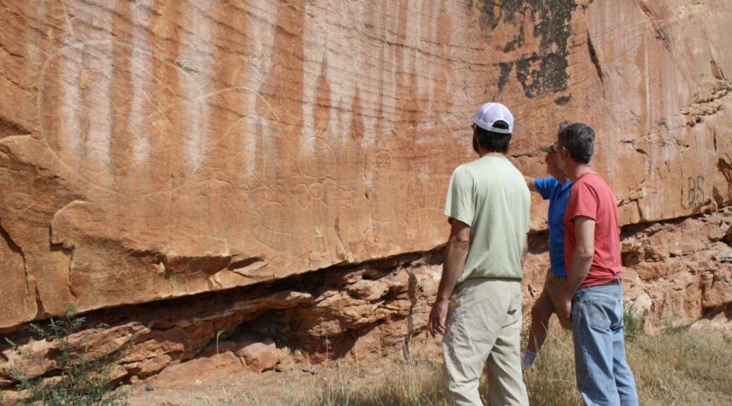
The rock art in the valley dates back 10,000 years, and includes petroglyphs and painted rock-art images, or pictographs. The rock art covers the face of a 750-foot-long sandstone bluff, which shelters the area at its base from the wind.
Medicine Lodge State Archaeological Site is home to Native American petroglyphs and pictographs dating back more than 10,000 years.
“The rock art certainly includes Crow art,” Pelton said. “When you look at modern Crow art, and look at Crow mythology, you can see a lot of the same motifs on the rock art and cliffs from around A.D. 1400, 1600. A lot of those traditions are still around today.”
Other rock art at Medicine Lodge likely predates the Crow people, he said.
“That is the amazing thing about Medicine Lodge. People probably came and made rock art there for thousands and thousands of years, and we still see the last couple thousand years of it today,” Pelton said. “People were making images on top of each other over and over again.”
Previous excavations done in the 1970s revealed an early presence in the valley.
“It was thought to be an archaeological site created by the ancestors of the Crow,” Pelton said. “(Early researchers) knew that from portions of a ceramic vessel they found there, the rim of a pot.”
Finding ceramics like that is rare in Wyoming, but also valuable as one of the best artefacts for determining ancestry.
“These things are really distinct, and you can track them across time and space to see how those different finds change through time,” Pelton explained. “Our first research priority is getting some radiocarbon dates on some charcoal, and maybe animal bone, with some of those ceramics.”
Another thing found this summer during the public excavation was obsidian, which almost certainly came from the Crow component at Medicine Lodge.
“Obsidian is distinct from all the preceding 12,000 years of prehistory at Medicine Lodge Creek,” he said. “The great thing about obsidian is that you can source it precisely to specific outcrops, so we will know now where these people carrying Crow-style pottery into Medicine Lodge Creek came from. It is probably somewhere in Yellowstone, it could be Teton Pass or it could be all the way over in Idaho.”
Pelton said his office will likely do another public excavation in the summer of 2022. The key is finding a site that is accessible to the public and safe for people to gather.
“The tricky part is finding that perfect confluence of places that are publicly accessible that also have a cool archaeological site buried underneath it,” Pelton said, adding that the tentative plan is to do a similar event at Edness Kimball Wilkins Park in Natrona County. He hopes to reach people there who may not otherwise know about Wyoming’s archaeological past.
“There are some really well-known, easily accessible archaeological sites in that park, and that place gets a lot of visitation,” Pelton said. “We can start reaching a whole other demographic of people who are not normally exposed to this kind of thing, and expand our education and outreach opportunities.”
New evidence supports idea that America’s first civilization was made up of ‘sophisticated’ engineers
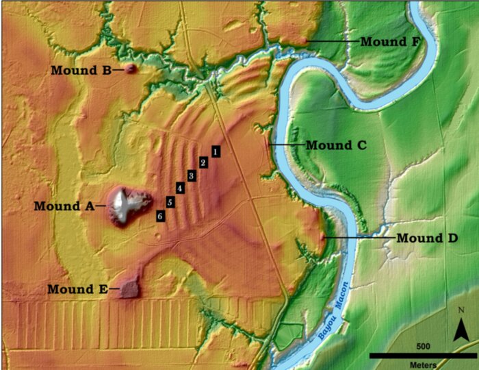
The illustration above shows the core features of the Poverty Point site in northern Louisiana. The green to the right is the Mississippi River flood plain. The orange is Macon Ridge, the higher ground on which the site is located. Six C-shaped ridges are visible at the site. Parts of the ridges have been damaged by historic and modern activities. The pattern south of Mound E is the result of farm activity. Many of the low areas around the site – lighter yellow – are thought to be places where the soil was mined to make ridges and mounds.1 of 3The illustration above shows the core features of the Poverty Point site in northern Louisiana. The green to the right is the Mississippi River flood plain. The orange is Macon Ridge, the higher ground on which the site is located. Six C-shaped ridges are visible at the site. Parts of the ridges have been damaged by historic and modern activities. The pattern south of Mound E is the result of farm activity. Many of the low areas around the site – lighter yellow – are thought to be places where the soil was mined to make ridges and mounds.
The Native Americans who occupied the area known as Poverty Point in northern Louisiana more than 3,000 years ago long have been believed to be simple hunters and gatherers. But new Washington University in St. Louis archaeological findings paint a drastically different picture of America’s first civilization.
Far from the simplicity of life sometimes portrayed in anthropology books, these early Indigenous people were highly skilled engineers capable of building massive earthen structures in a matter of months — possibly even weeks — that withstood the test of times, the findings show.
“We as a research community — and population as a whole — have undervalued native people and their ability to do this work and to do it quickly in the ways they did,” said Tristram R. “T.R.” Kidder, lead author and the Edward S. and Tedi Macias Professor of Anthropology in Arts & Sciences.
“One of the most remarkable things is that these earthworks have held together for more than 3,000 years with no failure or major erosion.
By comparison, modern bridges, highways and dams fail with amazing regularity because building things out of the dirt is more complicated than you would think. They really were incredible engineers with very sophisticated technical knowledge.”
The findings were published in Southeastern Archaeology on September 1, 2021. Washington University’s Kai Su, Seth B. Grooms, along with graduates Edward R. Henry (Colorado State) and Kelly Ervin (USDA Natural Resources Conservation Service) also contributed to the paper.
The Poverty Point World Heritage site consists of a massive 72-foot-tall earthen mound and concentric half-circle ridges. The structures were constructed by hunter-gatherers approximately 3,400 years ago from nearly 2 million cubic yards of soil.
Amazingly, this was done without the luxury of modern tools, domesticated animals or even wheeled carts.
An excavation before sampling. Note the colour changes between layers. The darker layers have carbon-rich deposits made by humans, such as midden or garbage that was scraped up and dumped to form the ridge structure during construction. There is little organic garbage in the upper third section.
According to Kidder, the site was likely an important religious site where Native Americans came in pilgrimage, similar to Mecca. It was abandoned abruptly between 3,000-3,200 years ago — most likely due to documented flooding in the Mississippi Valley and climate change.
The ridges at Poverty Point contain vast amounts of artefacts around the edges and within, suggesting that people lived there. Kidder and the team re-excavated and re-evaluated a site on Ridge West 3 at the Poverty Point Site that was originally excavated by renowned archaeologist Jon Gibson in 1991.
Using modern research methods including radiocarbon dating, microscopic analysis of soils and magnetic measurements of soils, the research provides conclusive evidence that the earthworks were built rapidly. Essentially, there is no evidence of boundaries or signs of weathering between the various levels, which would have occurred if there was even a brief pause in construction. Kidder believes the construction was completed in lifts, or layers of sediment deposited to increase the ridge height and linear dimensions before another layer were placed to expand the footprint vertically and horizontally.
Why does that matter? According to Kidder, the findings challenge previous beliefs about how pre-modern hunters and gatherers behaved. Building the enormous mounds and ridges at Poverty Point would have required a large labour pool that was well organized and would have required leadership to execute. Hunters and gathers were believed to shun politics.
“Between the speed of the excavation and construction, and the quantity of earth being moved, these data show us native people coming to the site and working in concert. This in and of itself is remarkable because hunter-gatherers aren’t supposed to be able to do these activities,” Kidder said.
What’s even more impressive than how quickly the people built the earthen structures is the fact that they’re still intact. Due to its proximity to the Gulf of Mexico, this area receives immense amounts of rain that makes earthworks especially prone to erosion. Microscopic analysis of soils shows that the Native Americans mixed different types of soil — clays, silts and sand — in a calculated recipe to make the structures stronger.
“Similar to the Roman concrete or rammed earth in China, Native Americans discovered sophisticated ways of mixing different types of materials to make them virtually indestructible, despite not being compacted. There’s some magic there that our modern engineers have not been able to figure out yet,” Kidder said.
Ancient humans could do some impressive things with elephant bones
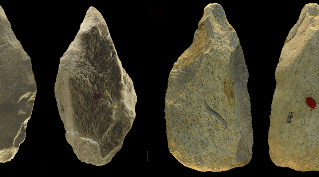
Bone tools were excavated from Castel di Guido in Italy.
In a new study, University of Colorado Boulder archaeologist Paola Villa and her colleagues surveyed tools excavated from a site in Italy where large numbers of elephants had died. The team discovered that humans at this site roughly 400,000 years ago appropriated those carcasses to produce an unprecedented array of bone tools—some crafted with sophisticated methods that wouldn’t become common for another 100,000 years.
“We see other sites with bone tools at this time,” said Villa, an adjoint curator at the CU Boulder Museum of Natural History. “But there isn’t this variety of well-defined shapes.”
Top: Elephant tusks and other bones at the Castel di Guido site during excavation; middle: A series of pointed elephant bone tools from Castel di Guido; bottom: A lissoir, or smoother, a tool made from a wild cattle bone.
Villa and her colleagues published their results this month in the journal PLOS ONE.
The study zeroes in on a site called Castel di Guido not far from modern-day Rome. Hundreds of thousands of years ago, it was the location of a gully that had been carved by an ephemeral stream—an environment where 13-foot-tall creatures called straight-tusked elephants (Palaeoloxodon antiquus) quenched their thirst and, occasionally, died.
Castel di Guido’s hominids made good use of the remains, occupying the site off and on over the years. The researchers report that these Stone Age residents produced tools using a systematic, standardized approach, a bit like a single individual working on a primitive assembly line.
“At Castel di Guido, humans were breaking the long bones of the elephants in a standardized manner and producing standardized blanks to make bone tools,” Villa said. “This kind of aptitude didn’t become common until much later.”
Stone Age toolbox
These feats of ingenuity came at a significant time for hominids in general.
Right around 400,000 years ago, Neanderthals (Homo neanderthalensis) were just beginning to emerge in Europe. Villa suspects that Castel di Guido’s residents were Neanderthals.
“About 400,000 years ago, you start to see the habitual use of fire, and it’s the beginning of the Neanderthal lineage,” Villa said. “This is a very important period for Castel di Guido.”
It may have been a productive one, too. In their new study, Villa and her colleagues identified 98 bone tools from Castel di Guido, which was excavated from 1979 to 1991. The findings represent the highest number of flaked bone tools made by pre-modern hominids that researchers have described so far. That rich toolbox offered a wide range of useful items: Some tools were pointed and could, theoretically, have been used to cut meat. Others were wedges that may have been helpful for splitting heavy elephant femurs and other long bones.
“First you make a groove where you can insert these heavy pieces that have a cutting edge,” Villa said. “Then you hammer it, and at some point, the bone will break.”
But one tool stood out from the rest: The team discovered a single artifact carved from a wild cattle bone that was long and smooth at one end. It resembles what archaeologists call a “lissoir,” or a smoother, a type of tool that hominids used to treat leather. The curious thing: Lissoir tools didn’t become common until about 300,000 years ago.
“At other sites 400,000 years ago, people were just using whatever bone fragments they had available,” Villa said.
Useful finds
Something special, in other words, seemed to be happening at the Italian site.
Villa doesn’t think that the Castel di Guido hominids were any more intelligent than their counterparts elsewhere in Europe. Instead, these early humans simply used the resources they had lying around. She explained that this region of Italy doesn’t have a lot of naturally occurring, large pieces of flint, so ancient humans couldn’t make many large stone tools.
What the region might have had a lot of, however, were dead elephants. As the Stone Age progressed, straight-tusked elephants slowly disappeared from Europe. During the era of Castel di Guido’s bone-crafters, these animals may have flocked to watering holes at the site, occasionally dying from natural causes. Humans then found the remains and butchered them for their long bones.
“The Castel di Guido people had cognitive intellects that allowed them to produce complex bone technology,” Villa said. “At other assemblages, there were enough bones for people to make a few pieces, but not enough to begin a standardized and systematic production of bone tools.”
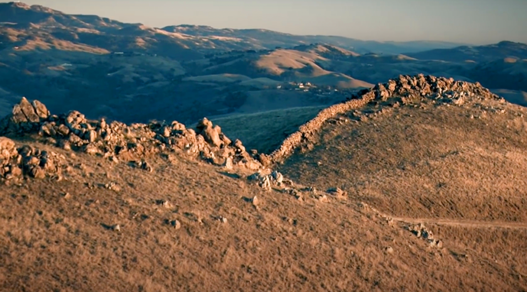
Mystery of the “East Bay” rock walls in California?
There are Remnants of Ancient stone walls all over the East Bay, and no one knows how old they are, who built them, or why?
Though people have been pondering the enigma of the Berkeley Mystery Walls for well over a hundred years, no conclusions have been reached, and despite wild speculation, no serious scholarly study has ever been undertaken.
Stretching for over 50 miles, the East Bay “Mystery Walls” are found up and down the hills of the East Bay from Berkeley to San Jose.
The stone walls are up to five feet tall in places and are constructed from boulders of varying sizes, some weighing up to a ton.
The walls run in broken sections, anywhere from a few meters to half a mile in length, and are placed in unlikely and inaccessible places. They seem to serve no known purpose.
They are not continuous or high enough to act as an enclosure, or measure of defence. They are clearly, visibly, very old.
The heavy stones have sunk deep into the ground, and they are overgrown with lichen. After meandering throughout the Oakland hills, they head inland towards Mt. Diablo where they lead to mysterious stone circles, up to 30 feet in diameter. In one place the walls form a spiral 200 feet wide that circles a large boulder.
The Spanish settlers in the area reported that the walls were already there when they arrived, and when they asked the local Ohlone American Indians, they said the same thing.
In 1904, the founder of the Contra Costa Club said the walls were clearly of prehistoric origin and could be evidence that an advanced civilization had once settled in the East Bay.
Also in 1904, the professor of Oriental languages at UC Berkeley declared that the walls were surely the work of settlers from Mongolia, as the Chinese tended to wall in their cities, and the mystery walls were reminiscent of the Great Wall of China.
Others have theorized that they were built by the early Missionaries, and still, others wonder if Sir Frances Drake did not leave colonists behind at the site where he completed the circumnavigation of the globe.
While speculations abound, the “Mystery Walls of the East Bay,” or the “Great Wall of California” remains a mystery to this day.
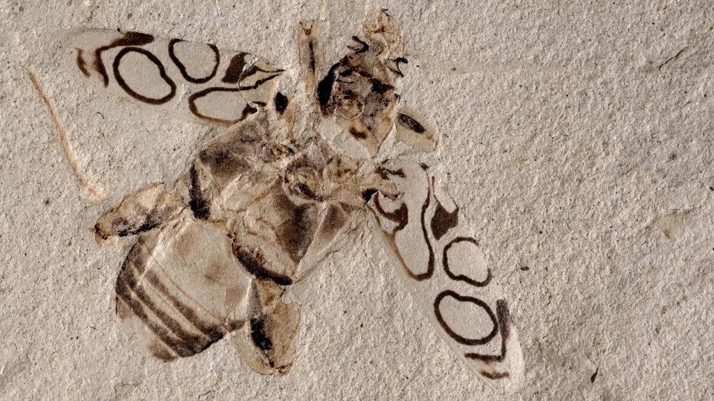
The insect, which is 49 million years old, appears to have been smashed just a few days ago
A beetle that lived about 49 million years ago is so well-preserved that the insect looks like it could spread its strikingly patterned wing coverings and fly away. That is if it weren’t squashed and fossilized.
Though originally identified as a type of long-horned beetle, Pulchritudo attenboroughi belongs to the frog-legged beetle group.
Wing cases, or elytra, are one of the sturdiest parts of a beetle’s exoskeleton, but even so, this level of colour contrast and clarity in a fossil is exceptionally rare, scientists recently reported.
The beautiful design on the ancient beetle’s elytra prompted researchers to name it Pulchritudo attenboroughi, or Attenborough’s Beauty, after famed naturalist and television host Sir David Attenborough. They wrote in a new study that the pattern is “the most perfectly preserved pigment-based colouration known in fossil beetles.”
When the researchers described the beetle beauty, it was already in the collection of the Denver Museum of Nature and Science (DMNS) in Colorado, where it had been on display since it was identified in 1995.
Palaeontologists found the fossil that year in the Green River Formation; once a group of lakes, this rich fossil site spans Colorado, Wyoming and Utah, and dates to the Eocene epoch (55.8 million to 33.9 million years ago).
Scientists initially classified the fossil as a long-horned beetle in the Cerambycidae genus. But while its body shape resembled those of long-horned beetles, its hind limbs were unusually short and beefy, which led the museum’s senior curator of entomology — Frank-Thorsten Krell, lead author of the new study — to question if the beetle might belong to a different group.
In the study, the authors described the beetle as a new genus in a subfamily known for its robust and powerful hind legs: frog-legged leaf beetles.
The fossilized insect, a female, is only the second example of a frog-legged leaf beetle to be found in North America, Krell told Live Science in an email (no modern beetles in this group live in North America today, according to the study).
On P. attenboroughi’s back, dark and symmetrical circular patterns stand out in sharp contrast against a light background. This suggests that bold patterns were present in beetles at least 50 million years ago, the researchers reported.
Digital reconstruction of Pulchritudo attenboroughi.
For a beetle to fossilize as well as this one did, “you need a very fine-grained sediment,” Krell said. Silt or clay at the bottom of a lake is the best substrate for fossilizing insects, and the beetle must sink quickly into the silty lake bottom before its body disintegrates. “And then it should not rot, so an oxygen-poor environment on the lake floor is helpful,” he said.
However, questions still remain about how sediments in the lake bottom preserved the beetle’s high-contrast colours so vividly, Krell added.
Visitors to the DMNS can admire P. attenboroughi for themselves, as the renamed fossil is back on display in the museum’s “Prehistoric Journey” exhibit, representatives said in a statement.