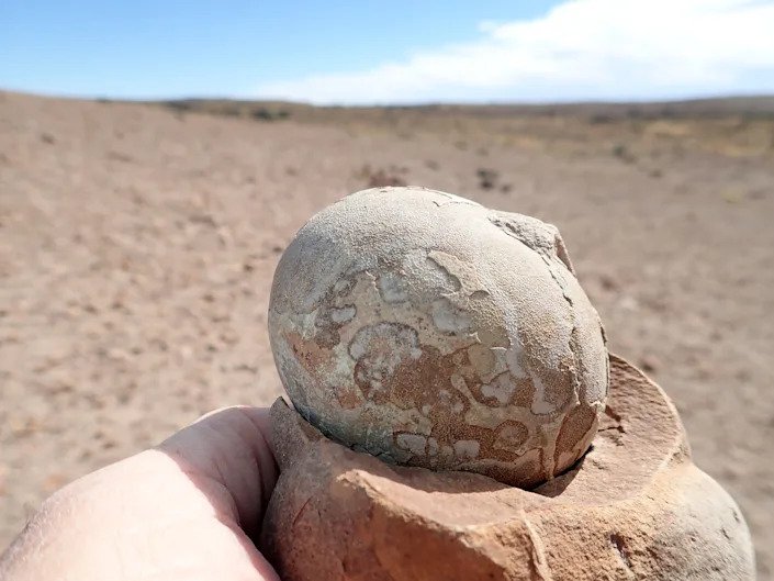
Category Archives: WORLD

Archaeologists Map Nearly 500 Mesoamerican Sites and See Distinct Design Patterns

Archaeologists Map Nearly 500 Mesoamerican Sites and See Distinct Design Patterns

Gizmodo reports that lidar technology was used to create 3-D maps of some 30,000 square miles of Mexico, revealing more than 475 archaeological sites dating from 1400 B.C. to A.D. 1000.

A lidar image of the sites of San Lorenzo (left) and Aguada Fénix (right) show striking similarities, with a long rectangular platform and 20 edge platforms.

The 478 sites included in the new research were inhabited from around 1400 BCE to 1000 CE, and the way they were constructed appears to be linked to cosmologies important to the communities that lived there.

Settlements that align with nearby mountain peaks or the Sun’s arc across the sky suggest there may have been symbolic importance to the orientation of the architecture.

The team categorized the sites into five distinct types of architectural arrangements, which they think might correspond to different time periods and indicate more egalitarian societies.

All the sites had rectangular or square features, which the archaeologists say may have been inspired by the famous Olmec site of San Lorenzo, which had a central rectangular space that was likely used as a public plaza. The team’s survey and analysis were published today in Nature Human Behavior.

“The main point of this study is the discovery of nearly 500 standardized complexes across a broad area, many of them having rectangular shapes,” wrote lead author Takeshi Inomata, an archaeologist at the University of Arizona, in an email to Gizmodo. “Until three years ago, we had no idea about the presence of such complexes. They really force us to rethink what was happening during this period.

The team used an aerial scanning technology called lidar to map hidden structures at these sites. With lidar, archaeologists can get precision measurements of ground elevation change, even through dense tree coverage, thanks to lasers that penetrate the surface and then bounce back to a detector.

Lidar is “revolutionary for archaeology,” Robert Rosensweig, an archaeologist at the University of Albany-SUNY who didn’t work on the recent paper, wrote in an accompanying News & Views article for Nature

“The study foreshadows the future for archaeology as lidar reveals ancient architecture at an unprecedented scale that will reach into remote and heavily vegetated regions the world over,” Rosensweig added.

In 2020, Inomata and his colleagues reported their discovery of the monumental site of Aguada Fénix using lidar imaging. Now, they’ve looked at 2,000 years of architecture in the region through aerial lidar surveys.

A lidar-based illustration of the site Buenavista, which appears to be aligned with the sunrise on certain days of the year.

The people who designed these settlements are broadly called the Olmec and Maya, though there are better, more specific names for communities that fall under those labels, such as the Chontal-speaking residents of eastern Tabasco and the Zoke-speaking people of western Tabasco and Veracruz.

The Olmec site maps are particularly handy; the centre of San Lorenzo is the oldest capital in the area (it’s the home of those colossal heads you might be familiar with), and as such, archaeologists believe it may have set the standard for how to layout a settlement.

But San Lorenzo was well known already; part of the value of this new research is highlighting the structures of smaller settlements. “Although this part of Mexico is fairly open and populated, most of those sites were not known before,” Inomata added. “They were literally hiding in plain sight.”

Together, the nearly 500 sites give archaeologists a sense of how communities in the area are organized. Inomata said the research impacts are two-fold: One, archaeologists now have a better idea as to the development of monumental building projects in the region over time. Two, based on the site layouts, it appears that communities didn’t have a highly stratified social hierarchy.

READ ALSO: LIDAR REVEALS NETWORK OF ANCIENT VILLAGES IN BRAZIL’S RAINFOREST

“Traditionally, archaeologists thought large constructions were done by hierarchical societies with elites and rulers,” Inomata said. “But we now see that those large and standardized spaces could be built by people without pronounced inequality.” That determination is in part based on the lack of large permanent residences at many of the sites.

The archaeological team’s next steps are to visit the sites in person, to verify that the patterns represented from the air are the reality on the ground. That’s an extremely important step, as evidenced by a situation in 2016 in which a teenager thought he found a lost city in satellite imagery, only for archaeologists to disagree, saying it was probably a fallow maize field.

So far, only about 20% of the sites the team surveyed have been studied on the ground. While those ground survey results are promising, more data needs to be collected for researchers to know the extent of architectural similarities and differences in the region.

Archaeologists in Iraq find ancient wine press, carvings

Archaeologists in Iraq find ancient wine press, carvings

According to an AFP report, researchers working at the site of Khinis in northern Iraq uncovered stone-cut pits dated to the eighth century B.C. and the reign of the Assyrian king Sennacherib.

Archaeologists in Iraq find ancient wine press, carvings
The carvings, from 2,700 years ago, show gods, kings and sacred animals.

The stone bas-reliefs, showing kings praying to the gods, were cut into the walls of a nearly nine-kilometre-long (5.5-mile) irrigation canal at Faida in northern Iraq, the joint team of archaeologists from the Department of Antiquities in Dohuk and colleagues from Italy said.

The carvings, 12 panels measuring five metres (16 feet) wide and two metres tall, show gods, kings and sacred animals. They date from the reigns of Sargon II (721-705 BC) and his son Sennacherib.

“There are other places with rock reliefs in Iraq, especially in Kurdistan, but none are so huge and monumental as this one,” said Italian archaeologist Daniele Morandi Bonacossi.

“The scenes represent the Assyrian king praying in front of the Assyrian gods,” he said, noting that the seven key gods are all seen, including Ishtar, the goddess of love and war, who is depicted on top of a lion.

Ancient ‘propaganda scene’

The irrigation canal was cut into limestone to carry water from the hills to the fields of farmers, and the carvings were made to remind people of the king who ordered its construction.

The carvings were made to remind people of the king who ordered the construction of an irrigation canal.

“It was not only a religious scene of prayer, but it was also political, a sort of propaganda scene,” Morandi Bonacossi added.

“The king, in this way, wanted to show to the people living in the area that he was the one who has created these massive irrigation systems, so… the people should remember this and remain loyal.”

At Khinis, also near Dohuk, the team unearthed giant stone basins cut into the white rock that was used in commercial wine-making during the reign of Sennacherib, in the late 8th or early 7th century BC.

“It was a sort of industrial wine factory,” said Morandi Bonacossi, professor of Near Eastern archaeology at the Italy’s University of Udine, adding this was the first such discovery in Iraq.

“We have found 14 installations, that were used to press the grapes and extract the juice, which was then processed into wine.”

Some of the most famous carvings that have survived from the Assyrian period are the mythical winged bulls, with examples of the monumental reliefs seen in the Iraq Museum in Baghdad, as well as the Louvre in Paris and the British Museum in London.

Iraq was the birthplace of some of the world’s earliest cities. As well as Assyrians it was once home to Sumerians and Babylonians, and to among humankind’s first examples of writing.

Archaeologists in Iraq also discovered stone-cut pits used to press the grapes and extract the juice, which was then processed into wine.

But it is also now a location for smugglers of ancient artefacts. Looters decimated the country’s ancient past, including after the 2003 US-led invasion.

Then, from 2014 and 2017, the Islamic State group demolished dozens of pre-Islamic treasures with bulldozers, pickaxes and explosives. They also used smuggling to finance their operations.

READ ALSO: ISRAEL WINERY: 1,500-YEAR-OLD BYZANTINE WINE COMPLEX FOUND

However, some countries are slowly returning stolen items.

Earlier this year, the United States returned about 17,000 artefacts to Iraq, pieces that mostly dated from the Sumerian period around 4,000 years ago.

Last month, a 3,500-year-old tablet recounting the epic of Gilgamesh was returned to Iraq after being stolen three decades ago and illegally imported to the US.

Wreck of US ship that hunted Nazi spies in the Arctic finally discovered

Wreck of US ship that hunted Nazi spies in the Arctic finally discovered

Live Science reports that the wreckage of the U.S. Revenue Cutter Bear has been found in Canadian waters by the U.S. Coast Guard, the U.S. National Oceanic and Atmospheric Administration (NOAA), and other researcher groups.

Wreck of US ship that hunted Nazi spies in the Arctic finally discovered
The US Revenue Cutter Bear was capable of sailing through Arctic ice.

The Bear has a storied history: It started working as a commercial sealer in 1874. Then, because the ship could travel through ice-filled waters, the government purchased it in the 1880s to use for rescue work in the Arctic. It also served as a relief ship during the Spanish flu pandemic of 1918-1919, a floating museum, a film set for a Hollywood movie and an expedition ship on Adm. Richard Byrd’s Antarctic explorations.

It also patrolled Arctic waters for the U.S. Navy in both world wars, and in 1941 it helped capture the Norwegian trawler Buskø, which was being used by the German military intelligence service Abwehr to report on weather conditions in the North Atlantic.

The Bear was decommissioned in 1944 and tied up at a wharf in Halifax, Nova Scotia. It finally sank after a storm in 1963, somewhere south of Nova Scotia and east of Boston, as it was being towed to Philadelphia.

“The Bear has had such an incredible history, and it’s so important in many ways in American and global maritime heritage because of its travels,” said Brad Barr, the mission coordinator for the U.S. National Oceanic and Atmospheric Administration’s (NOAA) Maritime Heritage Program, who has led the search for the wreck for several years.

A scan of the wreck is believed to be the Bear.

Historic ship

In the late 1970s, a group started searching for the Bear. It included the Massachusetts Institute of Technology’s Harold Edgerton, who invented side-scan sonar — a technology widely used today to detect and image objects on the seafloor.

The group tested out the new side-scan technology in 1979, but they didn’t find the wreck — possibly because the location of its sinking had been misreported by its tow ship, Barr told Live Science..

A secret Navy submersible — the nuclear-powered NR-1 —— carried out a second search in 2007, but it too was unsuccessful. Finally, the U.S. Coast Guard and NOAA joined forces with other partners and began another search in 2019.

After mapping 62 square miles (160 square kilometres) of seafloor with sonar, they identified two submerged objects in the search area. In September, they returned on a Coast Guard ship equipped with a remotely operated vehicle (ROV) to take underwater video and confirm that the largest object is the wreck of Bear, Barr said.

The wreck now lies on the seafloor at a depth of about 200 feet (60 meters), in Canadian waters about 90 nautical miles (167 km) south of Nova Scotia’s Cape Sable. The exact location is being kept confidential in the hopes of deterring technical divers from trying to reach it, Barr said. The search partners are discussing with the Canadian government how the wreck can be protected.

The ageing wooden hull has been badly damaged by nets from fishing trawlers and strong currents on the seafloor. But the researchers identified several distinctive features of the Bear, including the “bow staples” that strengthened its hull to allow the ship to handle heavy ice in polar waters, Barr said. 

An image of the wreck taken by a remotely controlled vehicle.

Steamship to diesel

Although the Bear was equipped with three masts for sailing, it was built as a steamship for its role as a sealer in the 1870s. In the 1930s, the boiler was taken out and the steam engine was replaced with a diesel engine as it was refitted for its Antarctic service with Byrd. 

As a result, several piles of metal can be seen among the remaining wood of the wreck, which includes sailing-ship technologies, Barr said. 

“There’s a pile of metal rubble with a deadeye [a fixed wooden pulley] sticking up out of it,” he said. “These deadeyes have been around since the 1700s, but they were used on the Bear to attach the standing rigging.”

Among the Bear’s most famous exploits was its part in the 1884 rescue fleet for the Greely Expedition to the Arctic, which had become lost in 1881 near Ellesmere Island, northwest of Greenland. Several members of the expedition died of starvation and disease before the Bear rescued Greely and the other survivors. 

After serving for many years as a government revenue cutter in Arctic waters — intercepting and inspecting ships at sea, and often rescuing commercial ships trapped in ice — the Bear was transferred to the Navy; it patrolled around Alaska during World War I, and it delivered supplies there during the Spanish flu pandemic.

In 1929, the decommissioned ship was given to the city of Oakland in California, where it became a floating museum and then a film set for the 1930 movie “The Sea-Wolf,” an adaption of a Jack London novel. 

READ ALSO: ARCHAEOLOGISTS DISCOVER 2200-YEAR-OLD EGYPTIAN SHIPWRECK IN THE MEDITERRANEAN SEA

The Bear was recommissioned for Arctic patrols during World War II, when it helped capture the Buskø; but it was mostly tied up in Halifax after that until it sank in 1963 on its final voyage to Philadelphia, where it was destined to become a floating restaurant.

“These are incredibly compelling stories,” Barr said. “When you read the details of what the Bear did, how many lives it saved, how many incredible missions it was on — it is really the kind of history that people should be aware of.”

To commemorate its discovery, Barr has compiled years of historical research into several website posts detailing the many exploits of the Bear. “One of the reasons why we wanted to find it is because it allows us to tell all these stories,” he said. 

Humans did not cause woolly mammoths to go extinct, climate change did

Humans did not cause woolly mammoths to go extinct, climate change did

According to a statement released by the University of Cambridge, humans did not cause the extinction of the woolly mammoths, even though they are known to have hunted mammoths for food and used the skeletons and hides for shelter, weapons, and artwork.

For five million years, woolly mammoths roamed the earth until they vanished for good nearly 4,000 years ago – and scientists have finally proved why.

The hairy cousins of today’s elephants lived alongside early humans and were a regular staple of their diet – their skeletons were used to build shelters, harpoons were carved from their giant tusks, artwork featuring them is daubed on cave walls, and 30,000 years ago, the oldest known musical instrument, a flute, was made out of a mammoth bone.

A trio of woolly mammoths trudges over snow-covered hills. Behind them, mountains with snow-covered peaks rise above dark green forests of fir trees.

Now the hotly debated question about why mammoths went extinct has been answered – geneticists analysed ancient environmental DNA and proved it was because when the icebergs melted, it became far too wet for the giant animals to survive because of their food source – vegetation – was practically wiped out.

The 10-year research project, published in Nature today (20 October 2021), was led by Professor Eske Willerslev, a Fellow of St John’s College, University of Cambridge, and director of The Lundbeck Foundation GeoGenetics Centre, University of Copenhagen.

The team used DNA shotgun sequencing to analyse environmental plant and animal remains – including urine, faeces and skin cells – taken from soil samples painstakingly collected over a period of 20 years from sites in the Arctic where mammoth remains were found.

The advanced new technology means scientists no longer have to rely on DNA samples from bones or teeth to gather enough genetic material to recreate a profile of ancient DNA. The same technique has been used during the pandemic to test the sewage of human populations to detect, track and analyse Covid-19.

Professor Willerslev said: “Scientists have argued for 100 years about why mammoths went extinct. Humans have been blamed because the animals had survived for millions of years without climate change killing them off before, but when they lived alongside humans they didn’t last long and we were accused of hunting them to death.

“We have finally been able to prove was that it was not just the climate changing that was the problem, but the speed of it that was the final nail in the coffin – they were not able to adapt quickly enough when the landscape dramatically transformed and their food became scarce.

“As the climate warmed up, trees and wetland plants took over and replaced the mammoth’s grassland habitats. And we should remember that there were a lot of animals around that were easier to hunt than a giant woolly mammoth – they could grow to the height of a double-decker bus!”

The woolly mammoth and its ancestors lived on earth for five million years and the huge beasts evolved and weathered several Ice Ages. During this period, herds of mammoths, reindeer and woolly rhinoceroses thrived in the cold and snowy conditions.

Despite the cold, a lot of vegetation grew to keep the various species of animals alive – grass, flowers, plants, and small shrubs would all have been eaten by the vegetarian mammoths who probably their tusks to shovel snow aside and are likely to have used their trunks to uproot tough grasses. They were so big because they needed huge stomachs to digest the grass.

Mammoths could travel a distance equivalent to going around the world twice during their lifetime and fossil records show they lived on all continents except Australia and South America. Populations were known to have initially survived the end of the last Ice Age in small pockets off the coasts of Siberia and Alaska – on Wrangel Island and St Paul Island – but the research found they actually lived longer elsewhere too and the breeds of mammoths on both the islands were closely related despite being geographically separated. As part of the project, the team also sequenced the DNA of 1,500 Arctic plants for the very first time to be able to draw these globally significant conclusions.

Dr Yucheng Wang, first author of the paper and a Research Associate at the Department of Zoology, University of Cambridge, said: “The most recent Ice Age – called the Pleistocene – ended 12,000 years ago when the glaciers began to melt and the roaming range of the herds of mammoths decreased. It was thought that mammoths began to go extinct then but we also found they actually survived beyond the Ice Age all in different regions of the Arctic and into the Holocene – the time that we are currently living in ­– far longer than scientists realised.

“We zoomed into the intricate detail of the environmental DNA and mapped out the population spread of these mammals and show how it becomes smaller and smaller and their genetic diversity gets smaller and smaller too, which made it even harder for them to survive.

“When the climate got wetter and the ice began to melt it led to the formation of lakes, rivers, and marshes. The ecosystem changed and the biomass of the vegetation reduced and would not have been able to sustain the herds of mammoths. We have shown that climate change, specifically precipitation, directly drives the change in the vegetation – humans had no impact on them at all based on our models.”

READ ALSO: OLDEST CIRCULAR STRUCTURE DISCOVERED – AND IT’S MADE OF MAMMOTH BONES

Humans lived alongside woolly mammoths for at least 2,000 years – they were even around when the pyramids were being built. Their disappearance is the last big naturally occurring extinction story. Our fascination with the huge beasts continues today with ‘Manny’ the woolly mammoth starring as the main character in five Ice Age animated films, and scientists hoping to resurrect them from the dead.

Professor Willerslev said: “This is a stark lesson from history and shows how unpredictable climate change is – once something is lost, there is no going back. Precipitation was the cause of the extinction of woolly mammoths through the changes to plants. The change happened so quickly that they could not adapt and evolve to survive.

“It shows nothing is guaranteed when it comes to the impact of dramatic changes in the weather. The early humans would have seen the world change beyond all recognition – that could easily happen again and we cannot take for granted that we will even be around to witness it. The only thing we can predict with any certainty is that the change will be massive.”

The Discovery of ancient Peruvian burial tombs sheds new light on Wari culture

The Discovery of ancient Peruvian burial tombs sheds new light on Wari culture

A team of archaeologists in northern Peru discovered the remains of 29 people, including three children, that could help experts rewrite the history of the pre-Incan Wari civilization, the lead researcher said on Friday.

The skeletons were buried more than 1,000 years ago in Huaca Santa Rosa de Pucala, an ancient ceremonial centre in the coastal region of Lambayeque, 750 kilometres to the north of Lima.

The burials of the three children and a teenager at the front of the temple indicated they were human sacrifices from the Wari culture, Edgar Bracamonte, the lead researcher, told AFP.

Discovery of ancient Peruvian burial tombs sheds new light on Wari culture
An undated handout picture released by the Royal Tombs of Sipan Museum of one of the 29 human remains discovered at an ancient ceremonial site in Lambayeque

It is the first time a discovery linked to the Wari civilization has been made this far from their area of influence, said Bracamonte.

“These discoveries allow us to rethink the history of the Lambayeque region, especially the links to Wari and Mochica occupations in the area,” said Bracamonte.

The Wari culture flourished in the central Peruvian Andes from the seventh to 13th centuries.

The Huaca Santa Rosa de Pucala enclosure, in the form of the letter ‘D’, was built between 800 and 900 AD.

“We found a ceremonial temple with 29 human remains, 25 belonging to the Mohica era and four to the Wari culture,” said Bracamonte.

The Mochica, or Moche, culture developed from 100 to 700 AD on the northern Peruvian coast.

READ ALSO: THE MYTHICAL PERUVIAN GIANTS, WHOSE SKELETONS WERE SEEN BY CONQUISTADORS

The 25 Mochica remains were found in clay tombs and burial chambers in a temple. Researchers also found pieces of pottery and the remains of camelids—such as llamas and alpacas—and guinea pigs.

One of the most significant discoveries related to the Mochica culture was in 2006 with the unearthing of the fifth century Lady of Cao mummy, which showed the civilization included female leaders.

The 1987 discovery of another mummy, the third century Lord of Sipan, is considered by experts one of the most significant archaeological discoveries in the last few decades, as the main tomb was found intact and untouched by thieves.

The 1,500-Year-Old Byzantine Sandals with Sweet Message in Greek

The 1,500-Year-Old Byzantine Sandals with Sweet Message in Greek

The 1,500-Year-Old Byzantine Sandals with Sweet Message in Greek
The ancient sandals were discovered almost intact in the Istanbul dig.

A pair of Byzantine sandals uncovered during an excavation in Istanbul has become one of the city’s most popular exhibits at the archaeological museum. The sandals have a message in Greek which reads: “Use in health, lady, wear in beauty and happiness.”

The astonishing find was discovered during digs prompted by the Marmaray project, the undersea railway tunnel connecting the Asian and European sides of Istanbul under the Bosporus.

The excavations, which started in 2004, have revealed new historical aspects of Constantinople, the capital of the Byzantine Empire.

Some 60,000 artefacts unearthed over a span of around nine years are being preserved in Istanbul Archeological Museum until a special museum is built for them, the Turkish newspaper Daily Sabah reports.

The Byzantine Empire was the continuation of the Roman Empire in its eastern provinces during Late Antiquity and the Middle Ages. It survived the fragmentation and fall of the Western Roman Empire in the 5th century AD and continued to exist for another thousand years until it fell to the Ottoman Empire in 1453. During most of its existence, the empire was the most powerful economic, cultural, and military force in Europe.

Byzantine sandals belonged to a woman

Scientists say that the sandals discovered are more than 1,500 years old and they belonged to a woman.

The Byzantines loved colour and patterns, and they made and exported very richly patterned cloth, especially Byzantine silk, which was woven and embroidered for the upper classes and resist-dyed and printed for the lower.

Modesty was important for all, and most women appeared to be almost entirely covered by rather shapeless clothes.

There has been a considerable amount of footwear recovered in this excavation project, with sandals, slippers and boots to the mid-calf seen commonly in manuscript illustrations also found in the dig. Many of the items are richly decorated in various ways.

The colour red, reserved for Imperial use in male footwear, is actually by far the most common colour for women’s shoes. Purses are rarely visible and seem to have been made of textile matching the dress, or perhaps tucked into the sash.

Byzantine men’s shoes of partially gilded leather, 6th century.

Istanbul excavations reveal gems from the Byzantine Empire

The excavations have found the first traces of civilizations from different periods, including the skeletons of the first Istanbulites; 8,500-year-old footprints’ the Harbor of Eleutherios (Theodosius), a port known in world literature but with no traces having been found previously; and the world’s largest medieval sunken ship collection, as well as 60,000 animal bones of 57 species along with plant fossils.

The Harbor of Eleutherios, which was one of the ports of ancient Constantinople, is located beneath the modern Yenikapi neighbourhood of Istanbul. It was built at the mouth of the Lycus River, which ran through the city to the Propontis.

The harbour was built in the late 4th century, during the reign of Theodosius I, and was the city’s major point of trade in Late Antiquity. It continued to be used until the 11th century.

Silt from the Lycus eventually filled the harbour entirely and the area was later transformed for agricultural use due to the effects of upstream erosion and deposition. In Ottoman times, the area was entirely built over.

READ ALSO: A PAIR OF GOLDEN SANDALS FOUND IN KING TUTANKHAMUN’S TOMB THAT SHOWS HOW EGYPTIAN SANDALS WERE MADE

In November 2005, workers on the Marmaray project discovered the silted-up remains of the harbour.

Excavations produced evidence of the 4th-century Portus Theodosius. There, archaeologists uncovered traces of the city wall of Constantine the Great, and the remains of over 35 Byzantine ships from the 7th to 10th centuries, including several Byzantine galleys, remains of which had never before been found.

Various findings from the Byzantine era.

In addition, the excavation has uncovered the oldest evidence of settlement in Constantinople, with artefacts, including amphorae, pottery fragments, shells, pieces of bone, horse skulls, and nine human skulls found in a bag, dating back to 6000 BC.

Spanish court throws out lawsuit against US treasure hunters

Spanish court throws out lawsuit against US treasure hunters

A Spanish court has shelved a lawsuit against American treasure hunters that accused them of having destroyed an underwater archaeological site when they looted a sunken galleon for tons of precious coins over a decade ago.

In 2007, the Florida-based Odyssey Marine Exploration scooped up over half a million silver and gold coins from the bottom of the Atlantic Ocean when it discovered a sunken Spanish galleon.

Spain disputed the company’s claim to the treasure, which was worth an estimated US$500 million ($667.95 million).

Spanish court throws out lawsuit against US treasure hunters
A block of encrusted silver coins from the shipwreck of an 1804 galleon, on its first display to the media at a Ministry building, in Madrid, after a U.S. salvage company gave up following a five-year international ownership dispute. A Spanish court has definitely shelved a lawsuit against American treasure hunters that accused them of having destroyed an underwater archaeological site when they looted a sunken galleon for tons of precious coins over a decade ago.

Following a five-year legal battle in US courts, Odyssey had to return the treasure to Spain in 2012.

A separate case investigating whether the Odyssey had committed a crime by allegedly destroying the underwater site where it found the Nuestra Senora de las Mercedes ship was tossed out in 2016.

Now, another court has said that an appeal by Spanish archaeologists against that decision has been thrown out as well. This decision is not open to appeal.

In court documents seen by The Associated Press, the panel of three judges presiding over the court in the southern city of Cádiz said the five-year statute of limitations for the alleged crime had already passed.

READ ALSO: TREASURE HUNTER DISCOVERS £200,000 WORTH OF ANCIENT COINS IN THE FARMER’S FIELD

But they also complained that a 2013 request made to the US for the owners of Odyssey to be questioned in the case was never heeded.
“Even though we share our surprise, puzzlement, and even anger, for what we can only call the unprecedented course of this case, it would be senseless to let it go on if we consider the statute of limitation,” the judges wrote.

The Mercedes galleon was sunk by British ships near the Strait of Gibraltar in 1804. It was transporting 574,553 silver coins and 212 gold coins from metals that were mined and minted in the Andes.

Upon its return from the US, the treasure was given a home at Spain’s National Museum of Underwater Archaeology in the Mediterranean city of Cartagena.

Fishermen discover treasure trove, possibly from Lost Island of Gold

Fishermen discover treasure trove, possibly from Lost Island of Gold

The site of a fabled Indonesian kingdom renowned for its golden treasures may finally have been discovered on Sumatra, known as the Island of Gold. For the past five years, fishermen exploring the crocodile-infested Musi River, near Palembang, have hauled a staggering treasure trove from the depths – including gemstones, gold ceremonial rings, coins and bronze monks’ bells.

One of the most incredible finds so far is a jewel-encrusted life-size statue of Buddha from the 8th century, which is worth millions of pounds.  The artefacts date back to the Srivijaya civilisation – a powerful kingdom between the 7th and 13th centuries which mysteriously vanished a century later. 

Dr Sean Kingsley, a British maritime archaeologist, told MailOnline: ‘Great explorers have hunted high and low for Srivijaya as far afield as Thailand and India, all with no luck. Even at Palembang, the traditional location of the vanished kingdom, archaeologists failed to turn up enough pottery to boast even a small village. Srivijaya, the last mighty lost kingdom on earth, has jealously guarded its secrets.’

The site of a fabled Indonesian kingdom renowned for its golden treasures may finally have been discovered on Sumatra, known as the Island of Gold. For the past five years, fishermen exploring the Musi River, near Palembang, have hauled a staggering treasure trove from the depths – including this life-size 8th-century AD bronze Buddhist statue, studded with precious gems, and worth millions.
A small gold and gem ring with claws, possibly worn by a sacred bird; right: a 21.5cm buffalo and rider ornament.

He added: ‘In the last five years, extraordinary stuff has been coming up. Coins of all periods, gold and Buddhist statues, gems, all the kinds of things that you might read about in Sinbad the Sailor and think it was made up. It’s actually real.’    

Sumatra was referred to in ancient times as the Island of Gold due to it being rich in gold deposits and natural resources and was an early point of arrival for trade in Southeast Asia.  The sixth and seventh centuries saw a steady increase in Asian maritime trade, with a huge Chinese market opening up.  A growing demand for Buddhist rituals, in particular, led to an increase in the export of Indonesian commodities to China.

Dr Kingsley said: ‘Other than the stunning finds of gold and jewels, the riverbed turned up tons of Chinese coins and even greater loads of sunken ceramics. The pots and pans show what a rainbow people lived at Srivijaya. Goods were imported from India, Persia and masses of the finest tablewares of the age from the great kilns of China. This is the sweet spot when the first blue and white porcelain dishes were made, what would become the best brand in the world.’

He has revealed his research in the autumn issue of Wreckwatch magazine, which he also edits. The Srivijayan study forms part of the 180-page autumn publication which focuses on China and the Maritime Silk Road.

He wrote: ‘From the shallows have surfaced glittering gold and jewels befitting this richest of kingdoms – everything from tools of trade and weapons of war to relics of religion. From the lost temples and places of worship have appeared bronze and gold Buddhist figurines, bronze temple door-knockers bearing the demonic face of Kala, in Hindu legend the mythical head of Rahu who churned the oceans to make an elixir of immortality. 

‘Bronze monks’ bells and gold ceremonial rings are studded with rubies and adorned with four-pronged golden vajra sceptres, the Hindu symbol for the thunderbolt, the deity’s weapon of choice. Exquisite gold sword handles would have graced the sides of royal courtesans, while bronze mirrors and hundreds of gold rings, many stamped with enigmatic letters, figures and symbols, earrings and gold necklace beads resurrect the splendour of a merchant aristocracy going about its daily dealings, stamping shipping manifests, in the palace complex.’

Srivijaya has been described by Dr Kingsley as a ‘Waterworld, with people living on the river.  He believes that when civilisation came to an end, in the 14th century, their ‘wooden houses, palaces and temples all sank along with all their goods’. 

At its height, Srivijaya controlled the arteries of the Maritime Silk Road, a huge market in which local, Chinese and Arab goods were traded.

He said: ‘While the western Mediterranean world was entering the dark ages in the eighth century, one of the world’s greatest kingdoms erupted onto the map of south-east Asia. 

‘For over 300 years, the rulers of Srivijaya mastered the trade routes between the Middle East and imperial China. 

‘Srivijaya became the international crossroads for the finest produce of the age. Its rulers accumulated legendary wealth.’  The size of the population’s kingdom remains unclear.  Dr Kingsley told MailOnline: ‘I’ve not seen any robust stats for the population of Srivijaya. They didn’t do a census sadly. 

‘The travellers of the age say the kingdom was “very numerous”. Chroniclers wrote that Srivijaya had so many islands, nobody knew where its limits ended. The fact that the capital alone had 20,000 soldiers, 1,000 monks and 800 money lenders gives you an idea that the population was impressive. Look at the size of the great pilgrimage centre of Borobudur, which was paid for out of the king of Srivijaya’s golden vaults. 

‘In the 10th century, the population of eastern Java was 3-4 million people. And Java is smaller than Sumatra where Palembang, the capital of Srivijaya, has turned up.  It is also not clear why the kingdom collapsed. Kingsley wonders if it suffered the same fate as Pompeii – the result of a volcanic catastrophe – ‘or did the fast-silting, unruly river swallow the city whole?’, he speculates.

Aside from the night dives carried out by the local fishing crews, there have been no official excavations, which leaves many questions unanswered, the Guardian reported. The artefacts found so far are being sold to antique dealers before they can be properly examined by experts.

‘They are lost to the world. Vast swathes, including a stunning life-size Buddhist statue adorned with precious gems, have been lost to the international antiquities market. 

‘Newly discovered, the story of the rise and fall of Srivijaya is dying anew without being told.’ The research is covered in the autumn issue of Wreckwatch magazine.

Ancient and early modern Palembang on Sumatra was largely built in the water. Srivijaya has been described by Dr Kingsley as a ‘Waterworld, with people living on the river. He believes that when the civilisation came to an end, in the 14th century, their ‘wooden houses, palaces and temples all sank along with all their goods’