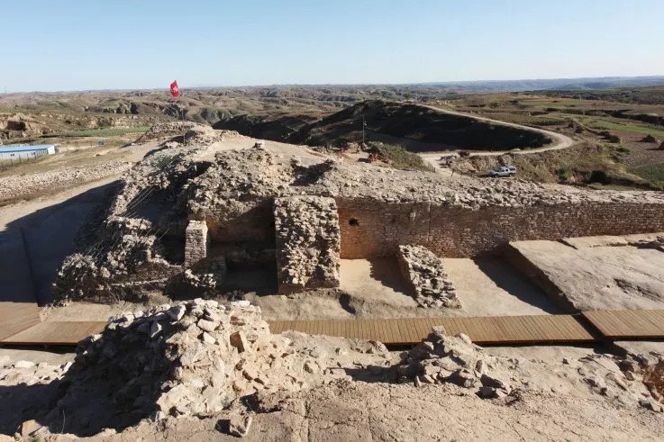
Archaeologists have discovered 16 burials at an ancient Egyptian site in the Taposiris Magna. The mummies were found to have a gold tongue. The team speculates that after the person’s tongue was removed during embalming it was replaced with the object so the deceased could speak to Osiris in the afterlife.
A god called Osiris is the Egyptian “Lord of the Underworld,” and he is one of the most powerful gods of the Ancient Egyptian. In other words, he is a judge of the dead
The burial shafts, dating back some 2,000 years, were popular in ancient Greek and Roman eras, which held remains inside of a mountain or natural rocky formation.
Within the tombs were a number of mummies and although the remains have since deteriorated, the stone funeral masks are still intact – allowing the team to see what each person may have once looked like.
The excavation is being led by the University of Santo Domingo, which has been working at the site for nearly a decade.
This 2,000-year-old mummy was buried with a golden tongue, likely to help the deceased speak in the afterlife.
A female mummy covered with a death mask from Alexandria, Egypt.
The team had previously uncovered several coins inside the Temple of Taposiris Magna etched with the face of Queen Cleopatra VII, which suggests she ruled when many of the individuals were laid to rest in their rock-cut tombs.
Additionally, pieces of statues and temple grounds reveal King Ptolemy IV built this spectacular temple.
Ptolemy IV Philopator reigned over Egypt from 221 to 204BC and due to his interest in lavish celebrations and ceremonies, the decline of the Ptolemaic dynasty is usually traced to him.
The other burials were not as preserved, but Dr. Kathleen Martinez, who is leading the dig, uncovered a number of luxurious trinkets and the statues over the tombs are intact – allowing experts to see who the people were
The skeleton with the gold tongue was found to be well-preserved, as its skull and most of its structure is still intact. Archaeologists dug it out of the rock-cut tomb and were met with the still shining gold object inside of the skeleton’s mouth.
They speculate that the tongue was removed by embalmers, but the gold tongue was put in its place during a funeral ritual. The hope is that this individual would have the ability to speak to the god of the dead, Osiris, upon arriving in the afterlife.
Kathleen Martinez, who is leading the dig, believes the site was strongly associated with the myth of Isis and Osiris – a myth that Cleopatra often tried to imitate during her life
Osiris is said to rule over the underworld and would judge the spirits of those who had died. And by giving the person who died some 2,000 years ago a tongue, may have allowed them to convince Orisis to show mercy on their spirit.
The other burials were not as preserved, but Dr. Kathleen Martinez, who is leading the dig, uncovered a number of luxurious trinkets and the statues over the tombs are intact – allowing experts to see who the people were.
One was found with remains of ‘gilding and bearing gilded decorations showing the god Osiris.’
Another was adorned with a stunning crown when they were laid to rest, which is decorated with horns, and a snake on the forehead that is most likely a cobra.
An additional symbol, depicting the god Horus, was found on the chest of one of the mummies. The symbol was incorporated in a decoration that represented a wide necklace from which a head of a falcon was hanging.
Dr. Khaled Abo El Hamd, the Director-General of The Alexandria Antiquities, said in a statement that ‘during this season the mission discovered a number of archaeological discoveries, the most important of which is a funeral mask for a woman, eight golden flakes representing the leaves of a golden wreath, and eight masks of marble dating back to the Greek and Roman eras.’
The Egyptian official also added that these masks ‘show high craftsmanship in sculpture and depiction of the features of its owners.’
Ancient China: Lost City With Pyramid and Human Sacrifices Is Rewriting History
Apparently, some archaeologists have uncovered the ruins of a lost city in China that were around for more than 3,000 years ago. On a hill above China’s Tuwei River, researchers found a large stepped pyramid that once served as a palace center, along with defensive stone walls, tool-making rubble, and many pits filled with sacrificial human skulls.
According to archaeologists, Bronze Age discoveries contradict our interpretation of early Chinese culture and occupation, indicating the loess highlands was home to a complex society long before the traditionally assumed ‘centers’ emerged in the Central Plains.
The ancient city dubbed Shimao was home to a pyramid that stood at least 230 feet tall (70 meters) and was guarded by a huge inner and outer wall.
Archaeologists have discovered the remains of a lost city in China that thrived more than 4,000 years ago. The pyramid was build out of a loess hill, with 11 massive steps tapering as they ascend, as shown above
Thousands of years ago when it flourished, from about 2300 BC to 1800 BC, the city spanned about 988 acres.
The pyramid was build-out of a loess hill, with 11 massive steps tapering as they ascend, the researchers write in a paper published in the journal Antiquity.
Beyond the entrance, they found a ‘large open plaza where rituals and political gatherings may have been held.’
According to the researchers, palaces were built atop the huge pyramid out of rammed earth with wooden pillars and roofing tiles.
The ancient city dubbed Shimao was home to a pyramid that stood at least 230 feet tall (70 meters), and was guarded by a huge inner and outer wall. Thousands of years ago when it flourished, from about 2300 BC to 1800 BC, the city spanned about 988 acres
On a ridge above China’s Tuwei River, the researcher found a massive stepped pyramid that once served as a palace center, along with defensive stone walls, tool-making debris, and a pit filled with sacrificial human skulls
It’s thought that the ruling elites lived atop the pyramid complex, which was likely also the site of artisanal or industrial craft production.
Eyes and anthropomorphic stone faces were found carved into the façade of the pyramid.
‘With its imposing height of at least 70 m, the pyramid could be seen from everywhere within the settlement, from the suburbs and even the rural fringes.
‘Thus it could well have provided a constant and overwhelming reminder to the Shimao population of the power of the ruling elites residing atop it – a concrete example of the ‘social pyramid.’
It’s thought that the ruling elites lived atop the pyramid complex, which was likely also the site of artisanal or industrial craft production
Researchers say mass sacrifices were also commonplace at Shimao, with six pits containing decapitated human heads discovered at the site on the outer rampart alone.
Human remains and jade objects associated with sacrifice were found at other Shimao monuments, as well.
‘The jade objects and human sacrifice may have imbued the very walls of Shimao with ritual and religious potency, amplifying its significance as a monumental center, enhancing the protective efficacy of the walls and making this a place of power in every sense,’ the authors wrote.
Beyond the entrance, they found a ‘large open plaza where rituals and political gatherings may have been held.’ According to the researchers, palaces were built atop the huge pyramid out of rammed earth with wooden pillars and roofing tiles
Notably, the researchers say the discoveries are indicative of Shimao’s status as a carefully constructed civilization.
‘This research reveals that by 2000 BC, the loess highland was home to a complex society representing the political and economic heartland,’ the authors wrote.
‘Significantly, it was found that Later Bronze Age core symbols associated with Central plains civilization were, in fact, created much earlier at Shimao.’
The Bronze Age discoveries challenge our understanding of early Chinese civilization and settlement, suggesting the loess highland was home to a complex society long before the traditionally assumed ‘centers’ emerged in the Central Plains
Geologists Map Secret Tunnel And Chamber Found Beneath Aztec Pyramid
“Teotihuacan, translated from the Aztec language as “birthplace of the gods,” or “a place where gods were born,” was a very important religious and cultural center during the Aztec empire.
Less than a decade ago, archaeologists uncovered an almost 60-foot Vertical shaft under the Avenue of the Dead.
Excavation of the tunnels beneath the Avenue was not possible, but in 2017 a team of geologists used electrical resistivity mapping to map the underground beneath the Avenue of the Dead.
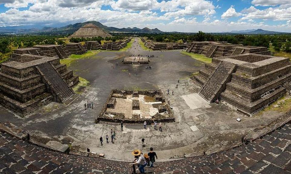
Panoramic view from the summit of the Pyramid of the Moon, with the “Avenue of the Dead”, in Teotihuacan.
This archaeological site in modern-day Mexico is famous for its broad central “Avenue of the Dead,” surrounded by a dozen pyramids and platforms. The 150 feet high Pyramid of the Moon was built in successive phases and construction completed between 200 and 250 CE. The nearby Pyramid of the Sun is even higher at 216 feet.
Excavation revealed a system of tunnels and chambers. Human remains and diverse objects made from green obsidian, a type of volcanic rock used in religious rituals, were recovered.
A worker removes dirt from a tunnel discovered under the Pyramid of the Plumed Serpent. So far, 70,000 objects of interest have been found there.
The extent of this tunnel-system remains uncertain to this day. Archaeologists suspected that the tunnels follow the pattern of the streets and pyramids on the surface.
As excavation of the complete site was not possible, in 2017 a team of geologists used electrical resistivity imaging to map the underground beneath the Avenue of the Dead.
Electrical resistivity imaging is a geophysical technique used also on other archaeological sites to map the composition of the underground, revealing large subterranean cavities or the presence of groundwater.
The researchers discovered a tunnel at a depth of 26 feet, that starting from the center of the avenue runs to 49 feet in diameter large cavity hidden beneath the Pyramid of the Moon.
Electrical resistivity data visualization under the Pyramid of the Moon.
The age and the use of this network of tunnels and chambers remain uncertain. The walls of the excavated tunnels were covered with pyrite powder.
Visitors would see the grains of this yellow mineral glitter in the light of torches, an effect resembling the stars of the celestial sphere. It was suggested that the tunnel-system acted as a symbolic gateway, connecting the sky with the underworld, and played an important role in religious rites.
The origin of the tunnel-system – and the city – are still being studied. Centuries later, the Aztecs built some towns on the site of the ancient city, but it’s not yet clear if they used the preexisting tunnel-system.
Around 300 CE, the tunnels appear to have been sealed off and nobody knows why or what the chamber may hide.
The Rome of America: What Lies Under Teotihuacan? – The Real City of the Gods
It was one of the first large cities in the Western Hemisphere, the Huge. And its origins are a mystery. About a thousand years before the gradual arrival in central Mexico of the Nahuatl-speaking Aztec, it was built by hand. But it was the Aztec, descending on the abandoned site, no doubt falling awestruck by what they saw, who gave its current name: Teotihuacan.
According to George Cowgill, an archaeologist at Arizona State University and a National Geographic Society grantee—Teotihuacan, a famous archaeological site less than 30 miles (50 kilometres) from Mexico City, Teotihuacan reached its zenith about 100 B.C. And A.D. 650.
It covered 8 square miles (21 square kilometres) and supported a population of a hundred thousand.
“It was the largest city anywhere in the Western Hemisphere before the 1400s,” Cowgill says. “It had thousands of residential compounds and scores of pyramid-temples … comparable to the largest pyramids of Egypt.”
Oddly, Teotihuacan, which contains a massive central road (the Street of the Dead) and buildings including the Temple of the Sun and the Temple of the Moon, has no military structures—though experts say the military and cultural wake of Teotihuacan was heavily felt throughout the region.
Who Built It?
Cowgill says the site’s visible surface remains have all been mapped in detail. But only some portions have been excavated.
Scholars once pointed to the Toltec culture. Others note that the Toltec peaked far later than Teotihuacan’s zenith, undermining that theory. Some scholars say the Totonac culture was responsible.
No matter its principal builders, evidence shows that Teotihuacan hosted a patchwork of cultures including the Maya, Mixtec, and Zapotec.
One theory says an erupting volcano forced a wave of immigrants into the Teotihuacan valley and that those refugees either built or bolstered the city.
The main excavations, performed by Professors Saburo Sugiyama of Aichi Prefectural University in Japan and Rubén Cabrera, a Mexican archaeologist, have been at the Pyramid of the Moon.
It was there, beneath layers of dirt and stone, that researchers realized the awe-inspiring craftsmanship of Teotihuacan’s architects was matched by a cultural penchant for brutality and human and animal sacrifice.
Inside the temple, researchers found buried animals and bodies, with heads that had been lobbed off, all thought to be offerings to gods or sanctification for successive layers of the pyramid as it was built.
Since 2003, archaeologist Sergio Gomez has been working to access new parts of the complex and has only recently reached the end of a tunnel that could hold a king’s tomb.
It’s unclear why Teotihuacan collapsed; one theory is that poorer classes carried out an internal uprising against the elite.
For Cowgill, who says more studies are needed to understand the lives of the poorer classes that inhabited Teotihuacan, the mystery lies not as much in who built the city or in why it fell.
“Rather than asking why Teotihuacan collapsed, it is more interesting to ask why it lasted so long,” he says. “What were the social, political, and religious practices that provided such stability?”
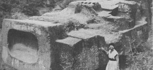
Megalithic stone blocks scattered in the vicinity of the pyramid of the Feathered Serpents at Teotihuacan.
Megalithic stone head from the earlier layer of construction.
Megalithic stone blocks scattered in the vicinity of the pyramid of the Feathered Serpents at Teotihuacan.
Megalithic stone blocks scattered in the vicinity of the pyramid of the Feathered Serpents at Teotihuacan.
Villa Epecuen: The Town That Was Submerged For 25 Years
The landscape has the permanent look of winter. Leafless trees jag skywards while shimmering white dust covers the ground. The streets are deserted; the only sound is the breeze. Welcome to Epecuen, Argentina’s ghost town, with a population of just one.
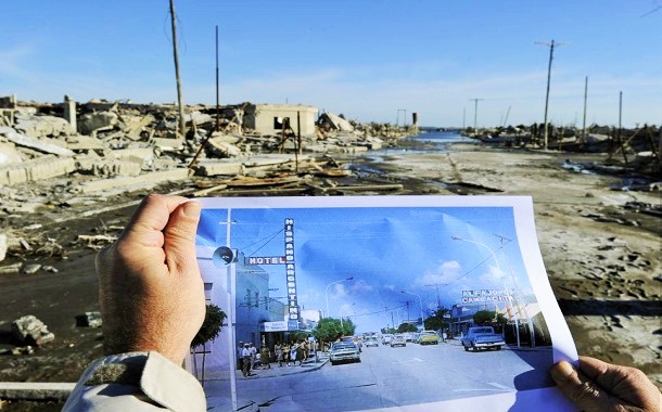
Located 340 miles south-west of Buenos Aires, Epecuen was once a booming tourist destination on the shores of a salt lake famed for its healing properties. Then one-day disaster struck. On 10 November 1985, after a period of heavy rain, the banks of the lake burst. The town, stretching back for more than 100 blocks, was submerged in water 10 meters deep.
Over the past few years, the waters have receded and the town has re-emerged. Left behind is a crystalline residue that from a distance looks like snow, as well as hundreds of dead trees and a derelict resort.
Lone inhabitant of Villa Epecuen, 81-year-old Pablo Novak tends his wood stove at his on May 3, 2011.
When the flood hit, residents were forced to pack their bags and leave. No one dared to return, except for 83-year-old Pablo Novak, who now has the dubious title of being contemporary Epecuen’s only resident. Today he’s out for a jaunt on his rusting bicycle with his two dogs in tow.
“I got used to life on my own,” he says. “I decided to stay because I spent my youth here, I went to school here and also started a family here. So it seemed quite normal.”
The former slaughterhouse of Villa Epecuen, Argentina, among a stand of long-dead trees, photographed on May 4, 2011.
Norma Berg gestures next to the ruins of her family house in Villa Epecuen, Argentina, on May 3, 2011.
A thin layer of salt, cracked, revealing the original paint of the wall of a collapsed building in Villa Epecuen, Argentina, on May 3, 2011.
The flood reduced Epecuen to rubble. No house was left untouched. Façades have disintegrated; walls have crumbled; pavements have sunk. Wooden staircases are exposed – in one spot are the rusting remains of a 1930s Chevrolet that an owner failed to salvage.
The salt has preserved tiny details, freezing the resort in time and allowing a voyeuristic glimpse into the past. Near the main street are the remains of a pizzeria. The sculptures that the owner bought to decorate his business are still intact, including a stone crescent moon sitting outside as though it were still 1985. In the rubble, a wood-fired pizza oven is clearly visible.
Walking among the crystalline ruins, the tracks left by a tractor that tried to salvage valuables from the long-gone Santa Teresista Church are still there. Dotted around the site, too, are green wine bottles half-buried in the sand. Further away from the main drag is what used to function as the municipal camping area. The eerie site has an abandoned playground: the frame of a set of swings still stands, as does a rusting seesaw, every inch reminiscent of Chernobyl.
Javier Andres, head of tourism for the normally sleepy agricultural region of Adolfo Alsina, has been swamped with interest in the last few weeks due to a concerted effort to promote the ruins. Epecuen has been compared to Pompeii, he says, but there is one major difference.
The road leading to the cemetery of Carhue, near Villa Epecuen, at sunset on May 4, 2011.
“We don’t think there’s anywhere in the world quite like it,” he explains. “Although it’s been called the Argentinian Pompeii, there you’re not able to walk around with a former resident explaining everything to you. Here you can do that.”
The waters began their retreat in 2009 but the tourist board delayed launching a campaign until now, respectful of the reactions the floods continue to provoke among the hundreds who lost their livelihoods.
“When you visit Epecuen, the sensation is hard to explain,” Mr. Andres says. “There’s a sense of wonder at this place that is completely in ruins, an apocalyptic vision. But then you can’t help thinking about the people that lost everything here, years of effort and hard work that disappeared overnight. So there’s a lot of sadness at the same time.”
The devastated landscape has attracted the attention of several movie crews and Roland Joffé’s Spanish Civil War drama, There Be Dragons, was partly filmed here. Yet the demise of Epecuen remains painful for former residents. The health resort was one of the most frequented in Argentina, growing in popularity from the 1920s and attracting European as well as local tourists at a time before the wide availability of alternative treatments.
The water – 10 times saltier than the sea – drew many of Buenos Aires’s Jewish community, nostalgic for the Dead Sea. The town’s population of just over 1,000 would swell fivefold during the high season.
“There are some things you can repair, such as the economic damage,” says Carlos Ruben Besagonill, 49, who used to run a hotel in Epecuen. “But you can’t replace the experiences, the affection, the moments you passed there.”
Mr. Besagonill says that it’s taken him more than 20 years to re-establish the business he had in Epecuen in nearby Carhue, now the region’s main tourist town. He was forced to leave behind everything in 1985, recently married and with a one-year-old daughter in his arms. “I used to dream every night that Epecuen reappeared,” he says. “I’d dream that I told my family: ‘Look we can go back and paint the hotel,’ because I really thought it was possible.”
Mr Besagonill is pleased that the ruins may soon be a major tourist attraction once more. For him, it should serve as a warning about “what not to do with nature”. He says that the province may be to blame for poor water management, but that the town should never have been built so close to the shores of a lake that was liable to overflow.
A man compares a photograph of Villa Epecuen taken in the 1970s with the current state of the place, after almost 25 years beneath the water of Lago Epecuen.
Back on the main street, the ghosts of Epecuen continue to swirl around the crumbling concrete as Mr. Novak recalls the ice-cream parlour he used to pass, the bar he’d visit for a beer, and the clubs where he’d dance until the early hours.
Mr. Novak says that his children don’t like coming back – unlike his 21 grandchildren who love hearing his yarns and devour his photos of the old days – and every year they try to convince him to move away. But while he remains independent, he argues, he’s going nowhere.
Although Mr. Andres rejects the idea that somebody may be prepared to stump up the “six-figure sum” needed to rebuild Epecuen, Mr. Novak remains dogged in his hope that the town will one day recapture its glorious past. “I always thought it would revive, that’s the thing I find most difficult,” he says wistfully. “I keep on hoping it will happen. But sadly no one seems to want to do anything.”
Remains Of Long-Lost Temple Of Musasir Discovered In Iraq
In an ancient stone carving, warriors brandishing shields and swords swarm over the columned facade of a grand temple. On one side, a palace stands with three women perched on top; on the other, above private homes, a ruler on a throne dictates to royal scribes. In the foreground, the peaks of northern Iraq soar.
For centuries, scholars and archaeologists have speculated about the whereabouts of this near-mythical temple and the powerful city where it resided. While they know its history, the storied city’s exact location has long been lost to time, until a recent report by a local archaeologist claimed to have hit upon the temple’s remains. Using clues pulled from surviving records and descriptions, Dlshad Marf Zamua believes that, after seven years of research, he’s found the last traces of Musasir in what is now a village called Mdjeser in Iraqi Kurdistan.
More than 2,500 years ago, the holy structure was the shining glory of the ancient capital city of Musarir, also known as Ardini, in modern-day Iraqi Kurdistan. For hundreds of years, around the first millennium BC, the house of worship and its home city was renowned as holy sites. Scholars believe that the temple was built in the late ninth century BC to honor the god Haldi—a winged warrior standing on a lion—and the goddess Bagbartu in the Iron Age kingdom of Urartu, which considered Haldi its national deity.
This ancient metropolis separated Urartu, a cross-section of Armenia, Iraq, eastern Turkey, and northwestern Iran, from the powerful empire of Assyria. The capital city had long been written about, first by an Assyrian king who said it was “the holy city founded in bedrock,” then by a later king who referred to the city’s ruler as a “mountain dweller,” and its own seal called it “the city of the raven.”
The adorned temple of Haldi was described as having multiple gates, where large numbers of animals were sacrificed. There was supposedly a courtyard, and scholars believe regional kings were crowned on its grounds, where they would later erect bronze statues in their own honor.
The region was a constant battleground for political powers in the Middle East, and in 714 B.C., the armies of Sargon II of Assyria captured and plundered the holy Musasir. Within the temple, they found a cache of treasure hoarded for centuries. The crusading king’s loot totaled an estimated one ton of gold and 10 tons of silver.
This was the eighth campaign for Sargo II, and one of the last major conquests led by a series of kings who would unite the Middle East under the rule of Assyria. Sargo II used claims of treachery by local rulers to justify the invasion, but it became clear that the vast wealth of the city was the real goal. He pledged the newfound riches to fund construction of “Sargon’s Fortress” the next year, with plans of making it the new center of Assyria, one of the great ancient empires. It was on the walls of Sargon II’s massive new palace that workers engraved scenes of the sacking of Masasir.
A 19th-century drawing of an ancient relief that depicts the sacking of the temple of Haldi by the Assyrians.
Several life-sized human statues of bearded males, dating back to the seventh or sixth centuries B.C., have also been discovered in Kurdistan.
In the carving, the temple is depicted with a classical pediment front and a colonnade of columns supporting the structure. If accurate, historians believe it could be the first known temple to use both those styles.
For the last 40 years, since they were unearthed during a military upheaval, local villagers in Mdjeser have been using these column bases in their homes and buildings, incorporating them into stairs, seats, or courtyard additions.
Marf Zamua, who teaches at Salahaddin University in Erbil, the capital of Iraqi Kurdistan, and is working on his PhD in Assyriology in the Netherlands, began collecting these recently exposed pieces. The 17 column fragments he’s found so far have led him to believe he’s discovered the long-lost temple. Along with these major finds are a collection of relics, seven stone statues, pottery, and a bronze depiction of a wild goat found in the area.
Life-size human statues and the remains of an ancient temple dating back some 2,500 years have been discovered in the Kurdistan region of northern Iraq. The region’s hilly environment, shown here.
It hasn’t been an easy task. Four decades of turmoil have devastated archaeological sites, but the chaos has also resurfaced previously buried treasures. Beginning in 2005, Marf Zamua began to document Late Bronze Age and Iron Age sites that were revealed during a period of unrest. He went from village to village looking for what had been uncovered. “Most of the objects [were] re-used for their daily life, such as using column bases as stairs and seats,” he remembers, “and statues as column stones in their houses.”
He also made a connection between architectural similarities between the modern village and the ancient city—idiosyncrasies in building styles that are uncommon elsewhere in the region, like the lack of outer compound walls and stacked houses. These findings were presented in June at the International Congress on the Archaeology of the Ancient Near East in Basel, Switzerland.
Paul Zimansky, a professor of archaeology and ancient history at Stony Brook University, says the general area has been thought to contain the mythic temple for many years. And while he’s not yet convinced of the temple’s discovery, he says the bases found “may well belong to some sort of public building of the appropriate time.” He calls Marf Zamua’s discoveries “a major contribution to the archaeology of this valley.”
“I hope he can continue his work in spite of all the political turmoil,” Zimansky says. “The remoteness of the area has been both its curse and its blessing throughout history.”
Uncovering these treasures in Iraq has posed a special set of challenges for excavators. The area saw the suspension of digs after the 1981 Gulf War, Marf Zamua says, when the Iranian and Iraqi armies sowed the earth with thousands of landmines. Later, Kurdish fighters clashed with Iran and Turkey, and Iraqi leader Saddam Hussein destroyed thousands of Kurdish villages, including Mdjeser.
As it goes, history is bound to repeat itself. Just as Sargon II plundered Urartu to fund his war chest, antiquities across Syria and Iraq have been bombed flat and looted by rebels and government forces alike. In Iraq, invading militants of the Islamic State of Iraq and al Sham have torn through Mosul’s museum and are destroying ancient treasures at an alarming rate.
Marf Zamua denounces the pillaging, but says the rebels have been targeting Islamic architecture and relics more than pre-Islamic sites. Luckily, the Kurdish army has been successfully protecting the border since the surge, and Marf Zamua says he’s unconcerned about the interference with his work—he and the local antiquities department are moving ahead with plans to launch fuller excavations into locations where the objects were found
But there’s no telling whether the remnants of a mythic temple built to honor a winged man on a lion’s back will survive its resurrection. “They destroy anything they do not like,” Marf Zamua says of the modern-day invaders.
A winged bull with a human head, found during excavations. Stored in the Louvre.
A 19th-century drawing of an ancient relief depicting the plundering of the temple by the Assyrians.
Sargon II with a nobleman.
Armenian priests – astrologers are the keepers of the eternal fire of wisdom and knowledge
Drawing 12 zodiac houses. The revolutionary Dudosimal (twelve) system of Armenian Chaldean astrologers
Heavenly bull Taurus. Esoteric cuneiform table of Chaldean astrologers. Instruction book of rules
Part of a broken cuneiform script about observing celestial bodies in order to predict the future on the basis of cosmic phenomena. Up to natural disasters
An extraordinary find: Ancient, underground Etruscan pyramids spotted in Italy
Archaeologists are scratching their heads about an underground pyramid-shaped structure they have been excavating beneath the historic medieval town of Orvieto in Italy. But it may not be a mystery forever. They hope to find answers as they continue to tease artifacts and architectural materials from the soil.
Ancient Etruscan Underground Pyramids Discovered in Italy
“We discovered it three summers ago and still have no idea what it is,” write Prof. David B. George of St. Anselm College and co-director Claudio Bizzarri of PAAO and colleagues about the site. “We do know what it is not. It is not a quarry; its walls are too well dressed. It is not a well or cistern; its walls have no evidence of hydraulic treatments.”
Calling it the “cavitá” (‘hole’ or ‘hollow’ in Italian), or hypogeum, the archaeologists have thus far excavated about 15 meters down.
They marked their third year at the site in 2014. By then they had uncovered significant amounts of what they classify as Gray and Black bucchero, common ware, and Red and Black Figure pottery remain. They have dated deposits to the middle to the end of the 6th century BCE.
“We know that the site was sealed toward the end of the 5th century BCE,” George, et al. continue. “It appears to have been a single event. Of great significance is the number of Etruscan language inscriptions that we have recovered – over a hundred and fifty. We are also finding an interesting array of architectural/decorative terra cotta.”
Excavation on the west wall of the hypogeum near the Etruscan tunnel that connects this pyramidal hypogeum (Room A) with an adjacent one (Room B).
Looking from Room B through the Etruscan tunnel into Room A
Above and below: The medieval columbarium – a place for raising pigeons – in the cavità used as a lab to sort bucchero.
Orvieto has long been known for its scenic medieval architecture. Located in southwestern Umbria, Italy, it is situated on the summit of a large butte of volcanic tuff, commanding a view of the surrounding countryside, and surrounded by defensive walls built of the same volcanic tuff.
Beneath it and in the surrounding areas of the medieval town, however, lie ancient Etruscan and Roman remains, a focus of archaeological investigations and excavations by various teams for decades.
George’s excavations have centered on four different sites in the area, two (Coriglia and the Orvieto underground structures) of which will be further excavated in the near future.
The Coriglia excavations have resulted in a wealth of finds, including monumental structures such as Etruscan and Roman walls, Etruscan and imported Greek ceramic materials, three large basins dated to the Roman Imperial period, and apsidal structures with associated features related to the management of water for baths or other purposes.
“We have uncovered evidence for occupation of the site dating from the 10th century BCE all the way to the 16th century CE, as well as random realia from World War II,” write George, et al.
View of Orvieto.
At Coriglia: Trench F showing a viscera with hydraulic cement and flooring with a collapsed vault to the right (Likely 2nd century CE). On the left a medieval industrial reuse of the structure.
‘Trench C’ showing the recently discovered caldarium of a Roman bath (Imperial period) at Coriglia
Overall, excavations under George and Bizzarri’s direction in the area have recovered monumental structures, sculptures, mosaics, coinage, inscriptions, ceramics, frescoes, and numerous other artifacts.
Looking forward, he anticipates new finds that will shed additional light and answer more questions about what the sites at Orvieto and Coriglia are all about.
“We are still trying to determine how the structure was ‘killed’ [filled in and then abandoned] – in a short period of time confined over the course of a few months or over a much longer period,” says George, referring to the cavitá.
“The tight dating of the Attic pottery seems to indicate a short period but the enormous quantity gives one pause. At Coriglia, our current hypothesis is that it is a sanctuary. We wish to test this by excavating in areas that should yield architectural and ceramic evidence that would be associated with such use.
We are still working on the phasing of our walls and getting a handle on three periods of expansion, at least one of which followed a mudslide.”
Even more important, however, maybe what their findings will ultimately say about the lives of people in the region so long ago. Write George, Bizzarri, and colleagues, “based on what is known from similar sites in the region, the members of our archaeological expedition may be confident that they will make discoveries that will reflect daily life in the Etruscan and Roman periods.”
Archaeologists on HS2 line uncover grounds of perfectly preserved 16th-century manor gardens
The remains of beautiful gardens belonging to a 16th-century manor house have been uncovered by archaeologists clearing ground for the high-speed HS2 rail line. The finding, near Coleshill on the outskirts of Birmingham, has been dubbed ‘Warwickshire’s answer to Hampton Court’.
Through a continuous excavation alongside the ruins of Coleshill Manor and its octagonal moat, which were first picked up by archaeologists two years ago, evidence of the large ornamental garden was discovered. Sir Robert Digby, who owned the house in its heyday, is thought to have married an Irish heiress and designed the 1,000 feet (300 m) long gardens to display his wealth and status.
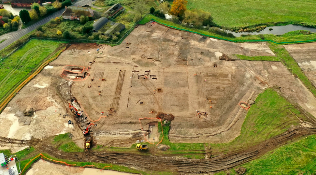
HS2 and its archaeologist partners Wessex Archaeology have now released drone images of the area showing the outline of the enormous garden. Stunning aerial photos show well-preserved gravel paths, planting beds, garden pavilion foundations, and ornaments organized in a geometric pattern.
Archaeologists clearing land for the high speed HS2 train line have unearthed the remnants of stunning gardens belonging to a 16th century manor house
Evidence of the large ornamental garden has been found by an ongoing dig alongside the remains of Coleshill Manor and its octagonal moat which were first picked up by archaeologists two years ago
This artist’s impression shows how the Coleshill Manor and its octagonal moat would have contained the lavish gardens around the year 1600
The 500-year-old site has drawn comparisons to London’s Hampton Court Palace and Kenilworth Castle and has been described as ‘one of the most exciting Elizabethan gardens’ ever found in England. Dr. Paul Stamper is a specialist in English gardens and landscape history and works at the University of Leicester.
He said: ‘This is one of the most exciting Elizabethan gardens that’s ever been discovered in this country.
‘The scale of preservation at this site is really exceptional and is adding considerably to our knowledge of English gardens around 1600.
‘There have only been three or four investigations of gardens of this scale over the last 30 years, including Hampton Court, Kirby in Northamptonshire, and Kenilworth Castle, but this one was entirely unknown.
‘The garden doesn’t appear in historical records, there are no plans of it, it’s not mentioned in any letters or visitors’ accounts.
‘The form of the gardens suggest they were designed around 1600, which fits in exactly with the documentary evidence we have about the Digby family that lived here.
‘Sir Robert Digby married an Irish heiress, raising him to the ranks of the aristocracy.
‘We suspect he rebuilt his house and laid out the huge formal gardens measuring 300 meters from end to end, signifying his wealth.’
Excavations are ongoing at the HS2 site to learn more about the Coleshill Manor, its moat, and the newly-discovered gardens
A Wessex Archaeologist show post medieval pottery from the Coleshill Medieval Manor site
HS2’s Historic Environment Manager, Jon Millward said: ‘It’s fantastic to see HS2’s huge archaeology programme making another major contribution to our understanding of British history.
‘This is an incredibly exciting site, and the team has made some important new discoveries that unlock more of Britain’s past.’
Wessex Archaeology’s Project Officer, Stuart Pierson added: ‘For the dedicated fieldwork team working on this site, it’s a once in a career opportunity to work on such an extensive garden and manor site, which spans 500 years.
‘Evidence of expansive formal gardens of national significance and hints of connections to Elizabeth I and the civil war provide us with a fascinating insight into the importance of Coleshill and its surrounding landscape.
‘From our original trench evaluation work, we knew there were gardens, but we had no idea how extensive the site would be.
‘As work has progressed, it’s been particularly interesting to discover how the gardens have been changed and adapted over time with different styles.
‘We’ve also uncovered structures such as pavilions and some exceptional artifacts including smoking pipes, coins, and musket balls, giving us an insight into the lives of people who lived here.
‘The preservation of the gardens is unparalleled.
‘We’ve had a big team of up to 35 archaeologists working on this site over the last two years conducting trench evaluations, geophysical work, and drone surveys as well as the archaeological excavations.’
Evidence of the manor, known as Coleshill Hall, and its previous occupants point towards a great feud between the Digby family and their rivals, the famed de Montfort clan, who now have a university named after them.
The hall came into the hands of Simon Digby in the late 15th century and the change of ownership set in motion huge alterations to the landscape around Coleshill and the hall, including a deer park and the formal gardens.
Excavations have revealed structures dating to the late medieval period, with evidence of a large gatehouse alluding to a possible 14th or 15th-century date.