Decapitated Skeletons, with Heads Between Their Legs, Unearthed in Roman Cemetery
Archaeologists discovered that a third of the skeletons were decapitated at a fourth-century Roman grave site in England, an unusually high percentage, even for the Roman Empire.
“Low proportions of decapitated burials are a common component of Roman cemeteries,” said Andy Peachey, an archaeologist at the site, to the East Anglian Daily Times. “It is rare to find such a high proportion of decapitated burials in Britain… Perhaps only half a dozen other sites in Britain demonstrate this.”
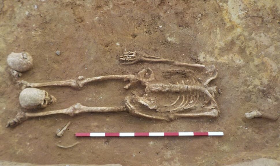
Out of the 52 skeletons archaeologists have identified in Suffolk county’s Great Whelnetham village, 17 are decapitated with their head placed between their legs. These beheadings occurred after the people had already died—meaning that none of them was executed in this fashion.
A decapitated Roman burial with the head placed between the feet, and a second human skull possibly from an adjacent grave.
Cleaning and recording Roman burials by the Archeological Solutions team. Out of the 52 skeletons archaeologists have identified in Suffolk county’s Great Whelnetham village, 17 are decapitated with their head placed between their legs.
“This appears to be a careful funeral rite that may be associated with a particular group within the local population, possibly associated with a belief system (cult) or a practice that came with a group moved into the area,” Peachey said.
The 17 beheaded skeletons are male and female, with one belonging to a child around nine or ten years old.
Most of the 52 skeletons in the graveyard are middle-aged or older. They show signs of poor dental hygiene but were well-nourished. Some of them had tuberculosis.
The reason archaeologists examined the site in the first place is that there is a planned housing development there. In Europe, archaeological discoveries are often made in preparation for public works projects.
That’s how researchers found a pair of medieval thigh-high boots in the mud of the River Thames, an ancient Roman library in Germany and a motley collection of artefacts in the city of Rome.
Archaeologists are still studying the skeletons in Great Whelnetham and will publish a report on their findings when they have finished. Until then, it’s difficult to speculate on why these 17 skeletons were singled out for beheading rites; previous examples of Roman beheadings don’t necessarily shed light on the reason these skeletons were decapitated.
In the city of York, England, there’s a second- and third-century Roman grave site where most of the 80-some skeletons were decapitated. Researchers found that these decapitated people migrated to York from as far away as modern-day Syria or Palestine.
But unlike the Great Whelnetham skeletons, the decapitated skeletons of York were all men whose remains suggest they were gladiators or soldiers. For some of them, decapitation probably was the way they died.
The skeletons at Great Whelnetham seem to have met a gentler fate.
An Ancient Papyrus Reveals How The Great Pyramid of Giza Was Built
Stones of up to fifteen tonnes were shipped to a man-made port on wooden boats across the Nile. It has been one of the major enigmas of the world for centuries: how did a simple culture with no sophistication build Giza’s Great Pyramid.
The earliest and only survivor of the Ancient World’s Seven Wonders? It was the tallest man-made building on Earth for almost 4,000 years, at 146 metres high.
Archaeologists also discovered the diary of Merer, an official involved in the building of Giza’s great pyramid, in what is regarded by some to be one of the greatest discoveries in Egypt in the 21st century.
The 4,500-year-old papyrus is the oldest in the world and describes how wooden boats and ingenious system of waterworks transported blocks of limestones and granite weighing up to 15 tonnes from 13 kilometres away. In it, Merer (which means beloved) describes how he and a crew of 40 elite workmen shipped the stones downstream from Tura to Giza along the Nile River.
In the last few years, the papyrus and other archaeological excavations have revealed new information about how the pyramids were constructed. Here are some of the findings uncovered in Nature of Things documentary Lost Secrets of the Pyramid.
A papyrus Tallet found at Wadi al-Jarf from 2,600 B.C., the world’s oldest, refers to the “horizon of Khufu,” or the Great Pyramid at Giza.
Water was harnessed to transport huge stones.
Every summer, when the Nile flooded, giant dykes were opened to divert water from the river and channel it to the pyramid through a manmade canal system creating an inland port which allowed boats to dock very close to the worksite — just a few hundred metres away from the growing pyramid.
A recreation of the port from the documentary Lost Secrets of the Pyramid
The construction of artificial ports was a huge turning point for Egyptians, opening up trade and new relationships with people from distant lands.
Wooden boats built with rope instead of nails.
The limestone was carried along the River Nile in wooden boats built with planks and rope that were capable of hauling two-and-a-half tonne stones.
Using ancient tomb carvings and the remains of an ancient dismantled ship as a guide, archaeologist Mohamed Abd El-Maguid has recreated one Egyptian boat from scratch.
3D scans of the ship planks revealed that the boats were full of holes that lined up perfectly with each other. Instead of nails or wood pegs, these boats were sewn together with rope like a giant jigsaw puzzle.
With 1,000 holes and five kilometres of rope the new boat was assembled and Abd El-Maguid and in Secrets of the Pyramid, attempts to re-create every step of Merer’s journey down the Nile with two-tonne limestone rock.
These boats were rowed carefully with the current down the Nile to the worksite. Once the rocks were unloaded, the wind helped propel the vessel back to the quarry.
Workers were valued and lived nearby in a huge settlement
Archaeologist Mark Lehner has uncovered artefacts that provide evidence of a vast settlement that held as many as 20,000 people. Average workers lived in huge dormitories, but team leaders like Merer lived in relative luxury with homes of their own.
Thousands of tiny bits of detritus of everyday life reveal that these hungry workers were well taken care of. An entire city was formed near the pyramid site to provide food and drink.
For most of the workers, building the pyramids was a source of prestige; these people have valued servants of the state.
Workers belonged to teams
Ankhhaf, Pharoah Khufu’s half-brother is mentioned in Merer’s diary and is thought to have been in charge of the operation. He divided the workforce into ‘phyles’ teams of 40 men — of which someone like Merer oversaw.
Artefacts with team names on them have been discovered by archaeologist Pierre Tallet at a remote desert outpost in Wadi Al-Jarf about 250 kilometres away. Merer’s phyle was called “The Followers of the Boat named after the Snake on its Figurehead.”
Four phyles formed a gang of elite labourers. Each team has specific roles in the construction of the pyramid or the transportation of materials to the worksite.
Thousands of men, working together for over 20 years, succeeded in building the tallest, heaviest structure on earth. They transformed the landscape, and in doing so, also created a new society which archaeologist Mark Lehner says is the real achievement, “Once they had put all these systems and all this infrastructure in place there was no going back. They became more important than the pyramid itself and set Egyptian civilization off on a course for the next two or three millennia.”
A 520-Million-Year-Old Five-Eyed Fossil Reveals Arthropod Origin
Since the Cambrian Period, around 520 million years ago, arthropods have been among the most prolific animals on Earth. They are the most familiar and ubiquitous, and constitute nearly 80 per cent of all animal species today, far more than any other animals.
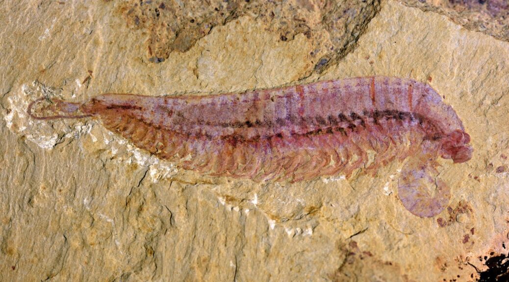
Ecological reconstruction of Kylinxia zhangi.
So how did arthropods evolve and what did they look like to their ancestors? This has been a major conundrum in animal evolution puzzling generations of scientists for more than a century.
A shrimp-like fossil with five eyes has now been found by researchers from the Nanjing Institute of Geology and Palaeontology of the Chinese Academy of Sciences (NIGPAS), giving valuable insights into the early evolutionary history of arthropods. The study was published in Nature on November 4, 2020.
Anatomical reconstruction of Kylinxia.
The fossil species, Kylinxia, was collected from the Chengjiang fauna in southwest China’s Yunnan Province. The fauna documents the most complete early animal fossils in the Cambrian time.
Prof. HUANG Diying, the corresponding author for the study from NIGPAS, said, “Kylinxia is a very rare chimeric species. It combines morphological features from different animals, which is analogous to ‘kylin,’ a chimeric creature in traditional Chinese mythology.”
“Owing to very special taphonomic conditions, the Kylinxia fossils exhibit exquisite anatomical structures. For example, nervous tissue, eyes and digestive system — these are soft body parts we usually cannot see in conventional fossils,” said Prof. ZHAO Fangchen, co-corresponding author of the study.
Kylinxia shows distinctive features of true arthropods, such as a hardened cuticle, a segmented trunk and jointed legs.
However, it also integrates the morphological characteristics present in very ancestral forms, including the bizarre five eyes of Opabinia, known as the Cambrian “weird wonder,” as well as the iconic raptorial appendages of Anomalocaris, the giant apex predator in the Cambrian ocean.
Holotype of Kylinxia zhangi.
Among the Chengjiang fauna, Anomalocaris is a top predator that can reach two meters in body length and has been regarded as an ancestral form of arthropod.
But huge morphological differences exist between Anomalocaris and true arthropods. There is a great evolutionary gap between the two that can hardly be bridged. This gap has become a crucial “missing link” in the origin of arthropods.
The research team conducted detailed anatomical examinations of the fossils of Kylinxia. They demonstrated that the first appendages in Anomalocaris and true arthropods were homologous.
The phylogenetic analyses suggested that there was an affinity between the front appendages of Kylinxia, small predatory appendages in front of the mouth of Chelicerata (a group that includes spiders and scorpions) and the antennae of Mandibulata (a subdivision of arthropods including insects such as ants and bees).
“Our results indicate that the evolutionary placement of Kylinxia is right between Anomalocaris and the true arthropods. Therefore, our finding reached the evolutionary root of the true arthropods,” said Prof. ZHU Maoyan, a co-author of the study.
“Kylinxia represents a crucial transitional fossil predicted by Darwin’s evolutionary theory. It bridges the evolutionary gap from Anomalocaris to true arthropods and forms a key “missing link” in the origin of arthropods, contributing strong fossil evidence for the evolutionary theory of life,” said Dr. ZENG Han, first author of the study.
Rare Ancient Child Burial Reveals 8,000-Year-Old Secrets of the Dead
Humanity has done a pretty good job of recording its collective history over the past two or three thousand years. Earlier time periods, though, are still very much shrouded in mystery. Now, a groundbreaking new archaeological discovery in Indonesia is revealing secrets from 8,000 years ago.
Entrance to Makpan cave, Alor Island, where the burial was discovered.
Archaeologists from The Australian National University have discovered an ancient child burial site located on Alor Island, Indonesia. While a funeral for a child is no doubt a morose and depressing event in any century, this unearthing is providing some invaluable insight on early mid-Holocene era cultural and burial practices.
Stunning burial practices unearthed
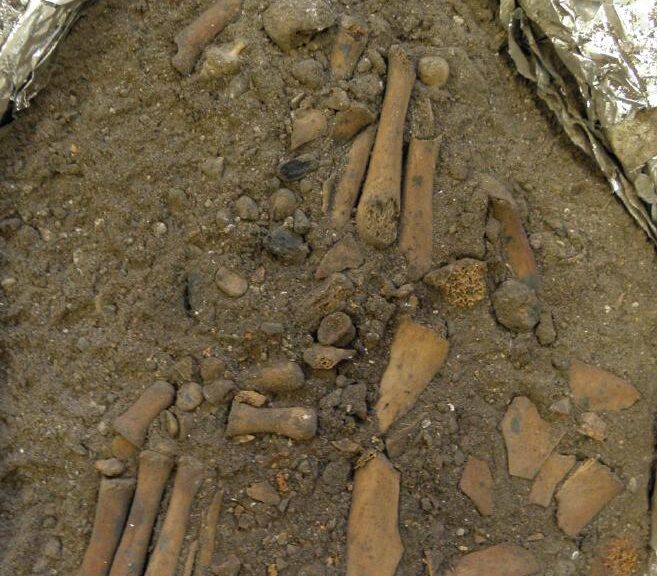
Articulated left foot (bottom left) and right foot (center) excavated in the ANU laboratory.
According to lead researcher Dr Sofia Samper Carro, it’s clear that the child was laid to rest with a formal ceremony of some kind. The research team estimates the child was between four and eight-years-old at the time of death.
“Ochre pigment was applied to the cheeks and forehead and an ochre-coloured cobblestone was placed under the child’s head when they were buried,” she says in a university release. “Child burials are very rare and this complete burial is the only one from this time period,”
“From 3,000 years ago to modern times, we start seeing more child burials and these are very well studied. But, with nothing from the early Holocene period, we just don’t know how people of this era treated their dead children. This find will change that.”
Of particular note is the fact that the child’s arms and legs appear to have been removed and stored elsewhere before the rest of the body was buried. This sounds rather odd from a modern perspective, but researchers say it isn’t wholly unprecedented.
“The lack of long bones is a practice that has been documented in several other burials from a similar time period in Java, Borneo and Flores, but this is the first time we have seen it in a child’s burial,” Dr Carro adds.
Why did ancient cultures remove arms and legs before burials?
The answer is probably lost to the sands of time, but researchers theorize some form of religion or spiritual belief is a likely explanation.
“We don’t know why long bone removal was practised, but it’s likely some aspect of the belief system of the people who lived at this time,” Carro adds.
While teeth examinations project the child as being around six to eight-years-old, the full skeleton appears to be closer to four or five-years-old.
“We want to do some further paleo-health research to find out if this smaller skeleton is related to diet or the environment or possibly to being genetically isolated on an island,” the lead researcher comments. “My earlier work from Alor showed adult skulls were also small.
These hunter-gatherers had a mainly marine diet and there is evidence to suggest protein saturation from a single food source can cause symptoms of mal-nourishment, which affects growth. However, they could have been eating other terrestrial resources such as tubers.”
“By comparing other adult burials we have found from the same time period with this child burial in a future project, we hope to build a chronology and general view of burial practices in this region from between 12,000 to 7,000 years ago which at the moment is still scant.”
Long-lost Maya capital discovered in a backyard in Mexico
Archaeologists claim that they discovered the long-lost capital of an ancient Maya kingdom on the Mexico-Guatemalan border.
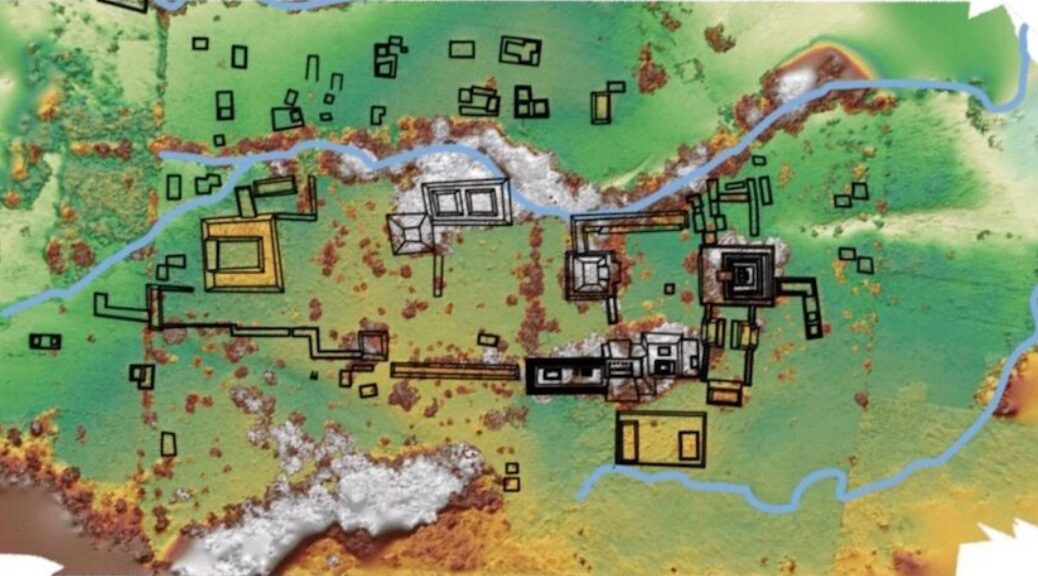
Schroder (left) and Scherer (right) excavate in the ancient city’s ballcourt. (Charles Golden)
In what is now Chiapas, Mexico, the Sak Tz’i Kingdom has 5,000-10,000 inhabitants from around 750 BCE by 900 AD, an associate professor of anthropology at Brandeis University, Charles Golden, said to LiveScience.
Golden said the empire was not particularly powerful and was surrounded by some of the superpowers of the day. He said that in inscriptions found in other cities, the Sak Tz’i’ kingdom was frequently mentioned.
“The reason we know about the kingdom from the inscriptions is that they get beat up by all these superpowers, their rulers are taken captive, they’re fighting wars, but they’re also negotiating alliances with those superpowers at the same time,” he said.
The downtown area was about a third of a mile long and a quarter-mile wide (600 meters by 400 meters) and had pyramids, a royal palace, a ball court and a number of houses.
“These are not big empires. They’re small city-states trying to carve out their little, little territories,” Golden said.
Golden and Brown University bioarchaeologist Andrew Scherer is leading the team that has been excavating the site since 2018. They published their findings in the Journal of Field Archaeology.
Golden said they found out about the site after graduate student Whittaker Schroder got a tip from a street food vendor, who introduced him to the rancher who owned the property.
The rancher had a stone tablet that had an inscription and a drawing of a Sak Tz’i’ king dressed as the Maya storm god.
Researchers made a drawing, left, and 3d model of the stone tablet.
Golden said the site had been raided by looters in 1960s and many of its monuments were stolen. The owner found the stone tablet in some rubble while working to protect what is left of the site.
“He found it by accident. There’s a lucky, lucky rescued object the looters had missed,” Golden said.
Golden said the looters used saws and other heavy equipment to cut the off faces of the monuments. The pieces wound up in museums and private collections around the world.
“When you go to the museum and see these objects, you’re seeing something that’s been really butchered from its original piece of stone, so we would try to reconnect it to the original piece of stone that may still be on on-site,” he said.
He said it’s taken years to build trust in the community and get permission to dig at the site.
“We are both excavating to find out how people lived and more about how they built these places, but we also have to conserve these buildings,” Golden said. “They were damaged by looters and we’ll be working with the landowner to stabilize and keep these buildings from further deterioration.”
He said he hopes the discovery will help them learn how these smaller kingdoms and their citizens lived their lives and negotiated to live between their powerful, feuding neighbours.
7,000 years old Australian Aboriginal Sites Discovered Underwater
According to a report released July 1 , 2020, in the open-access journal PLOS ONE by Jonathan Benjamin of Flinders University, Adelaide, Australia and colleagues, ancient submerged Aboriginal archaeological sites await underwater rediscovery off the coast of Australia.
Sea levels were about 80 metres lower than today when humans first settled in Australia as early as 65,000 years ago. As the global atmosphere cooled, sea levels fluctuated but continued to fall.
As the world plunged into the last ice age, which peaked around 20,000 years ago, sea levels dropped to 130 metres lower than they are now.
Between 18,000 and 8,000 years ago the world warmed up. Melting ice sheets caused sea levels to rise. Tasmania was cut off from the mainland around 11,000 years ago. New Guinea separated from Australia around 8,000 years ago.
The sea-level rise flooded 2.12 million square kilometres of land on the continental shelf surrounding Australia. Thousands of generations of people would have lived out their lives on these landscapes now underwater.
In this study, Benjamin and colleagues report the results of several field campaigns between 2017-2019 during which they applied a series of techniques for locating and investigating submerged archaeological sites, including aerial and underwater remote sensing technologies as well as a direct investigation by divers.
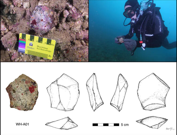
Site location in northwest Australia, left, and the Dampier Archipelago, right.
They investigated two sites off the Murujuga coastline of northwest Australia.
In Cape Bruguieres Channel, divers identified 269 artefacts dating to at least 7,000 years old, and a single artefact was identified in a freshwater spring in Flying Foam Passage, dated to at least 8,500 years old. These are the first confirmed underwater archaeological sites found on Australia’s continental shelf.
A selection of stone artefacts found on the seabed.
A stone tool associated with a freshwater spring, now 14m underwater.
These findings demonstrate the utility of these exploratory techniques for locating submerged archaeological sites.
The authors hope that these techniques can be expanded upon in the future for systematic recovery and investigation of ancient Aboriginal cultural artefacts.
They further urge that future exploration will rely not only on careful and safe scientific procedures but also on legislation to protect and manage Aboriginal cultural heritage along the Australian coastline.
Benjamin says, “Managing, investigating and understanding the archaeology of the Australian continental shelf in partnership with Aboriginal and Torres Strait Islander traditional owners and custodians is one of the last frontiers in Australian archaeology.” He adds, “Our results represent the first step in a journey of discovery to explore the potential of archaeology on the continental shelves which can fill a major gap in the human history of the continent.”
The first-ever portrait of Jesus Christ in Israel Discovered, 70 ancient books hidden in a cave for nearly 2,000 years
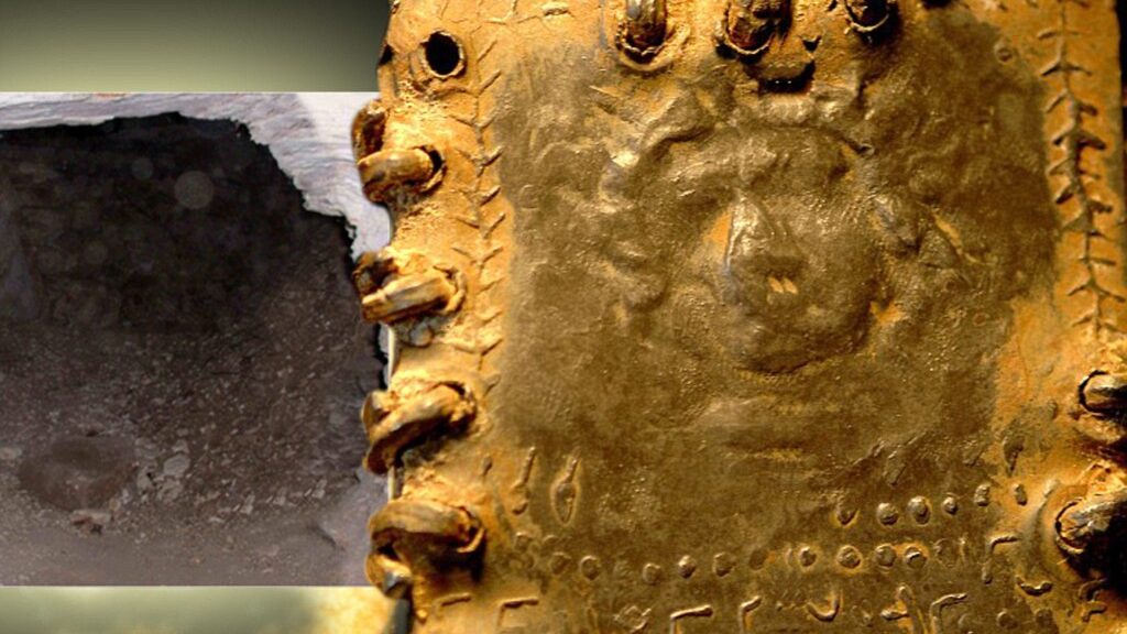
The image is eerily familiar: a bearded young man with flowing curly hair. After lying for nearly 2,000 years hidden in a cave in the Holy Land, the fine detail is difficult to determine. But in a certain light, it is not difficult to interpret the marks around the figure’s brow as a crown of thorns.
The extraordinary picture of one of the recently discovered hoards of up to 70 lead codices – booklets – found in a cave in the hills overlooking the Sea of Galilee is one reason Bible historians are clamouring to get their hands on the ancient artefacts.
If genuine, this could be the first-ever portrait of Jesus Christ, possibly even created in the lifetime of those who knew him.
Discovery: The impression on this booklet cover shows what could be the earliest image of Christ
The tiny booklet, a little smaller than a modern credit card, is sealed on all sides and has a three-dimensional representation of a human head on both the front and the back. One appears to have a beard and the other is without. Even the maker’s fingerprint can be seen in the lead impression. Beneath both figures is a line of as-yet undeciphered text in an ancient Hebrew script.
Astonishingly, one of the booklets appears to bear the words ‘Saviour of Israel’ – one of the few phrases so far translated.
The owner of the cache is Bedouin trucker Hassan Saida who lives in the Arab village of Umm al-Ghanim, Shibli. He has refused to sell the booklets but two samples were sent to England and Switzerland for testing.
An investigation has revealed that the artefacts were originally found in a cave in the village of Saham in Jordan, close to where Israel, Jordan and Syria’s Golan Heights converge – and within three miles of the Israeli spa and hot springs of Hamat Gader, a religious site for thousands of years.
Precious: This booklet shows what scholars believe to be the map of Christian Jerusalem
According to sources in Saham, they were discovered five years ago after a flash flood scoured away the dusty mountain soil to reveal what looked like a large capstone. When this was levered aside, a cave was discovered with a large number of small niches set into the walls. Each of these niches contained a booklet. There were also other objects, including some metal plates and rolled lead scrolls.
The area is renowned as an age-old refuge for ancient Jews fleeing the bloody aftermath of a series of revolts against the Roman empire in the First and early Second Century AD.
The cave is less than 100 miles from Qumran, where the Dead Sea Scrolls were discovered, and around 60 miles from Masada, scene of the last stand and mass suicide of an extremist Zealot sect in the face of a Roman Army siege in 72AD – two years after the destruction of the Second Temple in Jerusalem.
It is also close to caves that have been used as sanctuaries by refugees from the Bar Kokhba revolt, the third and final Jewish revolt against the Roman Empire in 132AD.
The era is of critical importance to Biblical scholars because it encompasses the political, social and religious upheavals that led to the split between Judaism and Christianity.
It ended with the triumph of Christianity over its rivals as the dominant new religion first for dissident Jews and then for Gentiles.
In this context, it is important that while the Dead Sea Scrolls are rolled pieces of parchment or papyrus containing the earliest-known versions of books of the Hebrew Bible and other texts – the traditional Jewish format for written work – these lead discoveries are in book, or codex, a form which has long been associated with the rise of Christianity.
The codices seen range in size from smaller than 3in x 2in to around 10in x 8in. They each contain an average of eight or nine pages and appear to be cast, rather than inscribed, with images on both sides and bound with lead-ring bindings. Many of them were severely corroded when they were first discovered, although it has been possible to open them with care.
The codex showing what may be the face of Christ is not thought to have been opened yet. Some codices show signs of having been buried – although this could simply be the detritus resulting from lying in a cave for hundreds of years.
Unlike the Dead Sea Scrolls, the lead codices appear to consist of stylised pictures, rather than text, with a relatively small amount of script that appears to be in a Phoenician language, although the exact dialect is yet to be identified. At the time these codices were created, the Holy Land was populated by different sects, including Essenes, Samaritans, Pharisees, Sadducees, Dositheans and Nazoreans.
One lucky owner: Hassan Saida with some of the artefacts that he says he inherited
There was no common script and considerable intermingling of language and writing systems between groups. Which means it could take years of detailed scholarship to accurately interpret the codices.
Many of the books are sealed on all sides with metal rings, suggesting they were not intended to be opened. This could be because they contained holy words which should never be read.
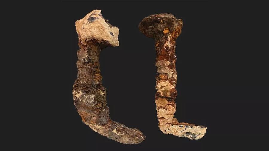
A Scientist Thinks These Ancient Roman Nails May Have Been Used To Crucify Jesus Christ
According to a new analysis, two corroded Roman-era iron nails which some have claimed pinned Jesus to the cross seem to have been used in an ancient crucifixion. The controversy about the origin of the nails was reignited by this study.
The two Roman-era iron nails are from an unmarked box delivered to Tel Aviv University; new research suggests they could be the two nails lost from the tomb of the Jewish high priest Caiaphas, who presided over the condemnation of Jesus.
The latest research indicates that the nails of the tomb of the Jewish high priest Caiaphas, who supposedly handed Jesus over for execution to the Romans for execution. Slivers of wood and bone fragments suggest they may have been used in a crucifixion.
The connection to Caiaphas and the new evidence did not completely show that the nails were used to crucify Jesus in Jerusalem in A.D. 33, Geologist Aryeh Shimron, the lead author of the study published in the journal Archaeological Discovery.
“I certainly do not want to say that these nails are from the crucifixion of Jesus of Nazareth,” Shimron told Live Science. “But are they nails from a crucifixion? Very likely, yes.”
Where did the nails originate?
One of the nails was purportedly found in one of the 12 ossuaries within Caiaphas’ tomb, while the other was found on the ground nearby.
Israel Hershkovitz, a renowned anthropologist at Tel Aviv University, received the nails in an unmarked box from the collection of Nicu Haas, an Israeli anthropologist who died in 1986. According to the Israel Antiquities Authority (IAA), Haas obtained them from a tomb excavated in the 1970s, decades before the Caiaphas tomb was discovered, according to Haaretz.
But the IAA doesn’t know which tomb the nails came from, and no records of their provenance have ever been found. In a controversial 2011 documentary called “The Nails of the Cross,” however, filmmaker and journalist Simcha Jacobovici suggested the nails were those lost from the Caiaphas tomb — and that the high priest may have been so overcome with guilt about the crucifixion of Jesus that he kept the nails as a memento.
Haaretz reported that some scholars, though no names were given, have called the latest research highly speculative. But Shimron, a geologist based in Jerusalem who’s retired from the Israel Geological Survey, said the new study gave weight to the documentary’s ideas. Shimron has not studied the two nails that are the subject of Jacobovici’s 2011 documentary before now, though he was involved in a 2015 study tied to another of Jacobovici’s controversial documentaries on the archaeology of Jesus.
The nails are long enough to have been driven through a person’s palms — and the fact that they are bent upward is consistent with crucifixion.
Workers widening a road discovered the first-century “Caiaphas” tomb in 1990 in a neighbourhood in the southeast of Jerusalem. The tomb contained 12 ossuaries —– one marked with the name “Qayafa” and another, ornately decorated with motifs of flowers, marked with the Aramaic name “Yehosef Bar Qayafa,” or “Joseph son of Caiaphas” in English. Most archaeologists now accept that the tomb was used to bury the first-century high priest Caiaphas and his family, the study said.
Caiaphas, who is is mentioned several times in both the Christian New Testament and history of the Jews written in the late first century by Flavius Josephus, presided over a sham trial of Jesus for blasphemy, after which Jesus was handed over to the Roman governor Pontius Pilate for execution, according to the Gospel of Matthew. The execution was reportedly carried out on Friday, April 3, 33, when Jesus was nailed to the cross — a common Roman method of capital punishment.
The two nails discovered at Tel Aviv University match the chemical signature of the ossuaries in the Caiaphas tomb and have traces of an unusual fungus found there.
Jerusalem tomb
In the latest study, Shimron and his co-authors compared samples from the two nails with sediments from the ossuaries in the Caiaphas tombstone chests used to hold the bones of people after they had decayed for about a year on a rock shelf. It found that not only did the physical and chemical signatures of the nails and the ossuaries match, but they also seemed to be unique.
For example, the ratios of isotopes of carbon and oxygen — variants of these elements — in both sets of samples suggested they both came from an abnormally humid environment, and they both had significant “flowstone deposits” —– layers of calcite carbonate formed by flowing water.
These findings match the conditions in the Caiaphas tomb, which is located near an ancient aqueduct and often would have been flooded by its overflow. The researchers also found evidence on both the nails and the ossuaries of a specific fungus — an unusual type of yeast — that grows only in very damp conditions and has been found in no other tomb in Jerusalem. “I think the nails came from that tomb,” Shimron said.
Their analysis of the nails with an electron microscope also found slivers of wood on the nails, which they recognized as cedar, and tiny fragments of bone —– unfortunately now fossilized. Those discoveries heightened the possibility that the nails came from crucifixion, but they did not prove it, Shimron said.
Electron microscopy confirmed the two nails contained tiny bone fragments.
Mysterious nails
The IAA says their records show that two iron nails were also found in the Caiaphas tomb — one inside an unmarked ossuary and another on the ground near the ornate ossuary, possibly where it fell when it was disturbed by tomb robbers — but they were later lost.
The excavator of that tomb suggested they might have been used to scratch inscriptions on the ossuaries, but that idea was never investigated, Shimron said. The new study indicated the nails from Tel Aviv University were indeed those lost from the Caiaphas tomb, despite the IAA’s denial, he said.
According to the theory presented in Jacobovici’s documentary, they might have been buried with Caiaphas because crucifixion nails were thought to be magical — a belief noted in ancient Jewish writings. And because Caiaphas is only known for his role in the crucifixion of Jesus, it’s possible that the nails are linked with that event — although it can only be a supposition, Shimron said.
Hershkovitz, who still has possession of the two nails, told Live Science he was not convinced by the latest study, but he did not rule out the possibility that the nails came from the Caiaphas tomb. The nails are long enough to have been used on a person’s hands in a crucifixion, and they are bent upward at the end, — perhaps to prevent the hands being lifted off the cross, he said.
But the presence of bone fragments did not prove the nails were from a crucifixion, because bones from the tomb may have stuck to the nails. “Ossuaries are full of human bones,” he said.
Still, “there is a possibility — and we have to keep an open mind for every possibility, as scientists,” Hershkovitz said.