New AI Tool ‘Fragmentarium’ Brings Ancient Babylonian Texts Together
An artificial intelligence (AI) bot was developed by linguists at the Institute for Assyriology at Ludwig Maximilian University in Germany to assist in putting together and deciphering illegible fragments of ancient Babylonian texts. It’s been dubbed “the Fragmentarium.”
Enrique Jiménez, Professor of Ancient Near Eastern Literatures at the Institute of Assyriology, is leading a team digitizing every surviving Babylonian cuneiform tablet. Since 2018, the team has processed over 22,000 text fragments.
The team created the Fragmentarium, a groundbreaking database that automates the assembly of text fragments. The team worked with the Iraq Museum and the British Museum to photograph thousands of fragments.
This new AI program, which operates on both systematic and automated methods, has already identified hundreds of new manuscripts.
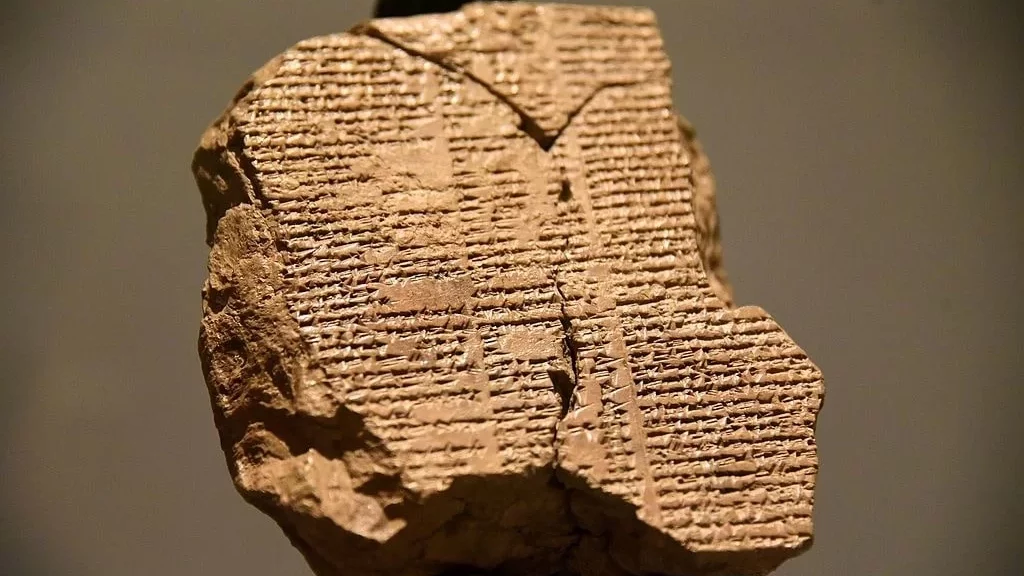
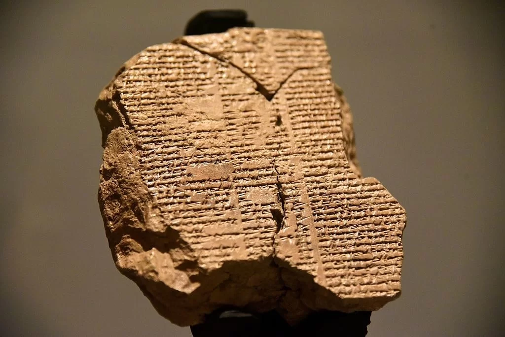
Furthermore, it matches up old text fragments, including pieces from the most recent tablet of the Epic of Gilgamesh which is considered the first work of literature in the world.
Professor Enrique Jimenez. Photo: Ludwig Maximilian University of Munich
This ancient Mesopotamian odyssey was written in the Akkadian language in 130 BC and tells the story of Gilgamesh, a ruler of the Mesopotamian city-state Uruk (Iraq).
According to the researchers, the oldest known version of the epic, which was written in cuneiform characters on clay tablets over 4,000 years ago, is “significantly younger” than this recently discovered version of the ancient Epic. It is very interesting, remarks Jiménez, that people were still copying Gilgamesh at this late period.
“There’s so much work to do in the study of Babylonian literature. The new texts we’re discovering are helping us understand the literature and culture of Babylon as a whole,” said Enrique Jiménez.
He plans to publish the Fragmentarium, along with a digital version of the Epic of Gilgamesh—the first containing all transcriptions of cuneiform fragments that are currently known—In February 2023.
“Everybody will be able to play around with the Fragmentarium. There are thousands of fragments that have not yet been identified,” says Jiménez.
Around 200 academics from around the world have used the online platform for their research projects since the project began.
Excavation of Anglo-Saxon Monastery Offers Clues to Viking Raids
Anglo-Saxon monasteries were more resilient to Viking attacks than previously thought, archaeologists have concluded. Lyminge, a monastery in Kent, was on the front line of long-running Viking hostility which ended in the victories of Alfred the Great.
The monastery endured repeated attacks, but resisted collapse for almost a century, through effective defensive strategies put in place by ecclesiastical and secular rulers of Kent, University of Reading archaeologists say.
The new evidence is presented after a detailed examination of archaeological and historical evidence by Dr Gabor Thomas, from the Department of Archaeology at the University of Reading.
“The image of ruthless Viking raiders slaughtering helpless monks and nuns is based on written records, but a re-examination of the evidence show the monasteries had more resilience than we might expect,” Dr Thomas said.
Despite being located in a region of Kent which bore the full brunt of Viking raids in the later 8th and early 9th centuries, the evidence suggests that the monastic community at Lyminge not only survived these attacks but recovered more completely than historians previously thought, Dr Thomas concludes in research, published today (30 January 2023) in the journal Archaeologia.
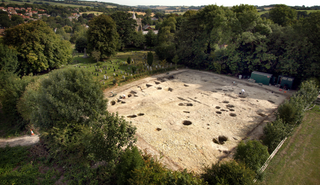
During archaeological excavations between 2007-15 and 2019, archaeologists uncovered the main elements of the monastery, including the stone chapel at its heart surrounded by a wide swathe of wooden buildings and other structures where the monastic brethren and their dependents lived out their daily lives. Radiocarbon dating of butchered animal bones discarded as rubbish indicates that this occupation persisted for nearly two centuries following the monastery’s establishment in the second half of the 7th century.
Historical records held at nearby Canterbury Cathedral show that after a raid in 804 CE, the monastic community at Lyminge was granted asylum within the relative safety of the walled refuge of Canterbury, a former Roman town and the administrative and ecclesiastical capital of Anglo-Saxon Kent.
But evidence from Dr Thomas’s dig shows the monks not only returned to re-establish their settlement at Lyminge, but continued living and building for several decades over the course of the 9th century. Dateable artefacts such as silver coins discovered at the site provided Dr Thomas with an insight into the re-establishment of the monastic community.
Dr Thomas said: “This research paints a more complex picture of the experience of monasteries during these troubled times, they were more resilient than the ‘sitting duck’ image portrayed in popular accounts of Viking raiding based on recorded historical events such as the iconic Viking raid on the island monastery of Lindisfarne in AD 793.
“However, the resilience of the monastery was subsequently stretched beyond breaking point.
“By the end of the 9th century, at a time when Anglo-Saxon king Alfred the Great was engaged in a widescale conflict with invading Viking armies, the site of the monastery appears to have been completely abandoned.
“This was most likely due to sustained long-term pressure from Viking armies who are known to have been active in south-eastern Kent in the 880s and 890s.
“Settled life was only eventually restored in Lyminge during the 10th century, but under the authority of the Archbishops of Canterbury who had acquired the lands formerly belonging to the monastery.”
The latest research article is based on the results of over a decade of archaeological research at Lyminge, directed by Dr Thomas. The village was first established by Anglo-Saxons in the 5th century.
Anomalies Detected in Walls Surrounding Ancient Capital in China
Muon scans are helping to find flaws and archeological surprises inside an ancient fortress wall in the Chinese city of Xi’an, which has grown and modernized since the wall was built nearly 650 years ago.
For nearly 650 years, the fortress walls in the Chinese city of Xi’an have served as a formidable barrier around the central city.
At 12 meters high and up to 18 meters thick, they are impervious to almost everything — except subatomic particles called muons.
Now, thanks to their penetrating abilities, muons may be key to ensuring that the walls that once protected the treasures of the first Ming Dynasty — and are now a national architectural treasure in their own right — stand for centuries more.
A refined detection method has provided the highest-resolution muon scans yet produced of any archaeological structure, researchers report in the Jan. 7 Journal of Applied Physics.
The scans revealed interior density fluctuations as small as a meter across inside one section of the Xi’an ramparts.
The fluctuations could be signs of dangerous flaws or “hidden structures archaeologically interesting for discovery and investigation,” says nuclear physicist Zhiyi Liu of Lanzhou University in China.
In this image, muons have revealed density anomalies in a section of the Xi’an fortress walls. All colors in this plot indicate places where densities are lower than average for the structure, with the bluer portions showing where density is lowest.
Muons are like electrons, only heavier. They rain down all over the planet, produced when charged particles called cosmic rays hit the atmosphere.
Although muons can travel deep into earth and stone, they are scattered or absorbed depending on the material they encounter. Counting the ones that pass through makes them useful for studying volcano interiors, scanning pyramids for hidden chambers and even searching for contraband stashed in containers impervious to X-rays (SN: 4/22/22).
Though muons stream down continuously, their numbers are small enough that the researchers had to deploy six detectors for a week at a time to collect enough data for 3-D scans of the rampart.
It’s now up to conservationists to determine how to address any density fluctuations that might indicate dangerous flaws, or historical surprises, inside the Xi’an walls.
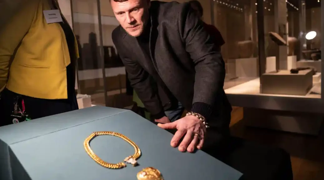
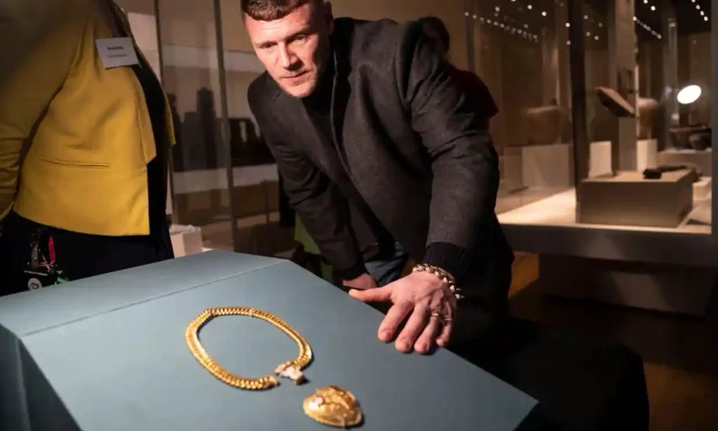
Charlie Clarke, pictured, says he will use the payment for the pendant and chain, now in the British Museum, to fund his son’s education.
Charlie Clarke had been metal detecting for just six months when he stumbled across what he calls his “once in a lifetime – no, once in 30 lifetimes”, find. He was exploring a Warwickshire field, turning up “junk” and about to call it a day, when a clear beep on his detector led him to dig to the depth of his elbow. What he saw there caused him to shriek “like a little schoolgirl, to be honest. My voice went pretty high-pitched”.
What the Birmingham cafe owner had discovered was a huge and quite spectacular early Tudor pendant and chain, made in gold and enamel and bearing the initials and symbols of Henry VIII and his first wife, Katherine of Aragon.
When Rachel King, curator of Renaissance Europe at the British Museum, first heard about the discovery, she had to sit down. Nothing of this size and importance from the Renaissance period had been found in Britain for more than 25 years, she said.
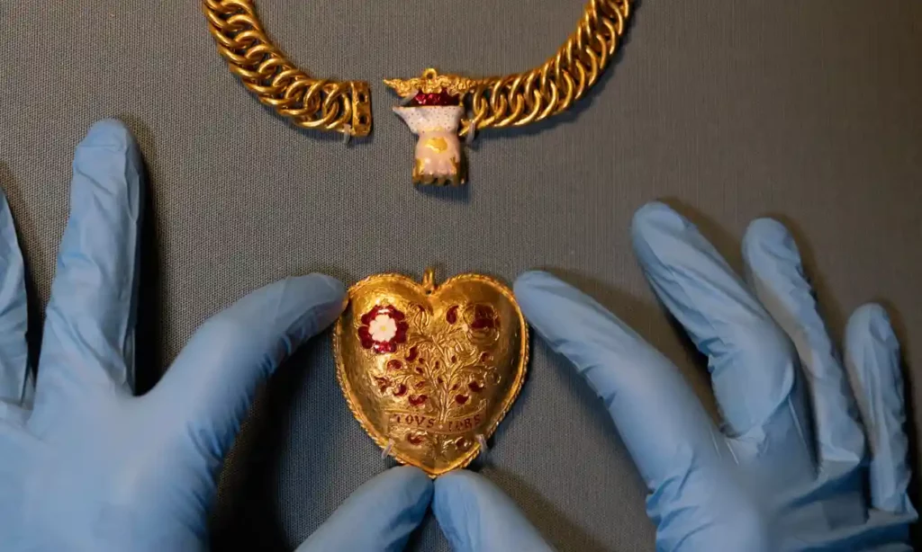
A Tudor chain associated with Henry VIII and Katherine of Aragon found in Warwickshire by Charlie Clarke while metal detecting.
The heart-shaped pendant, attached to a chain of 75 links and made of 300 grams of 24-carat gold, is decorated with a bush bearing the Tudor rose and a pomegranate, Katherine’s symbol, and on the reverse the initials H and K. Ribbon motifs carry the legend TOVS and IORS, which King called “a beautiful early English Franglais pun” on the French word “toujours” and “all yours”.
Despite initially seeming almost too good to be true, said King, careful scientific analysis has proved the pendant to be genuine. What experts have not been able to uncover, however, despite scouring inventories and pictures of the time, is to establish a personal link to Henry or Katherine.
“Nonetheless, its quality is such that it was certainly either commissioned by or somehow related to a member of the higher nobility or a high-ranking courtier.”
One hypothesis, based on careful analysis of its iconography and other historical records, is that the pendant may have been commissioned to be worn or even given as a prize at one of the major tournaments of which Henry was so fond, around the time of the famous Field of the Cloth of Gold in 1520. Though its size suggests it would only fit a woman, it may not have been meant to be worn at all.
Nothing remotely similar survives from the period, said King. “In the British Museum, we’ve got the largest collection of objects from the early Tudor periods in precious metal; none of them are anything like this.”
But what on earth was it doing in Warwickshire? On that, she said, they were still “feeling their way”. “We don’t know why it was in Warwickshire and who had it there. At least not yet.”
Discovered before the start of the pandemic, the pendant was unveiled at the launch of the annual reports of Treasure Act for 2020 and the Portable Antiquities Scheme for 2021.
A total of 45,581 archaeological finds were recorded in that period, of which 1,085 are classed as treasure – 96% were found by detectorists, most on cultivated land.
The Tudor pendant has not yet been valued but is certain to be worth a highly significant sum which Clarke will split with the landowner of the field. He said it meant his four-year-old son, also called Charlie, would have “the best education possible”. “That’s all it’s really about. Birmingham is a bit of a rough place, and I think any parent … would want the best education for their children.”
Inevitably, Charlie wants to be a treasure hunter when he is older, says his dad. “He wants to go to the jungle and find a box of pirate treasure. At that age, it must be so intriguing.
“People say it’s like winning the lottery; it’s not. People actually win the lottery. When was the last time a crown jewel was unearthed?”
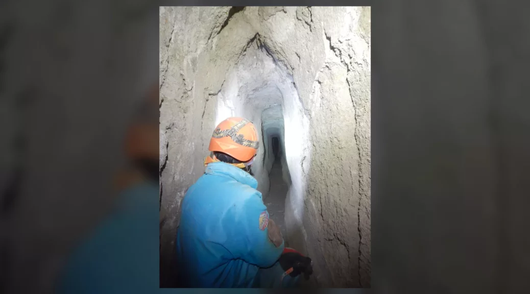
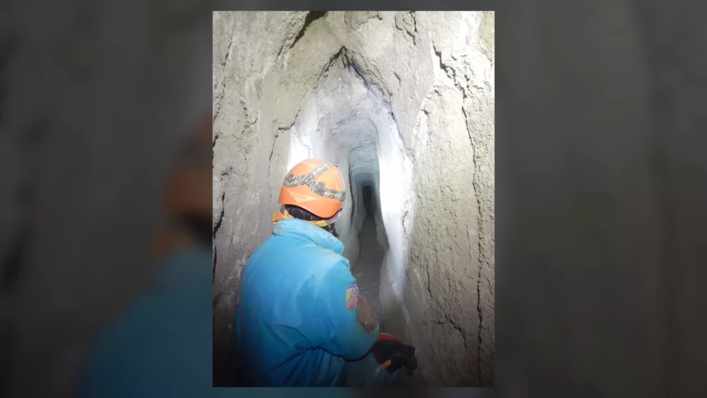
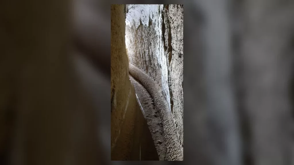
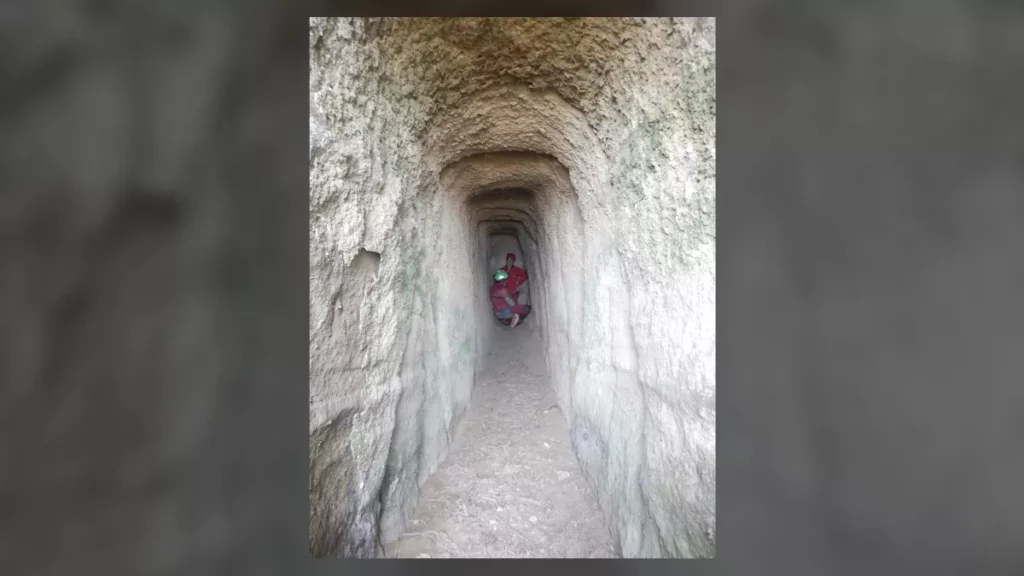
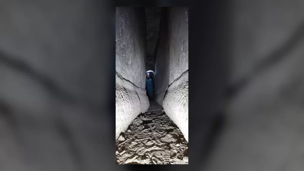
Speleologists explore the Aqua Augusta, a Roman aqueduct that was previously the least-documented aqueduct in the Roman world.
Forty years ago, when children in Naples were playing in caves and tunnels under the hill of Posillipo in Italy, they didn’t know their playground was actually a Roman aqueduct. When they shared their memories with archaeological authorities recently, it kicked off an exploration of one of the longest, most mysterious examples of ancient water infrastructure in the Roman world.
Rome’s famous aqueducts supplied water for baths, drinking, public fountains and more. Built during a period of about half a millennium (roughly 300 B.C. to A.D. 200), aqueducts around the former Roman Empire are highly recognizable today thanks to their multitiered arched structure. But this marvel of ancient architecture represents only a small fraction of the actual water system; the vast majority of the infrastructure is still underground.
Outside of Rome, subterranean aqueducts and their paths are much less understood. This knowledge gap included the newly investigated Aqua Augusta, also called the Serino aqueduct, which was built between 30 B.C. and 20 B.C. to connect luxury villas and suburban outposts in the Bay of Naples.
Circling Naples and running down to the ancient vacation destination of Pompeii, the Aqua Augusta is known to have covered at least 87 miles (140 kilometers), bringing water to people all along the coast as well as inland.
But the complex Aqua Augusta has barely been explored by researchers, making it the least-documented aqueduct in the Roman world. New discoveries earlier this month by the Cocceius Association, a nonprofit group that engages in speleo-archaeological work, are bringing this fascinating aqueduct to light.
This Roman aqueduct found in Naples supplied water to ancient luxury villas.
Local children used to play in this Roman aqueduct, but experts learned about it only recently.
Thanks to reports from locals who used to explore the tunnels as kids, association members found a branch of the aqueduct that carried drinking water to the hill of Posillipo and to the crescent-shaped island of Nisida. So far, around 2,100 feet (650 meters) of the excellently preserved aqueduct has been found, making it the longest known segment of the Aqua Augusta.
Graziano Ferrari, president of the Cocceius Association, told Live Science in an email that “the Augusta channel runs quite near to the surface, so the inner air is good, and strong breezes often run in the passages.” Exploring the aqueduct requires considerable caving experience, though.
Speleologists’ most difficult challenge in exploring the tunnel was to circumvent the tangle of thorns at one entrance.
“Luckily, the caving suits are quite thornproof,” he said. “After succeeding in entering the channel, we met normal caving challenges — some sections where you have to crawl on all fours or squeeze through.”
In a new report, Ferrari and Cocceius Association Vice President Raffaella Lamagna( list several scientific studies that can be done now that this stretch of aqueduct has been found. Specifically, they will be able to calculate the ancient water flow with high precision, to learn more about the eruptive sequences that formed the hill of Posillipo, and to study the mineral deposits on the walls of the aqueduct.
The present entrance of the aqueduct, with two people for scale.
Sinter (mineral deposits) building up on the side walls of the aqueduct, marking ancient water levels.
Rabun Taylor, a professor of classics at the University of Texas at Austin who was not involved in the report, told Live Science in an email that the newly discovered aqueduct section is interesting because it is “actually a byway that served elite Roman villas, not a city. Multiple demands on this single water source stretched it very thin, requiring careful maintenance and strict rationing.”
Taylor, an expert on Roman aqueducts, also said the new find “may be able to tell us a lot about the local climate over hundreds of years when the water was flowing.”
This insight is possible thanks to a thick deposit of lime, a calcium-rich mineral that “accumulates annually like tree rings and can be analyzed isotopically as a proxy for temperature and rainfall,” he explained.
Ferrari, Lamagna and other members of the Cocceius Association plan to analyze the construction of the aqueduct as well, to determine the methods used and the presence of water control structures.
“We believe that there are ample prospects for defining a research and exploration plan for this important discovery, which adds a significant element to the knowledge of the ancient population” living in the Bay of Naples, they wrote in the report.
A team of researchers affiliated with a host of institutions across Spain, working with one colleague from Portugal and another from Austria, has discovered a large number of animal skulls placed by Neanderthals in a Spanish cave more than 40,000 years ago.
In their paper published in the journal Nature Human Behavior, the group describes the site where the skulls were found, their condition and theories about why the skulls were placed in the cave.
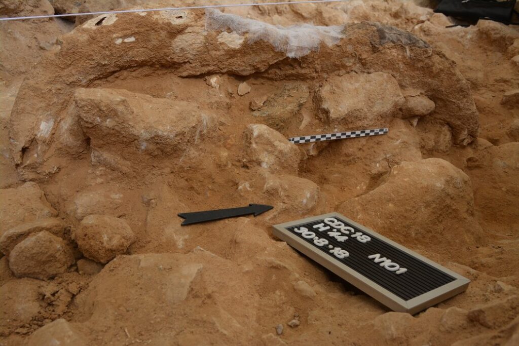
The Cueva Des-Cubierta cave located in the Madrid Region of Spain was first discovered in 1978. Since that time, archaeologists have visited and studied the multilevel cave because it became clear that Neanderthal groups used the site for conducting rituals.
Bones and tools have been found in the cave, as have the remains of a Neanderthal child. In this new study, the researchers climbed to the third level of the cave to see if Neanderthals had used it, as well.
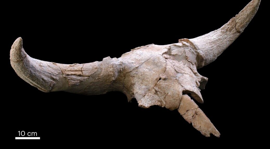
The researchers found multiple animal bones scattered on the floor in addition to an assortment of large herbivore skulls. The researchers found that the skulls had been carefully removed from the bodies and had been “worked” in different ways using tools and, in some cases, fire.
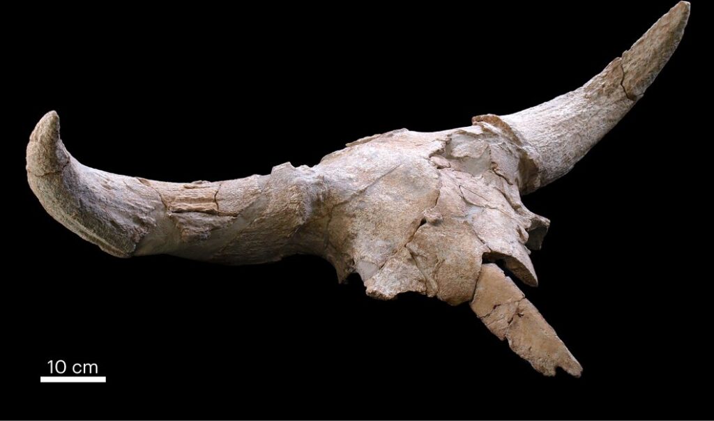
A common theme among the skulls was the display of prominent features, such as horns. Most of the skulls had once belonged to bison or aurochs, extinct cows. But they also found the skulls of five male deer (with antlers) and two rhinoceroses.
The discovery of the rhinoceroses was a major surprise, and the researchers chose to name one of them Rosendo, after the famous Spanish rock star.
Gneiss anvil under an aurochs cranium.
The team notes that finding such a collection of skulls suggests that the Neanderthal groups that brought them into the cave had something in mind besides food.
The skulls were large and heavy and would have provided little nourishment, suggesting their presence in the cave served some other purpose. The researchers suggest they may have represented hunting trophies.
Roman Intaglios Discovered in Bath Drain in England
Three of the semi-precious stones discovered by archaeologists near Hadrian’s Wall.
Taking your valuables with you into a swimming pool is always a risk. The Romans should have paid better heed, judging from the quantity of gemstones recovered from the drain of one of their bathhouses.
As many as 30 semi-precious stones have been discovered by archaeologists almost 2,000 years after their owners lost them at a site in modern-day Carlisle, just behind Hadrian’s Wall.
The stones had dropped out of their ring settings, their glue probably weakened in the steamy baths. They were simply flushed into the drains when the pools and saunas were cleaned.
Their loss would have been painful as these were engraved gems, known as intaglios. Although barely a few millimetres in diameter, they bear images whose extraordinary craftsmanship suggests they would have been expensive items in their day – the late 2nd century or 3rd century.
One bather lost an amethyst depicting Venus, holding either a flower or a mirror. Another lost a red-brown jasper featuring a satyr seated on rocks next to a sacred column.
Frank Giecco, an expert on Roman Britain who is leading the bathhouse excavation, was astonished by the collection: “It’s incredible,” he said. “It’s caught everyone’s imagination. They were just falling out of people’s rings who were using the baths. They were set with a vegetable glue and, in the hot and sweaty bathhouse, they fell out of the ring settings.”
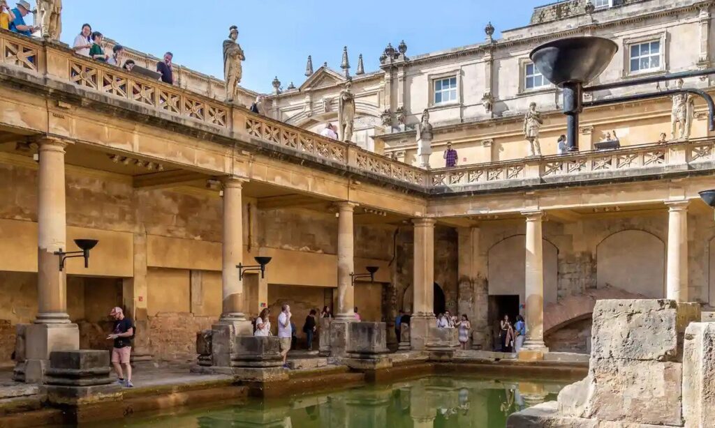
The Roman baths in Bath, where ‘curse tablets’ have been found.
He can imagine the Romans cursing after realising their loss. “They may not even have noticed until they got home because it’s the actual stone falling out of the rings – although we’ve also found one ring with a setting.”
Professor Martin Henig, an expert on Roman art at the University of Oxford, said: “Metal expands. If the stone is not properly secured, it can fall out, as it can today with people bathing. I imagine that the gems recovered from the drain were accumulated over time, and we must remember that a lot of people used those baths.”
Intaglios have previously been recovered from drains at York and at Caerleon near Newport. The Romans faced the dilemma we still face today of either losing their valuables in the water or to a sneak thief while they were bathing. This is reflected in several “curse tablets” found in Bath and elsewhere, which wished revenge on the perpetrators of such crimes.
One of those curses targets a ring thief: “So long as someone, whether slave or free, keeps silent or knows anything about it, he may be accursed in blood, and eyes and every limb and even have all intestines quite eaten away if he has stolen the ring.”
Henig said: “The difficulty is that you needed to take your ring off, but there were dangers. Where did you leave it? People must have been very upset when they lost a ring or the gem set in its bezel.”
The bathhouse was adjacent to the most important Roman fort on Hadrian’s Wall, the empire’s northern frontier, which held an elite cavalry unit and had links to the imperial court. Excavations will continue next year, but the evidence recovered so far – including imperial-stamped tiles – suggests that the bathhouse complex was monumental and opulent.
Giecco said: “You don’t find such gems on low-status Roman sites. So they’re not something that would have been worn by the poor.”
Beyond their decorative purposes, as rings worn by men and women, there was a symbolism within their imagery. The newly discovered intaglios include military themes, such as the god Mars holding a spear, and fertility, notably a charming image of a mouse nibbling a branch – Romans saw mice as symbols of rebirth or fertility.
Giecco said: “Some of the intaglios are minuscule, around 5mm ; 16mm is the largest intaglio. The craftsmanship to engrave such tiny things is incredible.”
The drain discoveries also include more than 40 women’s hairpins and 35 glass beads, probably from a necklace.
Mysterious Medieval City in Africa Had a Genius System to Survive Drought
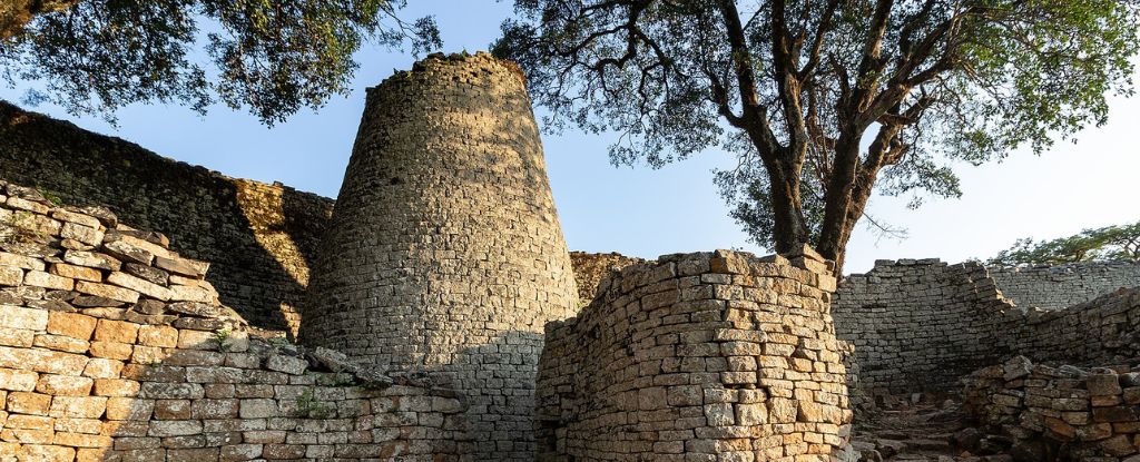
Great Zimbabwe.
Great Zimbabwe was the first major city in southern Africa, home to an estimated 18,000 people at its peak. Yet no one really knows why it now lies in ruins.
A team of researchers from Denmark, South Africa, England, and Zimbabwe argue that a series of large, circular depressions known as ‘dhaka’ pits, found around the city, were not used for digging up clay, as experts once thought, but for capturing water.
At the base of several hillsides, for instance, lie numerous dhaka pits, strategically placed to capture rain and groundwater. Other pits surrounding the city straddle streams.
By collecting rainwater and cordoning off some parts of a river or stream, researchers argue the people who once lived here could have ensured water was available for drinking and agriculture through most of the year, even in dry season.
Many of the plant remains found near dhakas, for instance, are known to thrive near rivers or groundwater sources that hold high soil moisture.
The new perspective of Great Zimbabwe’s dhaka pits was made possible by using airborne laser scanning to survey the major features of the site, even in places with thick vegetation.
These findings were then complemented by ground surveys and conversations with local communities, who must also conserve water in the arid region.
A map of the Great Zimbabwe ruins showing the main structures.
Figuring out how much water all the dhakas around the city could have once held is imprecise work, especially since this is one of the first studies to really examine the structures. Nevertheless, estimates suggest these pits might have stored over 18 million liters of water.
In the heyday of Great Zimbabwe, between the 11th and 15th centuries, the city was home to ruling elites, religious leaders, craftsmen, and merchants, all of whom would have shared spring water and rainwater in an integrated and flexible system.
During the rainy season, experts say some areas of the city would have become wet and marshy. These locations appear to have been perfect for mining clay to build houses. In drier times, some of these quarries seem to have been turned into reservoirs to collect groundwater and runoff from surrounding hills.
“This partially engineered landscape required maintenance, though organized in a relatively passive manner as runoff was allowed to wash into these basins,” the authors write.
“Taken together, the new records show that physical forms, ecological functions, and cultural values of water all shaped, and were shaped by, how communities approached, managed, and conserved water,” they add.
Today, very little is known about the history of Great Zimbabwe. It’s still possible that the city collapsed due to climate change, even with such a carefully coordinated water system.
During its existence, the world experienced the Medieval Climatic Anomaly and a Little Ice Age, which could have put the growing city under immense stress. But economic or political strains could have also caused its demise.
More research needs to be done before archaeologists can say what happened to southern Africa’s first city and its people. Perhaps there’s a lesson to be learned in the ruins.