Oopart (out of place artefact) is a term applied to dozens of prehistoric objects found in various places around the world that seem to show a level of technological advancement incongruous with the times in which they were made.
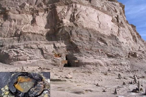
Ooparts often frustrate conventional scientists, delight adventurous investigators open to alternative theories, and spark debate. In a mysterious pyramid in China’s Qinghai Province near Mount Baigong are three caves filled with pipes leading to a nearby salt-water lake. There are also pipes under the lake bed and on the shore.
The iron pipes range in size, with some smaller than a toothpick. The strangest part is that they may be about 150,000 years old.
Dating done by the Beijing Institute of Geology determined these iron pipes were smelted about 150,000 years ago, if they were indeed made by humans, according to Brian Dunning of Skeptoid.com.
And if they were made by humans, history, as it is commonly viewed, would have to be re-evaluated.
The dating was done using thermoluminescence, a technique that determines how long ago crystalline mineral was exposed to sunlight or heated. Humans are only thought to have inhabited the region for the past 30,000 years.
Even within the known history of the area, the only humans to inhabit the region were nomads whose lifestyle would not leave any such structures behind.
The state-run news agency Xinhua in China reported on the pyramid, the pipes, and the research began by a team of scientists sent to investigate in 2002.
Though some have since tried to explain the pipes as a natural phenomenon, Yang Ji, a research fellow at the Chinese Academy of Social Sciences, told Xinhua the pyramid may have been built by intelligent beings.
He did not dismiss the theory that ancient extraterrestrials may be responsible, saying this theory is:
“understandable and worth looking into… but scientific means must be employed to prove whether or not it is true.”
Another theory is that it was built by prehistoric humans with techniques lost to humans of a later period.
The pipes lead into a salty lake, though a twin lake nearby contains freshwater. The surrounding landscape is strewn with what Xinhua described as “strangely shaped stones.” Rocks protrude from the ground like broken pillars.
The head of the publicity department at the local Delingha government told Xinhua the pipes were analyzed at a local smeltery and 8 per cent of the material could not be identified. The rest was made up of ferric oxide, silicon dioxide, and calcium oxide.
The silicon dioxide and calcium oxide are products of long interaction between the iron and surrounding sandstone, showing the ancient age of the pipes. Liu Shaolin, the engineer who did the analysis, told Xinhua:
“This result has made the site even more mysterious. Nature is harsh here,” he said. “There are no residents let alone modern industry in the area, only a few migrant herdsmen to the north of the mountain.”
To further add to the mystery, Zheng Jiandong, a geology research fellow from the China Earthquake Administration told the state-run newspaper People’s Daily in 2007 that some of the pipes were found to be highly radioactive.
Other Theories
Jiandong said iron-rich magma may have risen from deep in the Earth, bringing the iron into fissures where it would solidify into tubes. Though he admitted,
“There is indeed something mysterious about these pipes.”
He cited radioactivity as an example of the strange qualities of the pipes. Others have said iron sediments may have washed into the fissures, carried with water during floods.
Though Xinhua and other publications in China have referred to a pyramid or even a mysterious pyramid in which the pipes were found, some have said it was a pyramid-shaped natural formation. Another theory is that the pipes are fossilized tree roots. Xinmin Weekly reported in 2003 that scientists found plant matter in an analysis of the pipes, and they also found what looked like tree rings.
The article related the finding to a geological theory that in certain temperatures and under certain chemical conditions, tree roots can undergo diagenesis (transformation of soil into rock) and other processes that can produce iron formations.
Reports on the tree-root explanation for the so-called Baigong pipes often lead back to this Xinmin Weekly article or lack citation. It’s unclear exactly how well-supported this theory is in relation to the Baigong pipes.
An article published in the Journal of Sedimentary Research in 1993 describes fossilized tree roots in South Louisiana in the United States.
Hollow Earth: The Forbidden Land Of Agartha And The Thule Secret Society
In 1943, German Navy Grand Admiral Karl Doenitz stated that the German submarine fleet had “built for the Führer an impregnable fortress at the other end of the world,” in the region of Queen Maude’s Land, Antarctica, later renamed Neuschwabenland. According to German naval archives, two months after Germany surrendered to the Allies in April 1945, the German submarine U-530 left the Port of Kiel bound for Antarctica.
Once the submarine arrived at the South Pole, 16 members of its crew were ordered to construct an ice cave in the region of Neuschwabenland. The German U-boat then entered the Argentinean port of Mar-del-Plata and surrendered to authorities.
In August 1945, one month and seven days after the surrender of U-530, U-977 also entered the waters of Mar-del-Plata and surrendered to authorities.
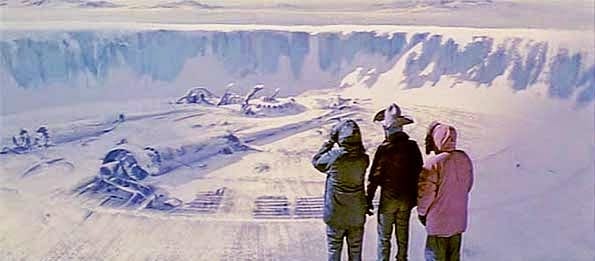
In 1946, Operation Highjump commenced as part of the U.S. Naval Antarctic Developments Project, organized by Secretary of the Navy James Forrestal. The task force consisted of over 40 ships, including two destroyer class vessels and the aircraft carrier the U.S.S. Philippine Sea, and a number of planes that were outfitted with a trimetricon (a secret spying camera), a magnetometer (to record any magnetic anomalies), and the recently developed jet-assist takeoff bottles (JATO) which helped with takeoffs from the short runway on an aircraft carrier or for takeoffs on hard ice. It has been long thought by researchers that the Navy’s mapping story was nothing more than a cover to shield the real operation. They were looking for the underground Nazi base (Base-211) that warehoused German Vril flying discs known as flugscheiben and Thule mercury-powered spaceship prototypes also known as jenseitsflugmaschines.
In 1947, Admiral Richard Byrd said:
“The project was necessary for the USA to take defensive actions against enemy fighters which come from the polar regions.”
Was he referring to potential Soviet aircraft or Nazi Luftwaffe attacking the States from Antarctica? He never clarified. Shortly after Admiral Byrd’s press conference the Soviet naval journal, Red Fleet, stated that:
“US measures in Antarctica testify that American military circles are seeking to subject the Polar Regions to control and create permanent bases for their armed forces.”
In another odd twist, the governments of New Zealand, Australia and Chile asked for their militaries to join the Operation Highjump expedition but were denied participation. In 1948, a second task force named Operation Windmill was also sent to take photographs of Neuschwabenland, again supposedly for mapping purposes. Although they apparently succeeded in their task, the government has yet to make these photos available to the public and no reason has ever been given for their nondisclosure.
Some believe that the reason the photos have never been released is that this military operation was actually a reconnaissance and recovery mission. In 1949 Secretary of Defense James Forrestal, a close friend of Admiral Byrd, was sent to stay at Bethesda Naval Hospital. He began to discuss Operation Highjump with the hospital staff, talking wildly about UFOs, Atlantis, and an underground Nazi city. He was denied visitors, including his wife, and shortly afterwards “fell” out of his hospital window to his death.
Actual pictures of Vril flying saucers
The official report said that he committed suicide but persistent rumours say that he was murdered by government agents to keep him from talking further about what was really found in the Antarctica wilderness during Operation Highjump. The entire truth of the matter may never come to light, but what is known is that numerous U.S. military personnel surprisingly lost their lives during Operation Highjump; a supposed mapping operation that should have been an entirely safe endeavour. Also, multiple planes were downed during the operation, including the George One which, according to Naval documents, mysteriously “just blew up” over the ice during its initial flight in Antarctica. According to British Intelligence, we know that advanced, stealth foo fighters and Vril flying saucer-shaped craft were developed and tested at the German Institute for Aerial Development.
Another motive associated with Nazi involvement in Antarctica is that it was rumoured to be the entrance to the lost Aryan homeland of Thule. While Antarctica has been linked to the lost continent of Atlantis, the linkage to Thule is less apparent. Thule (also known as Thula, Thyle, Thila, Tila, Tyle, or Tylen, among other cognates) was first written about by the Greek explorer Pytheas after his travels between 330 BC and 320 BC. In 150 AD, Greek writer Antonius Diogenes wrote The Wonders Beyond Thule. While of literary interest, this work did little to reveal any secrets about Thule. In medieval geographies, Thule was referred to an as a distant place located beyond the “borders of the known world.” Occult mystics believe in historical Thule (also referred to as Hyperborea) as the ancient origin of the Aryan race.
Just what was the US military doing in Antarctica in 1946 and 1947? Were they on a routine mapping mission or were they engaging remnant Nazi fighters with advanced alternative technology?
Did the Nazis truly build a military base in the Antarctic or hide vast amounts of gold there in hopes of funding a future effort to resurrect the Fourth Reich? Or did they, as some claim, discover the lost land of Atlantis or Thule?
We may never know for sure, but in 2001 the U.S. National Geospatial-Intelligence Agency and the Support Office for Aero-geophysical Research confirmed the existence of a magnetic anomaly on the eastside shore of Lake Vostok in Antarctica, consistent with a man-made construct. More recently, in October 2006, the Scripps Institute of Oceanography reported that they discovered several previously unknown lakes of water underneath the vast ice sheet of Antarctica. These lakes lie beneath 2,300 feet of compressed snow and ice. Could this anomaly be part of an underground Nazi base that U.S. agents searched for during Operation Highjump? Something has indeed been discovered in Antarctica. One of the questions that begs to be asked is did the Nazis find, whatever it is, first?
A book published in 1978, called Secret Nazi Polar Expeditions, relates how the Germans had taken a ship with a small airplane on it that they launched from their ship after reaching the ice near Antarctica.
It flew over the ice to Antarctica, presumably on a scouting flight, and then back to the ship. But the book didn’t say anything about what it supposedly found or what the Nazi party elite believed was an entrance to the inner (hollow) earth.
An interesting document has recently surfaced obtained by a Joe Watson of Talkeetna, Alaska.
Mr. Watson claims it is a copy of a letter written on 2 March 1985 in the German language from a German submarine crewman who was on board. In it is given certain coordinates for their mission, which apparently was to travel to the center of the earth. Their submarine was called U-209 under Captain Heinrich Brodda. The image below is a copy of the original hand-written letter from Karl Unger, crew member of the German U-209, as well as an English translation (click to enlarge).
In it, Karl confirmed that the earth was indeed hollow and that they had successfully reached the inner inhabited earth in the German U-209 submarine after World War II had destroyed Germany.
The letter was sent to his friend here on the surface world who gave a copy of it to a Mr. Woodard, who gave a copy to Joe Watson. Karl had sent the letter from the hollow earth through a German colony in Brazil that had found a cavern that reaches to the hollow earth many years previous. This German colony in Brazil is documented in Genesis For a New Age, having supposedly discovered the cavern entrance back in the 1500’s. When one does a search at the German archive website looking for information on the missing U-209 German submarine, it shows that the submarine was indeed reported missing.
On July 5, 1943 was it’s last reported position between Greenland and Iceland at coordinates 52°00’N-38°00’W. The report said the Commander of the submarine was Heinrich Brodda.
In addition, documents obtained by the soviets at the close of WW2 recently surfaced which shows a 1944 map from the Third Reich detailing not only the direct passageway used by German U-boats to access this subterranean domain, but also a complete map of both hemispheres of the inner realm of Agharta, the mythical name of the inhabited subterranean world.
If that seems too unbelievable, compare with those maps, this map done by the famed Tyrolean cartographer and artist Heinrich C. Berann for the National Geographic Society beginning in 1966.
The following map clearly shows the continent of Antarctica without its cover of ice:
The intriguing detail here is that there are underwater passageways that run nearly the entire length of the continent and seem to converge at the exact location identified as the opening into the deep inner or subterranean earth.
Below is a translation of the Top Secret instructions and specific detailed directions left for the Nazi U-boat Captains to follow in order to reach the inner-world kingdom of Agartha.
In his groundbreaking bestseller Map of the Ancient Sea Kings, Charles Hapgood (1904-1982), History Professor at Springfield College in Springfield, Massachusetts, first put forth the theory that Atlantis resided in Antarctica and was destroyed by crustal displacement.
In his bestseller, When The Sky Fell: In Search of Atlantis, Rand furthered the idea that under the ice of Antarctica exists the remains of Atlantis. Could they be right?
Beaver fur was a symbol of wealth and an important trade item in 10th Century Denmark, according to a study published July 27, 2022, in the open-access journal PLOS ONE by Luise Ørsted Brandt of the University of Copenhagen and colleagues.
Written sources indicate that fur was a key commodity during the Viking Age, between 800-1050 CE, but fur doesn’t often survive well in the archaeological record, so little direct evidence is available.
Previous reports have used the microscopic anatomy of ancient fur to identify species of origin, but this method is often inexact. All in all, not much is known about the kinds of furs the Vikings preferred.
Map of studied sites (a) and examples of included fur: b) Hvilehøj C4273-97, fragment 1, c) Hvilehøj C4280c, d) Bjerringhøj C143. Graphics: Luise Ørsted Brandt and Charlotte Rimstad.
In this study, Brandt and colleagues analyzed animal remains from six high-status graves from 10th Century Denmark.
While no ancient DNA was recovered from the samples, perhaps due to treatment processes performed on furs and skins and probably due to preservation conditions, identifiable proteins were recovered by two different analytical techniques.
Grave furnishings and accessories included skins from domestic animals, while clothing exhibited furs from wild animals, specifically a weasel, a squirrel, and beavers.
These findings support the idea that fur was a symbol of wealth during the Viking Age.
The fact that beavers are not native to Denmark suggests this fur was a luxury item acquired through trade.
Some clothing items included fur from multiple species, demonstrating a knowledge of the varying functions of different animal hides, and may have indicated a desire to show off exclusive furs.
The authors note the biggest limiting factor in this sort of study is the incompleteness of comparative protein databases; as these databases expand, more specific identifications of ancient animal skins and furs will be possible.
The authors add: “In the Viking Age, wearing exotic fur was almost certainly an obvious visual statement of affluence and social status, similar to high-end fashion in today’s world.
This study uses ancient proteins preserved in elite Danish Viking burials to provide direct evidence of beaver fur trade and use.”
Neolithic Tomb Linked to King Arthur Investigated in England
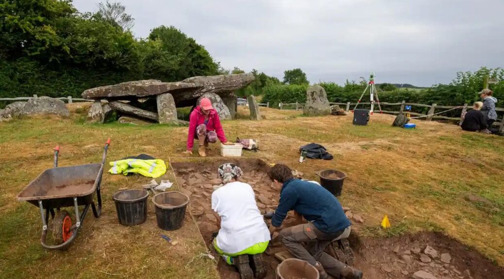
High above one of western Britain’s loveliest valleys, the silence is broken by the sound of gentle digging, scraping and brushing, along with bursts of excited chatter as another ancient feature is revealed or a curious visitor stops by to find out what is going on.
Archaeologists digging at Arthur’s Stone, Herefordshire, thought it to be an important neolithic meeting place like Stonehenge and Avebury.
This summer archaeologists have been granted rare permission to excavate part of the Arthur’s Stone site, a neolithic burial plot with soaring views across the Golden Valley in Herefordshire and the Black Mountains of south-east Wales.
Using their version of keyhole surgery, the archaeologists unearthed features, including what appear to be stone steps leading up to the 5,000-year-old tomb, and tools used by the first people to farm this landscape.
The 25-strong team have launched drones that have pinpointed possible sites of several other ancient burial spots nearby, all of which are leading them to surmise that Arthur’s Stone – like the circles at Stonehenge and Avebury – was an important meeting place and possibly part of a much larger complex of inter-related monuments.
Julian Thomas of Manchester University at the dig site.
“Arthur’s Stone is one of the most wonderful ancient monuments in the care of the nation but it’s been very poorly understood,” said Julian Thomas, a professor of archaeology at the University of Manchester, who is leading the dig. “We’re trying to do justice to it, put it in the context of what was happening in the very early neolithic.”
Over the centuries the site has inspired storytellers as well as archaeologists and historians. King Arthur was said to have killed a giant on the spot; indentations on the surface of the tomb’s capstone were supposedly made by the creature’s elbows as it fell backwards.
In the 20th century, CS Lewis is said to have used the monument as the inspiration for the stone table on which Aslan is sacrificed in The Lion, the Witch and the Wardrobe.
Thomas said the true story emerging was of a monument developed over many decades or centuries in the very early neolithic period by the first farmers and last hunter-gatherers.
He said it was becoming clear that it was almost certainly connected to two other nearby sites, Dorstone Hill, where prehistoric halls were burned and incorporated into burial mounds, and a long barrow at Cross Lodge.
The site has views across the Golden Valley in Herefordshire and the Black Mountains of southeast Wales.
The site also seems oriented towards a mountain on the horizon across the border in Wales called the Skirrid, another place steeped in myth and legend, where a landslide was said to have been caused by an earthquake or lightning strike at the moment of the crucifixion of Jesus Christ.
Keith Ray, an honorary professor of archaeology at Cardiff University, who is also overseeing the digging, said he had been asking people to look afresh at the Skirrid and imagine what it may have meant to ancient people. “I’ve thrown out one idea, it’s a bit wacky, but could it have looked like a mammoth to them and reminded them of this giant creature that used to roam here.”
Visitors have flocked to the dig from near and far. Ben Hughes, a musician based in Cardiff, said he found the site “strange, weird, wonderful, fascinating”. He said: “For me it feels like an in-between sort of place, with the more gentle landscape behind and the mountains over there. I can see why people have met here for centuries.”
Pam Thom-Rowe, an English Heritage volunteer guide, said visitors from as far away as Texas had been on site. “To me it feels like the monument is putting feelers out on the landscape.”
Thomas examines uncovered stones, and evidence of a wall around the site.
Such is the excitement at what is being found – and the public response – that the chief executive of English Heritage, Kate Mavor, is paying a visit on Friday. She said new archaeology and research continued to find fresh stories.
“Exploring a site like Arthur’s Stone is a fascinating process and something we wanted to open up to the public,” she said. “We’ve had a great response.”
Keeping an eye on the dig was Win Scutt, a properties curator at English Heritage. He said it was rare for permission to be given for this type of exploration within a scheduled monument. “This is very delicate, targeted keyhole sampling to try to answer specific questions,” he said.
Scutt said ideas about what the site was all about had changed immensely over the past few weeks – making the details on the English Heritage interpretation board out of date. “But I won’t be in too much of a rush to change it. The story will be different next year and the year after that. Which is the very exciting thing.”
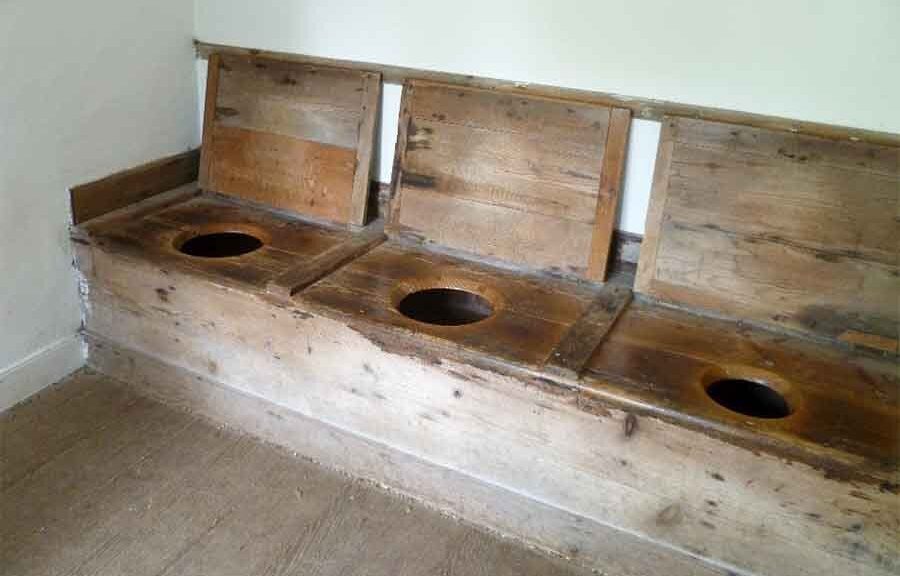
Helle’s Toilet: Three-Person Loo Seat was Unusual Medieval Status Symbol
A rare 12th-century toilet seat built to accommodate three users at once is to go on display for the first time at the Museum of London Docklands.
Conservator Luisa Duarte working on the 12th-century toilet seat.
Nine hundred years after the roughly carved plank of oak was first placed over a cesspit near a tributary of the Thames, it will form the centrepiece of an exhibition about the capital’s “secret” rivers.
The strikingly well-preserved seat, still showing the axe marks where its three rough holes were cut, once sat behind a mixed commercial and residential tenement building on what is now Ludgate Hill, near St Paul’s Cathedral, on land that in the mid-1100s would have been a small island in the river Fleet.
Remarkably, archaeologists have even been able to identify the owners of the building, which was known at the time as Helle: a capmaker called John de Flete and his wife, Cassandra.
“So what I love about this is that we know the names of the people whose bottoms probably sat on it,” said Kate Sumnall, the curator of archaeology for the exhibition.
Axe marks are visible where the seat’s three rough holes were cut.
They would probably have shared the facilities with shopkeepers and potentially other families who lived and worked in the modest tenement block, she said. “This is a really rare survival. We don’t have many of these in existence at all.”
Around 50 small rivers and tributaries of the Thames are known, according to Sumnall, many of which, including the Fleet, Westbourne, Effra and Tyburn, have now been routed underground. But their influence on the topography of London has been significant, and their banks, bends and islands can still be identified in the capital’s slopes and bumps. “No one perfectly flattens the land before building the next stage,” she said.
Among the other artefacts going on display is a late bronze age sword dating from 1000BC, two Viking battleaxes and a 14th-century iron sword found in Putney, all of which appear barely corroded despite having spent centuries buried in mud.
Also on display will be a late 18th-century copper alloy dog collar, inscribed to “Tom, of the Gray Hound, Bucklers Bury” – a street close to what is now Bank – which was also excavated from the Fleet.
“We are very lucky in London that we tend to get really great preservation of a lot of things from the river,” said Luisa Duarte, the archaeological conservator.
Thanks to the low-oxygen environments of the waters and surrounding muds, she said, “in the case of the metals we have very low corrosion, and in organics, we have a very low biological activity. That’s why in London we have so much wood and leather – sometimes we have more organic Roman material than in Rome.”
The toilet seat was first excavated in the 1980s as part of what was, at the time, the largest archaeological dig in London. But because the money ran out, the findings were never published, which is why the seat has never gone on display before now.
The museum has commissioned a replica, which will form part of the exhibition and which visitors will be invited to try.
Sumnall said it was quite comfortable, but were three people to use at once “I imagine you would be touching shoulders, which would be slightly awkward.”
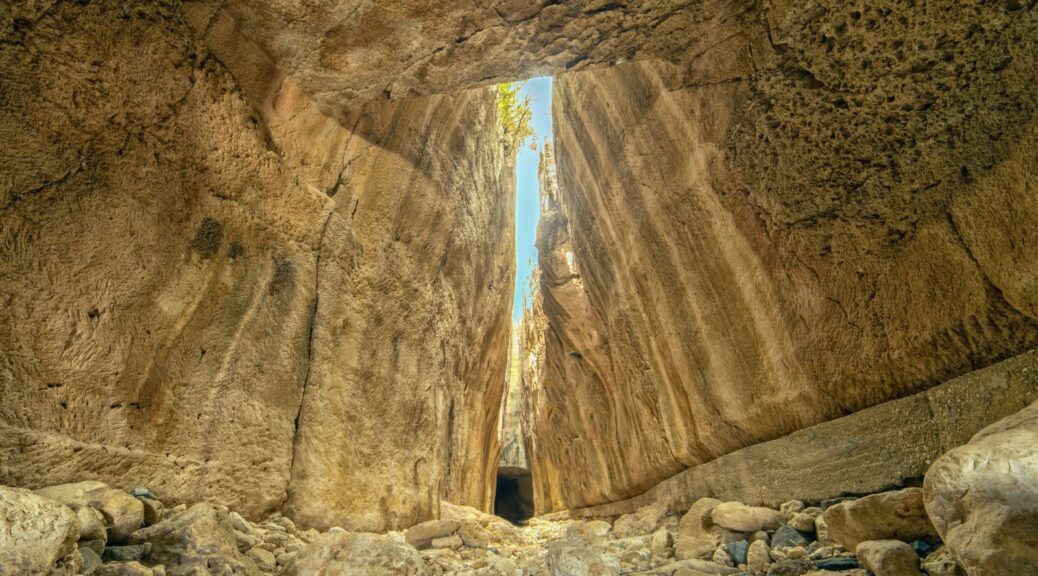
The ancient Roman Titus Tunnel, in the Samandağ district of Hatay, Turkey.
In the Samandağ district of southern Turkey’s Hatay province, the Vespasianus Titus Tunnel, or simply the Titus Tunnel, is a magnificent ancient structure constructed by 1,000 slaves to prevent floodwaters in the area, has been garnering particular attention from tourists.
The Titus Tunnel was a mega project 2,000 years ago carved into the mountain, and it still stands as an unbelievable engineering marvel.
The tunnel, which was built to prevent floodwaters that carried sand and gravel down the mountains from filling the city’s harbour and threatening it, was first conceived by the Roman Emperor Vespasian, who started its construction in A.D. 69. Its construction continued during the reign of his successor and son Emperor Titus and in the times of his other successors.
The ancient Roman Titus Tunnel, in the Samandağ district of Hatay, Turkey.
It was finally completed during the era of Antoninus Pius in the second century. It was built by digging the rocks using human resources only.
The tunnel is part of a water diversion system consisting of a dam, a short approach channel, the first tunnel section, a short intermediary channel, the second tunnel section and a long discharge channel.
It hosts an inscription elegantly carved into the rock at the first tunnel entrance that reads the names of Vespasianus and Titus, while there is another one at the discharge tunnel for Antonious.
Ancient structures near the Roman Titus Tunnel, in the Samandağ district of Hatay, Turkey.
It stands today as a must-see site for anyone that visits Hatay as it takes visitors on a wonderful journey through time. The tunnel is 1,380 meters (4,527 feet) long with a height of 7 meters and a width of 6 meters, attracting admiration from local visitors and abroad with its architecture in the middle of nature.
The tunnel is part of a water diversion system consisting of a dam, a short approach channel, the first tunnel section, a short intermediary channel, the second tunnel section and a long discharge channel.
It is located at the foot of the Nur Mountains, near the modern village of Çevlik, 7 kilometres (4.3 miles), northwest of central Samandağ (the medieval port of Saint Symeon) and 35 kilometres southwest of Antakya.
The ancient Roman Titus Tunnel, in the Samandağ district of Hatay, Turkey.
Beşikli Cave where 12 rock tombs are located near the ancient Roman Titus Tunnel, in the Samandağ district of Hatay, Turkey.
Beşikli Cave is also right next to the tunnel, standing only 100 meters away, boasting a particularly flashy architectural structure and decoration. In the cave, there are tombs from the ancient Roman period, believed to belong to a nobleman and his family.
Those who come to visit the tunnel also get the chance to see the tomb chambers here.
Ayşe Ersoy, director of the Hatay Archaeology Museum, said that it was evident from these sites as well that Hatay occupied a significantly important historical and cultural value.
Ersoy stated that the city had hosted several civilizations throughout its history and that now it was receiving great interest from both domestic and foreign visitors. She noted that the Titus Tunnel was one of the most remarkable places in the city.
She also said that the number of visitors to the tunnel was increasing day by day.
Beşikli Cave where 12 rock tombs are located near the ancient Roman Titus Tunnel, in the Samandağ district of Hatay, Turkey.
The path between high stone walls to the ancient Roman Titus Tunnel, in the Samandağ district of Hatay, Turkey.
“The 1,380-meter-long Titus Tunnel, an important Roman ruin of our city, takes its visitors on a journey in time,” Ersoy said and added, “More than 28,000 local and foreign visitors have been to Titus Tunnel over the last eight months in Samandağ.”
Cafer Tayyar Demirci, who came from Gaziantep, said, “Titus Tunnel is a place of a natural wonder; everyone should definitely stop by here.”
Celal Karadavut, who came from Mersin to visit the tunnel with his family, said that Hatay is an important city that has left its mark on history.
Karadavut stated that he was pleased to visit the city that has hosted many civilizations. “Hatay is a city that has a different place in Turkey both in terms of history, nature and gastronomy,” he said.
Şükran Naz Karadavut also noted that she liked the tunnel very much and that everyone should see it.
Archaeologists unearth a 3,500-year-old warrior’s grave in Greece
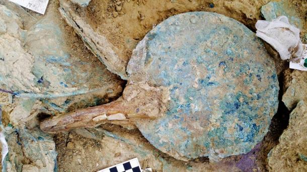
An undated picture released on October 26, 2105, by the Greek Culture Ministry shows an ivory comb, one of the items found in a 3,500 years old warrior tomb unearthed in the Peloponnese region of Greece
Archaeologists in Greece have made a rare and exciting discovery – an ancient unlooted tomb with the remains of an unknown warrior and a huge hoard of treasure. The Greek Ministry of Culture announced that it is the most important treasure to have been discovered in 65 years.
The Ministry of Culture announced the finding today, revealing that two US archaeologists, Jack L. Davis and Sharon R. Stocker from the University of Cincinnati, made the discovery while excavating the 3,500-year-old Palace of Nestor on Greece’s Peloponnese peninsula.
The Palace of Nestor, located at the top of the hill of Epano Englianos, near Pylos, is the best preserved Mycenaean Greek palace discovered. It once consisted of a two-storey building with reception rooms, baths, workshops, store rooms, and an established sewage system.
Photo of Nestor’s Palace taken in 2010.
The tomb, which measures 2.4 meters in length and 1.5 meters in width, was discovered on the site of the palace complex.
However, it had been placed there many years before the palace was built. Surprisingly, the tomb had not been looted in antiquity, unlike most of the other Mycenaean-era tombs found to date.
Inside the tomb, archaeologists discovered the remains of a wooden coffin containing the skeleton of an unknown warrior, aged between 30 and 35 years old.
Next to him were his weapons – a bronze sword with a gold and ivory handle and a gold-hilted dagger.
Considering his place of burial and the treasures he was buried with, he is believed to have been a person of great importance.
According to the Ministry of Culture, the treasures also included gold rings, an ornate string of pearls, 50 Minoan seal stones carved with imagery of goddesses, silver vases, gold cups, a bronze mirror, ivory combs, an ivory plaque carved with a griffin, and Minoan-style gold jewellery decorated with figures of deities, animals, and floral motifs.
A bronze mirror with an ivory handle was found in the grave of the warrior.
Many of the artefacts found in the tomb have been traced to Crete, the island upon which the Minoan civilization arose.
James C. Wright, the director of the American School of Classical Studies at Athens, told the New York Times that the finding of the tomb “will help scholars understand how the state cultures that developed in Crete were adopted into what became the Mycenaean palace culture on the mainland.”
Artefacts were recovered from the grave of the ancient warrior.
Archaeologists now plan to carry out a DNA analysis on the warrior’s remains to try to determine his origin. They also plan to carry out radiocarbon tests on the plant material recovered from the tomb, which may allow more accurate dating of the burial.
Evidence of Third-Century A.D. Tsunami Uncovered in Spain
The Seville Cathedral, as seen from Patio de Banderas Plaza.
In the 1970s, two Roman inscriptions — dated from 245 to 253 AD — were discovered in Écija (known in ancient Roman times as Astigi), a city in Spain’s southern province of Seville. The writings on the tablets suggest that the emperor at the time had exempted the Roman province of Baetica (roughly the equivalent of modern-day Andalusia, a region of southern Spain) from taxes. But the inscriptions failed to explain why, and the reason has remained a mystery for decades.
In a new study published in Natural Science in Archaeology, a team of European and U.S. scientists and researchers say they have finally found an explanation. The article, A Third Century AD Extreme Wave Event Identified in a Collapse Facies of a Public Building in the Roman City of Hispalis (Seville, Spain), provides a surprising answer: A gigantic tsunami that began in the Bay of Cadiz crashed into the land, causing numerous coastal settlements to be abandoned and engulfing everything its path, including the city of Seville, located 45 miles inland from the sea.
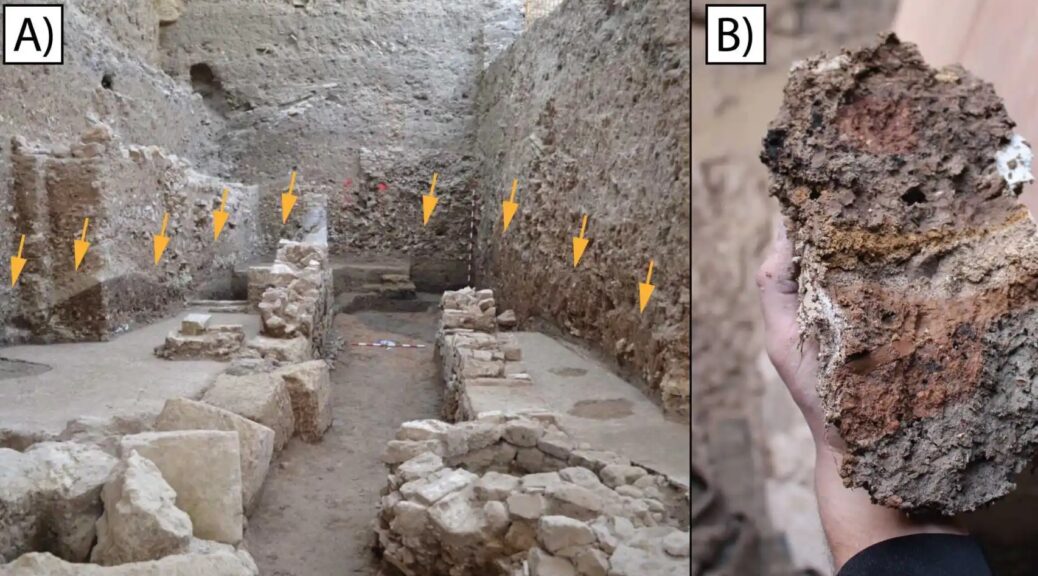
The discovery was made following the excavation and study of a public building from the Roman era, destroyed during what researchers now believe was a massive tidal wave event. The building once stood in what is now the Patio de Banderas public square in Seville, adjacent to the capital city’s main cathedral.
The report, authored by experts from universities in Spain, France, Germany, and the U.S. describes how, in 400 BC, the Atlantic Ocean had created a large lagoon, known in antiquity as Lacus Ligustinus, at the mouth of the Guadalquivir River.
The lake was fed by three river corridors, one of which led directly to Hispalis. The river was large enough that medium-sized ships could use it to transport minerals, oil, wine, and other goods as far inland as Alcalá del Río, roughly 10 miles past Seville. It is estimated that the Port of Seville was quite large, even at that time, stretching over a kilometer in length and moving some 18,000 tons of merchandise per year.
Between 2009 and 2014, a team of archaeologists excavated the Patio de Banderas site. “Impressive urban stratigraphy dated between the ninth century BC and the thirteenth century AD,” the report reads. “From all these findings, a very well-preserved Roman public building […] stands out. The building [was] constructed in opus africanum [a form of Roman brick masonry] during the Late Republic (60 to 30 BC).” It was organized around a central courtyard, with a gallery of columns at its southern end. Experts identified the site as a commercial and administrative space associated with the Hispalis river port.
Analyzing the ruins at the Patio de Banderas, the first team of archaeologists to study the site concluded that the ancient building had been repaired several times under the Flavian Dynasty (late 1st century AD), but especially between the years 200 and 225 AD, when there was “widespread collapse of the architectural remains [and] most of the southern walls appear to have been displaced from their original position [by an external force], always in the same direction, toward the northwest.” At the time, the archaeologists ruled out a tsunami for two main reasons: because the site is 22 feet above sea level, and because the distance between Híspalis and the Lacus Ligustinus was almost 25 miles in Roman times (now it’s more than 45 miles). In other words, for a tsunami to destroy the building, it would have had to be bigger than any on record — the mother of all tsunamis.
Remains of an ancient Roman building destroyed by a tsunami in the 3rd century AD were found inside an excavated public building in Seville, Spain.
The authors of the new report ―Mario Gutiérrez-Rodríguez, José N. Pérez-Asensio, Francisco José Martín Peinado, Enrique García Vargas, Miguel Ángel Tabales, Antonio Rodríguez Ramírez, Eduardo Mayoral Alfaro and Paul Goldberg ― were not satisfied with the first team’s findings. They believed that an opinion based on a visual analysis of the site “was not enough,” so they undertook a multidisciplinary study that combined macro- and microscale methods and techniques.
They used carbon-14 dating, micromorphology, mineralogy, geochemistry, micropaleontology, ultraviolet fluorescence microscopy, accelerator mass spectrometry, radiocarbon calibration, and ceramic and materials science, among other techniques, to re-examine the site and search for new answers.
The team of researchers began to analyze “a microlaminated deposit, alternating sandy and silty beds, and with abundant fresh-fragmented shell,” as well as brick columns, several calcarenite ashlars, plaster and paint, a fluted column, fragmented marble from different Mediterranean quarries, an inscription, and a complete marble votive relief, typical of the Cult of Isis. What was especially striking about the site, the team discovered, was that “the materials [did] not belong to the building excavated at the Patio de Banderas, since it was constructed with different materials (mainly limestone and brick) and different techniques.” Rather, these exogenous architectural elements had been chemically transformed by a “highly energetic event,” which transported them to the Patio de Banderas, where they were trapped inside the building due to flooding from the tsunami.
The report calculates that the flooding occurred between the years 197 and 225.
The courtyard of the public building was destroyed by the tsunami in Hispalis.
Among the objects excavated at the site was an inscription reading “IIAVRHERACLAE / PATETFILFBAR AVR HERACLAE/ PAT ET FIL / F BAR.” The artefact was originally fabricated in a ceramics workshop owned by Roman emperors Septimius Severus, Antonino Caracalla, and Geta, which once stood on the banks of the Guadalquivir River.
The inscription references Aurelii Heraclae, the family of freedmen who managed the workshop between 197 and 207 AD — the same period from which the other artefacts found on the site date.
On the left, are fragments of paintings and marble; in the centre, a votive plaque dedicated to the goddess Isis; on the right, a close-up of a piece of marble.
The study thus concludes that “the Patio de Banderas deposit was generated during an extreme wave event,” and that the building acted as a trap for the artefacts transported inland by the tsunami. “With the data, we actually have, and considering the distance at this point from the coast in Roman times [about 25 miles], and also taking into account the distance from this point to the coast in Roman times [about 40 kilometres], we affirm that the most probable origin of the deposit identified is the combined action of an energetic storm, which might have produced waves and currents in the Lacus Ligustinus energetic enough to transport estuary and marine fauna, together with extreme rainfall and flooding from the Guadalquivir River.”
These new findings suggest an answer to the mystery posed by the inscriptions found in Écija that indicate Baetica’s status as prouincia immunis — a province exempt from taxes. As the authors of the Patio de Banderas study note, this status was most commonly granted in the aftermath of natural disasters. Like, as an example, a tsunami.