Children’s Burials Hint at the Survival of Aztec Customs
Four children in Mexico were buried in the years after the Spanish Conquest with rituals and grave offerings that suggest that pre-Hispanic customs lived on for some time after the Aztec empire fell.
The National Institute of Anthropology and History said Monday the burials of children ranging from a newborn to a girl aged between 6 and 8, were found in a working-class district just north of Mexico City’s historic centre.
When the Spanish conquered the Aztec capital in 1521, they quickly expelled the Indigenous Mexica population to the city’s edges, reserving the centre for the homes of only Spaniards.
Archaeologists estimate the children were buried in a layer of earth that dated between 1521 and 1620. Even though the Spaniards quickly outlawed most pre-Hispanic ceremonies and religious practices, researchers found evidence the children were buried with Aztec-style grave goods.
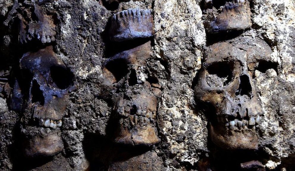
The youngest, the newborn, was buried inside a pot, with other pots around it. The bulbous shape of the pot was thought to imitate the form of a uterus, and it was not clear if the child died before or after birth.
Another offering found at the site included the bones of a bird in a ceramic pot with blue colouring, associated with water.
The older girl was buried with a large clay Aztec-style figurine depicting a female figure holding a child. Her skull showed signs of possible anaemia, malnutrition or infection, signs that suggest life was hard for the Indigenous population in the years following the conquest.
In December, archaeologists announced they had discovered another house site on the outskirts of the city’s centre where 13 large clay ceremonial Aztec incense burners had been carefully buried, again after the Conquest, suggesting that pre-Hispanic beliefs and customs lasted on for some time.
The incense burners had been carefully buried in a pattern that may refer to the Aztec calendar and were covered with adobe bricks as if to hide them.
A U.S. Navy destroyer escort that engaged a superior Japanese fleet in the largest sea battle of World War II in the Philippines has become the deepest wreck to be discovered, according to explorers.
In this Wednesday, June 22, 2022, image provided by Caladan Oceanic, the three-tube torpedo launcher that was part of the USS Samuel B. Roberts can be seen underwater off the Philippines in the Western Pacific Ocean. The U.S. Navy destroyer that engaged a superior Japanese fleet in the largest sea battle of World War II in the Philippines has become the deepest wreck to be discovered, according to explorers. (Caladan Oceanic via AP)
The USS Samuel B. Roberts, popularly known as the “Sammy B,” was identified on Wednesday and broken into two pieces on a slope at a depth of 6,985 meters (22,916 feet).
That puts it 426 meters (1,400 feet) deeper than the USS Johnston, the previous deepest wreck discovered last year in the Philippine Sea also by American explorer Victor Vescovo, founder of Dallas-based Caladan Oceanic Expeditions. He announced the latest find together with U.K.-based EYOS Expeditions.
“It was an extraordinary honour to locate this incredibly famous ship, and by doing so have the chance to retell her story of heroism and duty to those who may not know of the ship and her crew’s sacrifice,” Vescovo, a former Navy commander, said in a statement.
The Sammy B. took part in the Battle off Samar, the final phase of the Battle of Leyte Gulf in October 1944, in which the Imperial Japanese Navy suffered its biggest loss of ships and failed to dislodge the U.S. forces from Leyte, which they invaded earlier as part of the liberation of the Philippines.
According to some records, the destroyer escort disabled a Japanese heavy cruiser with a torpedo and significantly damaged another while battling the group led by the command battleship Yamato.
After having spent virtually all its ammunition, it was critically hit by the battleship Kongo and sank. Of a 224-man crew, 89 died and 120 were saved, including the captain, Lt. Cmdr. Robert W. Copeland.
According to Samuel J. Cox, a retired admiral and naval historian, Copeland stated there was “no higher honour” than to have led the men who displayed such incredible courage going into battle against overwhelming odds, from which survival could not be expected.
“This site is a hallowed war grave, and serves to remind all Americans of the great cost born by previous generations for the freedom we take for granted today,” Cox said in a statement.
The explorers said that up until the discovery, the historical records of where the wreck lay were not very accurate.
The search involved the use of the deepest side-scan sonar ever installed and operated on a submersible, well beyond the standard commercial limitations of 6,000 meters (19,685 feet), EYOS said.
Convert’s ‘Bloody’ Curse Against Robbers Found in Ancient Galilee Grave
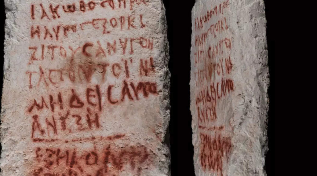
Dated back to the 2nd or 3rd century AD (Late Roman or Early Byzantine period) this painted bloody-looking burial curse inscription was found in a tomb in Beit She’arim Necropolis of Lower Galilee in Israel.
The curse, written in red paint on stone at an ancient grave in Beit She’arim.
The full text and the story of its discovery were presented at the Northern Conference, held jointly on June 1, 2022, by the University of Haifa and the northern region of the Israel Antiquities Authority (IAA).
Though the Beit She’arim necropolis had been studied extensively, the catacomb in which Jacob had been buried had been unknown until last year. This curse was the first inscription archaeologists have found in Beit She’arim for 65 years!
Beit She’arim, located in the Lower Galilee, was a central Jewish settlement during the Mishnaic and Talmudic periods, in the 2nd to 5th centuries CE. The Jewish Sanhedrin Council moved there after the destruction of Jerusalem in 70 CE, the Jewish Sanhedrin Council moved there and it became an important centre of Jewish learning and culture.
Inside the innermost chamber, the researchers discovered two inscriptions written in Greek, in red paint. Both were deciphered by Jonathan Price, professor of ancient history at Tel Aviv University. The small one, was found on the limestone wall near a burial lodge, with the name “Judah” on it, who archaeologists believe was the owner of the tomb.
The larger inscription, which was found on a stone slab leaning against the opening of the same alcove, consisted of the eight lines warning people to stay away from Jacob/Yaakov ‘the Convert’s’ (Koine Greek: ΙΑΚΩΒΟC Ο ΠΡΟCΗΛΥΤΟC) tomb and let the deceased rest in peace.
It was specifically written to deter grave robbers, and as such it says:
“Jacob the Proselyte vows to curse anybody who would open this grave, so nobody will open it. He was 60.”
The last three words of the curse were written in a different script and the researchers believe that they may were written after his death by someone else (possibly relatives), following his demise.
An emblem of a menorah carved in the stone, inside a structure at Beit She’arim National Park, an archaeological site in the Lower Galilee.
Why Proselyte?
This title means that he converted to Judaism, perhaps from Christianity or another pagan cult of the time, such as those of Isis or Mithras that thrived in the Late Roman period. During this period, we know that people were desperately seeking life meaning in different philosophical movements, cults, or religions of the united Roman world.
The Christian faith was growing stronger, however, there are indications that many people in the area choose also to join the Jewish religion. Jerusalem, for instance, is littered with remnants from the burials of converts to Judaism during the second and third centuries AD.
However, converting to Judaism is difficult and involves many serious life changes. After studying Jewish law, converts not only have to hearty accept and be sincerely devoted to the Jewish faith, but they also become members of the Jewish People, and they must embrace the totality of Jewish history and culture.
Greek-speaking areas during the Hellenistic period (323 to 31 BC) Dark blue: areas where Greek speakers probably were a majority Light blue: areas that were Hellenized. Wikipedia.
Why in Greek?
Greek, specifically Koine Greek (Common Greek) served as a lingua franca of the time. Also known as Alexandrian dialect, common Attic, Hellenistic, or Biblical Greek, was the common supra-regional form of Greek spoken and written during the Hellenistic period, the Roman Empire and the early Byzantine Empire.
It evolved from the spread of Greek following the conquests of Alexander the Great in the fourth century BC, and was the language commonly spoken in much of the Mediterranean region and the Middle East during the following centuries, including Roman-period Palestine. It was based mainly on Attic and related Ionic speech forms, with various admixtures brought about through dialect levelling with other varieties.
The excavation of the Beit She’arim ancient necropolis began 80 years ago. The burial inscriptions that were found belong to Jews and are written in various languages, but mostly Greek.
Metal detectorist believes he’s found King John’s 800-year-old lost treasure
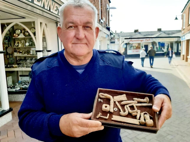
A metal detectorist has begun excavating a farm field where he believes he has found the 800-year-old long-lost treasure of King John. Raymond Kosschuk, 63, has been waiting for two years to get approval from the relevant authorities to begin digging at the site in Sutton Bridge, Lincolnshire.
Raymond Kosschuk with some of the artefacts found in a field he believes holds King John’s treasure.
The mechanical engineer says he is ‘100 per cent certain’ that the medieval artefact uncovered in 2020 at the undisclosed location belonged to the former King of England. King John, who signed the Magna Carta a year before his death in 1216, lost the treasure during an ill-fated crossing of Wash – an estuary that divides Lincolnshire and Norfolk on October 12, 1216.
Dying only a week later at Newark Castle in Nottinghamshire, from dysentery – or according to some historians by drinking poisoned ale – the hoard has been undiscovered ever since. Raymond is convinced he has struck gold after his equipment picked up ‘overwhelming evidence of the controversial monarch’s lost treasure.
Raymond and the farmer have now begun digging out their findings and will submit them to archaeologists and Lincolnshire’s Finds Officer.
Raymond has been waiting to start digging for the last two years
He said: ‘With many ups and downs, the time has finally arrived for what looks and tested to be the prized lost possessions of King John to be excavated from its deep grave of 15 feet below the ground.
‘It will be finally recovered finally this year before the 810th anniversary of its being lost.
‘Nearly two years on from finding the site, and many weeks of testing, and finding other carts of interest but only one proved positive for multiple high-value targets.
‘There is a strong indication that the Royal Regalia is present, along with King John’s 55 rings and many items which have not been seen since, October 1216.
‘All the legal authorities have been contacted as respect to the legal requirements under the 1996 Treasures act, guidelines protocol which are required are being followed.
‘I am excited to be digging.’
Raymond first discovered the site in 2020 after equipment he had invented began to pick up anomalies in the readings of magnetic fields.
So far he has recovered a wealth of artefacts during a quick sweep with a metal detector including hammered blots, nails, an eyelet and even a metal buckle.
Coastal geologists have looked at the core samples taken from the site.
He added: ‘The geologist has confirmed that the ground is consistent with quicksand and they would have gone down quickly.’
He believes that King John had set off from King’s Lynn without a guide and the baggage train, made up of 2,000 people and more than a mile long, was then caught up in a thick fog.
Raymond, of Keighley in West Yorkshire, said previously: ‘In the 13th century they did not have compasses.
‘If the sun was blocked out because of the fog, they would have meandered off.
‘I am 100 per cent certain that this is it. This is the real thing. When I gained access, I isolated an area of high-value targets and it tested positive for elements of gold, silver, emeralds, sapphires and rubies.
‘The biggest attraction of this area I detected an is an accumulation of silver.
‘This tells me there is between 60lb-120lb of silver but it could be more. I believe this was the cash box that King John was carrying.
‘It is sitting out there and if it was so easy to find it would have been found. This has been hidden for 800 years.’
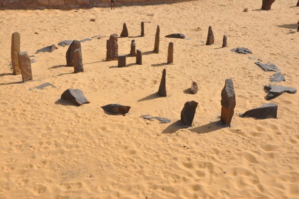
Nabta Playa: The world’s first astronomical site was built in Africa and is older than Stonehenge
Ancient societies all around the world erected massive stone circles like celestial clocks, aligning them with the sun and stars to mark solstices. These early calendars foretold the coming of the seasons, helping civilizations track when to plant and harvest crops. They were also connected with religion and served as special ceremonial sites.
Located in Africa, Nabta Playa was once a large internally drained basin in the Nubian Desert, located approximately 800 kilometres south of modern-day Cairo and about 100 kilometres west of Abu Simbel.
Today the region is characterized by numerous archaeological sites. The Nabta Playa archaeological site, one of the earliest of the Egyptian Neolithic Period, dated to circa 7500 BC.
By the 7th millennium BC, exceedingly large and organized settlements were found in the region, relying on deep wells for sources of water. Huts were constructed in straight rows. Sustenance included fruit, legumes, millets, sorghum and tubers. Also in the late 7th millennium BC, but a little later than the time referred to above, goats and sheep, apparently imported from Western Asia, appear. Many large hearths also appear.
In the 1960s, a prominent American archaeologist named Fred Wendorf wanted to search for the ancient origins of Pharaonic Egypt, away from the Nile River. When he was taken out to the site, he first thought they were natural formations. But he soon realized that the site was once a large lakebed that would have destroyed any such rocks. He would return many times over the course of decades. Then, during excavations in the early 1990s, Wendorf and a team of excavators, including Polish archaeologist Romuald Schild, uncovered a circle of stones that seemed to be aligned with the stars in some mysterious way.
THE FIRST ASTRONOMICAL OBSERVATION
By the 5th millennium BC, these peoples had fashioned what may be among the world’s earliest known archaeoastronomical devices (roughly contemporary to the Goseck circle in Germany and the Mnajdra megalithic temple complex in Malta). These include alignments of stones that may have indicated the rising of certain stars and a “calendar circle” that indicates the approximate direction of summer solstice sunrise. “Calendar circle” may be a misnomer as the spaces between the pairs of stones in the gates are a bit too wide, and the distances between the gates are too short for accurate calendar measurements.” An inventory of Egyptian archaeoastronomical sites for the UNESCO World Heritage Convention evaluated Nabta Playa as having “hypothetical solar and stellar alignments.”
Astrophysicist Thomas G. Brophy suggests the hypothesis that the southerly line of three stones inside the Calendar Circle represented the three stars of Orion’s Belt and the other three stones inside the calendar circle represented the shoulders and head stars of Orion as they appeared in the sky. These correspondences were for two dates – circa 4800 BC and at precessional opposition – representing how the sky “moves” long term. Brophy proposes that the circle was constructed and used circa the later date, and the dual date representation was a conceptual representation of the motion of the sky over a precession cycle.
Near the Calendar Circle, which is made of smaller stones, there are alignments of large megalithic stones. The southerly lines of these megaliths, Brophy shows, aligned to the same stars as represented in the Calendar Circle, all at the same epoch, circa 6270 BC. The Calendar Circle correlation with Orion’s belt occurred between 6400 BCE and 4900 BC, matching the radio-carbon dating of campfires around the circle.
NEW SUGGESTIONS
A 2007 article by a team of University of Colorado archaeoastronomers and archaeologists (three members had been involved in the original discovery of the site and its astronomical alignment) has responded to the work of Brophy and Rosen, in particular their claims for an alignment with Sirius in 6088 and other alignments which they dated to 6270, saying that these dates were about 1,500 years earlier than the estimated dates. The Sirius alignment in question was originally proposed by Wendorf and Malville, for one of the most prominent alignments of megaliths labelled the “C-line”, which they said aligned to the rising of Sirius circa 4820 BCE.
Brophy and Rosen showed in 2005 that megalith orientations and star positions reported by Wendorf and Malville were in error, noting that “Given these corrected data, we see that Sirius actually aligned with the C-line circa 6000 BCE. We estimate that 6088 BCE Sirius had a declination of -36.51 degrees, for a rising azimuth exactly on the C-line average”. Malville acknowledged the corrections made by Brophy and Rosen, but concluded the C-line of megaliths “may not represent an original set of aligned stele; we refrain from interpreting that alignment.”
They also criticised suggestions made by Brophy in his book The Origin Map that there was a representation of the Milky Way as it was in 17,500 BCE and maps of Orion at 16,500 BC, saying “These extremely early dates as well as the proposition that the nomads had contact with extraterrestrial life are inconsistent with the archaeological record. Inference in archaeoastronomy must always be guided and informed by archaeology, especially when substantial fieldwork has been performed in the region.
They propose that the area was first used as what they call a “regional ceremonial centre” around 6100 BC to 5600 BC with people coming from various locations to gather on the dunes surrounding the playa where there is archaeological evidence of gatherings which involved large numbers of cattle bones, as cattle were normally only killed on important occasions.
Around 5500 BCE a new, more organised group began to use the site, burying cattle in clay-lined chambers and building other tumuli. Around 4800 BC a stone circle was constructed, with narrow slabs approximately aligned with the summer solstice, near the beginning of the rainy season.
More complex structures followed during a megalith period the researchers dated to between about 4500 BC to 3600 BC. Using their original measurements and measurements by satellite and GPS measurements by Brophy and Rosen they confirmed possible alignments with Sirius, Arcturus, Alpha Centauri and the Belt of Orion. They suggest that there are three pieces of evidence suggesting astronomical observations by the herdsmen using the site, which may have functioned as a necropolis.
“The repetitive orientation of megaliths, stele, human burials and cattle burials reveals a very early symbolic connection to the north.” Secondly, there is the orientation of the cromlech mentioned above. The third piece of evidence is the fifth-millennium alignments of stele to bright stars.
They conclude their report by writing that “The symbolism embedded in the archaeological record of Nabta Playa in the Fifth Millennium BC is very basic, focussed on issues of major practical importance to the nomads: cattle, water, death, earth, sun and stars.”
Man Finds Secret Window Hidden Behind Wallpaper in 19th-Century Home
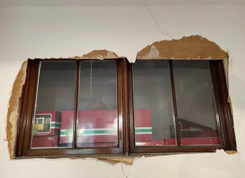
A man discovered a secret window hidden behind wallpaper in his house, thought to date back to the 19th century, as he lovingly renovated the property. Alex Howard is restoring the antique grandeur to his home, in Edinburgh, Scotland, and has been sharing progress to his TikTok page, @housedoctoralex.
Howard, an author, has been painstakingly removing all the woodchip wallpaper throughout the house—similar to popcorn style—when he found something unusual lurking behind the hardboard. He shared a clip of himself up a ladder armed with a wallpaper scraper, as he pokes a hole through the covering, and realizes there’s something on the other side. Howard immediately rips off the wallpaper, shouting “window” as he uncovered the black-rimmed frame. He captioned the video, which can be seen here: “Wtf I found a hidden window in my flat,” adding: “Well that was unexpected.”
In the comments, he revealed the woodchip was “getting steamed off and re-lined next month,” explaining the window was covered by flimsy sheets of hardboard. Speaking to Newsweek, Howard explained the two-bedroom apartment was built around 1890, and he and his wife are slowly returning it to its former glory after it’s “no doubt been home to countless students and tyrannical landlords over the years.”
He said: “There’s nearly always a window connecting the kitchen alcove and a box room (which has often been converted into a kitchen bathroom). Presumably, it was the Victorian idea of giving that little interior space some natural light. In fact, I learnt only yesterday they are called ‘borrow windows,’ presumably because you’re borrowing light from another room.
“When we arrived, I did that classic ‘dad’ thing of tapping up the wall to hear if the tone changed. Sure enough, I discovered that the window had just been dry-walled over. The fact that there was then a layer of woodchip on top of that, suggests that it was done at least as far back as the 70s.”
He added the glass was single-glazed, saying: “They’re that old pre-war ripply glass like all the windows in this flat. All our windows make things look a bit wibbly, and distorted when you look through them because of the more unrefined, pre-war glazing techniques. You can see the oddly replaced pane because it doesn’t distort.”
Photo of the hidden windows. Alex Howard discovered secret windows lurking underneath wallpaper in his 19h-century house.
The clip, shared in June, amassed more than 400,000 views, and people were so intrigued that Howard shared a follow-up clip. It shows he found a pair of windows, with two panes each, covered up between two rooms.
“So some of you have been asking about the backstory to these here windows that I discovered yesterday,” he said.
Howard, who moved in two months ago, gave viewers a mini-tour, saying: “I’ve worked it out, follow me down the hall, and into the box room. But why you might say might one block windows to a box room.
“It was once a bedroom. The reason I know is that up here there’s a light switch which controls the lights in the room. This means at some point there was a mezzanine level up here with a bed installed when this was rented out as its own separate bedroom.
“Some of you may have heard of HMO, or houses in multiple occupancies, before this was introduced any room could be rented out to someone regardless of whether or not it had a window in it. Thankfully we live in more enlightened times now and you can only let out a room if it’s got a window.”
It’s thought that as the window connects two rooms, rather than leading to the outside, they were covered to give each tenant privacy.
Howard explained: “This is what we’re putting the blocked-up window down to—the room on the other side is a box room with its plug sockets/switches mounted high up the wall. We reckon it was rented out as a room with a mezzanine bed, pre-HMO regulations when landlords crammed these flats full of students to cash in.
“But what is clear is that the blocked-up window is an attempt to make that postage stamp of a box room ‘private.’ Pretty sad to think that tiny, windowless space was some poor student/servant’s room at one point!”
He added that the smaller room was what the U.K. refers to as a “box room,” which is essentially a glorified cupboard, which is why the bed was on a mezzanine.
Howard clarified they’re “just a bit bigger than a walk-in cupboard,” adding: “They’re small rooms, bigger than a cupboard but smaller than a conventional room, that was traditionally used for lodgers. This one’s about 6×5.'”
Numerous people commented on the original clip, with Liam Burgeson asking: “Who does these things.”
Mecha_genki said: “We had this too! Didn’t notice it because it was on the side we never went down”
While MissMisty wrote: “Why was the window covered in craft paper? Lean against it too hard and your arm would go through.”
Marvin Harold joked: “Previous owner must have worked nights.”
Burial Mounds in Serbia reveal skeletons of 5,000-year-old painted men
Archaeologists have discovered dye-coloured bones dating back around 5,000 years at a burial site in southeastern Europe where unusually tall men were laid to rest.
A reconstruction of the tomb and one of the immigrants from the northeast steppes was found in the sacred burial mounds on the plains of Serbia.
The burial site, located in Vojvodina in northern Serbia, was excavated by researchers between 2016 and 2018. However, only recently was expert analysis carried out.
The burial site consisted of two large mounds 131 feet across and between 10 and 13 feet tall.
Inside, the researchers found that some bones were marked with red colouring, thought to be due to “the use of ochre on the bodies of the dead,” according to Piotr Włodarczak from the Institute of Archaeology and Ethnology of the Polish Academy of Sciences, one of the excavation supervisors, in a statement to the government-affiliated Science in Poland public information service.
Ochre is a type of earth that has been coloured by iron oxide. This can give it a red hue and it has been used as a colouring pigment. Red in particular was considered sacred by some, Włodarczak said.
Another thing the researchers noticed about the remains is that the deceased men were over 1.8 meters tall, or around 5 ft. 11 in. This would have been an above-average height for the time—it’s thought that the men were buried around 3,000 BCE, and men living in this part of Europe then would usually have been about 1.6 meters or 5 ft. 3 in. tall, according to Science in Poland.
The height of the men, as well as the use of ochre, led the researchers to believe that they were newcomers to the region and had probably come there from the steppes of what would be south Russia or Ukraine today.
Genetic analysis of the remains suggested the men had themselves come from this region or were immediate descendants of people who did.
The influx of nomads from eastern to more western parts of Europe in this period would have had a significant impact on the culture of Europe, Włodarczak said.
It’s not the only significant archaeological finding to be reported recently. In the United Kingdom last week, a Roman mosaic hidden beneath the streets of London for more than 1,500 years was discovered.
The 26-foot-long mosaic was found at a construction site near the capital’s largest building, The Shard. It’s set to be transported for preservation later this year and there are hopes it will be publicly displayed in future. It’s thought that the mosaic may have been part of a large dining room called a triclinium.
A stock photo shows an archaeologist using a brush to carefully examine something in the ground. Archaeologists in Serbia have found burial sites of people who are thought to have travelled there thousands of years BCE.
Pottery Analysis Offers Clues to Caribbean Island Trade Routes
With some 7,000 islands and cays and 7,000-year history of human habitation, the Caribbean Sea is practically synonymous with maritime travel. The very word “canoe” is derived from the term “kana:wa,” used by the Indigenous Arawakans of the Caribbean to describe their dugout vessels.
Without clear road signs to indicate where native islanders were travelling, however, the task of reconstructing ancient trade routes relies on subtle clues locked away in the archaeological record. Researchers at the Florida Museum of Natural History recently turned to pottery to tease apart the navigational history of the Caribbean, analyzing the composition of 96 fired clay fragments across 11 islands.
The study, published in the Journal of Archaeological Science: Reports, is the broadest of its kind yet conducted in the Greater Antilles and marks the first time that pottery artefacts from the Lucayan Islands — The Bahamas plus the Turks and Caicos Islands — have been analyzed to determine their elemental composition and origin.
Pottery from the Caribbean are relatively durable and are often the most common artifacts unearthed from archaeological sites.
“Our methods mark a big improvement over other studies that mostly look at a single site or single island, where you might see differences but not know what it means because you’re looking at the results in isolation,” said co-author Lindsay Bloch, a courtesy faculty member with the Florida Museum’s Ceramic Technology Lab.
People have lived on the Caribbean islands on and off for more than 7,000 years, migrating in waves from Central and South America. As early as 800 B.C., new groups arrived from Venezuela and established a trading network among islands, which they used to exchange food, tools and jewellery. But the most common artefacts that survived to the present are the pottery vessels these objects were carried in.
“Most materials don’t preserve well in the Caribbean because of the warm, humid environment, but pottery is durable, so it ends up being one of the most common things we find,” said lead author Emily Kracht, a collections assistant in the Ceramic Technology Lab.
Over the ensuing millennia, different Caribbean cultures developed unique styles and techniques for constructing their pottery. Some artefacts are simple and unadorned, while others are highly decorated, with a lattice of incised lines, punctuations, raised ridges and flared rims.
Indigenous Caribbean islanders developed elaborate and ornate pottery styles that varied across time and between cultures.
Many studies have relied almost entirely on similarities in style to distinguish between different cultures and infer their movements. But, as Bloch explains, this method has often left more questions than answers and excludes material with potentially valuable information.
“The vast majority of pottery that we find anywhere in the world is going to be undecorated. It’s going to be things used for cooking or storage, which are typically plain and often get ignored because they’re seen as generic,” she said.
Rather than studying the minutiae of varying styles, the researchers focused instead on what the pottery was made of. Using a laser to etch microscopic lines into their samples, the researchers determined the exact amounts and identities of each element in the clay used to make the pottery. Their final analysis included more than seven decades’ worth of archaeological collections that span over 1,000 years of Indigenous Caribbean history.
“One of the advantages of elemental analysis is that we’re explicitly looking for differences, which allows us to see where a pot was made and compare that to where it ended up,” Bloch said.
The researchers removed small fragments from pottery vessels and embedded them in resin before analyzing their elemental composition.
Lead author Emily Kracht prepares the resin blocks and embeds pottery fragments for elemental analysis.
Such detailed comparisons are possible due to the complexity of the Caribbean’s underlying geology. The largest islands in the archipelago likely got their start as an ancient underwater plateau in the Pacific Ocean. After the breakup of the supercontinent Pangaea, the Caribbean plate drifted east in a flurry of volcanic eruptions that elevated the plateau above sea level before ultimately reaching its current position in the Atlantic.
Millions of years of weathering reduced these volcanic outcrops into fine-grained clays with differing concentrations of elements like copper, nickel, chromium and antimony. These differences mean that even the smallest Caribbean pottery sherd bears the elemental signature of the region it was made in.
The results of researchers’ comparative analysis aren’t what might be expected by simply looking at a map. The Lucayan Islands were initially used only temporarily for harvesting resources, and the people who travelled to them would have set sail from the larger islands to the south that supported permanent population centres.
Cuba might initially seem like it’s the perfect staging ground for these operations, being by far the largest Caribbean island and the closest to The Bahamas. While people did make the trek across open water from Cuba, the results of the study indicate the Caribbean’s cultural hub was instead centred on the northwest coast of Hispaniola, from which people imported and exported goods for hundreds of years.
“At least some of the pottery would have been used to ferry goods out to these islands, and people would potentially carry back a variety of marine resources,” Bloch said.
People eventually struck up permanent settlements in The Bahamas and Turks and Caicos, becoming collectively known as the Lucayans, or the People of the Islands. They began making their own pottery from claylike soils deposited by African dust plumes blown in from the Saharan Desert, but the results didn’t quite hold up to the pottery from Hispaniola — literally. Lucayan pottery, called Palmetto Ware, is most often thick and soft and crumbles over time due to the poor quality of the grainy Saharan soil.
Thus, up until the arrival of the Spanish, Hispaniola remained the main trading partner and exporter of pottery to the Lucayan Islands.
“We knew that the Lucayans were related to people in Hispaniola, and this study shows their enduring relationship over hundreds of years through pottery,” Kracht said.