Thousand-year-old bone skate discovered in Czech Republic
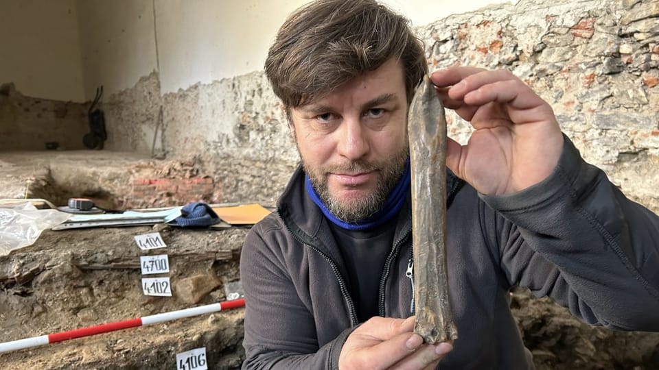
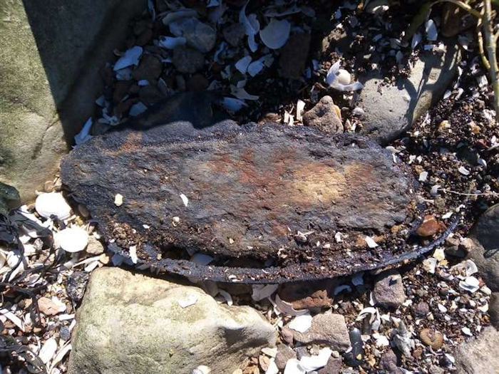
Archaeologists from the central Moravian city of Přerov, Czech Republic have announced a unique discovery. While carrying out excavations in the center of the town, they found an ice skate made of animal bone dating back some 1,000 years.
In Přerov, a town on the River Bečva, specialists from the Comenius Museum have been conducting rescue excavations in the basement of a home on the Upper Square of the city.
The skate was made of animal bone, likely the metacarpal (shin bone) of a horse. Fragments of pottery found around the blade date it to the 10th or 11th century.
This find, offers a rare glimpse into the ingenuity and daily life of early medieval societies.
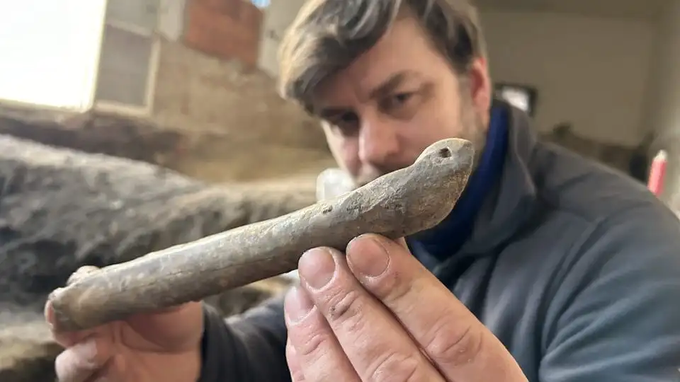
Archaeologist Zdeněk Schenk says it was most likely made of horse shin bone: “The object has a specific shape. On one side, it is curved into a tip which has a hole drilled in it and there is another hole at the back. They were used to thread a strap through, which was used to attach the skate to a shoe or to a wooden sledge.”
Unlike their modern counterparts used for recreation, these ancient blades served a more practical purpose, explains Schenk. “People back then wouldn’t have used them for leisure skating,” he clarifies. “Instead, they’d shuffle across frozen surfaces with the aid of sticks, or even attach them to sleds for transporting goods over ice.”
The bone blade is not the first such object found in Přerov. A similar find was made there in 2009 and more such blades have been unearthed over the years in the wider area of the city. Zdeněk Schenk says this is probably due to its location: “The Upper Square sits on a hill overlooking the Bečva River,” he explains. “In those times, settlements clustered along the river’s branches, making winter travel on the frozen water a necessity.”
Schenk emphasizes that Přerov isn’t alone in these discoveries. “Similar ‘ice skates’ made from cattle or horse bones have been found across Europe, particularly in Central and northwestern regions like Scandinavia.
Interestingly, many of these finds date to the 10th century and often appear in Viking settlements.”
The thousand-year-old skate discovered by archaeologists in Přerov will soon be shown to the public. The bone skate will go on display at the Comenius Museum in Přerov Castle.
World’s First Pregnant Ancient Egyptian Mummy has been Discovered
Experts from the Polish Academy of Sciences aim to research all mummies in museums as part of the Warsaw Mummy Project. As part of this project, researchers worked to discover more about the woman thought to be in her 20s.
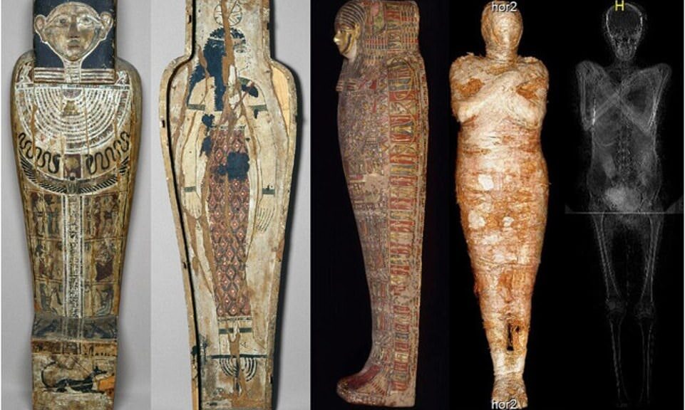
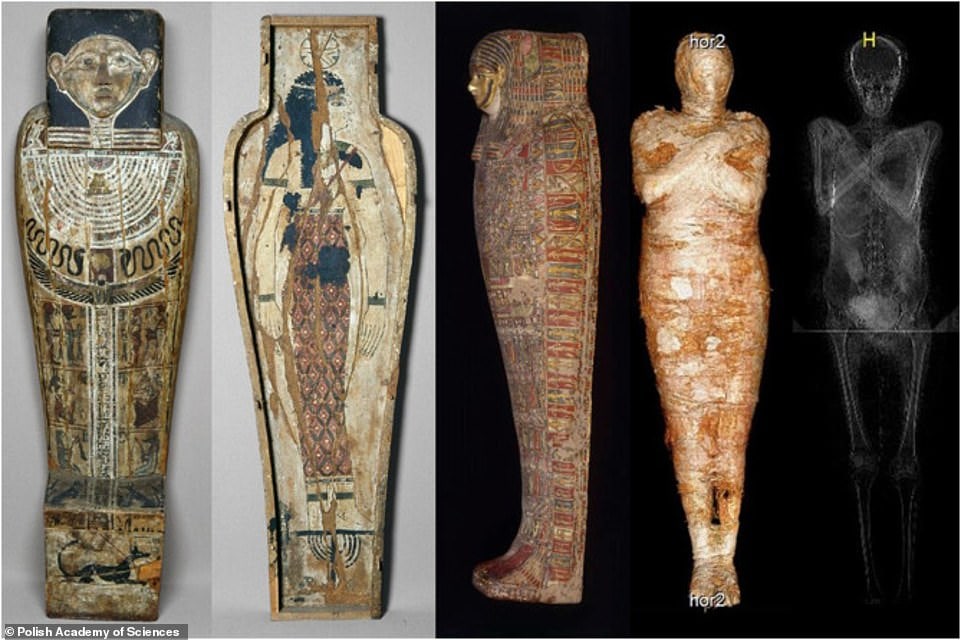
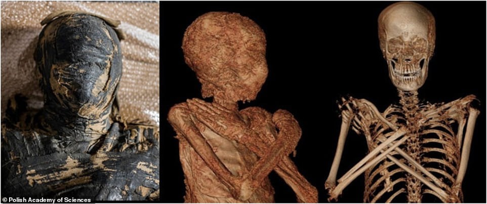
The first mummified bones of an ancient Egyptian pregnant woman dating back over 2,000 years have been found in Thebes. According to scans of the body, she died at the age of 28 weeks pregnant.
The team found the remains of a fetus, estimated to be 26 to 30 weeks old, inside the woman using a combination of CT scans and X-rays. The first time a pregnant mummy has been discovered.
According to the authors of a paper published in the Journal of Archaeological Science, the body of the woman who died 2,000 years ago was carefully wrapped in fabrics and left with a rich collection of amulets to see her into the afterlife.
The team can’t say why the fetus was left inside the woman and not mummified separately, but it could be because it was too young to have a name and needed to travel to the afterlife inside its mother.
Study lead author Dr. Wojciech Ejsmond said this was the ‘first discovery of a pregnant embalmed body,’ adding: ‘There is no other so well preserved ancient body of a pregnant woman.
The body was wrapped in fine fabrics and laid to rest with a set of amulets representing Horus’ four sons, which the team believes indicate she was a powerful figure in Thebes.
The head and CT scans the mummy. The first remains of an ancient Egyptian mummified pregnant woman have been discovered in Thebes, dating back more than 2,000 years, the corpse was 28 weeks into her pregnancy when she died.
According to the study writers, the mummy was discovered in royal tombs in Thebes, Upper Egypt, and came from the elite of the Theban culture.
The woman was transported to Warsaw, Poland, in 1826, at the time of some of the most famous Egyptian Valley of the Kings findings, and is now on display at the National Museum in Warsaw.
‘This mummy provides new possibilities for pregnancy studies in ancient times, which can be compared with and related to current cases,’ study authors wrote.
‘Furthermore, this specimen sheds a light on an unresearched aspect of ancient Egyptian burial customs and interpretations of pregnancy in the context of ancient Egyptian religion.’
‘For Egyptologists, this is a fascinating discovery because we know little about perinatal health and childhood in ancient Egypt,’ Dr. Ejsmond added.
‘Physicians can study, for example, the intestinal content of the fetus to gather information on the development of the immune system in ancient times.’
The fetus was mummified alongside its mother in the lower part of the lesser pelvis and partly in the lower part of the greater pelvis. It was not, however, removed from its original location.
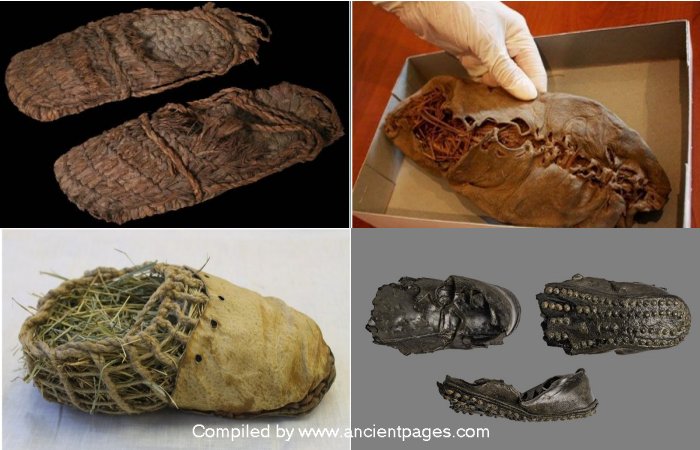
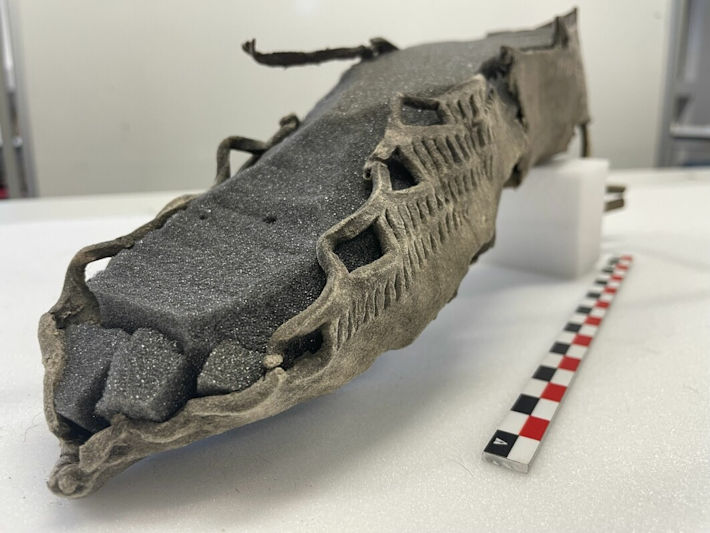
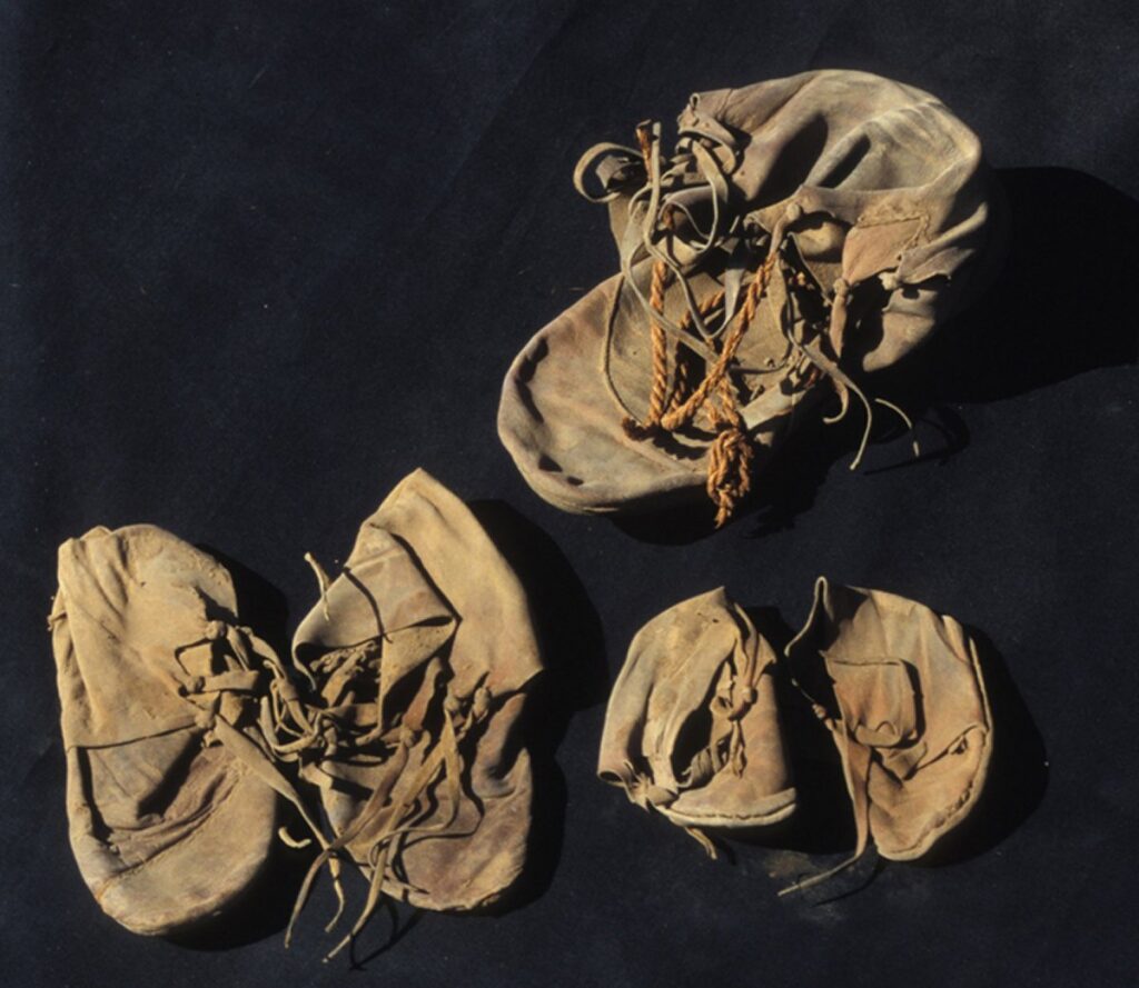
World’s Oldest Shoes: Some Look Surprisingly Modern
More than 700 years ago today, on May 20, 1310, shoes were made for the first time for both right and left feet. Before that, unfortunately, they weren’t.
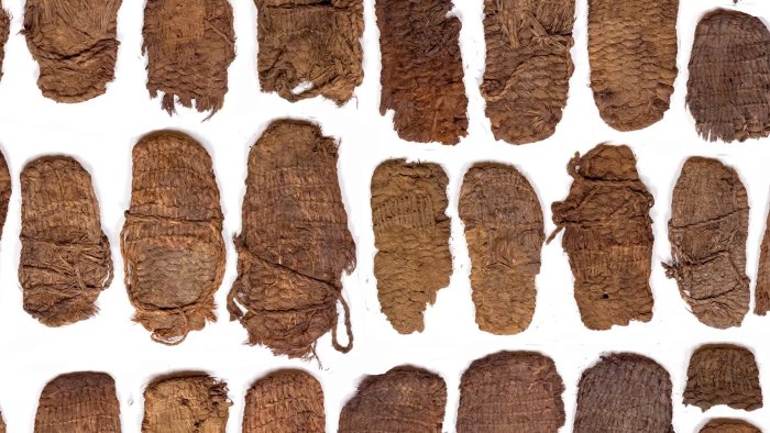
Archaeologists have discovered several very old shoes in many parts of the world. Some of the shoes are thousands of years old and in remarkably good condition. Here we present some of the oldest shoes discovered worldwide, and as you can see, some of them look surprisingly modern.
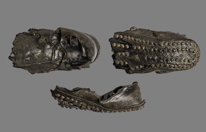
The Areni-1 shoe: World’s Oldest Shoe Was Found In A Cave In Armenia
A researcher holds the ancient shoe at the Armenian Institute of Archaeology and Ethnography.
Part of figure 1 from: 2010 First Direct Evidence of Chalcolithic Footwear from the Near Eastern Highlands.
The world’s oldest shoe was discovered in Armenian cave and is around 5,500 years old. It’s older than the ancient Egyptian pyramids and Stonehenge. Known as the Areni-1 shoe, the moccasin-like shoe is compressed in the heel and toe area, likely due to miles upon miles of walking. However, the shoe is by no means worn out, and it’s still in very good condition. Researchers and designers have emphasized it is astonishing how much this shoe resembles a modern shoe.
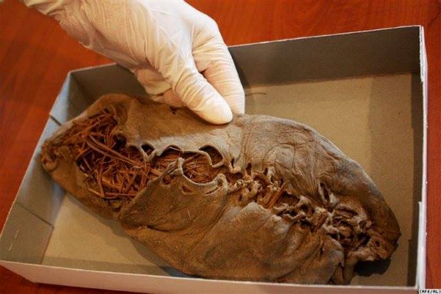
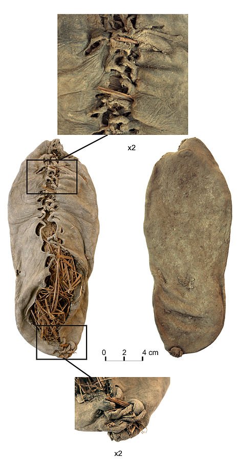
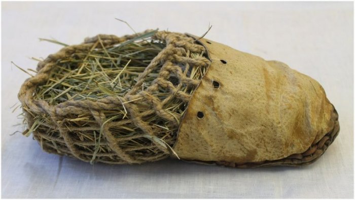
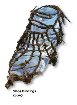
Iceman Ötzi’s Shoes
The Iceman Ötzi’s shoes were long regarded as the oldest known shoes until the discovery of the 5,500-years old Armenian shoes. Ötzi’s shoes are sophisticated and consist of an inner and outer part.
The inner shoe is composed of grass netting. Its purpose was to hold hay in place, which served as insulation material. The outer part is made of deerskin. Both parts – the grass netting and the leather upper – are fastened to an oval-shaped sole made of bearskin by means of leather straps. Unlike the sole, the uppers were worn with fur on the outside. The shaft around the ankle was bound with grass fibers.
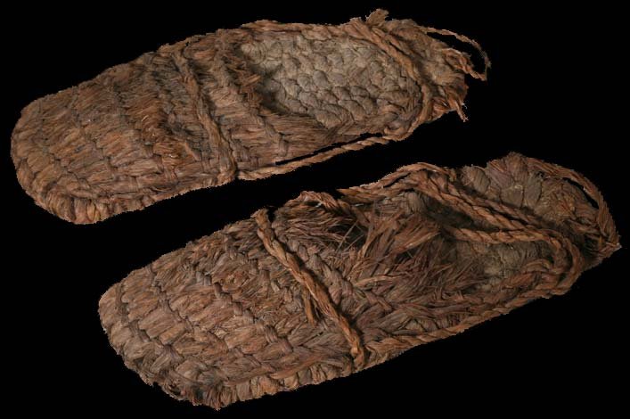
World’s Oldest Sandals Were Discovered In Fort Rock Cave, Oregon
The word sandal derives from the Greek word sandal. The ancient Greeks distinguished between baxeae (sing. baxea), a sandal made of willow leaves, twigs, or fibers worn by comic actors and philosophers, and the cothurnus, a boot sandal that rose above the middle of the leg, worn principally by tragic actors, horsemen, hunters, and by men of rank and authority. The sole of the latter was sometimes made much thicker than usual by the insertion of slices of cork, so as to add to the stature of the wearer.
Sandals were popular among ancient Egyptians. They wore sandals made of palm leaves and papyrus.
The world’s oldest sandals were discovered in 1938 by anthropologist Luther Cressman in Fort Rock Cave, Oregon, United States. Cressman came across dozens of sandals and fragments of sandals inside the cave. They were found beneath a layer of volcanic ash, which was later identified as coming from the eruption of Mount Mazama.
Cressman believed that the sandals were ancient, but because radiocarbon dating would not be developed for another decade, his conviction would not be confirmed until 1951, when fibers from the sandals themselves were dated to more than 9,000 years old. Fort Rock sandals are made of shredded sagebrush bark. They are twined, with pairs of fiber wefts twisted around passive warps, in contrast to simple over-and-under interlacing or plaiting, known as wickerwork.
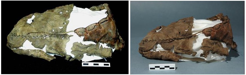
3,000-Year-Old Shoe Found On A Beach In Kent, UK
The shoe as it was found on a foreshore in North Kent.
The shoe as it was found on a foreshore in North Kent. Credit: Steve Tomlinson Britain’s oldest shoe has been found on a beach in Kent. The shoe, made of leather, is 3,000 years old and was discovered by archaeologist Steve Tomlinson.
When Tomlinson found the shoe, he did not think it was special, but he sent it for carbon dating at an East Kilbride, Scotland unit. Five weeks later, he received a reply stating the shoe was from the late Bronze Age.
1,700-Year-Old Roman Shoes Found In France
Roman shoes were discovered in the channeled channel of the “Lys” during the excavation of Thérouanne (Pas-de-Calais) in 2023.
Archaeologists excavating in the small village of Thérouanne, located on the river Lys in the Pas-de-Calais department in the Hauts-de-France region of France have made some fascinating discoveries. Scientists unearthed 1,700-year-old Roman shoes that are still in good condition and an exceptional glass workshop.
Startling Roman-Looking Sandal Discovered Buried Deep Beneath The Snow In Norwegian Mountains
Together with a number of other items that melted out of the ice during the warm summer of 2019, this shoe helped the glacial archaeologists in the Secrets of the Ice program find an old forgotten mountain pass leading from inland Norway and all the way out to the coast.
Team Secrets of the Ice has been searching for clues about the past in the Norwegian mountains for 15 years, and during this time the scientists have made many unusual discoveries.
Among the most significant finds are the hundreds of pre-historic cairns, which are stone structures that signaled to the travelers where the route went, a lost Viking settlement, an iron horseshoe as well as ancient textiles.
One curious find is the startling Roman-looking sandal that scientists found buried deep beneath the snow in an ancient, dangerous Norwegian mountain pass.
Oldest Shoe Discovered In Canada
The oldest shoe discovered in Canada is a 1,400-year-old made of deerskin found in a glacier region.
In 2004, an Italian archaeological team discovered ancient shoes that were deliberately hidden in an Egyptian temple.
The two pairs of children’s shoes were among the seven found concealed in a jar placed into a cavity between two mudbrick walls in a temple in Luxor, the site of the ancient city of Thebes.
Oddly, the shoes were tied together using palm fiber string and placed within a single adult shoe. A third pair that an adult had worn was found alongside them. The shoes were obviously of foreign origin, as they were concealed at a time when most Egyptians would normally have worn sandals. The shoes were expensive and in pristine condition, at least at the time of discovery. Unfortunately, after they were unearthed, the shoes became brittle and ‘extremely fragile,
Who the owner of the shoes was has never been determined. “The shoes were eye-striking at the time. If you wore such shoes, “everybody would look at you,” wrote Dr. Veldmeijer, assistant director of the Netherlands-Flemish Institute in Cairo and an expert in ancient Egyptian footwear in the Journal of the American Research Center in Egypt.
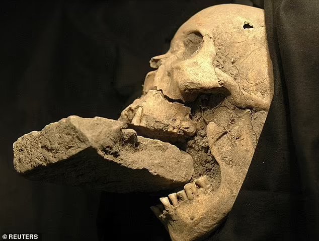
Scientists Reconstruct Face Of 16th Century Italian ‘Vampire’ Buried With Brick In Mouth
A 16th-century ‘vampire‘ who was buried with a stone brick jammed in her mouth over fears she would feed on corpses underground has had her face reconstructed by scientists.
A facial reconstruction expert reconstructed the features of the female corpse discovered in a mass grave of plague victims on the Venetian island of Lazzaretto Nuovo. Brazilian forensic expert and 3D illustrator Cícero Moraes applied features to the woman, who was unearthed in an archeological dig in 2006.
Incredible new images – made using 3D scans of her ancient skull – reveal a woman with a pointed chin, silver hair, wrinkled skin, and a slightly crooked nose.
Moraes was also able to test the theory of whether it would even be feasible to put a brick in someone’s mouth thanks to this research.
Researchers think the brick was put there shortly after she died by locals who feared she would feed on fellow victims of a plague that swept.
Forensic anthropologist Matteo Borrini led the exploration of the mass grave from the 1576 outbreak of plague. “Vampires don’t exist, but studies show people at the time believed they did,” Morrini said in a statement in 2009, after studying the case for 2 years. “For the first time, we have found evidence of an exorcism against a vampire.”
The remains of a female ‘vampire’ from 16th-century Venice, buried with a brick in her mouth allegedly to prevent her feasting on plague victims.
Skeletal evidence already suggests she was 61 years of age at the time of death, and further studies revealed that the skull belonged to a woman of European ancestry. An analysis of her diet shows she mainly ate grains and vegetables, suggesting she was from Europe’s lower class at the time.
Researchers theorize that a gravedigger may have wedged a rock between the corpse’s teeth to prevent the alleged vampire from chewing through her shroud and infecting others with the plague.
During this time in European history, there was a rise in vampire hysteria as villagers started looking for paranormal reasons to blame for the fatal illnesses that were ravaging the continent.
It is believed that the vampire theory was disseminated by Italian gravediggers who frequently encountered horrifying decaying bodies when reopening mass burials to accommodate additional corpses.
The idea that these decaying remains were feasting on the blood of their grave-mates was reinforced by the way they frequently looked horribly bloated, with bodily fluids oozing from their mouths and noses. It’s possible that the shrouds covering the corpses’ mouths disintegrated in some instances, giving rise to the theory that vampires gained their strength by consuming these fragments of cloth.
Recreation of the woman’s face using 3D software allowed examination of whether a brick could have been inserted into her mouth.
“The researchers found that when they observed the body with the shroud, those responsible for the burial noticed a depression in the mouth region, indicating potential chewing,” study authors write in the journal OrtogOnline.
“By supposedly identifying a vampire, one of the culprits of the plague according to the popular myth of the time, they introduced the stone as an element of protection, preventing it from feeding and also from infecting other people.”
In order to ascertain whether the brick could have been purposefully placed into the woman’s mouth after her death, Moraes replicated the brick using Styrofoam and carried out a number of tests. Their tests revealed that the brick could be wedged into a human mouth without causing damage to the teeth or soft tissue. Compared to the team’s living test subjects, the study authors believe it would have been even easier with the corpse, although it’s still unclear if this was done intentionally or not.
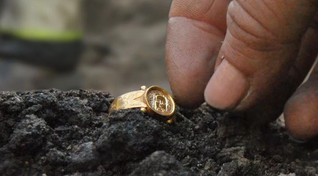
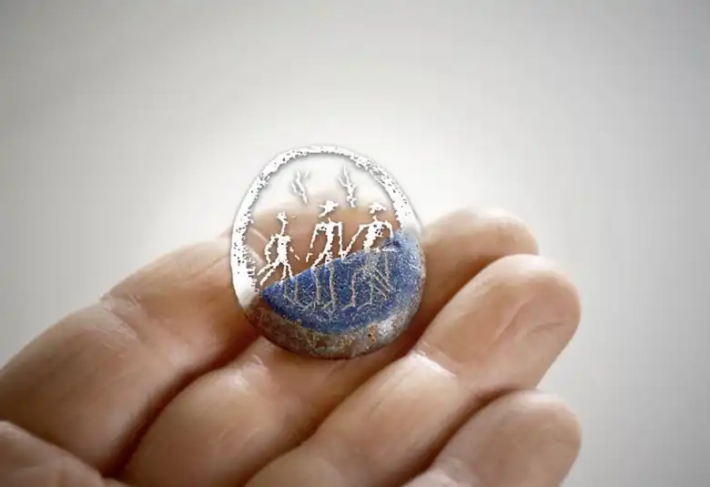
Unique Gold Ring and Crystal Amulet among 30,000 Medieval Treasures Uncovered in Sweden
In the Swedish medieval city of Kalmar, archaeologists from the State Historical Museums unearthed the remains of over 30,000 objects during a two-year project. A gold ring and a crystal amulet with carved figures are two unique finds among the nearly 30,000 objects.
Archaeologists have excavated parts of around 50 medieval plots, a dozen streets, and sections of the old city wall. This project, offers a glimpse into everyday life spanning approximately 400 years, from 1250 to 1650.
Project director of Arkeologerna, lead archaeologist Magnus Stibéus said, “We’ve been able to lift the lid on the city’s medieval past and have had the opportunity to study how people lived, what they ate and drank, and how this changed over time.
Archaeology becomes like a peephole into medieval history, giving us more insight into how life was hundreds of years ago,”.
Remarkable discoveries include a rare glass alsengem and a gold ring that were found in refuse deposits.
The gold ring, adorned with a Christ motif, dates back to the 15th century and is believed to have been worn by a woman due to its petite size. they believe it was lost, given its near-perfect condition. Similar rings have been found in other regions, including Northern Finland, Östergötland, and Uppland.
The amulet fragment, in the image digitally completed to reconstruct its original appearance.
A second standout discovery: an alsengem, also known as a pilgrim’s amulet, with three carved figures. Alsengemmer are small crystal stones found in both religious and secular contexts.
Dating from the 13th to 14th century, it features three intricately carved figures. The stones are named after the Danish island where they were first discovered. The small glass stone is broken, so it was likely thrown away around 400 years ago, officials said.
Among the finds were numerous cannonballs, musket balls, pistol bullets, swords, and other artifacts from the 1611 Kalmar War, in which the Danes attacked the city. An unusual rune stone was discovered among the ruins.
The excavations have provided a comprehensive view of medieval Kalmar, with remnants of buildings, cellars, streets, latrines, and other everyday items. Magnus Stibéus said: “It is very unusual for such large contiguous areas to be investigated in the middle of a city, and the result exceeds all expectations.”
The ability to simultaneously investigate such extensive parts of the medieval city makes the project unique.
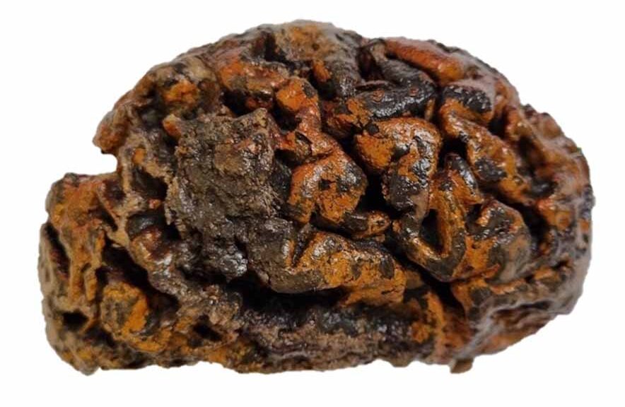
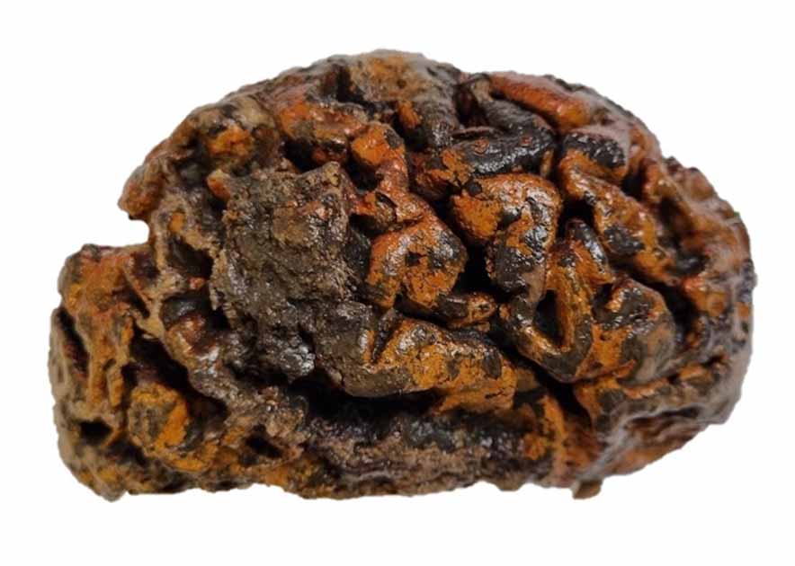
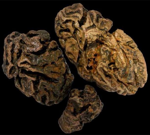
New study: Human brains preserve in diverse environments for at least 12 000 years
A study by forensic anthropologist Alexandra Morton-Hayward and her team from the University of Oxford has shown that the human brain can survive the test of time far better than previously believed. This finding shows that human brains are surprisingly resistant to disintegration, which is a sharp contrast to previous theories.
Researchers, canvassed archaeologists around the world for this research project, resulting in a global archive collating records—and some specimens—of more than 4,400 preserved human brains.
These brains, found across diverse environments—from the icy terrains of the North Pole to the dry deserts of Ancient Egypt—challenge the notion that brains are among the first organs to decompose.
The brain is usually one of the first organs to decompose following death. Thus, the perception persists that naturally preserved brains are “unique” or “extremely rare” discoveries, particularly in the absence of other soft tissues. However, recent research challenges these perceptions, demonstrating that preserved brains exist in far greater abundance than previously thought, thanks to conditions that prevent decay.
Morton-Hayward says these ancient brains might be an untapped source of information about the past.
The preserved brains displayed a variety of conditions, with textures ranging from brittle and dry to soft and spongy. Surprisingly, a significant portion of these brains were discovered in bodies where no other soft tissues survived, presenting an unusual phenomenon in the realm of archaeological discoveries.
Researcher Alexandra Morton-Hayward shows the remains of a 200-year-old brain preserved in formalin.
Morton-Hayward, in an interview with Science: The brain usually just liquefies almost immediately. But I sometimes had autopsy cases where the body had been opened up but the brain was still perfect, like a jelly in the skull.
When I went looking in the literature, I was surprised to find a lot of examples of preserved brains. I eventually found thousands, going back 12,000 years, and from every continent except Antarctica. “Yet no one is investigating this material,” said.
“I think what’s intriguing about this research is that although we know the brain can liquefy quickly, clearly, in some circumstances, it also preserves and on incredibly long timescales,” Morton-Hayward told Science. “So, I would argue that we need to start thinking in greater depth about soft tissue preservation.”
Though less than 1 percent of the archive is currently being studied, the sheer volume of preserved brains has opened up new research opportunities.
The factors like freezing, tanning, and dehydration that help preserve them are being closely examined. Yet, what makes brains endure when other organs do not remains a mystery. This mystery could lie in the brain’s unique brain’s distinct chemical composition, particularly its balanced ratio of proteins to lipids, which may interact with environmental factors such as metals, resulting in preservation.
Fragments of a brain from an individual buried in a waterlogged Victorian workhouse cemetery (UK), some 200 years ago were the only soft tissue not totally dissolved.
Therefore, Morton-Hayward’s ongoing research represents an “untapped archive” that could shed light on human evolution, as well as help us to better understand ancient health and disease.
The research could even provide insights into neurodegenerative conditions that affect people today, such as Alzheimer’s and other forms of dementia.
As Morton-Hayward notes, “Ancient brains may provide new and unique paleobiological insights.” This research could revolutionize our understanding of neurological development and disorders, offering a window into the health and lifestyle of our ancestors.
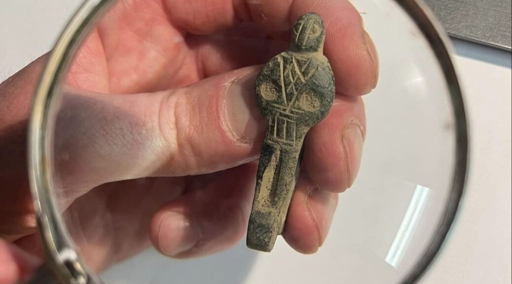
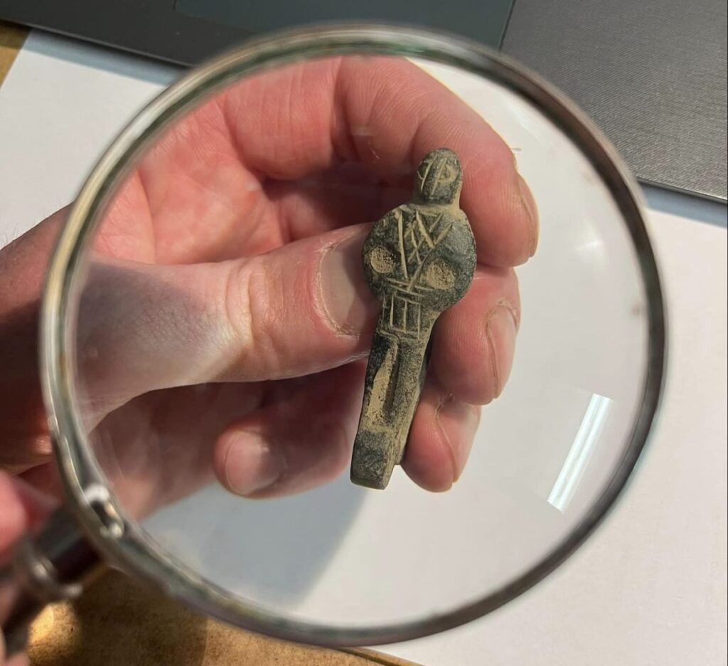
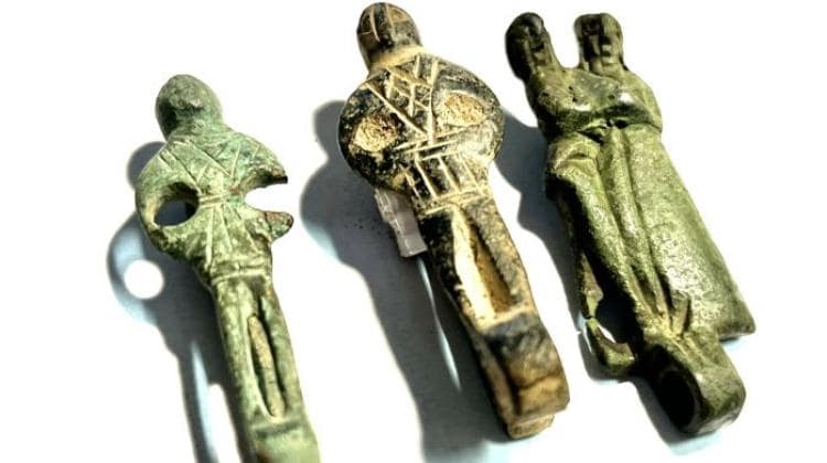
An extraordinary medieval belt loop found near Kamień Pomorski in Poland
A late medieval belt loop for hanging keys or a bag was found near the town of Kamień Pomorski in the West Pomeranian Voivodeship in northwestern Poland. So far, only 15 artifacts of this type have been discovered in Europe.
The discovery was announced on social media by the Museum of the History of the Kamieńska Land. The director of the museum, archaeologist Grzegorz Kurka, described the find as “extraordinary“.
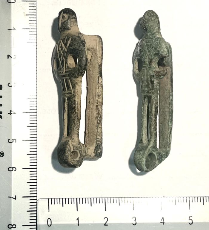
In German literature, artifacts of this type are called anthropomorphic Gürtelhaken, Figürliche Schlüsselhalter, and Schlüsserhaken. The 56 mm high loop is in very good condition.
The front panel has an anthropomorphic form. The figure’s head is schematically marked. Hands are on hips. Protruding from the hip, they form an arc with holes of 4 mm in diameter.
There are diagonal and horizontal cuts visible on the torso and hips – schematically creating a costume typical of the late Gothic era. Below the costume, there is a vertical hole 13 mm long, and directly below it a hole probably intended for hanging keys or a purse (hole 4 mm in diameter).
These hooks or clamps can be divided into two large groups: (loving) couples of men and women embracing (dancing?) and single men who look at the viewer and, in frequent cases, put their hands on their hips.
Based on the circumstances of the find and studies of the clothing components, some of which are depicted in much greater detail, they are usually dated to the second half of the 15th century or the first half of the 16th century. In the specialist literature, Nuremberg is usually assumed to be the place of manufacture.
Based on better or completely preserved examples, we know that a screwable axle was attached through the sleeve-like opening running across the bottom of the figures, to which a mostly oval bracket was attached, as is still the case today with some key rings or key rings.
This also led to the interpretation that such hooks were worn (clipped on) to strong leather belts, but could also be removed at any time. Keys, pouches, or small bags made of fabric or leather could be attached to the hanger.
Copperplate engravings and woodcuts from the 15th and 16th centuries show that men and women carried all kinds of things on their belts, including knives, cutlery, and individual spoons.
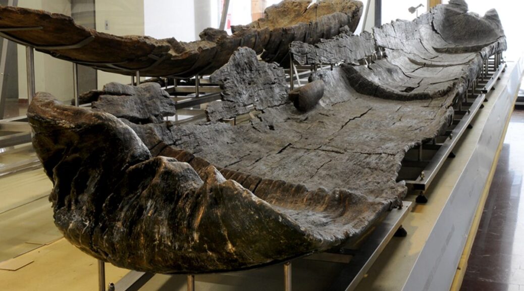
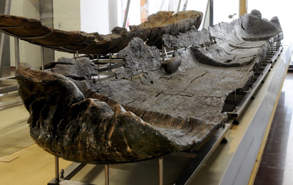
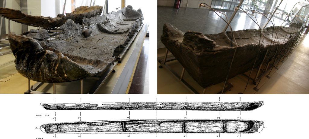
7,000-Year-Old Canoes Reveal Early Development of Nautical Technology in Mediterranean
The discovery of five “technologically sophisticated” canoes in Italy has revealed that Neolithic people were navigating the Mediterranean more than 7,000 years ago. The canoes date from between 5700 BC and 5100 BC and are the oldest in the region.
In research published in the journal PLOS ONE, archaeologists describe the discovery, at the Neolithic (Late Stone Age) lakeshore village of La Marmotta, about 30 km northwest of central Rome.
The quality and complexity of these prehistoric vessels suggest that several significant advances in sailing occurred during the late Stone Age, paving the way for the spread of the ancient world’s most important civilizations.
The authors note that the spread of Neolithic culture through Europe was chiefly carried out along the shores of the Mediterranean.
“Many of the most important civilisations in Europe originated on the shores of the Mediterranean Sea,” they write. “Phoenicians, Greeks, Romans and Carthaginians plied that practically enclosed sea to move rapidly along its coasts and between its islands.”
The writers say Neolithic communities occupied the whole Mediterranean between 9,500 and 9,000 years ago. They reached the Atlantic coast of Portugal by about 5400 BCE.
“It is clear that the Mediterranean Sea must have often been used for travel, as boats allowed rapid movements of population, contacts and exchange of goods,” the authors say.
It’s well known that maritime trade links existed in the Mediterranean during the Neolithic, although until now it was unclear how adept these early mariners were at handling the waves.
Navigating through this uncertainty, the authors of a new study have analyzed five dug-out canoes that were discovered at a 7,000-year-old settlement that now lies at the bottom of an Italian lake.
Canoe Marmotta 1. On display in the Museo delle Civiltà in Rome.
In this study, Juan F. Gibaja and colleagues provide new insights into the history of seafaring technology through analysis of canoes at the Neolithic lakeshore village of La Marmotta, near Rome, Italy.
Excavation at this site has recovered five canoes built from hollowed-out trees (dugout canoes) dating between 5700 and 5100 BC. Analysis of these boats reveals that they are built from four different types of wood, unusual among similar sites, and that they include advanced construction techniques such as transverse reinforcements.
One canoe is also associated with three T-shaped wooden objects, each with a series of holes that were likely used to fasten ropes tied to sails or other nautical elements.
These features, along with previous reconstruction experiments, indicate these were seaworthy vessels, a conclusion supported by the presence at the site of stone tools linked to nearby islands.
“These canoes are exceptional examples of prehistoric boats whose construction required a detailed understanding of structural design and wood properties in addition to well-organized specialized labor,” the researchers said.
Recent nautical technologies and these canoes share similarities, bolstering the theory that the early Neolithic saw many significant advancements in sailing. The authors suggest there may be more boats preserved near La Marmotta, a potential avenue for future research.
“Direct dating of Neolithic canoes from La Marmotta reveals them to be the oldest in the Mediterranean, offering invaluable insights into Neolithic navigation,” the authors add.