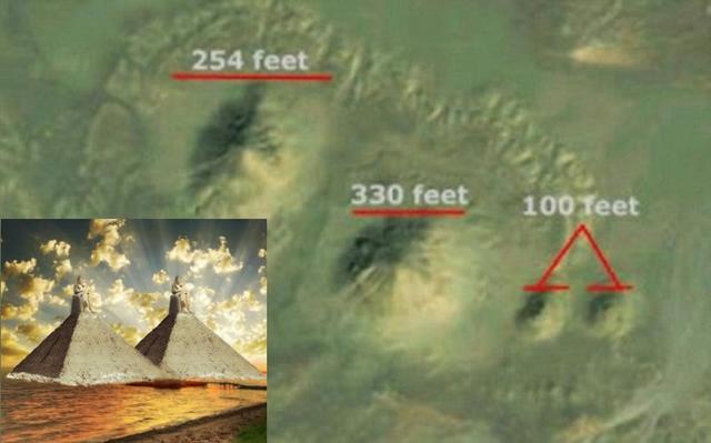
Archaeologists discover 35 burial chambers in the Sudan desert with fascinating links to Ancient Egypt
Archaeologists excavating a site in Sudan have discovered 35 pyramids revealing fascinating links between the bygone Kingdom of Kush that once existed there and ancient Egypt.
The pyramids, which date back around 2,000 years, are smaller than most Egyptian examples with the largest being 22 feet in width and the smallest, likely constructed for the burial of a child, being just 30 inches.
The site in Sedeinga, northern Sudan, was part of the ancient kingdom of Kush which shared a border with Egypt and, later on, the Roman Empire.
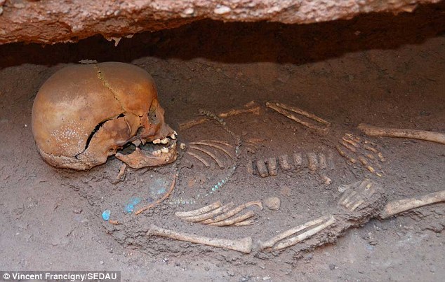
Discovery: The skeleton of a child buried with necklaces around its neck was unearthed amid a complex of 35 pyramids discovered in Sudan
Find: Some of the pyramids discovered in the dig in Sedeinga in northern Sudan. Unusually some had a circle built inside them with cross-braces connecting the circle to the corners of the pyramid
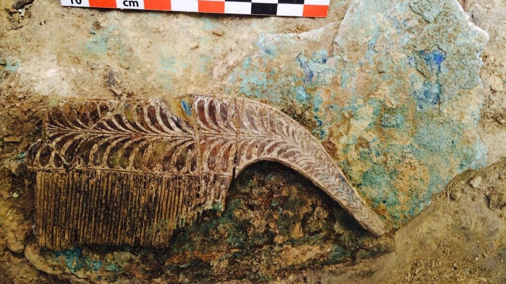
Treasures: An amulet of the Egyptian god Bes who was often associated with children and pregnant mothers (left) and archaeologist Vincent Francigny shows with a steal, a stone slab used to keep records (right)
One factor that has surprised the team was how densely concentrated the pyramids were. In a single area of 5,381 square feet, roughly the size of a basketball court, they found 13 pyramids.
Sadly the condition of the pyramids has suffered from the presence of a camel caravan route and the long passage of time and none of the top sections remains intact.
Capstones, depicting either a bird or a lotus flower on top of a solar orb, who have originally been placed at the top of the pyramids. Graves were discovered beside the pyramids in tomb chambers which were often found to have held more than one body.
Packed: One feature that surprised the team was how densely concentrated the pyramids were. In a single area of 5,381 square feet, roughly the size of a basketball court, they found 13 pyramids
Treasures: An offering table discovered at the site inscribed with ancient Meroitic writing (left) and a capstone which would have sat on the top of a pyramids shaped like a lotus flower above a solar orb (right)
Sadly these graves had all been plundered, possibly many hundreds of years ago, however, the archaeologists did find skeletal remains and some artefacts.
The archaeological team believes building of pyramids at Sedeinga continued for centuries and was strongly influenced by Egyptian funerary architecture.
Vincent Francigny, a research associate with the American Museum of Natural History in New York, told LiveScience: ‘The density of the pyramids is huge.
‘Because it lasted for hundreds of years they built more, more, more pyramids and after centuries they started to fill all the spaces that were still available in the necropolis.
‘They reached a point where it was so filled with people and graves that they had to reuse the oldest one.’
Some of the pyramids were found to have been built with cross-braces connecting the corners to an inner circle. Interestingly only one pyramid outside of Sedeinga is known to have been built in this way.
Mr Francigny believes that when pyramid building came into fashion at Sedeinga it could have been combined with a local circle-building tradition called tumulus construction, resulting in pyramids with circles within them.
He added: ‘What we found this year is very intriguing. A grave of a child and it was covered by only a kind of circle, almost complete, of brick.’
A copper alloy bowl was found in the tomb holding this skeleton (left).Sedeinga, in Sudan, sits near the River Nile which flows up into Egypt (right)
Among the artefacts discovered were depictions of Egyptian gods including Bes who is associated with children and pregnant mothers. One of the most interesting finds was an offering table depicting the jackal-headed god Anubis and a goddess believed to be Isis.
A dedication to a woman named ‘Aba-la,’ which researchers believe may be a nickname for ‘grandmother,’ was inscribed with ancient Meroitic writing – a script derived from Egyptian hieroglyphs.
Archaeologists Diving Under a 2,300-Year-Old Pyramid Find Ancient Treasure
Somewhere Below the surface of the kiddie-pool sized patch of brown water is the entrance to the 2,300-year-old tomb of a pharaoh named Nastasen. If I crane my neck back far enough, I can just make out the eastern flank of his pyramid rising nearly three stories above me.
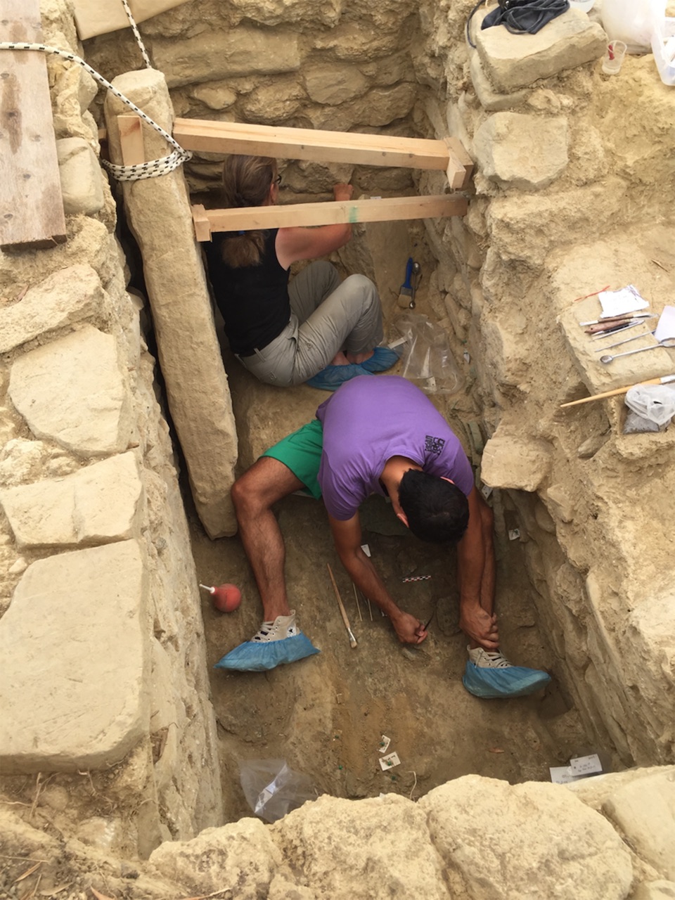
In order to access the tomb of pharaoh Nastasen, archaeologists had to excavate the processional staircase that leads to the burial chambers deep below his pyramid at Nuri.
It’s a sweltering morning in the desert of northern Sudan, the land of Nubia in the time of the pharaohs. Sweat drips into the dive mask hung around my neck as I negotiate my way down a narrow, ancient staircase cut deep into the bedrock. Waterproof flashlights clank from each wrist, and a 20-pound weight belt is slung commando-style across my chest. An emergency container of air, no bigger than a can of hairspray, is secured uncomfortably in the small of my back.
At the bottom of the stairs, archaeologist and National Geographic grantee Pearce Paul Creasman are standing chest-deep in the muddy water. “It’s really deep today,” he warns. “There’s not going to be any headroom in the first chamber.”
Creasman and I both trained as underwater archaeologists, so when I heard that he had the grant to explore submerged ancient tombs, I gave him a call and asked to tag along. Just a few weeks before I arrived, he entered Nastasen’s tomb for the first time, swimming through the first chamber, then a second, then into a third and final room, where, beneath several feet of water, he saw what looked like a royal sarcophagus. The stone coffin appeared to be unopened and undisturbed. Now, Creasman disappears into the water and resurfaces with a steel grate used to seal the tomb entrance. It looks no bigger than a large television set.
“This is how big the chute is,” he announces. “That’s your only space to get in and out of the tomb.” Back-mounted scuba tanks are too unwieldy in such tight confines, so we clip into 150-foot-long hoses that will supply us with air from a noisy, gasoline-fed pump.
“I’ll go first and pull my hose in,” Creasman says. “If I don’t see you in five minutes, I’ll come to find you.”
I nod and turn back to look up the ancient staircase, where Fakhri Hassan Abdallah, an inspector with Sudan’s National Corporation for Antiquities and Museums, stands silhouetted against the rising sun. He gives me a thumbs up and smiles. I shove the diving regulator into my mouth. It’s time to go pyramid diving.
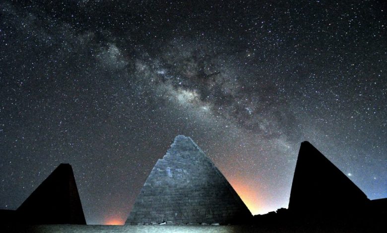
The pyramids of Nuri
Nastasen’s watery tomb is located at the ancient site of Nuri, which sprawls across more than 170 acres of sand near the east bank of the Nile River in northern Sudan. Seen from the sky, its most commanding feature is an arc of some 20 pyramids built between 650 B.C. and 300 B.C. that appear strung together like gems on a delicate necklace.
Local excavation helper at the entrance to a pyramid in Sudan below the groundwater table laying a compressed air line for diving archaeologists. Shutterstock.
These pyramids mark the burials of Kushite royals, the “black pharaohs” who operated as vassals on the gold-rich southern edges of the Egyptian empire, but who emerged as a force of their own during the political chaos that followed the demise of the New Kingdom. From about 760 B.C. to 650 B.C., five Kushite pharaohs ruled all of Egypt from Nubia to the Mediterranean Sea, embarking on ambitious building programs up and down the Nile and reviving the religious practices of a much earlier Egyptian empire—including the construction of pyramids, which they buried their kings under.
The largest and oldest pyramid at Nuri belongs to its most famous resident: the pharaoh Taharqa, a Kushite king who in the seventh century B.C. rallied his troops to the northern edges of his empire to defend Jerusalem from the Assyrians, earning him a mention in the Old Testament. George Reisner, a Harvard Egyptologist, visited Nuri a century ago to excavate the burial chambers beneath Taharqa’s massive pyramid.
Reisner’s team also mapped Nuri’s funerary monuments, which include more than 80 royal Kushite burials—roughly a quarter of which are topped with their sandstone pyramids. His field notes show that many of the tombs he encountered were already inundated with groundwater percolating from the nearby Nile, making traditional dirt excavation unsafe or impossible.
Reisner never published the results of his work (an associate cobbled what little was documented into a report published in 1955), and for almost a century Nuri was ignored. The Harvard archaeologist had offhandedly—and inaccurately—dismissed the Kushite kings as racially inferior and their accomplishments as an inheritance of older Egyptian traditions.
Then, in 1922, the discovery of Tutankhamun’s tomb shifted the public’s attention to the Valley of the Kings, nearly 500 miles up the Nile in Luxor. In the decades that followed, Nuri seemed too big and challenging a site to tackle. Many of its tombs were likely underwater, and no one had ever before attempted underwater archaeology in Sudan. Besides, northern Sudan—ancient Nubia—had plenty of other stunning sites to keep archaeologists busy for years to come.
Watery tombs
Pearce Paul Creasman first visited Nuri in 2018. An unusual hybrid of Egyptologist and underwater archaeologist (as well as an associate professor in the dendrochronology laboratory at the University of Arizona), Creasman saw a rare opportunity to explore the watery tombs that Reisner was unable to tackle a century ago.
Funded in part by a grant from the National Geographic Society, Creasman zeroed in on the pyramid of Nastasen, a minor pharaoh who ruled Kush from 335 B.C. to 315 B.C. Because he was the last king buried at Nuri, his pyramid was built on the worst piece of real estate in the lowest elevations of the royal necropolis. If Reisner’s reports about the flooded tombs were true, Creasman reasoned, an exploration of pharaoh Nastasen’s final resting place would be the best way to gauge how inundated these monuments might be in the 21st century.
According to Reisner’s century-old field notes, his team located and excavated the rock-hewn stairwell that led down to the burial chambers deep beneath Nastasen’s pyramid. One of Reisner’s workers entered the tomb and, likely unnerved by the knee-deep water, hastily made his way to the third and final chamber. There he dug a small pit in the corner and collected a handful of shabtis—small magical figurines tasked with tending to the deceased’s needs in the afterlife. The research team left Nuri, and over the decades Nastasen’s tomb, and the staircase leading to it, were again buried under the desert sands.
Creasman’s team spent the 2018 field season and part of the 2019 season digging out the staircase. They reached the opening of the tomb this January and discovered that the entrance was now completely underwater, most likely due to rising groundwater caused by natural and human-induced climate change, intensive agriculture near the site, and the construction of modern dams along the Nile.
Tantalizing clues
By the time I arrive at Nuri, Creasman has reinforced the narrow tomb opening with a steel chute to prevent a rock collapse that would trap divers in the chambers beneath the pyramid. I pull myself through the chute and into the first chamber. As Creasman had warned, the water reaches to the ceiling. Every movement kicks up a cloud of ultra-fine sediment that makes it almost impossible to see what’s directly in front of me.
I feel my way around the bus-sized chamber, swimming in circles until I eventually surface in the second chamber. There, the ceiling has collapsed, creating space for a large air pocket. I find Creasman hoisting bags of gear onto a pile of dry rubble and placing flashlights into plastic jerry cans that gently bob in the water and illuminate the darkness. Empty Red Bull cans serve as floats for a safety line that runs from the back of the tomb to the entrance.
Swimming through a low, rounded, rock-cut doorway, we enter the third chamber. The stone sarcophagus is dimly visible below us—a thrilling sight—and we spot the pit that was hastily dug by Reisner’s nervous worker a century ago. At this early phase of the project, Creasman’s objectives are to demonstrate the safety of the air-supply system, gather basic measurements, and thoroughly excavate “Reisner’s pit” to see what was overlooked. Peering inside the stone coffin will have to wait until next year.
But there are tantalizing clues that the rising groundwater kept grave robbers from looting Nastasen’s tomb. As we excavate Reisner’s pit—filling plastic buckets with sediment, swimming them out into the air-filled second chamber, dumping the sediment onto a screen and sifting for artefacts—we discover paper-thin foils of pure gold that likely once covered precious figurines that long ago dissolved in the water. Those gilded figurines would have been easy pickings for looters, and their remains are a sure sign that Nastasen’s tomb has been essentially untouched.
On our final dive, Creasman and I float silently in water in the back chamber of the tomb, hovering above what may very well be Nastasen’s undisturbed sarcophagus. We talk about the team’s goal for 2020: to excavate the pharaoh’s 2,300-year-old submerged royal burial chambers. It’s an audacious aim and a huge logistical challenge, but Creasman is optimistic.
“I think we finally have the technology to be able to tell the story of Nuri, to fill in the blanks of what happened here,” he says. “It’s a remarkable point in history that so few know about. It’s a story that deserves to be told.”
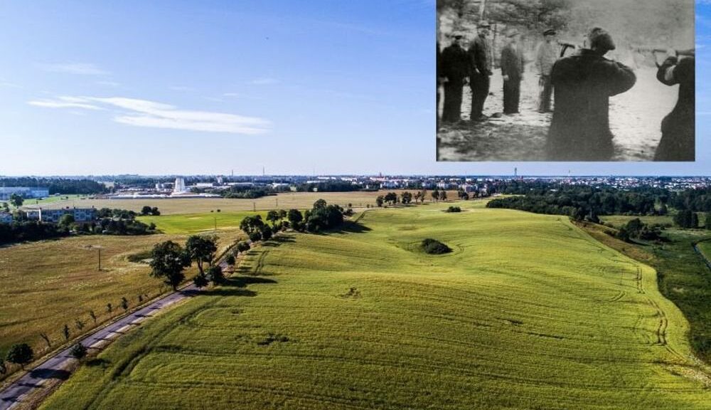
World War II Execution Site Investigated in Poland
Dawid Kobiałka of the Polish Academy of Sciences, with the assistance of an 88-year-old eyewitness, has found personal belongings, bullets, and charred human bone, including fragments of skulls, teeth, femurs, and a vertebra, just under the surface of the ground in an area of northern Poland dubbed “Death Valley,” according to a report by The First News.
On the outskirts of the town of Chojnice in northern Poland, where at least two mass killings took place at the hands of German death squads in 1939 and early 1945, at a site named ‘Death Valley’ the harrowing discovery was made. Dr Dawid Kobialka, from the Polish Academy of Sciences Institute of Archeology and Ethnology, who made the horrible discovery told TFN: “The bones and bullets are linked with the massacre of the second half of January 1945.
The crime was committed by the Gestapo and members of the German police, according to historical records. The bullets and shells came from the pistols of the Walther PPK and P08 Parabellum, indicating that the victims were executed at close range.” He added: “We found fragments of, among others, skulls, teeth, femurs, a thoracic vertebra. The bones lie just under the ground for one centimetre or two. To see the remains, it was enough to put a shovel in the ground once.
Dawid Kobialka from the Institute of Archaeology and Ethnology of the Polish Academy of Sciences said the bones were discovered one centimetre below the surface.
“There were more burnt human bones than sand.
“Most of the bones are actually ashes because of the temperature of the cremations. That is why the gasoline was used.” Eye-witness Jan Grunt said gasoline barrels were at Death Valley when the Germans left the site.
He said: “The shootings from pistols were heard almost all night. […]. The bodies were dowsed by gasoline and later burned. Three gasoline barrels that still lie in Death Valley confirm it. The fire was discernible for three days and nights at the Death Valley”. Another eye-witness Kazimierz Janikowski who is now 88 but was 13 at the time of the massacre and helped the researchers locate the site said: “We were going there [to Death Valley] because we were curious about what was happening.
“I was searching there and found [burned human] bones.
“I still see those 200-litre gasoline barrels. There was stench over town when the bodies were burned.”
Kobialka added that “marks of gasoline are preserved on fragments of wood discovered during the research.” The researchers also discovered humbling personal belongings the victims had on them when they were killed. One photo shows a battered wristwatch, another a spoon and plate. Yet another photo shows the fragment of a woman’s broach, confirming testimonies that both men and women were slaughtered.
Named Death Valley by locals, the area covers around 1.5km. Towards the end of the war, Gestapo officers shot dead around 600 prisoners in the ‘valley’ before setting their corpses on fire.
Researchers also discovered the personal remains of victims including a battered wristwatch.
Kobialka said: “There were several columns of people and they went in different directions. One of them was herded to Chojnice and murdered in Death Valley.
“The townspeople saw a glow of light at night on the outskirts of the city in the Valley of Death, and a terrible smell of burning went over the city.
“The most probable version of events is that they were Gestapo prisoners from the prison in Bydgoszcz.
“There, among others, were detained members of the Polish resistance who were captured at the turn of 1944-1945.”
He added: “In materials, we found in one document, there is an annotation that in Death Valley, then it was called Ostrówek, about 600 people were murdered and burned.”
The Chojnice killing fields lie just 50 miles north of the town of Bydgoszcz where the Germans carried out brutal repression following Hitler’s invasion of Poland in September 1939.
By the end of the war, it is estimated that around 36,350 civilians had been ‘liquidated’ by German forces in Bydgoszcz and the surrounding areas.
Kobialka said: “When the Red Army was coming from the south in January 1945, the Germans organised the evacuation of the prison.
“A few columns of prisoners were made, with some of them going to the west.
“One of them went to Chojnice under the supervision of Gestapo guards.
“The guards, according to one of the witnesses, organised the massacre.”
Earlier this year, the Institute uncovered remains from the 1939 massacre where in the early stages of WWII, German SS shot dead more than 500 locals as part of their ‘action against the intelligentsia’ who the Third Reich considered ‘dangerous’. In charge of operations was Heinrich Mocek, a sadistic Nazi officer who between October 1939 and January 1940 ordered extensive exterminations across the whole region as part of the Nazis’ Polish Intelligentsia Action, which saw around 30,000-40,000 Poles living in the Pomerania region murdered.
He was later convicted for a string of atrocities and sentenced to life imprisonment in 1965 by a West German court. But by the time the Red Army arrived he had fled Poland, leaving the question of who ordered and carried out the 1945 massacre unanswered.
Kobialka said: “The massacre in 1939 is relatively well-known. We know some of the victims, we know some of the murderers, we know some of the witnesses.
“But the massacre in January 1945 is a mystery. We found burned human bones close to the meadow.
“So, Death Valley embodies different locations near Chojnice that were the theatre of mass executions during the Second World War.
“We are still looking for historical records that will shed light on the subject.”
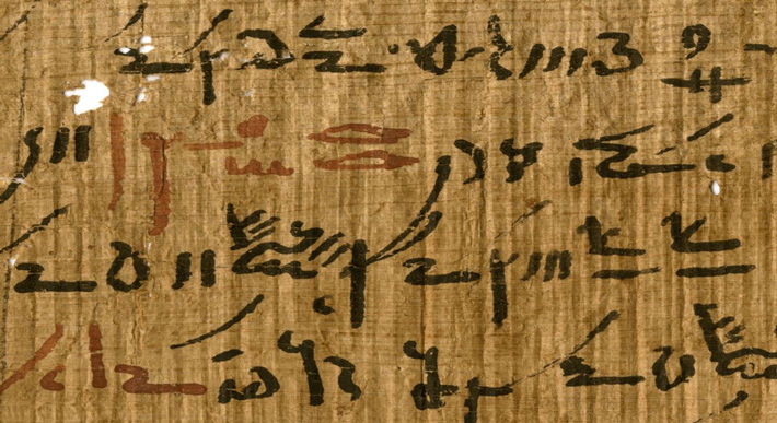
Scientists Analyze Ancient Egyptian Ink containing lead were likely used as drier on ancient Egyptian papyri
Cosmos Magazine reports that a team of chemists, physicists, and Egyptologists from the University of Copenhagen and the European Synchrotron Radiation Facility used advanced X-ray microscopy equipment to analyze the chemical composition of the ink markings found on papyrus fragments from Egypt’s ancient Tebtunis temple library.
Detail of a medical treatise from the Tebtunis temple library.
The studies, published in the Journal PNAS, not only illuminate how writing practices developed in Egypt and around the Mediterranean, it could help with the conservation of many famous manuscripts.
In this study, the focus was on a dozen papyrus fragments from the only large-scale institutional library known to have survived from ancient Egypt: the Tebtunis temple library.
And the team of chemists, physicists and Egyptologists called in the big guns, using the advanced X-ray microscopy equipment at the European Synchrotron Radiation Facility (ESRF) in Grenoble to examine them.
The work was led by the ESRF and the University of Copenhagen in Denmark.
They combined several synchrotron techniques to probe the chemical composition from the millimetre to the sub-micrometre scale to provide information not only on the elemental but also on the molecular and structural composition of the inks.
They concluded that the lead was used as a dryer because they did not find any other type of lead, such as lead white or minimum, which should be present if the lead was used as a pigment.
This also suggests that the ink had quite a complex recipe and “could not be made by just anyone”, says Egyptologist Thomas Christiansen from the University of Copenhagen, co-corresponding author of a paper in.
“Judging from the amount of raw materials needed to supply a temple library like the one in Tebtunis, we propose that the priests must have acquired them or overseen their production at specialised workshops much like the Master Painters from the Renaissance,” he says.
The ancient Egyptians have been using inks for writing since at least 3200 BCE, with black used for the primary body of text and red to highlight headings and keywords.
The researchers discovered that red pigment is present as coarse particles, while the lead compounds are diffused into papyrus cells, at the micrometre scale, wrapping the cell walls, and creating, at the letter scale, a coffee-ring effect around the iron particles, as if the letters were outlined.
“We think that lead must have been present in a finely ground and maybe in a soluble state and that when applied, big particles stayed in place, whilst the smaller ones diffused around them”, says co-corresponding author Marine Cotte, from the ESRF.
Ruins of the city Tebtunis, discovered in the 1930s. Credit: Kim Ryholt, University of Copenhagen.
Mysterious Ancient Structures Hidden Under The Sand In The Sahara Desert
Hundreds of stone structures dating back thousands of years have been discovered in Western Sahara, a territory in Africa little explored by archaeologists.
The structures seem to come in all sizes and shapes, and archaeologists aren’t sure what many of then were used for or when they were created, archaeologists report in the book “The Archaeology of Western Sahara: A Synthesis of Fieldwork, 2002 to 2009” (Oxbow Books, 2018).
About 75 per cent of the Western Saharan territory, including most of the coastline, is controlled by Morocco, while 25 per cent is controlled by the Sahrawi Arab Democratic Republic. Before 1991, the two governments were in a state of war.
The structures come in various shapes and sizes, including one that curves off into the horizon (shown here).
Between 2002 and 2009, archaeologists worked in the field surveying the landscape and doing a small amount of excavation in the part of Western Sahara that is controlled by the Sahrawi Arab Democratic Republic. They also investigated satellite images on Google Earth, they wrote in the book.
“Due to its history of conflict, detailed archaeological and palaeoenvironmental research in Western Sahara has been extremely limited,” wrote Joanne Clarke, a senior lecturer at the University of East Anglia, and Nick Brooks, an independent researcher.
“The archaeological map of Western Sahara remains literally and figuratively almost blank as far as the wider international archaeological research community is concerned, particularly away from the Atlantic coast,” wrote Clarke and Brooks, noting that people living in the area know of the stone structures, and some work has been done by Spanish researchers on rock art in Western Sahara.
Mysterious structures
The stone structures are designed in a wide variety of ways. Some are shaped like crescents, others form circles, some are in straight lines, some in rectangular shapes that look like a platform; some structures consist of rocks that have been piled up into a heap.
And some of the structures use a combination of these designs. For instance, one structure has a mix of straight lines, stone circles, a platform and rock piles that altogether form a complex about 2,066 feet (630 meters) long, the archaeologists noted in the book.
Here, a type of stone structure known as a “dolmen.”
Though the archaeologists are unsure of the purpose of many of the structures, they said some of them may mark the location of graves.
Little excavation has been done on the structures, and archaeologists have found few artefacts that can be dated using a radiocarbon method. Among the few excavated sites are two “tumuli” (heaps of rock) that contain human burials dating back around 1,500 years.
Research suggests that Western Sahara was once a wetter place that could sustain more animal life than it does today.
Archaeologists documented rock art showing images of cattle, giraffe, oryx and Barbary sheep while environmental researchers found evidence for lakes and other water sources that dried up thousands of years ago.
Security problems
At present, security problems in the region mean that fieldwork has stopped, Clarke and Brooks told Live Science.
The terrorist group al-Qaeda in the Islamic Maghreb operates in the desert regions near Western Sahara, and in 2013 they kidnapped two Spanish aid workers at a refugee camp in Tindouf, Algeria, just across the border from Western Sahara.
While the Sahrawi people and the Sahrawi Arab Democratic Republic strongly oppose the terrorist group, it’s extremely difficult for authorities to effectively patrol the vast desert areas where the stone structures are located, Clarke and Brooks said.
This means archaeologists can’t work there safely right now. This problem is not unique to Western Sahara, as the security risks posed by terrorist and extremist groups in the region mean that archaeologists can’t work in much of North Africa right now, they said.
Archaeologists Discover 3,500-Year-Old “Griffin Warrior” Tomb Full of Treasures
Jack Davis and Sharon Stocker, archaeologists in UC’s classics department, found the two beehive-shaped tombs in Pylos, Greece, last year while investigating the area around the grave of an individual they have called the “Griffin Warrior,” a Greek man whose final resting place they discovered nearby in 2015.
Like the Griffin Warrior’s tomb, the princely tombs overlooking the Mediterranean Sea also contained a wealth of cultural artefacts and delicate jewellery that could help historians fill in gaps in our knowledge of early Greek civilization.
The warrior was buried with a bronze sword, ivory combs, gold rings, and seal stones, gemstones carved with images depicting Minoan influences. Although the archaeologists don’t yet know where in Greece the griffin warrior was from, it’s clear from the wealth of objects found in his grave that he held a high station in society, and the particulars of the object are leading archaeologists to revise some accepted theories about Mycenaean Greece.
University of Cincinnati faculty and staff in the Griffin Warrior tomb
A detailed ivory comb found at the Pylos dig site
The warrior was buried with a bronze sword, ivory combs, gold rings, and seal stones, gemstones carved with images depicting Minoan influences. Although the archaeologists don’t yet know where in Greece the griffin warrior was from, it’s clear from the wealth of objects found in his grave that he held a high station in society, and the particulars of the object are leading archaeologists to revise some accepted theories about Mycenaean Greece.
The discovery was made near the southwest coast of Greece, close to the Palace of Nestor, which is part of the Pylos Regional Archaeological Project. The palace, named for King Nestor of Pylos in Homer’s The Illiad, is one of the best-preserved Bronze Age palaces on the Greek mainland, despite having been nearly destroyed by fire in 1200 BCE. Dr. Sharon Stocker and Dr. Jack W. Davis from the University of Cincinnati have been excavating at Pylos for the past 25 years.
The Palace of Nestor is an incredible source of archaeological information, though it has been more than 75 years since the last discovery of this magnitude: in 1939, Carl Blegen unearthed a number of tablets inscribed with Linear B script, writing that, borrowing heavily from the Minoan Linear A script, became the earliest known form of written Greek.
A gold ring found in the tomb at Pylos featuring Minoan Toreador imagery
Like the Linear B tablets, many of the objects found in the Griffin Warrior’s tomb display Minoan imagery, such as bulls and bull-leaping, a seemingly impossible athletic feat where a person jumps over a charging bull. These images of bull-leapers, also known as Toreadors, are common in Minoan culture and can be seen in many places, such as the stucco frescoes at the Palace of Knossos, The archaeologists have determined that the Griffin Warrior predates the Palace of Nestor, which might point to Mycenaean Greece flourishing earlier than previously thought in Pylos. Mycenaean Greece (1600–1100 BCE), the first advanced culture on the mainland, was a civilization in transition.
After mainland Greece invaded and occupied Minoan Crete around 1420 BCE, Greeks began to adapt, rather than destroy, the more sophisticated Minoan culture. Dr Davis believes that the presence of Minoan imagery on the Griffin Warrior’s artefacts “suggests that contact between Crete and Greece were very close… and that here in Pylos they… were in the process of incorporating Minoan ideas into their own ideology.”
The open shaft grave of the Griffin Warrior at Pylos
The archaeologists hope to do DNA testing on the Griffin Warrior’s teeth to try to determine his birthplace, which might help explain the meaning and purpose of the Minoan rings and stones in his tomb — e.g., whether these artefacts were personally important to him, aspects of Minoan culture that had been adopted by the Mycenaean people, or had been looted from Crete.
The Griffin Warrior’s discovery and further investigation into his birthplace might lead archaeologists to further reevaluate the history and timeline of Mycenaean Greek culture and its relation to Minoan Crete. This finding has revealed a wealth of new information, but work continues at the Pylos dig site to see how much more can be illuminated about Mycenaean Greece.
This 3.3-Million-Year-Old Hominin Toddler Was Kind of Like Us
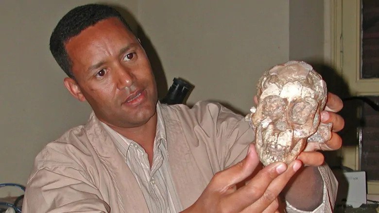
In a fragment of sandstone sticking from the soil in the sparkling flatlands of Northeast Ethiopia, a fossil fragment of the cheekbone has been detected. Zeresenay Alemseged almost instinctively realised that he had come across something important.
Zeresenay Alemseged holds the skull of a three-year-old Australopithecus afarensis at the National Museum of Ethiopia in Addis Ababa, Ethiopia. The discovery sheds light on the contentious debate about how well the species walked and climbed.
The skinbone brought a jaw, parts of a skull and eventually collar bones, shoulder blades, ribs and — perhaps most important — the most complete spinal column of any early human relative ever found.
Nearly 17 years later, the 3.3-million-year-old fossilized skeleton known as the “Dikika Baby” remains one of the most important discoveries in archaeological history, one that is filling in the timeline of human evolution.
“When you put all the bones together, you have over 60 per cent of a skeleton of a child dating back to 3.3 million years ago, which is more complete than the famous australopithecine fossil known as ‘Lucy,’ ” Alemseged, a 47-year-old professor of organismal biology and anatomy at the University of Chicago, told The Washington Post.
“We never had the chance to recover the face of Lucy, but the Dikika child is an almost complete skeleton, which gives you an impression of how children looked 3.3 million years ago.”
The fossil, also called “Selam” — “peace” in the Ethiopian Amharic language — has revealed numerous insights into our early human relatives. But Alemseged said one of the most startling findings comes from the toddler’s spine, which had an adaptation for walking upright that had not been seen in such an old skeleton.
The result, he said, is a creature whose upper body was apelike, but whose pelvis, legs and feet had familiar, humanlike adaptations.
“If you had a time machine and saw a group of these early human relatives, what you would have said right away is, ‘What is that chimpanzee doing walking on two legs?’ ” Alemseged said.
The Dikika foot is one part of a partial skeleton of a 3.32 million-year-old skeleton of an Australopithecus afarensis child
The findings, published in the Proceedings of the National Academy of Sciences, show for the first time the spinal column was humanlike in its numbering and segmentation. Though scientists know that even older species were bipedal, researchers said Selam’s fossilized vertebrae is the only hard evidence of bipedal adaptations in an ancient hominid spine.
“Yes, there were other bipedal species before, but what is making this unique is the preservation of the spine, which simply is unprecedented,” Alemseged said. “Not only is it exquisitely preserved, but it also tells us that the human-type of segmentation emerged at least 3.3 million years ago. Could there have been other species with a similar structure, yes, but we don’t know for sure?”
Human beings share many of the same spinal structures as other primates, but the human spine — which has more vertebrae in the lower back, for example — is adapted for efficient upright motion, such as walking and running on two feet.
Among the larger questions researchers like Alemseged are trying to answer include: When did our ancestors evolve the ability to be bipedal? When did we become more bipedal than arboreal, or tree-dwelling? And when did our ancestors abandon an arboreal lifestyle to become the runners and walkers that eventually populated Africa and then the world?
One of the significant barriers to answering those questions is that complete sets of vertebrae are rarely preserved in the fossil record.
“For many years we have known of fragmentary remains of early fossil species that suggest that the shift from rib-bearing, or thoracic, vertebrae to the lumbar, or lower back, vertebrae were positioned higher in the spinal column than in living humans, but we have not been able to determine how many vertebrae our early ancestors had,” said Carol Ward, a curator’s distinguished professor of pathology and anatomical sciences in the University of Missouri School of Medicine, and lead author on the study.
“Selam has provided us the first glimpse into how our early ancestors’ spines were organized.” Unpacking the intricacies of Selam’s spinal structure would not have been possible without the assistance of cutting-edge technology, researchers said.
After 13 years of using dental tools to painstakingly remove portions of the fossil from sandstone — which risked destroying the fossil — Alemseged packed up Selam in his suitcase and took the fossil from Ethiopia to the European Synchrotron Radiation Facility in Grenoble, France, in 2010. Alemseged and the research team spent nearly two weeks there using high-resolution imaging technology to visualize the bones.
Left block of images shows the 3.32 million-year-old foot from an Australopithecus afarensis toddler from different angles. The right block of images compares the child’s foot with the fossil remains of an adult Australopithecus foot (top).
The fossil had undergone a medical CT scan in 2002 in Nairobi, Alemseged said, but that scanner was unable to distinguish objects with the same density, meaning that penetrating bones encased in sandstone was impossible. Once in France, that was no longer a problem, and the results, he said, “were mind-blowing.”
“We were able to separate, virtually, the different elements of the vertebrae and were able to do it, of course, without any damage to the fossil,” Alemseged said. “We are now able to see this very detailed anatomy of the vertebrae of this exceptionally preserved fossil.”
The scans revealed that the child possessed the thoracic-to-lumbar joint transition found in other fossil human relatives, but they also showed that Selam had a smaller number of vertebrae and ribs than most apes have.
For researchers, the skeleton is a window into the transition between rib-bearing vertebrae and lower back vertebrae, which allowed our early human ancestors to extend at the waist and begin moving upright, eventually becoming highly efficient walkers and runners. Though he has been studying Selam for nearly two decades, Alemseged thinks the fossil has more secrets to share with the modern world.
“I don’t think she will stop surprising us as the analysis continues,” he said. “Science and tech are evolving so much that I’m sure in a few years we’ll be able to extract even more information that we’re not able to extract today.”
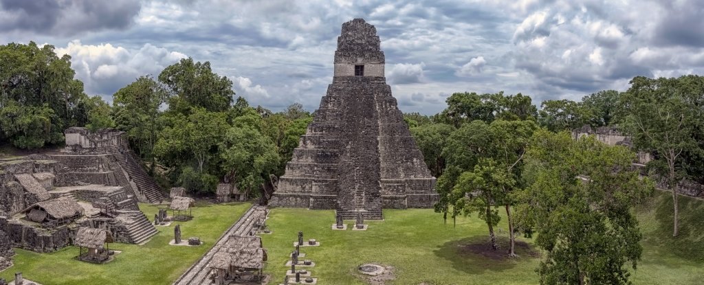
Impressive Water Purification System Found at Ancient Maya City
For fundamental human life, water is necessary. Yet polluted water can also spread lethal viruses that can kill whole communities. Safe, clean water offers humanity one of its best chances to thrive.
Many ancient cultures purified their rivers, including the Greeks, Egyptians and Romans. Water treatment methods are also mentioned in Sanskrit texts dating from 2,000 BCE. Now, archaeologists have also discovered the Mayan of South America – and their water filtration mechanism was amazingly effective.
In a reservoir in what was once the major Maya city of Tikal, the ruins of which crumble in a rainforest in present-day Guatemala, archaeologists have found zeolite and quartz – minerals that are not local to the area, and which are both effective at helping remove contaminants such as microbes, heavy metals, and nitrogen compounds from water.
So effective, in fact, that they are both used in water filtration systems today.
“What’s interesting is this system would still be effective today, and the Maya discovered it more than 2,000 years ago,” said anthropologist Kenneth Barnett Tankersley of the University of Cincinnati.
Zeolite, in particular, is interesting. It’s a natural crystalline compound of silicon and aluminium, linked via shared oxygen atoms to form an open crystal lattice. It has excellent absorption and ion exchange properties, which makes it very effective at filtering water.
But, although the ancient Greeks and Romans used it as a pozzolan – an ingredient for cement – in aquatic structures such as bridges and aqueducts, archaeologists thought that zeolite hadn’t been used for water filtration until around the beginning of the 20th century.
“The apparent zeolite filtration system at Tikal’s Corriental reservoir is the oldest known example of water purification in the Western Hemisphere,” the authors wrote, “and the oldest known use of zeolite for decontaminating drinking water in the world.”
The ability to have clean water was of deep importance to the Maya, and of great concern, particularly to Tikal. The city’s only water source was 10 reservoirs. Given the large population, and the highly variable climate that went through periods of seasonal drought, their drinking water was prone to contamination from both microbes and cinnabar, or mercury sulfide, a pigment the Maya used heavily.
It stands to reason that they had some means of keeping the water clean. So Tankersley and his team went to investigate. They studied three of the largest reservoirs in the ancient city, as well as a local sinkhole as a control for mineral composition.
The discovery was made in the Corriental reservoir, an important source of drinking water for the residents of Tikal, and one of the largest drinking water reservoirs in use by the Maya for over a thousand years. Mixed in among the sediment at the bottom of the reservoir, the team found what they were looking for: zeolite and coarse quartz sand.
The zeolite was found only in the Corriental reservoir. There’s no way it could have just happened to be there when the reservoir was dug.
In fact, the team believes that the mineral was quarried from a site some 30 kilometres (18 miles) northeast of Tikal. There, volcanic rock forms an aquifer known to produce exceptionally clear water. University of Cincinnati geographer Nicholas Dunning was familiar with the area after previously conducting fieldwork there.
“It was an exposed, weathered volcanic tuff of quartz grains and zeolite. It was bleeding water at a good rate,” Dunning said. “Workers refilled their water bottles with it. It was locally famous for how clean and sweet the water was.”
The team compared the Corriental quartz and zeolite from material taken from the aquifer and found that the two were a very close match. They also used radiocarbon dating to determine the age of the sediment and dated it to between 2,185 and 965 years ago.
It’s impossible to know exactly how the filtration system worked, but putting together the evidence, the team believes that it has a pretty good picture.
“The filtration system was likely held behind dry-laid stone walls with the zeolites and macrocrystalline sand-sized quartz crystals further constrained with woven petate (woven reed or palm fibre matting) or other perishable porous material positioned just upstream of, or within the reservoir ingresses, which were periodically ejected into the reservoir during flash floods caused by tropical cyclones,” the researchers wrote in their paper.
And it seems to have worked. Mercury deposits, likely from cinnabar contamination, had previously been found in several other Tikal reservoirs. Not a trace of it could be detected in Corriental.
“The ancient Maya lived in a tropical environment and had to be innovators. This is a remarkable innovation,” Tankersley said.
“A lot of people look at Native Americans in the Western Hemisphere as not having the same engineering or technological muscle of places like Greece, Rome, India, or China. But when it comes to water management, the Maya were millennia ahead.”