‘Lost’ 1,500-year-old Teotihuacan village discovered in the heart of Mexico City

‘Lost’ 1,500-year-old Teotihuacan village discovered in the heart of Mexico City

Archeologists have unearthed the lost remains of a Teotihuacan village, including human burials, in the heart of Mexico City.

'Lost' 1,500-year-old Teotihuacan village discovered in the heart of Mexico City
Archeologists discovered three human burials in the remains of the lost village.

Ceramics found scattered around the site, which is located 1.5 miles (2.4 kilometers) northwest of the city’s historical center, indicate the village dates from around A.D. 450 to 650 and may have housed a community of artisans and craftspeople.

“The finding was surprising,” said Juan Carlos Campos-Varela, an archaeologist at Mexico’s National Institute of History and Anthropology (INAH) Directorate of Archeological Salvage, who co-led the dig.

“It shows that 1,300 years ago, the islets inside Lake Texcoco, on which Mexico City was founded [after the lake was drained], already supported a permanent population that took advantage of the resources of the lake environment,” he told Live Science in an email.

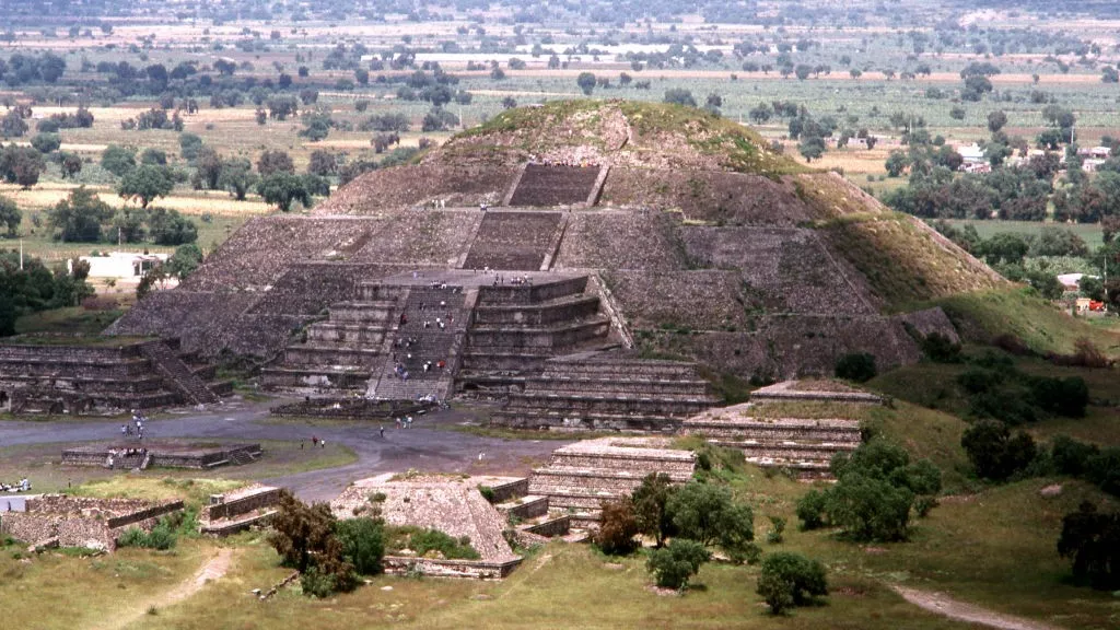
The newly excavated settlement may have formed during the “ruralization” of Teotihuacan, an ancient metropolis that flourished in the highlands of what is now central Mexico between A.D. 100 and 650, Campos-Varela said.

The village is located 25 miles (40 km) southwest of Teotihuacan and may have been one of several small towns that supported themselves through subsistence farming and fishing as the ancient city reached its zenith.

These settlements maintained commercial ties to Teotihuacan, and the new discoveries shed light on the role these settlements played in the city’s supply network, Campos-Varela said.

“The discovery is rare because it occurred in a fully urbanized context where the possibility of finding archeological evidence associated with the Teotihuacan culture was very low,” he added.

Gifted craftspeople

Archeologist Francisco González Rul discovered the first clues to this village’s existence in the 1960s, during construction works in the Mexican capital. Based on the ceramics he unearthed, González Rul suggested at the time that the inhabitants were self-reliant fishers and gatherers. The new excavations confirmed this.

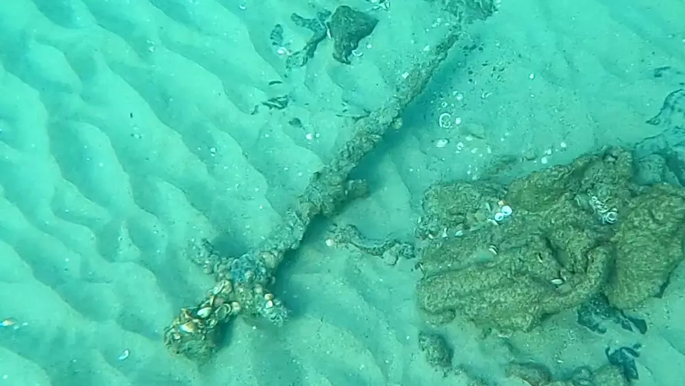
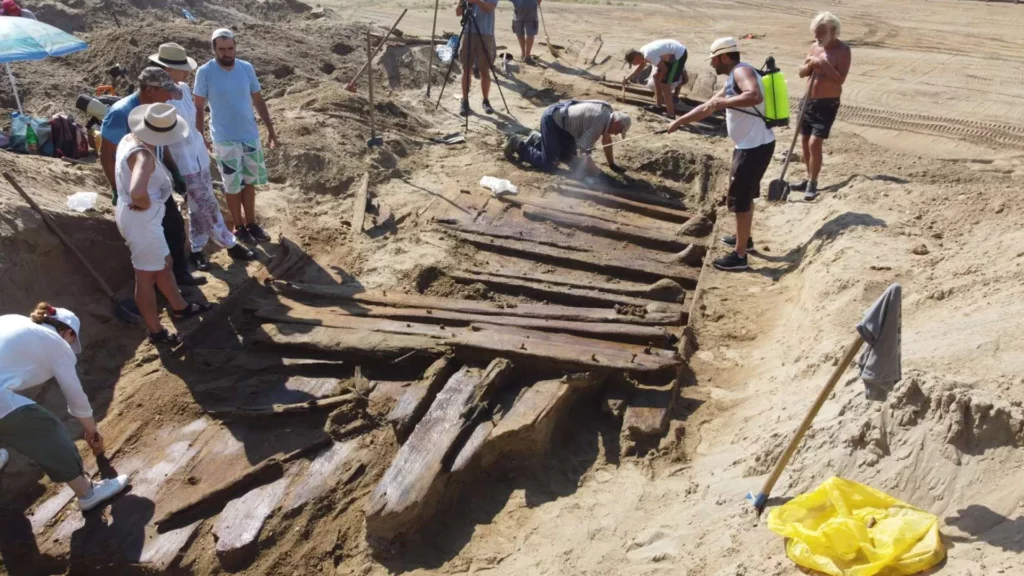
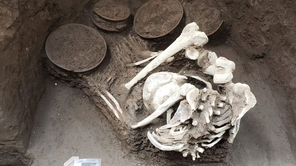
Several previously unseen architectural structures—including post holes, flooring, channels, and an artesian well — as well as ceramics have come to light. The excavation also unearthed three human burials containing the skeletons of two adults and a child.

Teotihuacan was an ancient metropolis that flourished in the highlands of what is now central Mexico.

Teotihuacan ceramics are categorized into phases, according to a 2016 study in the journal PLOS One. The newfound ceramics displayed features that correspond to the Xolalpan (A.D. 350 to 550) and Metepec (A.D. 550 to 600) phases in the 2016 study, which enabled the researchers to date the remains of the village and its inhabitants. 

The Teotihuacans were gifted artists and craftspeople, said Michael Smith, a professor of archeology and director of the Teotihuacan Research Laboratory at Arizona State University. “To decorate the walls of their houses and temples, the Teotihuacanos used the same fresco technique used by Michelangelo to paint the Sistine Chapel,” Smith told Live Science in an email. “They also used the fresco technique on ceramic vessels.”

The ceramics could reveal important information about trade with Teotihuacan through chemical analysis, Smith said. 

Archeologists have concluded the excavations and are now analyzing the discovered materials and bones. Much of Teotihuacan’s sprawling architecture remains buried, but the site is largely unaffected by modern construction and will eventually be unearthed in its entirety, Arizona State University said.

A 30-Foot-Long Hidden Corridor was discovered in the 4,500-year-old Great Pyramid of Giza!

A 30-Foot-Long Hidden Corridor was discovered in the 4,500-year-old Great Pyramid of Giza!

A 30-foot-long hidden corridor was discovered on March 2, 2023, in the Great Pyramid of Giza. This monument is the last standing Ancient Wonder of the World. This North Facing Corridor (NFC) is the first discovery uncovered on the monument’s north side.

The corridor is located above the ancient entrance of the pyramid, behind a chevron-shaped structure that is visible outside the pyramid. This fascinating discovery within the pyramid was made under the ScanPyramids project using muon tomography, a non-invasive technology.

The ScanPyramids Project – An Initiative to Uncover the Hidden Secrets in the Pyramids

https://twitter.com/Levandov_1/status/1631576731961180161?ref_src=twsrc%5Etfw%7Ctwcamp%5Etweetembed%7Ctwterm%5E1631576731961180161%7Ctwgr%5Ecfd612a67ea11b3a667f7a42bf2e0b00ff2baaf5%7Ctwcon%5Es1_&ref_url=https%3A%2F%2Funbelievable-facts.com%2F2023%2F03%2Fhidden-corridor-discovered-in-the-great-pyramid-of-giza.html

The Great Pyramid was constructed around 2560 BCE during the reign of Pharaoh Khufu. The height of the monumental tomb was around 146 meters when it was constructed. But it now stands at 139 meters with much of its limestone casing removed.

The pyramid consists of an elaborate system of passageways and chambers. However, not all of them have been uncovered yet.

In order to detect the presence of unknown voids and structures without excavating, the ScanPyramids project was launched in 2015. This Egyptian-international project is designed and led by Cairo University and the French HIP Institute (Heritage Innovation Preservation). The project combines several non-invasive and non-destructive techniques, such as 3D simulations, infrared thermography, muon tomography, and other reconstruction techniques, to scan the structure.

The 30-Foot Long Hidden Corridor Was Discovered Using Non-Invasive Technology.

Telescope installed inside the Great Pyramid of Giza.

As part of the ScanPyramids project, the most recent discovery is a 30-foot-long hidden corridor in the Great Pyramid of Giza. Egyptian antiquities officials confirmed its discovery on March 2, 2023.

The corridor was detected using muon tomography, a non-invasive technology that uses cosmic ray muons to generate three-dimensional images of objects. In order to retrieve images of what lies within, researchers inserted an endoscope into a tiny joint in the pyramid stones. However, no artifacts were visible in the captured images.

Mostafa Waziri, head of Egypt’s Supreme Council of Antiquities, said that the hidden corridor might have been constructed to redistribute the weight within the massive monument. In fact, in another part of the pyramid, there are five rooms atop the King’s Burial Chamber, which are thought to have been built to redistribute the weight of the massive structure. Waziri also added that they would continue scanning to figure out what is underneath the chamber at the end of the corridor.

Installing muon emulsion films.

Scientists also believe that structural innovations constructed by the Egyptian tomb builders were mostly for pragmatic reasons rather than storing any hidden treasure. For example, the discovered hidden corridor could be related to the construction of the chevron as a first test of the structure before it was used later, higher up in the pyramid. Therefore, there is little likelihood anything major or valuable will be found inside these chambers.

An article published in the Nature Communications journal said that the discovery of this hidden corridor could help in gaining knowledge about the structure and techniques used in the construction of the pyramid. In addition, it could also help in understanding the purpose of the gabled limestone structure that sits in front of the corridor.

Furthermore, Egyptian antiquities officials believe that this amazing discovery could serve as a catalyst for conducting further research in other mysterious inner chambers.

Other Extraordinary Discoveries of the ScanPyramids Project

The great pyramid of Giza.

The ScanPyramids project has led to many other astonishing discoveries in the past. In 2016, researchers discovered a void behind the north face of the Great Pyramid. Following this, in 2017, they discovered a bigger “plane-sized” void, around 98 feet long, above the Grand Gallery.

Thus, we can conclude that even though the tomb commissioned by Pharaoh Khufu has been explored for years together, there are many more mysteries yet to be unraveled.

Scientists plan to continue these non-invasive scans at the Great Pyramid of Giza to uncover more hidden secrets as part of the ScanPyramids project. They also plan to use sophisticated muon detectors to detect the presence of artifacts, if any

A Library Discovered Behind a Wall in the Sakya Monastery Has 84,000 Unread Manuscripts!

A Library Discovered Behind a Wall in the Sakya Monastery Has 84,000 Unread Manuscripts!

In 2003, an ancient library was discovered, hidden behind a wall inside the Buddhist Sakya Monastery. The Sakya Monastery stands in the Tibet Autonomous Region, in the Southwestern part of the People’s Republic of China. Located around 300 miles west of Lhasa, Tibet, Sakya remains one of the foremost centers for Tibetan Buddhism and learning.

With more than 80,000 untouched manuscripts, this library was safely tucked away behind a wall. Historians suggest that this was probably to protect it from Chinese Communist attacks.  This enlightening historical discovery can reveal a lot about the history of the region!

Let us unravel some truthful and not-so-truthful facts about the Sakya Library.

The Sakya Library, with 84,000 manuscripts, dates back 10,000 years – fact check.

A Library Discovered Behind a Wall in the Sakya Monastery Has 84,000 Unread Manuscripts!
The manuscripts at Sakya Library are stacked.
The manuscripts at Sakya Library.

Most social media posts and articles mention that the library has 84,000 manuscripts that contain 10,000 years of human history and secrets of ancient civilizations. Since then, many scholars and experts have come forward to clarify the claim.

They all believe that 10,000 years would predate the earliest recorded writing in human history. According to an editor and researcher for the Ancient History Encyclopedia, Joshua J. Mark, the oldest known written literature is the Epic Poem of Gilgamesh, the great Sumerian work that dates back to 2150 to 1400 BCE. This fact has also been corroborated by other experts and scholars who all agree that the oldest written work in human history was indeed invented in Mesopotamia by the Sumerians. That was around 5,500 years ago. Therefore, the 10,000 years claim is unlikely to be true.

(Left) Neo-Assyrian clay tablet. Epic of Gilgamesh, Tablet 11: Story of the Flood. Known as the “Flood Tablet.” (Right) Tablet V of the Epic of Gilgamesh.

The manuscripts, or paper on which these scrolls are written, are unlikely to be as old as 10,000 years. Ancient Egyptian scrolls on papyrus are around 5,000 years old. Also, the paper was first discovered in China only around 2,000 years ago.

The fact that this secret library contains 84,000 manuscripts was verified by a few news agencies. The Congressional-Executive Commission on China mentions on its website that there are 80,000 volumes in the collection of centuries-old texts at Sakya Monastery. Therefore, 84,000 manuscripts do not seem to be far-fetched, and this could very well be true.

The Sakya Library has a book that weighs 1,102 pounds.

Inside the Main Chanting Hall of the Sakya Monastery.

The Commission also mentions that the books are stacked in 200-foot-long and 30-foot-high racks in near complete darkness in a storage facility that is 250 feet from the monastery’s main hall, in a chamber behind the main altar. However, all these books were untouched and remained in one place for hundreds of years. Therefore, it will still take a lot of time for experts to go through all of them. But the work has started!

Most of the books in the Sakya Library are Buddhist scriptures. They are handwritten in Chinese, Tibetan, Mongolian, and Sanskrit. The books also include works of literature, astronomy, mathematics, art, agriculture, history, and philosophy. Interestingly, the Sakya Library is known to have a scripture that weighs more than 1,100 pounds.

The Tibetan Academy of Social Sciences (TASS), the leading organization responsible for all of the Tibetan Digital Library’s fieldwork in the Tibet Autonomous Region, examined the Sakya Library in 2003. TASS is still checking and categorizing the huge collection of books and palm-leaf manuscripts in the library. As of 2022, all the books are indexed, and more than 20% of books have already been digitized.

Historical accounts describe books written in gold letters, bound in iron.

Even before the new hidden library was discovered in 2003, Sakya Monastery always had a rich collection of scriptures. Sarat Chandra Das was an Indian Scholar of the Tibetan language and culture who journeyed to Tibet in 1879 and 1881. He writes in his account that there are volumes written in gold letters in the Sakya Library. Some manuscripts are six feet long and 18 inches in breadth. There are books with illuminated margins and also books bound in iron. Some are even adorned with images of a thousand Buddhas. Such fascinating, rich accounts of the Sakya Library make the place even more enigmatic. According to historians, these extraordinary manuscripts were made under the direct orders of emperor Kublai Khan and presented to the fifth leader of the Sakya School of Tibetan Buddhism, Phagpa Lama.

A Very Brief History of the Sakya Monastery

Sakya monastery, a pious place of worship, is a hidden treasure trove in the barren mountains. It is a seat of the Sakya sect of Tibetan Buddhism, situated in the Tibet Autonomous Region, around 78 miles west of Shigatse.

The northern part of the monastery, built in 1073 CE, was grand, with over 100 buildings. It was built by Khön Könchok Gyalpo, a Nyingmapa monk from the powerful Tsang family. He became the first Sakya. The southern monastery was founded in 1268 CE across the Zhongqu River, which separated the southern part from the northern one. It was colored red, white, and gray in honor of the three Buddhist Tulkas. But, most of this southern monastery was burned down in the 16th century and restored only in 1948.

After the Lhasa uprising in 1959, which intended to protect the 14th Dalai Lama from the Communist Party of China, most of the monks fled the monastery. However, during the Cultural Revolution in 1966, the northern monastery was totally destroyed. What remains now is a two-story hall overlooking the southern monastery. It is said that the Sakya Library was spared at the behest of Premier Zhou Enlai. It was rebuilt only in 2002.

Corridor with two rows of prayer wheels along the walls in Sakya Monastery, Tibet, China.

Today, most experts believe that the Sakya Library is the largest surviving account of the history of the Tibetan areas of China and therefore holds immense importance.

Who Craved the Giant Handprints in the White Mountain Petroglyphs, Wyoming?

Who Craved the Giant Handprints in the White Mountain Petroglyphs, Wyoming?

We are not in total darkness about how our ancient ancestors lived their lives thousands of years ago. One reason for this is that they etched their daily lives, including struggles, celebrations, fears, or rituals, on rocks, stones, and caves that we can see even today. These illustrations, like the White Mountain Petroglyphs, are like a historical legacy that silently tells us stories of their lives.

The White Mountain Petroglyphs are a powerful testimony to the lives of the Native American tribes who lived there between 200 and 1,000 years ago.

Apart from hundreds of carved figures in the area, there are giant handprints that look like someone has scooped a part of the mountain and let it solidify. These mysterious handprints are perhaps one of the most captivating things to see if you ever visit the remote White Mountains site.

Where can you find the White Mountain Petroglyphs? Who made them?

The White Mountains of Wyoming.

The White Mountain Petroglyph site in Wyoming’s Red Desert was once the home of Native American tribes. The site roughly starts ten miles north of Rock Springs. But to reach the White Mountains, where the petroglyphs are, one must drive 16 miles on a dirt road from the main site and walk a quarter mile on foot.

Petroglyphs (rock carvings) and pictographs (rock paintings) are the windows to the past, giving us almost a first-hand account of the lives of those who made them. Here, on the mountain face canvas, there are carvings and handprints that are the most tangible connections we have with the Great Basin Native Americans who lived there between 200 to 1,000 years ago. They include the Shoshone, Arapaho, and Ute tribes.

It is interesting to note that in other parts of the World, petroglyphs can be as old as 20,000 years. They started to diminish with the discovery and introduction of other forms of writing surfaces, different forms of art, and pictographs. But many cultures, like the Native Americans, continued to create them until contact was made with  Western culture, sometimes as late as the 18th or even the 19th century.

The petroglyphs have animals, symbols, and mysterious handprints.

The markings tell us a lot about the beliefs and culture of the people who lived here several hundred years ago and more. There are carvings in the White Mountains that look like bison and elk hunts. There are also buffalos and wild horses carved on the rock face. Apart from the animals, there are also various interesting geometric shapes and tiny footprints that embellish the rock face.

A Bison Carved on the Sandstone.

Though not much is known about these shapes or symbols, the local Native Americans consider them sacred. They feel connected to nature and feel positive when they visit the site.

According to a Native American elder, symbols are important and communal.  They feel the rocks are alive and connected to them. Some carvings also depict horses and warriors with swords. They tell us about their contact with European cultures.

White Mountain Petroglyphs.

But the most mysterious of all is the deep-set handprints that are somehow left within solid sandstone as if someone had mysteriously softened the rocks. These petroglyphs are important to understand the culture and beliefs of the people who made them.

How were the deep handprints in the White Mountain Petroglyphs site made?

Deep Handprints in the White Mountain Petroglyphs.

The handprints, deeply embedded in the sandstone, give an effect of mountain-scooping. According to historians, the handprints were created by the Easter Shoshone tribes between 1,000-1,800 CE. Thousands of people since then have continued to make the same motion with their hands across the soft sandstone. This, in turn, has created the effect of handprint carving deep into the rocks.

According to a website on Wyoming history, this was the birthing place for the Plains and Great Basin Tribes. The locals tell a fascinating story about how these handprints originated. Native women used to visit the White Mountains when they were giving birth. As their labor started and they had their contractions, their hands used to seek support on the mountain face and created deep handprints into the soft sandstone.

Standing against the rocks, they gave birth. Today, the site is considered sacred by  Native Americans, and visitors are urged to respect the site and not destroy any part of history through vandalism. Unfortunately, though, reckless damage to the site has already happened.

Could the White Mountain Natives melt stones?

White Mountain Petroglyph Site

The petroglyphs on the White Mountain are made of sandstone, a softer rock that gradually hardens with time. They were probably engraved with a harder object than the sandstone. Therefore, maybe melting stones was not necessary in this case.

But what about the handprints that look like they have been scooped out of the mountain? They are deep set in solid sandstone, giving an impression that, somehow, the ancients could soften the rocks like snow. Though these have not been studied much, experts believe the birthing story might have a logical explanation. These stones were soft, and years of pushing your hands into the mountains can make these handprints really deep and big.

Not just in the White Mountains but worldwide, there are similar examples of stone bending and carvings. Scientists and historians often discuss how ancient civilizations knew advanced mechanisms to melt or soften stones.

One interesting theory, based on the shaping of stones in Peru, is that the ancients knew a plant that could melt stones. Scientists also believe ancient cultures knew advanced science and used high temperatures to shape rocks. This unknown process vitrified the surface of the rocks, turning them glasslike, on which they carved. But the process remains a mystery.

The petroglyphs in the White Mountains have not been researched, or studied by anyone formally, yet. They remain elusive and hidden, getting only 12,000 visitors a year. Let us hope when visiting the site, the visitors respect the sacredness and tread lightly to preserve the petroglyphs for as long as possible.

The Hanging Pillar of Lepakshi Temple that Challenges Gravity

The Hanging Pillar of Lepakshi Temple that Challenges Gravity

Gravity, the powerful force that rules our world, seems rigid and invincible. Still, tucked away in southern India is a beautiful architectural marvel known as the “Hanging Pillar,” which is said to challenge this very force. Yes! You read that right.

It dates back to the 16th century. This remarkable monument is located within the Veerabhadra Temple in Lepakshi and is dedicated to Lord Shiva’s furious manifestation, Veerabhadra.

The temple is adorned with beautiful sculptures and paintings that grace almost every visible surface. It displays the distinguishing Vijayanagara-style architecture. The magnificence and historical importance of Lepakshi Temple makes it one of the most notable Vijayanagara temples, revered as a nationally conserved monument.

The temple is divided into three sections: the Garbhagriha (sanctum sanctorum), the Arda Mantapa (antechamber), and the Mukha Mantapa/Natya Mantapa/Ranga Mantapa (assembly hall).  Nonetheless, the Hanging Pillar, indeed, is a testament to architectural ingenuity.

Location and Historical Significance

Veerabhadra Temple, Lepakshi.

The Lepakshi Temple, also known as the “Veerbhadra Temple,” is located in the Lepakshi village of Anantapur District in the Indian state of Andhra Pradesh. It is an outstanding example of both engineering innovation and artistic skill. It has many components that add to its archaeological and aesthetic splendor, such as exquisitely carved statues of musicians and saints and those showing a sacred couple of deities –  Lord Shiva and Goddess Parvati. In addition to its architectural significance, the temple is highly revered since the Skanda Purana refers to it as a “divyakshetra,” a place of worship of Lord Shiva.

The Lepakshi Temple was built in the 1530s CE by two brothers named Virupanna Nayaka and Viranna. During King Achutaraya’s reign, both served as governors for the Vijayanagar Empire.  You can find many Kannada language (predominantly spoken in southwestern India) inscriptions here.

The origins of Lepakshi are shrouded in mythology and narratives. According to one legend, Jatayu, a vulture deity depicted in the epic Ramayana, fought Ravana fiercely to save Sita, Lord Rama’s wife. Jatayu bravely fought after being hurt before collapsing to the ground. While Lord Rama and his brother Lakshmana were searching for Sita, they found Jatayu battling for his life, holding his last breath. When he found Jatayu in such a helpless state, overcome with grief, Lord Rama said the words “Le Pakshi,” which means “rise, bird” in Telugu.

The complex contains several other temples besides the Veerabhadra Temple, which is under consideration for UNESCO’s world heritage list (tentative list.) These include the shrines of Hanumalinga, Raghunatha, Parvati, Ramalinga, and Papanasesvara. There are many other attractions in this area, in addition to the well-known Hanging Pillar.

Nandi, Lepakshi Temple.

The Monolithic Bull, called the Nandi, is another noteworthy feature of Lepakshi. This enormous bull (approximately 20-foot high and 30-foot long) sculpture was cut from a single granite rock.

The Naga Shiva Linga is another impressive piece of architecture. The structure’s seven-headed hooded serpent and lingam (a representation of Lord Shiva) together make for a stunning sight. Lepakshi provides a fascinating cultural and historical experience for sure.

Is the Hanging Pillar Actually a Miracle?

The Hanging Pillar of Lepakshi Temple that Challenges Gravity
Hanging Pillar.

The Hanging Pillar in Lepakshi, which is made of granite, is a spectacular phenomenon that draws a lot of attention. Among the temple’s 70 pillars, this one stands out because it is hanging without touching the ground. Owing to this, many visitors to the temple cannot resist passing a piece of cloth or paper beneath the bottom of the pillar to confirm its authenticity. 

The puzzle of how this pillar manages to remain hung without any support is still unexplained and remains a mystery. It adds an aura of intrigue and surprise to the temple, supported by around 70 pillars. The pillar is also engraved with beautiful carvings.

As per the local folklore, in India’s pre-independence era, a curious British engineer once tried to move the hanging pillar to figure out the source of its support. Realizing the importance of each pillar in safeguarding the balance of the whole structure, he wisely stopped, saving the structure from collapsing. Despite a slight displacement, the pillar stood still. This led to the displacement of the hanging pillar.

Another folktale talks of British engineers who wanted to make renovations and chose to remove the pillar. It was so perfectly fixed that they couldn’t move it. But they didn’t give up. Therefore, they could only move it slightly, and they realized it wouldn’t be possible to take it out completely, resulting in the pillar being slightly displaced from its original position. Considering these are folklore, the mystery still prevails around the hanging pillar.

Thousands of medieval coins unearthed by metal detectorists in Romania

Thousands of medieval coins unearthed by metal detectorists in Romania

Metal detectorists have discovered a literal pot of buried treasure deep within a forest in western Romania.

Thousands of medieval coins unearthed by metal detectorists in Romania

In total, the group unearthed roughly 4,860 coins and three silver plates along with a ceramic pot holding the coins, according to a July 13 translated Facebook post announcing the find.

“Such a discovery brings a wonderful feeling,” Raoul Vlad Suta, one of the metal detectorists who made the discovery, wrote in his post, adding that such a find “is the dream of every history and detection enthusiast.”

Suta detailed how he and two companions found the coin hoard: “I received a short but stable signal [on the metal detector], I put the shovel to work,” he wrote. “I noticed a small silver coin as if it was taken out of my pocket. A few more coins followed at a shallow depth; following the signals led us to what seemed to be a vessel’s mouth.”

The coins were issued between 1500 and 1550, during the reign of Vladislaus II (who lived from 1456 to 1516), the king of Bohemia, Hungary and Croatia. The hoard and its ceramic pot weigh nearly 10 pounds (4.5 kilograms) in total, according to the Facebook post

Suta wrote that finding the coins gave the group “tears of joy.” 

The treasure hunters handed over their haul to Nojorid City Hall in western Romania, following a law that states that anyone who finds objects with potential value must notify their local city hall or museum within 72 hours of the discovery. Of the thousands of coins, only four couldn’t be identified by Suta, his friends and town hall officials, he wrote in the post.

Currently, there’s no additional information about why the coins were buried there. 

The law states that the metal detectorists “may be entitled to 30% to 45% of the officially determined value of the treasure,” according to Krónika Online, a Romanian website.

Crusader sword found in Holy Land was bent, possibly in naval battle, X-rays reveal

Crusader sword found in Holy Land was bent, possibly in naval battle, X-rays reveal

A sword studded in seashells and caked in sand, found at the bottom of the Mediterranean Sea near Israel, was likely dropped there by a Crusader during battle between 800 and 900 years ago, a new analysis reveals.

Crusader sword found in Holy Land was bent, possibly in naval battle, X-rays reveal
The sword as seen during a diving expedition off the coast of Israel.

Divers discovered the medieval weapon, whose blade measures nearly 3 feet (88 centimeters) long and 1.8 inches (4.6 cm) wide, in 2021 during an underwater expedition. Because the sword was heavily coated in concretions, archaeologists were initially limited in what they could learn about the artifact.

However, those very same caked-on deposits also preserved the weapon. With the help of X-rays, researchers were able to “visually penetrate the layers of marine concretion and glimpse the original outline of the sword,” according to a July 23 Facebook post by the Israel Antiquities Authority (IAA).

The X-ray revealed that the blade was bent. Swords damaged during battle can be bent back into shape at a later date, so the fact that this 12th- to 13th-century weapon — dubbed the Newe-Yam sword — remained bent and was not in a sheath known as a scabbard led archaeologists to conclude that it was likely damaged during the Crusades, according to a new study published in the July issue of the journal ‘Atiqot.

The Crusades were a series of religious wars between Christians and Muslims that unfolded between A.D. 1095 and 1291.

“The sword was used by a Crusader warrior who settled in the country after the First Crusade and established the Kingdom of Jerusalem in 1099,” co-author Jacob Sharvit, director of the marine archaeology unit of the IAA, wrote in the Facebook post.

“Considering the bloody battles that took place in the country between the Crusaders and the Muslims, known from several historical sources, we could expect to find more such swords. In practice, we mostly find fragments, very few whole swords.”

He added, “So far, seven swords from this period have been found in the country, most of them discovered in the sea. Swords were not usually discarded, but over the years, once they were no longer in use, the metal was recycled for other uses.”

Swords were considered valuable weaponry at that time, and they would’ve been among a Crusader’s prized possessions. So losing one to the sea during a naval battle would have been detrimental, or even fatal.

“The sword was part of a knight’s or warrior’s personal equipment,” lead author Joppe Gosker, an archaeologist with the IAA, wrote in the Facebook post. “It was the main weapon in face-to-face combat in those days.

Swords required a lot of quality iron and were therefore expensive. In addition, sword fighting required training and practice, and therefore, only the nobility and professional soldiers fought with swords.”

While scans of the seafloor near the sword’s resting place didn’t reveal any human remains, researchers wouldn’t be surprised if the soldier were also buried there.

“The warrior may still lie undiscovered in the depths, to be revealed one day by the shifting sands,” the researchers wrote in the Facebook post

Ancient Roman boat from empire’s frontier unearthed in Serbian coal mine

Ancient Roman boat from empire’s frontier unearthed in Serbian coal mine

Ancient Roman boat from empire's frontier unearthed in Serbian coal mine
The wooden remains and the layers of sand above them were damp, indicating the wreck was protected by moisture from the air.

Coal miners in Serbia have discovered the remains of a large wooden boat likely used by the Romans to supply a nearby city and military headquarters on the empire’s frontier.

Archaeologists are waiting for radiocarbon dates of wood from the remains, but they think it may be from the third or fourth centuries A.D. They suggest the ancient vessel carried supplies along small rivers between the Danube River and the Roman city of Viminacium about 1 mile (1.6 kilometers) away, which was established early in the first century A.D.

The ancient wreck was unearthed in late July at the Drmno surface coal mine near Kostolac, about 30 miles (50 km) east of Belgrade.

The wooden remains were buried in a layer of silt about 25 feet (8 meters) below the surface. The mine’s coal seam is reached by cutting away the topsoil with a mechanical digger, and the wreck was found on the wall of the cutting.

Archaeologists think the flat-bottomed boat once carried cargo along waterways between the Danube and the Roman city of Viminacium.

The miners who found it then contacted archaeologists at the nearby Viminacium archaeological park, which is operated by the Belgrade-based Institute of Archaeology.

Organic materials like wood usually rots when exposed to air, but  the wooden boards and the sand above them were damp, so it seemed that moisture had helped preserve the ancient vessel, a spokesperson told the Serbian website Sve o arheologiji. 

But after it was unearthed, “the great danger was the bright sun, which threatened to dry out the ship too quickly,” so the archaeologist doused the remains with water as they excavated the wreck, the spokesperson noted.

A team of archaeologists excavate the remains of the ancient boat while the coal mine’s giant machines operate nearby.

Vital supply boat

The vessel was originally about 65 feet (20 m) long and about 12 feet (3.5 m) wide. It was flat-bottomed, like a barge, and the archaeologists think it was used to carry cargo between the Danube and Viminacium.

“It is likely that the barge was towed from the shore or driven by oars, and in suitable situations the ship could also use the wind to move, using an auxiliary sail,” the archaeologists said.

The wreck is not the first ancient vessel unearthed nearby: The remains of similar boats were found in the area in 2020, indicating the region was once a navigable backwater of the nearby Danube.

Radiocarbon dating to reveal the boat’s age is being carried out, but archaeologists think it dates from the third or fourth centuries A.D.
The remains were found during operations at the Drmno coal mine. They are visible here on the wall of a cutting, above the person standing near the center of the photograph.

Imperial frontier

Viminacium was a combined Roman settlement and military fort, and after A.D. 87 it was the capital of the Roman Empire’s Upper Moesia (Moesia Superior) frontier province.

It was an important trading hub and a regional center of Roman culture. Archaeologists estimate Viminacium had a population of up to 45,000 people, making it one of the largest settlements in the Balkans at that time. 

Several Roman legions were based at the fort there, and the people to the north were notoriously belligerent toward the Romans.

But the city and fort were destroyed by the Huns in 411, who ended Roman rule in much of Europe. Viminacium was rebuilt early in the sixth century by the Byzantine emperor Justinian the Great, but it was destroyed again in 582 by invading Avars from the Eurasian steppe.

The remains of similar boats have been found nearby, indicating the entire area was once a navigable backwater of the Danube.

Roman treasures 

Viminacium’s ruins were discovered in the 19th century, and it is now one of Serbia’s most important Roman sites, although it’s estimated that only a small percentage of it has been excavated.

Archaeologists have unearthed tens of thousands of artifacts there, including hundreds made from silver and gold, as well as richly decorated tombs, ancient workshops, palaces, temples, streets, plazas and fortifications; Roman baths; a track for racing chariots; and an amphitheater for 12,000 people. 

In 2021 the remains of at least 13 dogs were discovered in the ruins of the amphitheater, where they may have been sacrificed. 

All In One Magazine