Ancient ‘New York’: 5,000-year-old city discovered in Israel
The city was described by archaeologists as the New York of its time
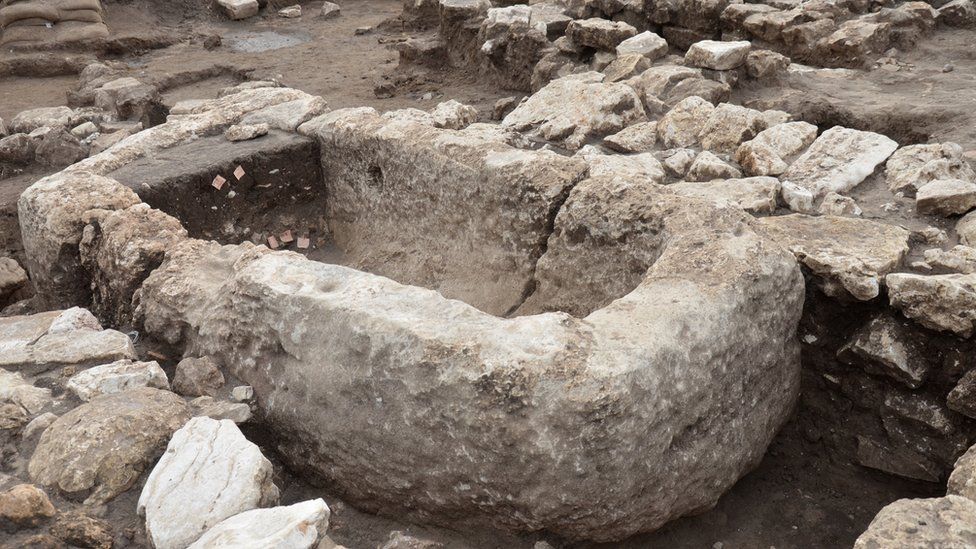
The remains of a 5,000-year-old city have been discovered in Israel – the largest and oldest such find in the region. The city was home to 6,000 people and included planned roads, neighbourhoods, a ritual temple and fortifications.
An even earlier settlement, believed to be 7,000 years old, was discovered beneath the city.
Israeli archaeologists said the discovery was the most significant in the region from that era.
The impressive planning, diverse facilities and public buildings suggest a well-organized society, Israeli authorities said
The stone basin for holding liquids was likely used during religious rituals
“This is the Early Bronze Age New York of our region; a cosmopolitan and planned city where thousands of inhabitants lived,” the excavation directors said in a statement.
“There is no doubt that this site dramatically changes what we know about the character of the period and the beginning of urbanization in Israel,” the statement added.
Rare figurines, often depicting people or animals, were discovered inside the temple
Known as En Esur, the site spans 650 dunams (161 acres), about double the size of previous similar findings. The design of the city included designated residential and public areas, streets and alleys, the Israel Antiquities Authority said.
About four million fragments were found at the site, including rare figurines of humans and animals, pieces of pottery and various tools, some of which came from Egypt.
Authorities said the figurines offer valuable insight into the spiritual life of the community
Some of the figurines have been preserved with great detail
Burnt animal bones found on the site provided evidence of sacrificial offerings. Inhabitants of the city – who were likely drawn to the area by two freshwater springs, fertile land and proximity to trade routes – made their living from agriculture, trading with different regions and cultures.
Archaeologists had been excavating the site for more than two and a half years, with 5,000 teenagers and volunteers participating. The settlement was discovered during excavations preceding the construction of a new road.
About 5,000 teenagers and volunteers have contributed to the excavation, which has been going on for over two and half years
Ancient erotic pottery teaches Peruvians to prevent prostate cancer
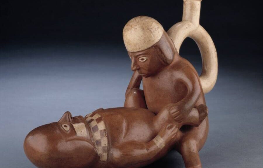
The Larco Museum in Lima, Peru, showcases hundreds of “huacos,” a pre-Columbian term for handicrafts.
The Larco Museum in Peru boasts one of the finest collections of pre-Columbian Mochica sculptures in the world — and most of them are very sexually explicit. But rather than keep them encased in displays, the museum has recently begun to use the ancient artworks to promote self-screening for cancer.
According to Reuters, the exhibition, called “Touch the Genitals of the Mochica,” launched on Feb. 25, 2022, and allowed men to touch the sculptures, which are over 1,000 years old.
With hundreds of items on display, visitors perused a wide variety of sexualized sculptures. Depicting a range of erotic acts and sexual anatomy, these clay ceramics left some museumgoers visibly shy. Ultimately, the museum encouraged touching them to learn how to spot cancers.
“The aim is to bring closer the knowledge of our ancestors about the human body, expressed through these ceramic vessels that we call the ‘Erotic Huacos,’” said Larco Museum Director Ulla Holmquist.
The erotic huacos range from stand-alone figures with giant penises to multi-person sculptures engaged in a variety of sexual positions.
The exhibit came in the wake of devastating figures regarding access to healthcare during the global COVID-19 pandemic. When the annual average of 8,700 male cancer diagnoses in Peru surpassed 10,000 in 2021, health officials perked up.
The museum partnered with the League Against Cancer, a private company that reported that 45 per cent of those diagnosed cases were too advanced to be cured.
“Timely detection of cancer of the external genitalia in men, both the penis and testicles, is very low,” said Giselle Grillo from the League Against Cancer. “Many do not know how to explore their genitals, what palpation is. With this, we give an early diagnosis.”
The men were told to feel for bumps, smooth or rough spots, and other abnormalities in the ancient art in an effort to model how to undertake a proper self-examination.
The League Against Cancer explained that men should wear gloves before lubricating one finger and then inserting it into the rectum to check for soft or hard bumps around the prostate when performing a personal screening. While the organisation is using the artwork of the Moche culture to promote as much, they’ve also posted instructions online.
Most huacos from the Moche culture depict heterosexual anal sex, with vaginal penetration rather infrequent.
The Moche culture thrived in northern Peru from about 150 C.E. through the end of the eighth century and established its capital near present-day Moche in Trujillo. With agriculture as its foundation, the civilization constructed an impressive irrigation network to nurture its crops.
Perhaps most fascinating was their art, which was primarily erotic.
The Moche culture depicted all sorts of activities in their colourful murals and handcrafted ceramics. From fishing and hunting to war and human sacrifice, their iconographies reflected their interests. However, their “huacos,” a pre-Columbian term for handcrafted ceramics, were focused on sex.
As published in the American Anthropologist journal, a 2004 study noted at least 500 huacos were sexually themed. Curiously, most of these depicted heterosexual anal sex and rarely showed vaginal penetration. Scholars believe sex symbolized circulation and flow to the Moche and honored their successful irrigation techniques, the basis of their agricultural society. Historians also posited that the loss of fluids from the human body represented the disappearance of water from the land.
Visitors were encouraged to touch the sculptures and practice checking for lumps.
Mochica art has indeed shown dying warriors bleeding from the nose or people having their eyes torn out by predators — and would catch the attention of cancer-prevention officials 1300 years later.
José Medina, a urologist with League Against Cancer, also wanted to “call on the population to undergo annual medical examinations in order to have a timely diagnosis.”
He said that self-diagnosis is only a first step that will increase early detection, and he was hopeful that the new partnership would raise awareness through its novelty.
Ancient Egyptian Mummy Shows Evidence of Nose Cancer
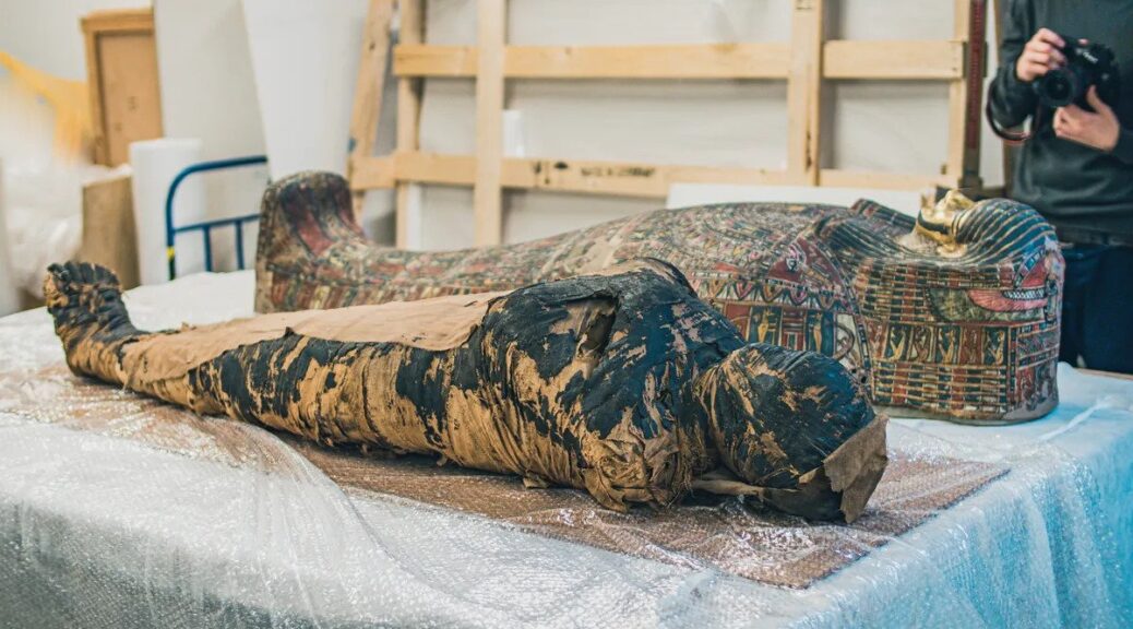
The “Mysterious Lady” Pregnant Mummy and sarcophagus.
Scientists have been busy trying to find the cause of death of the “Mysterious Lady,” a 2,000-year-old ancient Egyptian mummy whose womb contained an extremely well-preserved unborn fetus. By closely studying her skull, they suspect that this ancient soon-to-be mommy likely died of cancer — a discovery that’s blown the minds of oncologists and Egyptologists alike.
Throughout the 19th and 20th centuries, this mummy was assumed to belong to a male priest. However, ground-breaking work by the Warsaw Mummy Project revealed it was, in fact, female. More surprises arose when they discovered she was also the first known example of a pregnant mummy.
Earlier this year, the Warsaw Mummy Project was astounded when CT scans of the “Mysterious Lady” revealed further evidence that the body’s pelvis cavity contained a fetus. Most remarkably, their study showed that the fetus had effectively been “pickled” by the highly acidic and low oxygen environment of the mummified womb, leaving it in remarkably good condition.
The researchers on the project told IFLScience that they often found themselves being asked how this young woman died, so they decided to find out. Further scans of the pregnant mummy’s skull revealed unusual signatures in the bone that suggest she was suffering from cancer.
Skull of the “Mysterious Lady,” a pregnant ancient Egyptian mummy.
In particular, markings on the skull shows signs that modern doctors see in patients with nasopharyngeal cancer, a rare type of cancer that impacts the part of the throat that runs between the back of the nose to the back of the mouth.
“A small pathological change, about 7 millimetres in diameter, a round lesion surrounding an empty space, can be seen on the CT scans, in the bone behind the left orbit. This is most likely a change made by a tumour, possibly a metastatic site,” Wojciech Ejsmond and Marzena Ozarek-Szilke, co-directors of the Warsaw Mummy Project, told IFLScience.
“This type of metastatic change on the bones of the skull occurs, among others, after adenoma, but if it was this type of tumour, histopathological tests will give us a definitive answer. In addition, there are large cavities in the bones of the face, including the nasal cavity, maxillary sinuses, and the palatal part of the maxillary bones,” Ejsmond and Ozarek-Szilke explained.
“The changes in the craniofacial bones are corresponding with nasopharyngeal cancer in modern patients.”
The yellow arrow is indicating a change made by a tumour, possibly a metastatic site, on the Mysterious Lady’s Skull.
To verify the cancer diagnosis, the researchers need to properly examine the mummy’s tissues. Identifying cancer within the actual tissues could also raise some other possibilities that scientists have excited about.
The team from the Warsaw Mummy Project says that oncologists could determine the “molecular signature” of cancer found in the mummy and then compare it with current cancers. This, they say, could provide some valuable insights into the evolution of cancer.
A bunch of ancient mummies have been discovered with possible signs of cancer in their bodies before. In 2017, scientists discovered the world’s oldest known cases of breast cancer and multiple myeloma in two ancient Egyptian mummies.
The two bodies, dating 2000 BCE and 1,800 BCE, were found buried at the pharaonic necropolis of Qubbet el-Hawa in Aswan and likely belonged to the elite classes of the governing Egyptian families of Elephantine.
Despite their riches and fame, nothing could save them from an untimely death.
Scientists have discovered the world’s oldest and best-preserved sperm from tiny shrimps, measuring a massive 1.3 millimetres and dating back to 17 million years in Australia.
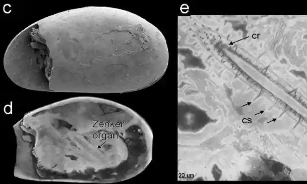
Clockwise from the top left, a microscopic image of the Riversleigh fossil ostracod, details of the fossil Zenker organ and a virtual reconstruction of the fossil.
Preserved giant sperm from shrimps were found at the Riversleigh World Heritage Fossil Site in Queensland and are the oldest fossilised sperm ever found in the geological record, researchers said.
The shrimps lived in a pool in an ancient cave inhabited by thousands of bats, and the presence of bat droppings in the water could help explain the almost perfect preservation of the fossil crustaceans.
The giant sperm are thought to have been longer than the male’s entire body but are tightly coiled up inside the sexual organs of the fossilised freshwater crustaceans, which are known as ostracods.
“These are the oldest fossilised sperm ever found in the geological record,” said Professor Mike Archer, from the University of New South Wales (UNSW), who has been excavating at Riversleigh for more than 35 years.
“The discovery of fossil sperm, complete with sperm nuclei, was totally unexpected,” said Archer.
A UNSW research team led by Archer, Associate Professor Suzanne Hand and Henk Godthelp collected the fossil ostracods from the Bitesantennary Site at Riversleigh in 1988.
They were sent to John Neil, a specialist ostracod researcher at La Trobe University, who realised they contained fossilised soft tissues.
He drew this to the attention of European specialists, including the lead author of the research paper, Dr Renate Matzke-Karasz, from the Ludwig Maximilian University of Munich, who examined the specimens with Dr Paul Tafforeau at the European Synchrotron Radiation Facility in Grenoble, France.
The microscopic study revealed the fossils contain the preserved internal organs of the ostracods, including their sexual organs.
Within these are the almost perfectly preserved giant sperm cells, and within them, are the nuclei that once contained the animals’ chromosomes and DNA.
Also preserved are the Zenker organs – chitinous-muscular pumps used to transfer the giant sperm to the female. The researchers estimate the fossil sperm is about 1.3 millimetres long, about the same length or slightly longer than the ostracod itself.
“About 17 million years ago, Bitesantennary Site was a cave in the middle of a vast biologically diverse rainforest. Tiny ostracods thrived in a pool of water in the cave that was continually enriched by the droppings of thousands of bats,” said Archer.
The bats could have played a role in the extraordinary preservation of the ostracod sperm cells, UNSW’s Associate Professor Suzanne Hand said.
The steady rain of poo from thousands of bats in the cave would have led to high levels of phosphorus in the water, which could have aided the mineralisation of the soft tissues.
The study was published in the journal Proceedings of the Royal Society B
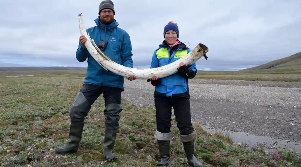
Million-year-old mammoth genomes set a record for ancient DNA
Image from the Centre for Palaeogenetics, Stockholm, of steppe mammoths, thought to have preceded the woolly mammoth.
Teeth from mammoths buried in the Siberian permafrost for more than a million years have led to the world’s oldest known DNA being sequenced, according to a study that shines a genetic searchlight on the deep past.
Researchers said the three teeth specimens, one roughly 800,000 years old and two more than a million years old, provided important insights into the giant ice age mammals, including into the ancient heritage of, specifically, the woolly mammoth.
The genomes surpass the oldest previously sequenced DNA, that of a horse dating from 560,000 to 780,000 years ago.
Love Dalén, professor of evolutionary genetics at the Centre for Palaeogenetics in Stockholm, was the senior author of the study, published in Nature. He said: “This DNA is incredibly old. The samples are a thousand times older than Viking remains, and even pre-date the existence of humans and Neanderthals.”
The mammoths were originally discovered in the 1970s in Siberia and had been kept at the Russian Academy of Sciences in Moscow.
Palaeontologists Love Dalén and Patricia Pecnerova with a mammoth tusk on Wrangel Island, Arctic Ocean.
Researchers first dated the specimens geologically, using comparisons with other species, such as small rodents, known to be unique to particular time periods and found in the same sedimentary layers.
This suggested that two of the mammals were ancient steppe mammoths more than a million years old. The youngest of the trio is one of the earliest woolly mammoths yet found.
The team also extracted genetic data from tiny samples of powder from each mammoth tooth, “essentially like a pinch of salt you would put on your dinner plate”, Dalén told a press briefing.
While the material had degraded into very small fragments, the scientists were able to sequence tens of millions of chemical base pairs – which make up the strands of DNA – and conduct age estimates from the genetic information.
This suggested that the oldest mammoth, named Krestovka, was even older than thought, at approximately 1.65m years, while the second, Adycha, was about 1.34m years old, and the youngest, Chukochya, was 870,000 years old.
Dalén said that, regarding the oldest mammoth, the DNA dating process could indicate the creature was probably about 1.2m years old, as suggested by the geological evidence. But it was possible the specimen was older than that and had thawed out of the permafrost at one point and then become wedged in a more recent layer of sediment.
Tom van der Valk, of the Science for Life Laboratory, Uppsala University, in Sweden, said the DNA fragments were like a puzzle with millions of tiny pieces “way, way, way, smaller than you would get from modern high-quality DNA”.
Using a genome from an African elephant, a modern relative of the mammoth, as a blueprint for their algorithm, the researchers were able to reconstruct parts of the mammoth genomes.
The study found that the mammoth named Krestovka represented a previously unrecognised genetic lineage, which researchers estimated diverged from other mammoths around two million years ago and was ancestral to those that colonised North America.
The study also traced the lineage from the million-year-old Adycha steppe mammoth to Chukochya and other more recent woolly mammoths.
Researchers also found gene variants associated with life in the Arctic, such as hairiness, thermoregulation, fat deposits and cold tolerance in the older specimen, suggesting mammoths were already hairy long before the woolly mammoth emerged.
Siberia has alternated between dry and cold ice age conditions and warm, wet periods. Now climate change is causing the permafrost to melt and reveal more specimens, Dalén said. There was a risk that amid more rainfall, remains could be washed away, however.
Dalén said new technologies could allow the sequencing of even older DNA from remains found in the permafrost, which dates back 2.6m years.
Researchers are keen to look at creatures such as the ancestors of moose, musk ox, wolves and lemmings, to shine a light on the evolution of modern species.
“Genomics has been pushed into deep time by the giants of the ice age – the wee mammals that surrounded them might soon also have their day,” said Alfred Roca, a professor at the department of animal sciences at the University of Illinois, US, in a comment piece published in Nature.
Neanderthals helped create early human art, researcher says
When Neanderthals, Denisovans and homo sapiens met one another 50,000 years ago, these archaic and modern humans not only interbred during the thousands of years in which they overlapped, but they exchanged ideas that led to a surge in creativity, according to a leading academic.
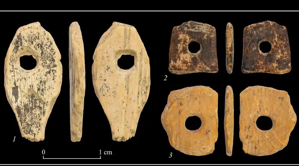
Denisovan ornaments are made from mammoth tusks from Denisova Cave in Siberia.
Tom Higham, a professor of archaeological science at the University of Oxford, argues that their exchange explains “a proliferation of objects in the archaeological record”, such as perforated teeth and shell pendants, the use of pigments and colourants, decorated and incised bones, carved figurative art and cave painting: “Through the early 50,000s, up to around 38,000 to 40,000 years ago, we see a massive growth in these types of ornaments that we simply didn’t see before.”
Between 40,000 and 150,000 years ago, our cousins included the Neanderthals, Homo floresiensis, Homo luzonesis and the Denisovans.
“Now it’s just us; there aren’t any other types of humans on the planet,” Higham says. “We always thought that the origins of art and complex cognitive thought were the hallmark of us – modern humans. This was called the human revolution. The basis of this hypothesis, which came out in the 1970s, was that humans came out of Africa and brought with them a cognitive ability that no other types of humans – particularly Neanderthals – had … Now what we think is happening is that … it’s not restricted to modern humans at all.
“If our groups were interbreeding, then cultural transfer – the exchange of ideas, thoughts and language – may well also have been happening. Humans are good at picking up new ideas.”
The latest research, which draws on recent findings by international scientists and archaeologists, will feature in Higham’s forthcoming book, The World Before Us: How Science is Revealing a New Story of Our Human Origins, to be published by Viking on 25 March.
He writes that Earth was a primevally complicated place 50,000 years ago: “To borrow from the words of Tolkien, we should think of it as a veritable ‘Middle Earth’ in terms of the diversity of forms of the human family that existed at the time. There were five, six, or even more, different types of human presence in various parts of the world.”
In the book, through the latest scientific and technological advances – including radiocarbon dating and ancient DNA analysis – Higham explores how we became the only humans on Earth and how our forebears lived – “and live on in our genes today”.
He is a world expert in technology that is revolutionising what we know about the previous human species. Archaeological and genetic discoveries are transforming our understanding of our ancestors.
Higham is among academics who have been working in Siberia, where a new type of human, the Denisovans, was discovered in a remote cave in 2010.
From a finger bone fragment so tiny that it would previously have been unidentifiable, they were able to extract crucial DNA details that link them to people spread across a vast area of Eurasia, including south-east Asia.
He says: “Denisovans are closely related to Neanderthals and to us. As with Neanderthals, we interbred with them. People today, depending on where they are geographical, have a small amount – and, in some cases, big amounts – of Denisovan DNA.
“At the site of the Denisova cave, we’ve also uncovered evidence that intriguingly suggests that Denisovans too might have been involved in making personal ornaments and doing the kinds of things that hitherto we only thought were the exclusive preserve of us and later Neanderthals.”
That evidence includes rings and beads made out of mammoth tusks and ostrich eggshells. “Were these and the other ornaments made by both Denisovans and modern humans?” Higham asks.
New research means that all sorts of artworks and decorative items that have been assumed to be linked to the earliest modern human could have been created by Neanderthals or Denisovans, in the absence of other evidence.
Higham says: “The weight of evidence now suggests that if there was the cultural transmission, it probably occurred in both directions and that the earliest evidence for the beginnings of complex behaviour in Europe was prior to the widespread arrival of Homo sapiens.”
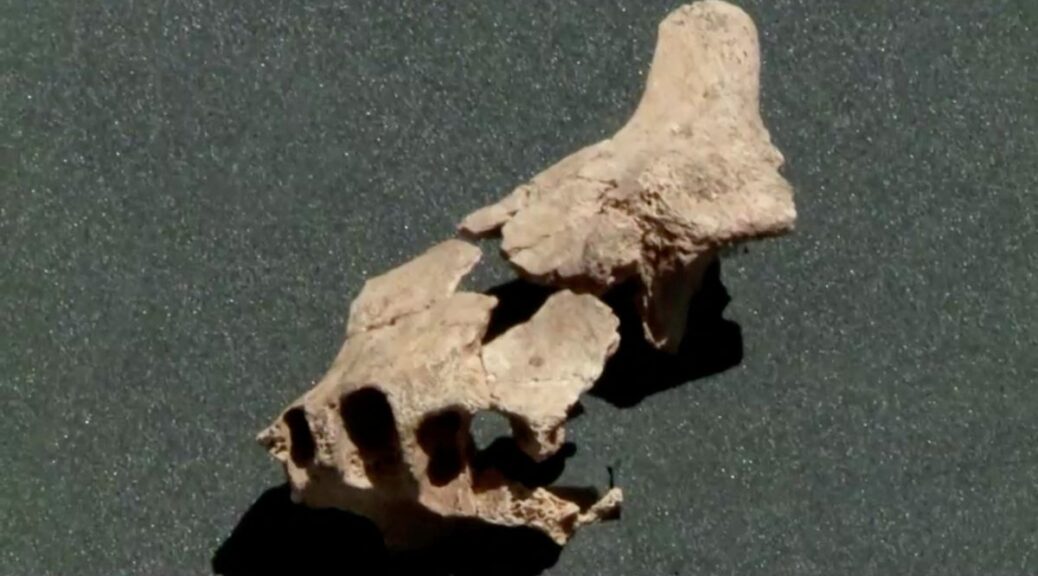
A jawbone fragment discovered in northern Spain last month could be the oldest known fossil of a human ancestor found to date in Europe, Spanish palaeontologists said on Friday. The researchers said the fossil found at an archaeological site on 30 June in the Atapuerca mountain range was about 1.4m years old.
Elena Moreno, a member of the Atapuerca research team, works on the jawbone of a hominid in the National Centre for Research on Human Evolution in Burgos.
Until now, the oldest hominid fossil found in Europe was a jawbone found at the same site in 2007 that was determined to be 1.2m years old.
Atapuerca holds one of the richest records of prehistoric human occupation in Europe.
Researchers will now have to complete their first estimate for the age of the jawbone fragment using dating techniques, palaeoanthropologist José María Berúmudez de Castro, the co-director of the Atapuerca research project, said during a news conference.
Since the jawbone fragment was found some 2 metres below the layer of earth of the 2007 find “it is logical and reasonable to think it is older”, he said.
The dating of the jawbone fragment will be carried out at the National Centre for Research on Human Evolution in Burgos, a city located about six miles from Atapuerca.
The process should take six to eight months to complete, Bermúdez de Castro said.
The analysis could help identify which hominid species the jawbone fragment belongs to and better understand how human beings evolved on the European continent.
Scientists have so far been unable to determine with certainty the species of the jawbone discovered in 2007. The fossil could correspond to Homo antecessor, discovered in the 1990s.
The Atapuerca Foundation, which runs the archaeological site, said it was very likely the jawbone fragment “belongs to one of the first populations that colonised Europe”.
In 2000 the archaeological site of Atapuerca was included on Unesco’s list of world heritage sites, giving it access to UN conservation funding.
It contains thousands of hominid fossils and tools including a flint discovered in 2013 that is 1.4m years old.
8,000-year-old Yarmukian ‘Mother Goddess’ figurine uncovered at Sha’ar HaGolan
Before the Israelis and the Palestinians, before the Greek and the Roman empires, before the Kingdom of Israel and the Kingdom of Judah, before the Umayyad Caliphate and the Crusader Kingdom of Jerusalem – there were the Yarmukians.
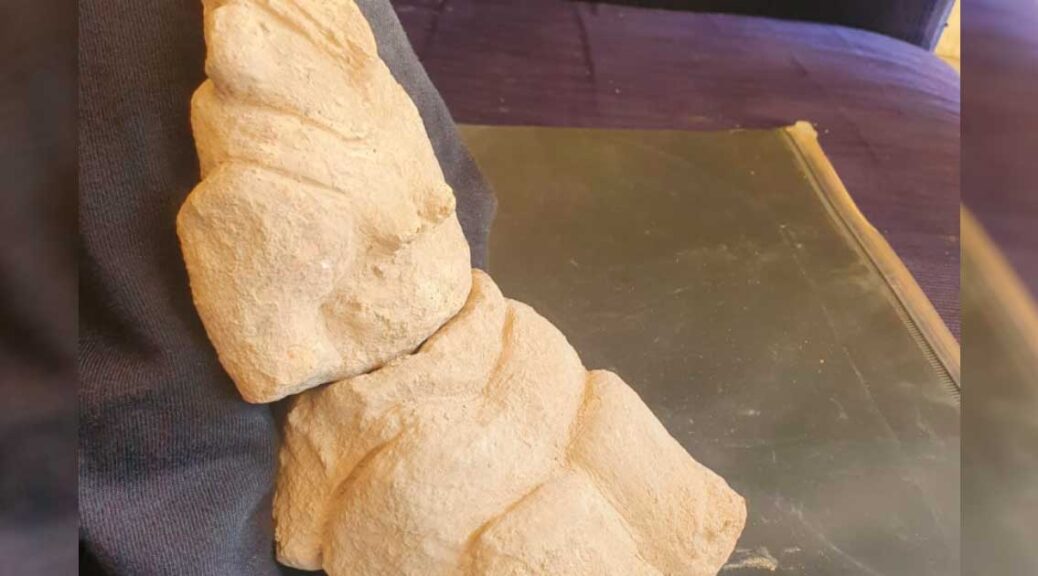
An impressive 8,000-year-old Yarmukian ceramic “Mother Goddess” figurine was uncovered at renewed excavations at the Sha’ar HaGolan Yarmukian archaeological site.
This 8,000-year-old Neolithic agricultural culture is considered the first culture in the prehistoric area of what today is called Israel. It is one of the oldest cultures in the Levant to make use of ceramic pottery, with a distinctive style of herringbone decorations incised in horizontal and diagonal lines over the body of their ceramic cooking, serving and storage vessels.
The culture is also known for its enigmatic and iconic “Mother Goddess” figurines, which are believed to have been part of a Yarmukian fertility cult. Renewed excavations at the Sha’ar Hagolan Yarmukian archaeological site at the Sha’ar Hagolan kibbutz this month have revealed an unusually large and impressive ceramic goddess figurine of the “Mother Goddess.”
Created in the typical seating pose, the 20-centimetre figurine was found broken in two pieces next to the wall of a home, said excavation co-director Anna Eirikh-Rose, Israeli Antiquity Authority Judea district archaeologist, who is doing her doctoral research at the Hebrew University on Neolithic pottery.
Sha’ar HaGolan excavation co-director Dr. Julien Vieugue of the French Center for Research in Jerusalem holds the 8,000-year-old ceramic ”Mother Goddess” figurine uncovered at renewed excavations at the Sha’ar HaGolan archaeological site
The broken figurine was covered by a bracelet with a red bottom, the colour which represented fertility. A schematic stone with etched eyes and mouth was also uncovered. The excavation is being carried out in conjunction with the French Center for Research in Jerusalem under the co-direction of Dr. Julien Vieugue.
“This woman ceramic figurine is a hallmark of Yarmukian culture,” Eirikh-Rose said. “This is one of the largest examples of the figurine found. It is of a large, seated woman with big hips, a unique pointed hat and what is known as ‘coffee-bean’ eyes and a big nose. One hand is positioned on her hip and the other one under her breast.”
Symbolism
Though dubbed “coffee-bean” eyes, the traditional eyes of the figurine more likely represented kernels possibly of wheat, or more likely barley, she said.
All the small details of the figurine are important for its cultic symbolism, she said, and the process of creating such a figurine involved a complex method of wrapping and layering the clay around a central cylindrical core.
“It is really impressive, and was a very elaborate way of making a figurine,” she said. “It was not simple to make.”
The Yarmukian culture was poised at the dramatic human juncture of the transition from a foraging culture to a permanent settlement, which also changed the development of architecture. It was so named for the discovery of the archaeological remains at the Sha’ar Hagolan site dated to 6,400-6,000 BCE near the northern bank of the Yarmuk River in the central Jordan Valley.
The history of the Sha’ar HaGolan site
First excavated in 1949, the Sha’ar Hagolan site was identified by Hebrew University Professor Moshe Stekelis as belonging to the Yarmuk culture. A subsequent excavation by Hebrew University Prof. Yosef Garfinkel ended in 2004.
The finds are on exhibit at the Museum of Yarmukian Culture at the kibbutz.
Eirikh-Rose said the current re-excavation of the site was begun next to previous excavations. It is meant to expose the site layer by layer, until reaching the Neolithic pre-ceramic level of the settlement to research the culture’s use and production of ceramic pottery.
“Although the site of Sha’ar Hagolan has been dug several times, revealing the additional layers one at a time, this time there is a clear purpose for our excavation: we want to understand the origin and mechanism of development of the pottery production in the world of this ancient period in the Levant region,” she said.
Eirikh-Rose noted that 8,000 years ago, the inhabitants of this site began to use pottery vessels and mass-produce them.
“This is the first culture of the Neolithic revolution to use and manufacture pottery vessels on a large scale, not just one bowl here and one bowl there,” she said.
Previous excavations at the Sha’ar Hagolan site have uncovered planned streets, courtyard houses and smaller mother goddess figurines, as well as incised pebble face figurines and eye figurines.
At its height, the settlement covered an area spanning 20 hectares, making it one of the largest settlements in the world at that time, said Eirikh-Rose. Although other Yarmukian sites have been identified since, Sha’ar Hagolan is the largest, probably indicating its role as a Yarmukian cultural center.
Eirikh-Rose said the newly uncovered figurine will be taken for residue analysis, which will help researchers establish what types of clay were used to create it. Continued study of these figurines may also help researchers in their quest to determine whether the “Mother Goddess” was used in cultic practices or was already part of established religion.
“There are so many theories,” she said. “This is a big question to study– the development of religious beliefs and culture.”