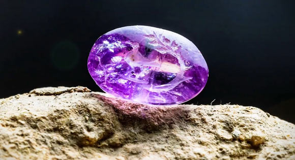
An amethyst gemstone seal from the Second Temple period has a unique engraving: a bird and a branch with five fruits, according to the Israel Antiquities Authority (IAA).
The 2,000-year-old seal was discovered in the bedrock foundations of the Western Wall in Jerusalem, Israel.
The tiny artefact has a hole for the attachment of a metal wire enabling it to be worn as a ring.
The 2,000-year-old amethyst seal was found in Jerusalem, Israel.
It was examined by IAA archaeologist Dr Eli Shukron, Professor Shua Amorai-Stark from Kaye Academic College of Education, Dr Malka Hershkovitz from Jewish Institute of Religion, and their colleagues.
“Seals were used to sign documents and could also be fashionable items serving as jewellery,” the researchers said.
The amethyst seal is approximately 1 cm (0.4 inches) long and 0.5 cm (0.2 inches) wide.
It is engraved with a dove next to a thick, long, and fruit-bearing branch.
“The plant engraved on the stone may be the well-known persimmon plant mentioned in the Bible, Talmud, and historical sources,” the scientists said.
“The Biblical persimmon, which is not related to today’s orange persimmon fruit, is known from Biblical and historical sources.”
During the Second Temple period, the plant was used as one of the more expensive ingredients for producing the Temple incense, perfume, medicines, and ointments.
“This is an important find because it may be the first time a seal has been discovered with an engraving of the precious and famous plant, which until now we could only read about in historical descriptions,” Dr Shukron said.
“This impressive seal provides a glimpse into the daily lives of the people who lived in the days of the Second Temple.”
2,000-Year-Old Battle Site Uncovered in Switzerland
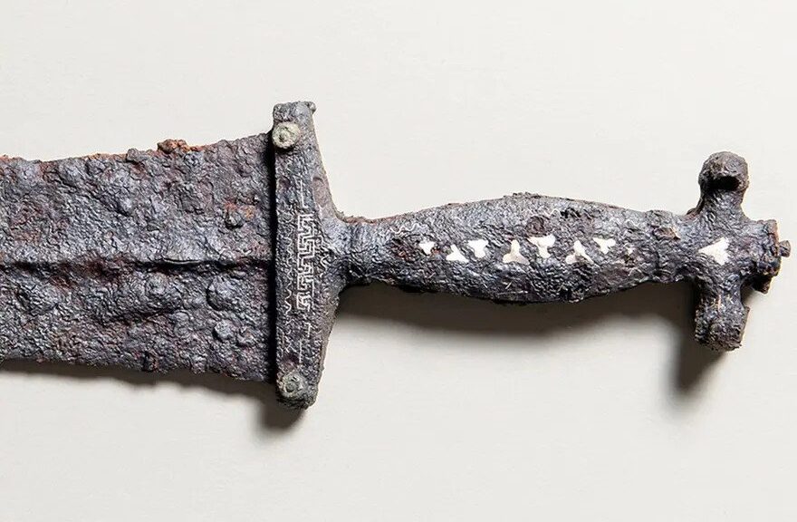
The finds – including a dagger, well-preserved slingshot stones, coins, nails and part of a shield – are assumed to have been left on the battlefield after a clash between Romans and a local tribe at around 15BC.
A dagger is one of the hundreds of objects uncovered on the ancient battlefield.
Lucas Schmid, who volunteers for the local archaeological association, uncovered the remains using a metal detector at a remote southeast corner of Switzerland, near the Crap-Ses gorge between the towns of Tiefencastel and Cunter.
Other artefacts had previously been unearthed at the location, but the site was considered to have been picked clean by previous sweeps.
Schmid proved this was not the case after discovering a 2,000-year-old Roman dagger.
This alerted an archaeology team from the University of Basel who has found several hundred other objects during an ongoing search of the 35,000 square metre site in September. These artefacts have now been made public.
How the battle unfolded
It is assumed that a battle took place between Roman forces and a local Raetian tribe near Cunter in what is now canton Graubünden.
“It looks like the locals were holed up and were shot at by the Romans with slingshot and catapults,” Peter Schwarz, professor of Provincial Roman Archaeology at the University of Basel, told Swiss public broadcaster, SRFExternal link.
Schwarz believes that as many as 1,500 soldiers took part in the battle, making it a fairly minor skirmish compared to other Roman battlegrounds in Europe.
The coins and type of shoe nails found offer firm evidence of the time period of the battle. But the team is hoping to narrow down the date even further and hypothesize that it could be linked to a known decree from Roman Emperor Augustus to bring the area under Roman control in 15BC.
“This is the first time that remnants from a Roman battle site have been found in Switzerland,” Schwarz told SWI swissinfo.ch. “It seems that the Romans attacked their enemy on one side of the valley and them drove them over a river to the other side, before attacking again.”
Dig to continue next year
Excavations will continue in the region next year, organised by the University of Basel along with the cantonal and federal authorities. So far no grave sites have been discovered and it is not known how many people died in the battle.
Raetian tribes occupied the eastern Alps at the time of the battle, including parts of modern-day Austria and Italy. The Romans conquered the region and named the area Raetia under Augustus.
The Swiss portion of Raetia eventually became the modern-day canton Graubünden.
Archaeological evidence of the Roman occupation of Switzerland is regularly unearthed. One of the most spectacular finds was a collection of mosaics in the western town of Orbe.
A mummy discovered in a vast burial ground of Egypt’s pharaohs could change how ancient history is understood
A new analysis of an ancient Egyptian mummy suggests that advanced mummification techniques were used 1,000 years earlier than previously believed, rewriting the understood history of ancient Egyptian funerary practices.
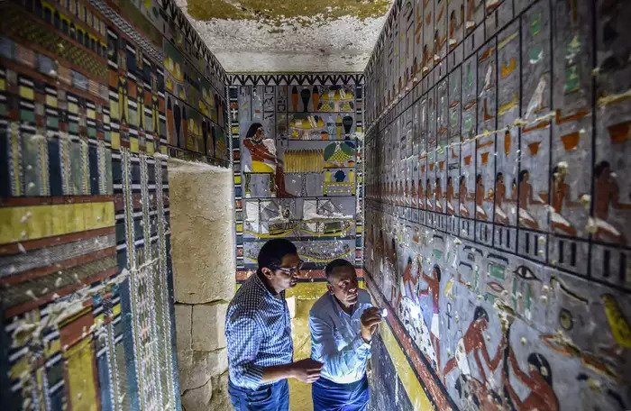
Mohamed Mujahid (L), head of the Egyptian mission which discovered the tomb of the ancient Egyptian nobleman Khuwy inspects the tomb’s walls inside at the Saqqara necropolis on April 13, 2019.
The discovery centres around a mummy, known as Khuwy, believed to have been a high-ranking nobleman. He was excavated at the necropolis, a vast ancient burial ground of Egyptian pharaohs and royals near Cairo, in 2019.
Scientists now believe that Khuwy is much older than previously thought, dating back to Egypt’s Old Kingdom, which would make him one of the oldest Egyptian mummies ever to be discovered, The Observer reported.
The Old Kingdom spanned 2,700 to 2,200 B.C.E and was known as the “Age of the Pyramid Builders.”
Khuwy was embalmed using advanced techniques thought to have been developed much later. His skin was preserved using expensive resins made from tree sap, and his body was impregnated with resins and bound with high-quality linen dressings.
The new analysis suggests that ancient Egyptians living around 4,000 years ago were carrying out sophisticated burials.
“This would completely turn our understanding of the evolution of mummification on its head,” Professor Salima Ikram, head of Egyptology at the American University in Cairo, told The Observer.
“If this is indeed an Old Kingdom mummy, all books about mummification and the history of the Old Kingdom will need to be revised.”
Workers excavate a burial site at Saqqara, January 17, 2021.
“Until now, we had thought that Old Kingdom mummification was relatively simple, with basic desiccation – not always successful – no removal of the brain, and only occasional removal of the internal organs,” Ikram told The Observer. Ikram was surprised by the amount of resin used to preserve the mummy, which is not often recorded in mummies from the Old Kingdom.
She added that typically more attention was paid to the exterior appearance of the deceased than the interior.
“This mummy is awash with resins and textiles and gives a completely different impression of mummification. In fact, it is more like mummies found 1,000 years later,” she said.
Ikram told The National that the resin used would have been imported from the Near East, most likely Lebanon, demonstrating that trade with neighbouring empires around that time was more extensive than previously thought.
The discovery has been documented in National Geographic’s new series, Lost Treasures of Egypt, which starts airing on 7 November. Tom Cook, who produced the series for Windfall Films, told The Observer that Ikram initially could not believe that Khuwy dated back to the Old Kingdom because of the advanced mummification techniques.
“They knew the pottery in the tomb was the Old Kingdom but [Ikram] didn’t think that the mummy was from [that period] because it was preserved too well,” Cook told the outlet.
“But over the course of the investigation, she started to come round [to the idea].”
Khuwy’s ornate tomb featured hieroglyphics that suggested the burial took place during the Fifth Dynasty period, spanning the early 25th to mid-24th century B.C.E, The Smithsonian said.
Archaeologists also found pottery and jars used to store body parts during the mummification process that dated back to that time.
Ikram’s team will conduct more tests to confirm that the remains do belong to Khuwy.
She told The National that one possibility was that another person could have been mummified and buried centuries later in a re-purposing of the tomb.
“I remain hesitant until we can conduct carbon-14 dating,” Ikram told the outlet, adding that it would likely take six to eight months.
New Horrifying Secrets of Peru’s Ancient Civilizations Unearthed in The Andes
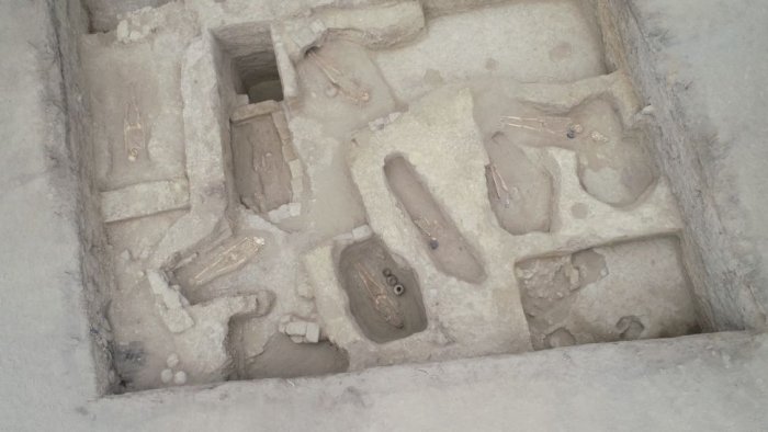
The foothills of the Andes mountains are revealing their bloody secrets: the ancient skeletons of sacrificed children. Archaeologists have unearthed 29 human bodies entombed approximately 1,000 years ago at Huaca Santa Rosa de Pucalá, an archaeological site in the Lambayeque region of northwestern Peru.
An overhead view of the excavation site.
Four of the skeletons – belonging to two children, a teenager and one adult – date to the Wari culture.
These four skeletons represent the region’s first known examples of human offerings from the Wari civilization, Edgar Bracamonte Lévano, the excavation’s director and research archaeologist with the Royal Tombs of Sipán museum, told Live Science in an email.
In addition to human remains, the excavation uncovered skeletons from eight guinea pigs, as well as several alpacas and llamas, all of which were likely sacrificed. They also uncovered pots, bottles, and a knife with a half-moon-shaped blade.
Bracamonte Lévano recognized the tombs as Wari because they were surrounded by three distinctive, D-shaped enclosures typical of the culture’s religious spaces.
The human offerings may have been “part of a possible ritual carried out at the time of starting the construction of these Wari-style religious spaces,” he said.
In addition to the four human offerings, the archaeological team uncovered a fifth individual who had undergone secondary burial. “That is to say, he was buried elsewhere and [then] reburied inside the D-shaped enclosure,” Bracamonte Lévano said.
A human skeleton unearthed at Huaca Santa Rosa de Pucalá
The Wari civilization flourished along the mountains and coasts of modern-day Peru from around AD 500 to 1000.
Wari people were known for their finely woven textiles and sculpted pottery, as well as their roads and terraced agriculture, according to the World History Encyclopedia. These roads would later be incorporated into parts of the Inca Empire.
While the exact structure of Wari society remains open to debate, archaeologists have found evidence suggesting that religion was deeply intertwined with politics and that women were included at the highest levels of governance, as Live Science previously reported.
The other 25 skeletons found buried – though not sacrificed – at the site belonged to the Mochica, or Moche, culture. This civilization thrived in what is now Lambayeque from around AD 100 to 700, and would later be supplanted by the Wari.
Unlike Wari art, which tends toward abstract shapes and patterns, Moche art is famous for its more literal, naturalistic style. That makes artefacts from the two cultures easily distinguishable, Bracamonte Lévano said.
Among the most significant Moche discoveries in recent years is the Lady of Cao mummy, a tattooed noblewoman whose forensic reconstruction was the subject of a 2017 National Geographic documentary.
The Lord of Sipán, another famous Moche mummy discovered in 1987, resides in the Royal Tombs of Sipán Museum under Bracamonte Lévano’s watchful eye.
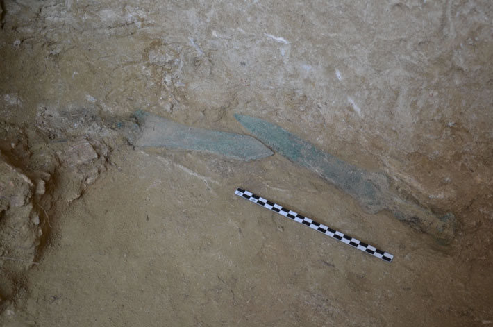
Bronze Age swords and sets of bounties Unearthed in Greece
The first period of this year’s excavation in the Trapeza plateau, eight kilometres southwest of Aegio, was completed, bringing to light, among other things, valuable sets of gifts and bronze swords. The place is identified with Rypes, a city that flourished in early historical times and participated in colonization, founding Croton in great Greece.
Excavation in the prehistoric settlement
The excavation focused on the research of the Mycenaean necropolis, which develops on the southwestern slope of the plateau and is located on the ancient road that led to the citadel of historical times.
The tombs are chambered, carved into the soft sandy subsoil. Their use was long-lasting and intensive, already during the first palace period of the Mycenaean world, in parallel with the prosperity of the great centres of Mycenae, Tiryns and Pylos.
Significant reuse of the tombs dates back to the 12th century BC, when the tombs were reopened and repeatedly while being a place of burial customs and complex ritual practices until the end of the Bronze Age, during the 11th century BC.
The excavation at the necropolis yielded valuable sets of gifts consisting of vases, a number of seal stones and all kinds of beads and voices from various materials – glass, faience, gold, corneol, mountain crystal – composing necklaces and ornate jewellery in the shape of jewels, in trade relations with the eastern Aegean and Cyprus.
The chamber of tomb 8, in the shape of a rectangle, which was investigated this year, presented a complex stratigraphy. In the first layer of tombs of the 12th c. BC, three burials were investigated by country, decorated with pseudo-mouthed amphorae.
The bones of the older tombs had been removed and placed with respect and great care in two superimposed piles at the back of the chamber in contact with the walls of the tomb. At the top of these excavations, three written clay alabasters and an amphora date these first burials to the early palace period (14th century BC).
Among the bones and offerings that accompanied these ancient burials, glass beads and cornaline, a clay horse figurine, was placed an exceptionally preserved bronze sword.
The big sword between the bones of the recovery
At the base of the pile of bones, two more intact bronze swords were also found, which also save part of their wooden handles. The three swords belong to different types, Sandars D and E, and date back to the heyday of the Mycenaean palace period.
The presence of these weapons, as well as the long spears of the same chronological period found during the excavation in neighbouring tombs in the necropolis of the Bank, is particularly important. It is distinguished from the other necropolises of Achaia by emphasizing the direct dependence of the local community on the powerful palace centres.
The weapons are products of the palace workshops, perhaps of Mycenae, thus in line with the Epic and the mythological tradition handed down to us.
According to it, Achaia belonged to the kingdom of Agamemnon and the conqueror of Mycenae gathered in neighbouring Aigio the most valuable men in order to discuss how the campaign against the Priam state should be carried out.
The location of the Mycenaean settlement of Trapeza is still not clear enough.
Probably, during the early cycle of use of the necropolis, the settlement was located on a hill, about 100 meters south of the Bank.
This year, in parallel with the research in the Mycenaean necropolis, the excavation of part of the settlement, revealed part of a building, perhaps a mansion. It is a wide rectangular room with a hearth in the centre and typical pottery that dates back to the 17th century. e.g.
The systematic excavation at Trapeza Aigio, ancient Pollutants, is led by Dr. Andreas G. Vordos, archaeologist of the Ephorate of Antiquities of Achaia.
Elisabetta Borgna, Professor of Aegean Archeology at the University of Udine, participates in the interdisciplinary research program of the Mycenaean necropolis and the prehistoric settlement with a group of students from the Universities of Udine, Trieste and Venice, as well as postgraduate students.
The main sponsor of the excavation at the Bank of Egialia, ancient Pollutants, is the AG Foundation. Leventis. The excavation work is also supported by Olympia Odos SA.
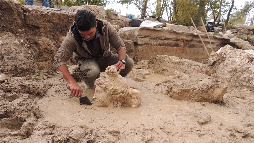
An archaeologist unearths the statue head of the goddess of love and beauty Aphrodite, Aizanoi, Kütahya, western Turkey, Oct. 29, 2021.
The excavations in the ancient city, which was included in the UNESCO World Heritage Tentative List in 2012 and located 50 kilometres (31 miles) from the city centre, are being continued by the Kütahya Museum Directorate.
Excavation coordinator Professor Gökhan Coşkun of Dumlupınar University told Anadolu Agency (AA) that the work in Aizanoi, a site which dates back 5,000 years, was carried on without interruption with 100 workers and 27 technical personnel.
Noting that they have been sustaining their work in a creek bed in the ancient city of Aizanoi recently, Coşkun told that the statuary heads of Aphrodite and Dionysus were unearthed in this creek bed.
“These are important findings for us, as they show that the polytheistic belief culture of ancient Greece existed for a long time without losing its importance in the Roman era,” he said.
“The findings suggest that there may have been a sculpture workshop in the region.”
Home to one of the most well-preserved temples in Turkey, dedicated to the Greek god Zeus, the city of Aizanoi is easily comparable to Ephesus in its grandeur and importance.
Initially inhabited by the Phrygians, the area was converted into a city in the first century B.C. by the Romans and includes unique spots such as a temple; four roman bridges, two of which are still in use today; the world’s first known indoor marketplace, with inscriptions of the prices of goods sold still visible on the walls; theatres; roman baths and an ancient sacred cave.
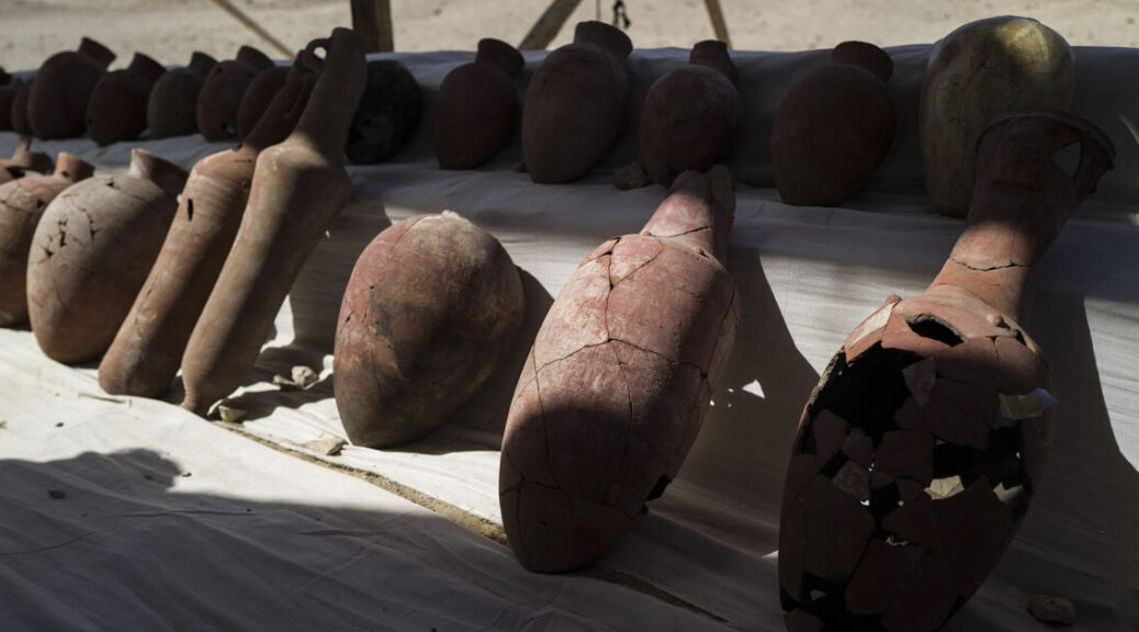
New Discoveries Found Under Demolished Historic Palace In Egypt – Al-Monitor
An Egyptian archaeological mission working on the site of the Tawfiq Pasha Andraos Palace – which was recently demolished – unveiled a number of amphoras and lamps dating from the Byzantine era.
Mustafa Waziri, secretary-general of the Supreme Council of Antiquities, said on October 17 that the find is part of a series in the city of Luxor, in southern Egypt. He said excavations were underway at the site.
In August, Egyptian authorities demolished the 120-year-old Tawfiq Pasha Andraos Palace near the Luxor Temple and overlooking the Nile, based on a decision by the Ministry of Antiquities that archaeological sites lay beneath it.
The palace hosted Saad Zaghloul, leader of the 1919 revolution after British authorities banned his travel. It contained many rare items and a gold-plated car, among other valuables. In 2013, the bodies of Andraos’ two daughters, killed in mysterious circumstances, were found inside the palace.
The palace of Andraos, which was a member of the Luxor House of Representatives from 1921 to 1935, is not the first to be demolished by the Egyptian authorities. In 2009, the Mubarak government destroyed the nearby palace of Yassa Andraos, Tawfik’s brother, as part of a plan to turn Luxor into an open museum.
But the move was controversial. “Even the Louvre museum has monuments underneath and has never been demolished,” Bassam al-Shammaa, Egyptologist and tour guide, told Al-Monitor.
“Nothing justifies destroying antiquity for the good of another, especially since Egypt has witnessed successive historical civilizations. It is simply unthinkable to demolish antiquity because there is another in below.
Shammaa added that Luxor Palace has located a short walk from famous Roman monuments opposite the first western edifice of Luxor Temple.
The most famous monument belongs to Emperor Hadrian and is dedicated to the god Serapis, whose statue can be found in the northwest corner of the Luxor Temple courtyard, very close to the Andraos Palace. The Roman monument, according to Shammaa, was built in AD 126.
Ahmed Amer, an archaeological researcher at the Egyptian Ministry of Antiquities, said the finds marked a new stage for archaeology.
Recent findings, he said, offer new details about the lives of ancient Egyptians, both religious and secular. He mentioned a large and varied amount of antiquities that have been discovered in the Saqqara area, south of Cairo, in recent years.
Moreover, in the city of Luxor was found the lost city or the “City of Gold”, Amer added. All the antiquities discovered stimulate both science and tourism, he said, and many archaeological finds are scientifically examined but not presented to tourists.
Other recent finds under Tawfik Pasha Andraos Palace, Amer said, include a set of Roman bronze coins, part of a Roman-era wall, and an ancient storehouse. Lamps are made of different materials, and pottery is probably the most common, he said.
According to Amer, the lamps are dishes filled with oil and salt, on which floats a wick. These lamps often depicted various scenes from everyday life, images of animals and altered plant motifs. The oil is placed in the centre hole of the dish for lighting, with the wick protruding from a front hole.
193-million-year-old nesting ground with more than 100 dinosaur eggs offers evidence that they lived in herds
A 193-million-year-old nesting ground containing more than 100 dinosaurs eggs is upending paleontologists’ understanding of an early dinosaur species. Research published Thursday describes a collection of eggs and juvenile and adult skeletons from a dinosaur called Mussaurus patagonicus, which were found in Patagonia, Argentina.
An artist’s reconstruction of a Mussaurus patagonicus nest.
The dino is an ancestor of long-necked herbivores called sauropods, such as Brachiosaurus. Most of the chicken-sized eggs were discovered in clusters of eight to 30, suggesting they resided in nests as part of a common breeding ground.
Scientists also found Mussaurus skeletons of similar sizes and ages buried together. Combined, these patterns offer evidence that the dinosaurs lived in herds.
“I went to this site aiming to find at least one nice dinosaur skeleton. We ended up with 80 skeletons and more than 100 eggs (some with embryos preserved inside!)” Diego Pol, a researcher with the Egidio Feruglio paleontology museum in Patagonia and the lead author of the new study, told Insider via email.
He called the site “one of a kind.”
Before this discovery, researchers thought herding behavior was restricted to dinosaurs that came much later, in the very late Jurassic and early Cretaceous periods. That’s because the earliest fossil evidence of sauropod herds only dates back 150 million years. This nesting ground, however, pushes that timeline back more than 40 million years. It’s the earliest known evidence of social groups among dinosaurs, the study authors said.
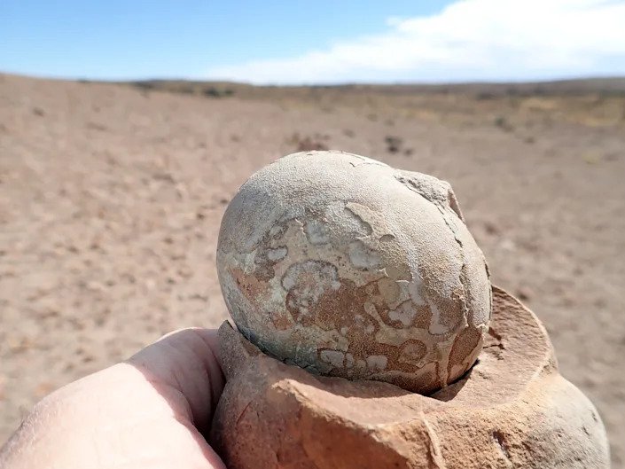
X-rays offer a peek into fossilized dinosaur eggs
A fossilized Mussaurus egg that’s more than 190 million years old, found in southern Patagonia, Argentina.
Argentine paleontologists discovered the first Mussaurus skeletons at this Patagonian site in the late 1970s. The dinosaurs they found were no more than 6 inches long. Unaware that they’d uncovered newborns, the researchers named the creature “mouse lizard” because of the skeletons’ tiny size.
Pol decided to reexplore the area starting in 2002, and by 2013, he’d helped find the first adult Mussaurus fossils there. Those bones revealed that full-grown versions of these “mouse lizards” were closer in size to modern-day hippos. They grew to weigh about 1.5 tons, reaching lengths of 26 feet from nose to tail tip. But infants could fit in the palm of a human hand.
A screen shot from a video showing how scientists like Diego Pol used high-energy X-rays to peek inside a Mussaurus egg without destroying it.
Since then, Pol’s team has also uncovered and studied the contents of the nesting ground, which measures just under half a square mile. In 2017, he took 30 of the eggs to a lab in France, and his group then used X-ray technology to peek inside and confirm the species of the embryos without breaking the shells.
By analyzing the sizes and types of bones in the nesting ground, the researchers determined that the animals were buried near counterparts of a similar age. Some clusters had juveniles less than a year old, others consisted of individuals that were slightly older but not yet fully grown, and finally, there were smatterings of adults that had died solo or in pairs.
That type of age segregation, the researchers said, is a key sign of herds: Juveniles hung out with others their age while adults looked for food and protected the community.
“They were resting together and likely died during a drought,” Pol said. “This is compatible with a herd that stays together during many years and within which the animals get close to each other to rest, or to forage, or do other daily activities.”
Another strong indication of herd behavior is a nesting ground itself: If Mussaurus lived as a community, it would make sense that they’d lay eggs in a common area.
Living in herds may have helped Mussaurus survive
Nest with Mussaurus eggs dated to more than 190 million years ago, found in Patagonia. Diego Pol
To figure out the fossils’ ages, researchers examined minerals in volcanic ash that was scattered around the eggs and skeletons, and determined that the fossils were about 193 million years old.
Previously, scientists thought this type of dinosaur lived during the late Triassic period, about 221 million to 205 million years ago. But the new date suggests instead that Mussaurus thrived during the early Jurassic period. That, in turn, is evidence that Mussaurus’ ancestors survived a mass extinction event 200 million years ago.
The key to that survival, the study suggests, may have been their herding behavior.
“These were social animals and we think this may be an important factor to explain their success,” Pol said.
An artist’s depiction of the nesting ground of a Mussaurus herd of in what is now Argentina.
Communal living likely helped Mussaurus find enough food, perhaps by making it easier for them to forage over larger areas. Mussaurus of the same size would likely “group together to coordinate their activities,” Pol said, given that larger adults and tinier juveniles moved at different speeds.
He added that given the size difference between newborns and adults, it probably took these dinosaurs many years to reach full size. So young Mussaurus might have been vulnerable to predation.
By staying in herds, adults could better protect their young.