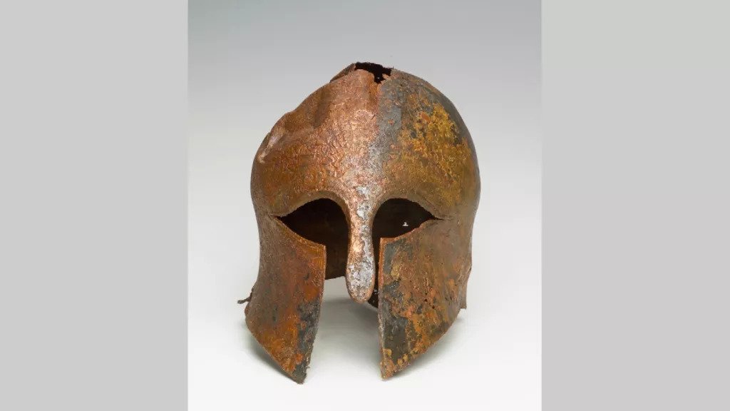
All posts by Archaeology World Team

The Hasanlu Lovers and their 2800 years-old kiss

The Hasanlu Lovers and their 2800 years-old kiss

Archaeologists were shocked to discover the remains of two bodies, apparently sharing a romantic embrace before their deaths, in the ruins of an ancient, burned-out village.

The Hasanlu Lovers.

The University of Pennsylvania first discovered this skeletal couple during an archaeological excavation of an ancient city in northwest Iran in the 1970s. The two skeletons were discovered in the remains of the ancient city of Teppe Hasanlu, which stood in the area that is now Iran 2,800 years ago.

These remains were found in a mudbrick bin, designed for storing grain, embracing one another in what appears to be a kiss and were dubbed “The Hasanlu Lovers.”

From archaeological evidence, researchers discovered that the city of Teppe Hasanlu was destroyed around 800 BCE by an invading army that sacked the city and burned it to the ground.

In addition to the Hasanlu Lovers, human remains from hundreds of others from the time, men, women, and children were found strewn across the city streets of Hasanlu. The people of this city, it appears, were completely wiped out by the invading raiders.

Other bodies found at Teppe Hasanlu.

The Hasanlu Lovers were likely hiding from these invaders in the grain bin when they died of asphyxiation from the smoke emanating from the fires raging around the city.

The Urartu Kingdom of the Armenian highlands is believed to have been responsible for this slaughter.

While the media and public were quick to decide that the two people locked in this embrace were a man and woman in a romantic relationship, archaeologists responsible for the find note that the relationship and gender between the two remain unclear.

One of the “lovers,” the one laying on his back, is definitively a young male (18-22), due to his pelvic shape and dental structures. The sex of the second “lover” is much more under question.

It is unclear what the sex of the “touching” person truly was. While researchers were easily able to identify the age of the person these remains belonged to, 30 to 35, the gender remains a mystery as the skeleton has both male and female features.

The site of Teppe Hasanlu today.

Given the forensic evidence we have, it is more likely that the second body was that of a man as well.

When this evidence was first revealed in the 1980s, reporters flocked to report that the Hasanlu Lovers were gay. However, the relationship between these two ancient people, whether one was male or female, is entirely unknown.

While these two men could have been lovers, many hypothesize that the older person was, in fact, the father of the boy. If the skeleton is in fact female, then it could easily also be his mother.

Furthermore, “gay” and “straight” as discreet identities and orientations are a product of modern society, not labels that can be applied to people in the distant past.

While ancient people engaged in sex with members of the opposite gender and their own, these sexual preferences did not bring with them the same social identities that we associate with them today.

So while these intertwined skeletons from thousands of years ago maybe a stirring image, we should not assume to understand the complexities of their lives and social systems from a single snapshot.

Fossil Found of Ancient Four-Legged Whale that Could Walk on Land

Fossil Found of Ancient Four-Legged Whale that Could Walk on Land

The four-legged creature above resembles an otter or a platypus at first glance. In fact, it’s a 42.6 million-year-old whale with a length of 13 feet. In a new study published in the journal Current Biology, palaeontologists have documented their discovery of this whale ancestor, whose skeleton was unearthed in Peru in 2011.

An artistic reconstruction of two individuals of Peregocetus, one standing on the rocky shore of modern-day Peru and the other preying on fish. The existence of a tail fluke remains hypothetical.

Named Peregocetus pacificus, which means “the travelling whale that reached the Pacific” in Latin, this recent finding is upending scientists’ understanding of how these creatures evolved and spread around the world millions of years ago.

“This is the first indisputable record of a quadrupedal whale skeleton for the whole Pacific Ocean,” study co-author Olivier Lambert said in a press release.

This ancient whale could walk and swim

Peregocetus had four legs, with small hooves of the tips of its fingers and toes. That adaption, along with the orientation of its hip and leg bones, suggests this whale ancestor could maneuver on land.

Its tail and webbed feet, however, indicate that Peregocetus could swim well, too, much in the same way modern-day otters do. So Lambert and his colleagues categorized the creature as amphibious (meaning it lived partially in water and partially on land).

But that doesn’t mean the animal was good at walking, and “certainly not at running,” according to the Los Angeles Times. It likely ate in the water and only took to solid ground for activities like breeding and giving birth, Lambert told the LA Times.

Palaeontologists uncovered the animal’s bones just inland of Peru’s western coast at a site called Playa Media Luna, a three-hour drive south of Lima.

They excavated the whale’s tail vertebrae, jawbones, some of its spine, and it’s front and hind limbs. The animal’s skeleton suggests it was just over 13 feet long, and there’s evidence it had a pronounced snout filled with sharp teeth for chomping on fish.

Peregocetus’ tail bones appear similar to those of beavers and otters, suggesting that the limb played a large role in swimming, the authors wrote.

Unfortunately, the bones from the tip of Peregocetus’ tail were missing, so the researchers weren’t able to determine whether it had a well-developed tail fluke (like modern whales have) to help propel it through the water.

Whales’ new evolutionary story

Scientists agree that today’s massive, flippered whales evolved from small, four-legged ancestors in south Asia more than 50 million years ago. Fossils from one of the oldest quadrupedal whales that lived 53 million years ago were discovered in India.

The ancient creatures likely migrated west from Asia to Africa and then swam across the Atlantic until they hit the shores of the Americas.

Until now, palaeontologists thought these ancient whales had only made it to North America and hadn’t strayed south.

This is the first time a whale ancestor with four legs has been found in South America. And according to the study authors, Peregocetus might also be the oldest quadrupedal whale found in the Americas.

Whale ancestors with four legs are ample in the North American fossil record. Researchers found a 41.2 million-year-old whale ancestor off the shores of South Carolina in 2014. This led scientists to hypothesize that amphibious whales likely reached North America after leaving Africa’s western shores.

But the discovery of Peregocetus – which is 1.4 million years older than the South Carolina fossil – in Peru suggests that the animal may actually have arrived in South America before spreading to North America.

Schematic drawings depict the skeleton of Peregocetus in walking and swimming stance. Solid lines indicate the main preserved bones, while dotted lines indicate reconstructed parts.

So the study authors suggest that, contrary to previous ideas, Peregocetus and other whale ancestors likely traveled from Africa to South America. The distance between those was far smaller during the era in which Peregocetus lived – a period called the middle Eocene – than it is today. At the time, the distance between South America and Africa was about half of what it is today.

During the Eocene, North and South America were also separated by ocean, which created a channel from the Atlantic to the Pacific Ocean. So the researchers now think that four-legged whales sliced through this gap between the Americas, then traveled north.

Earth has Another Continent Called Zealandia – Only 6% of it is Above Water

Earth has Another Continent Called Zealandia – Only 6% of it is Above Water

A map of New Zealandia, outlined in gray.

About 3,500 feet under the south Pacific waves sits a lost eighth continent.

In 2017, scientists reported that the underwater landmass known as Zealandia was a different continent. However, they hadn’t been able to trace it in its entirety before now. GNS Science in New Zealand revealed that they had created an unparalleled map of the continent’s shape and scale. Users could digitally navigate the continent by using their maps on an interactive website.

“We’ve made these maps to provide an accurate, complete, and up-to-date picture of the geology of the New Zealand and southwest Pacific area — better than we have had before,” Nick Mortimer, who led the work, said in a statement.

Mortimer and his colleagues mapped the bathymetry surrounding Zealandia — the shape and depth of the ocean floor — as well as its tectonic profile, showing where Zealandia falls across tectonic-plate boundaries.

The maps reveal new information about how Zealandia formed before it became submerged underwater millions of years ago.

An underwater continent nearly 2 million square miles in size

Zealandia’s area is nearly 2 million square miles (5 million square kilometres) — about half the size of Australia.

But only 6% of the continent is above sea level. That part underpins New Zealand’s north and south islands and the island of New Caledonia. The rest is underwater, which makes Zealandia challenging to survey. To better understand the submerged continent, Mortimer and his team mapped both Zealandia and the ocean floor around it. The bathymetric map they created (below) shows how high the continent’s mountains and ridge rise toward the water’s surface.

A bathymetric map of New Zealandia, which shows the shape of the continent under the water.

It also depicts coastlines, territorial limits, and the names of major undersea features. The map is part of a global initiative to map the planet’s entire ocean floor by 2030.

The second map the GNS scientists made (below) reveals the types of crust that make up the underwater continent, how old that crust is, and major faults. The continental crust — the older, thicker kind of Earth’s crust that forms landmasses — is shown in red, orange, yellow, and brown. The oceanic crust, which is generally younger, is in blue. Red triangles show where volcanoes are.

A tectonic map of New Zealandia, which shows the types and age of the crust, major faults, and volcanoes that make up the continent.

This map also reveals where Zealandia sits across various tectonic plates, which of those plates are being pushed under the other in a process known as subduction, and how quickly that movement is happening. Studying the tectonic machinations that underpin Zealandia today can reveal clues about how the continent formed in the first place.

Zealandia’s 85 million-year-old origins

The concept of Zealandia is 25 years old. Geophysicist Bruce Luyendyk coined the term in 1995.

Luyendyk previously told Business Insider that he never intended for the term to describe a new continent. Rather, the name originally referred to New Zealand and a collection of submerged chunks of crust that broke off the ancient supercontinent Gondwana about 85 million years ago.

“The reason I came up with this term is out of convenience,” Luyendyk said. “They’re pieces of the same thing when you look at Gondwana. So I thought, ‘Why do you keep naming this collection of pieces as different things?'”

Gondwana formed when Earth’s ancient supercontinent, Pangea, split into two fragments. Laurasia in the north became Europe, Asia, and North America. Gondwana in the south dispersed to form modern-day Africa, Antarctica, South America, and Australia.

A map of Pangea 200 million years ago, with tectonic plate boundaries in white.

Geologic forces continued to rearrange these landmasses, and Zealandia was forced under the waves about 30 million to 50 million years after it broke off Gondwana as the largest tectonic plate — the Pacific Plate — slowly subducted beneath it.

These maps show Zealandia is a continent like the other 7

Until 2017, Zealandia was classified as a “microcontinent,” as the island of Madagascar. But according to Mortimer, Zealandia ticks all the boxes for continent status: It has clearly defined boundaries, occupies an area greater than 386,000 square miles (1 million square kilometres), is elevated above the surrounding ocean crust, and has a continental crust thicker than that oceanic crust.

These new maps, therefore, offer further evidence that the underwater landmass should be considered the eighth continent, Mortimer added.

“If we could pull the plug on the world’s oceans, it would be quite clear that Zealandia stands out,” he told Science News in 2017, adding, “If it wasn’t for the ocean level, long ago we’d have recognized Zealandia for what it was — a continent.”

14,000-year-old ice age village discovered is 10,000 years older than the pyramids

14,000-year-old ice age village discovered is 10,000 years older than the pyramids

In their oral history, the Heiltsuk people describe how the area around Triquet Island, on the western coast of their territory in British Columbia, remained open land during the ice age.

“People flocked there for survival because everywhere else was being covered by ice, and all the ocean was freezing and all of the food resources were dwindling,” says Heiltsuk Nation member William Housty.

And late last year, archaeologists excavating an ancient Heiltsuk village on Triquet Island uncovered the physical evidence: a few flakes of charcoal from a long-ago hearth.

Analysis of the carbon fragments indicates that the village site — deserted since a smallpox epidemic in the 1800s — was inhabited as many as 14,000 years ago, making it three times as old as the pyramids at Giza, and one of the oldest settlements in North America.

“There are several sites that date to around the same time as the very early date that we obtained for Triquet Island, so what this is suggesting is that people have been here for tens of thousands of years,” says Alisha Gauvreau, a scholar at the Hakai Institute and a PhD candidate at the University of Victoria, who has been working at the Triquet Island site.

But how was it that Triquet Island remained uncovered, even during the ice age? According to Gauvreau, sea levels in the area remained stable over time, due to a phenomenon called sea level hinge.

“So all the rest of the landmass was covered in ice,” she explains. “As those ice sheets started to recede — and we had some major shifts in sea levels coastwide, so further to the north and to the south in the magnitude of 150 to 200 meters of difference, whereas here it remained exactly the same.”

The result, Gauvreau says, is that people were able to return to Triquet Island repeatedly over time. And while nearby sites also show evidence of ancient inhabitants, people “were definitely sticking around Triquet Island longer than anywhere else,” she says. In addition to finding bits of charcoal at the site, she says archaeologists have uncovered tools like obsidian blades, atlatls and spear throwers, fishhook fragments and hand drills for starting fires.

“And I could go on, but basically, all of these things, coupled with the fallen assemblage, tell us that the earliest people were making relatively simple stone tools at first, perhaps expediently, due to the parent material that was available at the time,” Gauvreau says.

The site also indicates that these early people were also using boats to hunt sea mammals, and gather shellfish, she adds. And later on, they traded or travelled great distances to obtain nonlocal materials like obsidian, greenstone and graphite for tools.

For archaeologists and anthropologists, the find bolsters an idea, called the “Kelp Highway Hypothesis” hypothesis, proposing that the first people who arrived in North America followed the coastline in boats to avoid the glacial landscape.

“It certainly adds evidence to the fact that people were able to travel by boat in that coastal area by watercraft,” Gauvreau says.

And for the Heiltsuk Nation, which has worked with the archaeologists for years to share knowledge and identify sites like Triquet Island, the updated archaeological record provides new evidence, as well. The nation routinely negotiates with the Canadian government on matters of territory governance and natural resource management — negotiations that depend in part on the community’s record of inhabiting the area over long periods.

Archaeologists at the site are unearthing tools for lighting fires, fish hooks and spears dating back to the Ice Age

“So when we’re at the table with our oral history, it’s like me telling you a story,” Housty says. “And you have to believe me without seeing any evidence.”

But now, he explains, with the oral history and archaeological evidence “dovetailing together, telling a really powerful tale,” the Heiltsuk have new advantages at the negotiating table.

“That’s really going to be very significant … and I think will definitely give us a leg up in negotiations, for sure,” he says.

Rabbits Uncover 9,000-Year-old Artifacts on a Welsh island

Rabbits Uncover 9,000-Year-old Artifacts on a Welsh island

A group of rabbits inadvertently uncovered a hoard of 9,000-year-old Stone and Bronze Age artefacts hidden on the small Welsh island of Skokholm this month, in a first-of-its-kind discovery.

Skokholm Island typically allows a select number of visitors to spend the night, but COVID-19 lockdowns have reduced its population to only two wardens — and a bunch of rabbits.

Skokholm Island sits in the Celtic Sea to the west of mainland Wales and is two miles off the Pembrokeshire coast. It is currently only inhabited by two wardens, seabird experts Richard Brown and Giselle Eagle, who made the startling discoveries.

According to The Guardian, Brown and Eagle were making their usual patrol of the area when they discovered an artefact at the entrance of a rabbit burrow right by the island’s cottage.

Rabbits Uncover 9,000-Year-old Artifacts on a Welsh island
The discoveries were made at the same rabbit burrow which was apparently dug into an ancient hunter-gatherer site.

The wardens sent pictures of the piece to experts on the mainland, who identified it as a Mesolithic tool.

The tool was what researchers call a “beveled pebble,” and has since been estimated to be around 6,000 to 9,000 years old. Experts believe it was used by Stone Age hunter-gatherers to craft boats out of seal hides as well as to prepare foods like shellfish.

According to Andrew David, an expert who examined the prehistoric tool virtually, similar items have been found at coastal sites nearby, including Pembrokeshire and Cornwall, but this is a historic first for Skokholm Island.

However, the discoveries didn’t stop there.

This particular tool is believed to have been used to prepare shellfish and bolster ancient watercraft with animal skin.

Indeed, just a day later, Brown and Eagle spotted the second round of items at the entrance to the same rabbit burrow which included yet another Mesolithic-era stone tool and sizable pieces of pottery.

The wardens sent photos of these to the curator of prehistoric archaeology at the National Museum of Wales, Jody Deacon. She identified the pottery pieces as relics from a 3,750-year-old burial urn from the Early Bronze Age.

One particularly large fragment was found to have come from a rather thick pot. It was decorated with lined incisions, leading Deacon to conclude that it was likely used for cremation rituals.

For Toby Driver, an archaeologist at the Royal Commission of Wales, the discoveries ultimately suggest that the island’s cottage was built atop an ancient burial site which itself was built on top of an even older site.

“Skokholm is producing some amazing prehistoric finds,” he said. “It seems we may have an early Bronze Age burial mound built over a middle Stone Age hunter-gatherer site. It’s a sheltered spot, where the island’s cottage now stands and has clearly been settled for millennia.”

Experts believe this pottery fragment belonged to a funerary urn, an artefact never before found on Skokholm Island.

Finding prehistoric burial earns in Wales isn’t all that unusual. Discovering them on Skokholm, meanwhile — or on any of the western Pembrokeshire islands — is unprecedented.

Brown and Eagle, who moved to Skokholm Island in 2013, are helping to uncover more about the island’s ancient past.

While it’s barely a mile long and half a mile across, Skokholm Island has a fascinating history. The name itself is Norse, given by the Vikings who settled there in the late 10th or early 11th century. Then, Skokholm became a rabbit farm around the 15th century.

In 2006, the Wildlife Trust of South and West Wales purchased the isle in order to conserve it as a national nature reserve. While it’s typically open for a restricted number of visitors to spend the night, the coronavirus pandemic has left Brown and Eagle on their lonesome and documenting their observations on a blog.

These miraculous discoveries might lend some credence to the age-old superstition that rabbit’s feet bring luck.

Experts are eager to find out for themselves, with a fresh, exhaustive survey of Skokholm Island later this year. However, they will have to wait until pandemic lockdowns are lifted.

A farmer discovers an Ice Age cave hidden under his field that is over 11,000 years old

A farmer discovers an Ice Age cave hidden under his field that is over 11,000 years old

A farmer discovered an Ice Age cave that was naturally formed and used by humans. Adam Bryczek had been roaming his land near the town of Kraśnik in south-eastern Poland when he came across what appeared to be a large hole.

But what had originally been a small opening in the ground, had widened over time, before ultimately collapsing.

Startled Bryczek found the opening led down around 10 metres into an underground cave with an area of a few dozen square metres and a maximum height of up to around 140 cm – not enough for most adults to stand upright.

The cave is a few dozen square metres wide with a maximum height of around 140 cm – not enough for most adults to stand upright.

Bryczek reported his find to Dominik Szulc, the guardian of monuments in Kraśnik County, in January.

Since then, the site has been visited by archaeologists from Lublin, the capital of the region.

The underground space appears to be a solutional cave, which means that it was formed by the bedrock being dissolved by groundwater.

According to Szulc: “The cave undoubtedly dates back to the Pleistocene (2.58 million – 11,700 years ago), and more precisely, perhaps the so-called glaciations of the Nida or San (730,000-430,000 years ago).”

During this period, a Scandinavian ice sheet covered the Lublin Upland and the local area was covered by a thick layer of snow, he explains.

During temporary increases in temperature, there was a lot of flowing water, which dissolved the limestone rock, forming the walls, floor and ceiling of the cave.

Even though the cave formed naturally, the researchers point out that it was visited by humans, apparently to extract stone for building.

The cave’s walls show traces of mechanical work left by tools.

In a post on Facebook, Szulc did not publish the cave’s exact location, warning that it could be dangerous.

He wrote: “It is not suitable for access to visitors, because it is too small and low, with a steep and dangerous entrance leading to it.”

Experts are now working on a way to secure the cave so that people can enter it again to conduct scientific research.

Amazing Heart-Shaped Amethyst Geode Discovered by Miners in Uruguay

Amazing Heart-Shaped Amethyst Geode Discovered by Miners in Uruguay

Beautiful gemstones that have been transformed to take on different shapes adorn several items of jewelry. However, the natural amethyst geode discovered by these miners did not need any processing. That’s because it already seems to be fine!

In its latest Santa Rosa mine near the Uruguay-Brazil border, Uruguay Minerals recently discovered a rare heart-shaped natural amethyst geode. Workers were able to separate a hard-to-break rock, and that’s when they found a pair of purple and white hearts embedded on either side of it.

“It was a normal day at our mine located in the Catalan area in Artigas. The workers were just now allowed in the area to find more geodes in the new mine,” Marcos Lorenzelli of Uruguay Minerals recalled of that fateful day.

“We were opening the mine to work normally but the land was difficult to work and our employees said, ‘We have to find something really nice due to the hard work we are doing.’” he told Modern Met.

The workers had no idea how true that statement would be, considering that they were struggling to get the excavation going because of the harder-than-usual basalt in the area.

Amazing Heart-Shaped Amethyst Geode Discovered by Miners in Uruguay

But after two to three hours of non-stop toiling, the miners cracked open a rock using their excavator machine, and it revealed the most precious treasure inside.

Surely, this geode took many, many years to form, and it’s amazing to think how Mother Nature has managed to create such beauty. And these miners were the lucky ones to unearth it!

Geodes come in all shapes, colours, and sizes, but Uruguay Minerals has never found something quite like this before.

“This is very unique and it’s the first time we found something like this,” Lorenzelli said.

Extremely proud of its recent discovery, the company quickly shared photos of the heart-shaped geode on its website and social media pages.

The rare geode caught the internet by storm as photos of it went viral. On Reddit, a picture of two miners holding rocks bearing the heart geodes have earned 116K upvotes on the platform. Over 1.2K have engaged in the comments.

Here are some of the people’s reactions to this extraordinary natural amethyst geode.

“I wouldn’t mind betting that this started because someone carved a heart into a rock many decades ago.”

“Wow! That’s amazing!!! I love this! A few of my favourite things…. rocks, purple, hearts.”

“No way that’s amazing. I love Amethyst and that piece is definitely a gift from Mother Earth. Others took the discovery as a reminder to take care of our natural resources.

“Make a choice to love the earth back!”

Uruguay Minerals transforms its geodes into different shapes, including hearts, angels, wings, and Christmas trees. The brand sells its creations through its website, including this heart-shaped one, which they’ve named “The New Treasure.”

Unlike its other products, the brand left “The New Treasure” untouched because of how naturally beautiful it looks.

Archaeology breakthrough: Second ‘hidden pyramid’ discovered inside iconic Mayan structure

Archaeology breakthrough: Second ‘hidden pyramid’ discovered inside iconic Mayan structure

Archaeologists have confirmed that the massive Kukulkan pyramid in eastern Mexico – one of the most iconic pyramids in the world – was built like a Russian nesting doll, with the discovery of two smaller pyramids hidden within its walls.

The first of the hidden pyramids was discovered back in the 1930s, built within the walls of the colossal Kukulkan tomb. Now an even smaller pyramid has been found inside that one – and the discoveries might not stop there. 

“To make matters more complicated, the third Russian doll moving in may actually be one of a set of several small dolls rattling around inside the same shell.

Ancient Mayan pyramid in Chichen Itza

We just do not know,” anthropologist Geoffrey Braswell from the University of California, San Diego, who was not involved in the study, told The Associated Press. Built sometime between the 9th and 12th centuries, the Kukulkan pyramid is the centrepiece of the vast Chichen Itza complex in the Mexican state of Yucatán. 

Also known as El Castillo (meaning “the castle”), this colossal pyramid features 364 steps – one for every day of the year in the Maya calendar system – and stands 24 metres (79 feet) tall. A 6-metre-high (20-foot) temple sits on top of the pyramid and was dedicated to the featured serpent god, Kukulkan.

Back in 1931, archaeologists began investigating the insides of the pyramid, with suspicions that it could be hiding the remains of a much older version – something that was widely disbelieved at the time.

Over the course of the next five years, they discovered a room nicknamed the hall of offerings, containing a giant Chacmool statue, its nails, teeth, and eyes inlaid with mother of pearl.

They also found a room called the chamber of sacrifices, containing two carefully arranged rows of human bones, and an elaborate red jaguar statue, encrusted with 74 jade inlays for spots, and jade-studded eyes.

The researchers soon realised that there was a larger, much older pyramid hidden below and inside the Kukulkan pyramid, and it stands roughly 33 metres tall (108 feet).

Now, archaeologists have completed their latest investigation of that internal pyramid using a non-invasive imaging technique called tri-dimensional electric resistivity tomography, and report the discovery of a 10-metre-tall (33-foot) pyramid hidden inside the larger two.

At this stage, it’s not clear if this the same structure archaeologists detected back in the 1940s but couldn’t confirm – or something else entirely.

Oddly enough, it appears to have been built above a water-filled sinkhole called a cenote, which researchers detected under the Kukulkan pyramid just last year. 

It’s not clear if the Maya knew of the cenote themselves, but the fact that the pyramids were built directly on top of it, and that Kukulkan was a god of water (among other things), suggests that maybe they did.

“The structure that we have found, the new structure, is not completely in the centre of the Kukulkan pyramid. It is in the direction where the cenote is,” Rene Chavez Segura, from the National Autonomous University of Mexico, told CNN.

“This could either confirm or hypothesise that the Mayans when they built this structure that they knew of the existence of this cenote.”

According to Segura and his team, the smallest pyramid was likely built between 550 and 800 AD. The middle structure has between 800 and 1000 AD, while the outer one was finished between 1050 and 1300 AD.

The researchers are yet to publish their findings, so these dates and the pyramid’s structure will still need to be verified by independent teams, but it’s hoped that further investigations will continue, so we can figure out if there are even more pyramids hidden inside.

“If this could be investigated in the future, this structure would be significant, because it would speak to the first few periods of habitation of the site and would provide information about how the settlement developed,” Denisse Argote from Mexico’s National Institute of Anthropology and History told CNN.