1,600-Year-Old Elongated Skull with Stone-Encrusted Teeth Found in Mexico Ruins
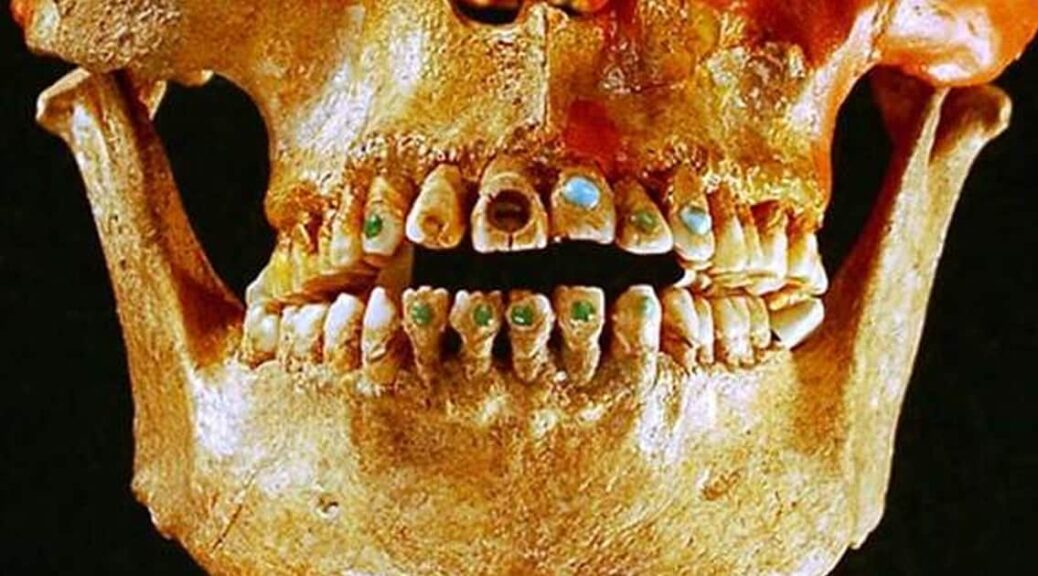
The 1600-year-old skeleton of an upper-class woman whose skull was purposely deformed and teeth encrusted with mineral stones was found by archeologists near ancient Teotihuacan ruins of Mexico.
Archeologists who found the 1,600-year-old skeleton near Mexico’s ancient Teotihuacan said the woman was 35-40 when she died with intentionally deformed skull and teeth encrusted with mineral stones
When she died, between the ages of 35 and 40, the woman was buried with 19 jars that served as offerings, the National Anthropology and History Institute said.
The institute said in a statement that her cranium had been elongated by being compressed in a “very extreme” manner, a technique commonly used in the southern part of Mesoamerica, not the central region where she was found.
Her teeth contained two round pyrite stones, which were encrusted in her top front teeth.
This was a practice that was used among the nobility in Maya regions in southern Mexico and Central America.
The Maya are credited with being the masters of cosmetic dentistry as they were known to decorate teeth by embedding them with precious stones or by carving notches and grooves into them.
Tiny holes were chipped out of teeth and ornamental stones—including jade—were attached with an adhesive made out of natural resins, such as plant sap, which was mixed with other chemicals and crushed bones.
The dentists likely had a sophisticated knowledge of tooth anatomy because they knew how to drill into teeth without hitting the pulp inside.
Gold studded teeth, Pre-Columbian Ecuador.
Last year, archaeologists discovered liquid mercury in a subterranean tunnel beneath the Temple of the Feathered Serpent in Teotihuacan, which may represent an underworld river that leads the way to a Royal tomb or tombs.
The remains of the kings of Teotihuacan, some of the most powerful rulers of the pre-Hispanic world, have never been found.
Such a discovery would be monumental as it would unravel many of the mysteries surrounding this ancient civilization.
The enigmatic pre-Hispanic city of Teotihuacan, some 50 kilometers (30 miles) north of Mexico City, thrived between the first and eighth centuries, after which its civilization vanished.
Its two majestic Sun and Moon pyramids are major tourist attractions.
The 1,600-year-old skeleton of an upper-class woman found near Mexico’s ancient Teotihuacan wore a prosthetic lower tooth made of a green stone known as serpentine
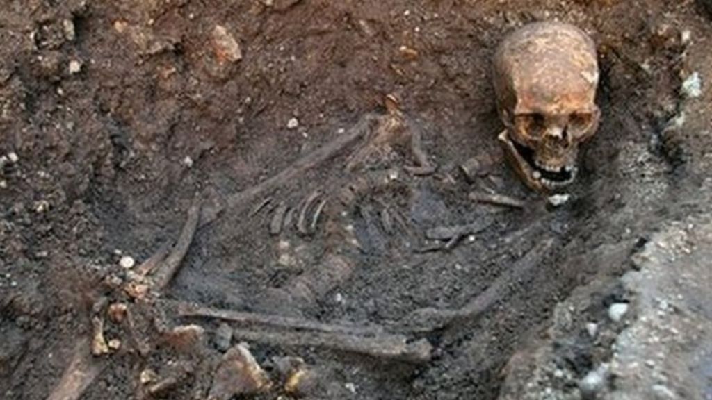
Archaeologists found a skeleton under a car park in the city of Leicester. The remains were believed to be Richard III
Experts from the University of Leicester said DNA from the bones matched that of descendants of the monarch’s family. Lead archaeologist Richard Buckley, from the University of Leicester, told a press conference to applause: “Beyond reasonable doubt it’s Richard.”
The earliest surviving portrait of Richard III in Leicester Cathedral. Archaeologists are hoping to find his grave under a council car park in Leicester.
Richard, killed in battle in 1485, will be reinterred in Leicester Cathedral. Mr. Buckley said the bones had been subjected to “rigorous academic study” and had been carbon-dated to a period from 1455-1540.
Dr. Jo Appleby, an osteo-archaeologist from the university’s School of Archaeology and Ancient History, revealed the bones were of a man in his late 20s or early 30s. Richard was 32 when he died. His skeleton had suffered 10 injuries, including eight to the skull, at around the time of death. Two of the skull wounds were potentially fatal.
One was a “slice” removing a flap of bone, the other was caused by a bladed weapon that went through and hit the opposite side of the skull – a depth of more than 10cm (4ins).
‘Humiliation injuries’
Dr Appleby said: “Both of these injuries would have caused an almost instant loss of consciousness and death would have followed quickly afterwards.
“In the case of the larger wound, if the blade had penetrated 7cm into the brain, which we cannot determine from the bones, death would have been instantaneous.”
Other wounds included slashes or stabs to the face and the side of the head. There was also evidence of “humiliation” injuries, including a pelvic wound likely to have been caused by an upward thrust of a weapon, through the buttock. Richard III was portrayed as deformed by some Tudor historians and indeed the skeleton’s spine is badly curved, a condition known as scoliosis.
However, there was no trace of a withered arm or other abnormalities described in the more extreme characterisations of the king.
Missing princes
Without the scoliosis, which experts believe developed during teenage years, he would have been about 5ft 8ins (1.7m) tall, but the curvature would have made him appear “considerably” shorter.
Dr Appleby said: “The analysis of the skeleton proved that it was an adult male but was an unusually slender, almost feminine, build for a man.
“Taken as a whole, the skeletal evidence provides a highly convincing case for identification as Richard III.”
Richard was a royal prince until the death of his brother Edward IV in 1483. Appointed as protector of his nephew, Edward V, Richard instead assumed the reins of power. Edward and his brother Richard, known as the Princes in the Tower, disappeared soon after. Rumors circulated they had been murdered on the orders of their uncle.
Challenged by Henry Tudor, Richard was killed at Bosworth in 1485 after only two years on the throne.
DNA trail
He was given a hurried burial beneath the church of Greyfriars in the center of Leicester. Mr. Buckley said the grave was clumsily cut, with sloping sides and too short for the body, forcing the head forward.
“There was no evidence of a coffin or shroud which would have left the bones in a more compact position.
“Unusually, the arms are crossed and this could be an indication the body was buried with the wrists still tied,” he added. Greyfriars church was demolished during the Reformation in the 16th Century and over the following centuries, its exact location was forgotten.
However, a team of enthusiasts and historians managed to trace the likely area – and, crucially, after painstaking genealogical research, they found a 17th-generation descendant of Richard’s sister with whose DNA they could compare any remains. Joy Ibsen, from Canada, died several years ago but her son, Michael, who now works in London, provided a sample.
The researchers were fortunate as, while the DNA they were looking for was in all Joy Ibsen’s offspring, it is only handed down through the female line and her only daughter has no children. The line was about to stop.
Tomb plans
But the University of Leicester’s experts had other problems. Dr. Turi King, project geneticist, said there had been concern DNA in the bones would be too degraded: “The question was could we get a sample of DNA to work with, and I am extremely pleased to tell you that we could.”
She added: “There is a DNA match between the maternal DNA of the descendants of the family of Richard III and the skeletal remains we found at the Greyfriars dig.
“In short, the DNA evidence points to these being the remains of Richard III.” In August 2012, excavation began in a city council car park – the only open space remaining in the likely area – which quickly identified buildings connected to the church. The bones were found in the first days of the dig and were eventually excavated under forensic conditions.
The spot (circled in red) where archaeologists found the remains of the 15th century monarch
The final resting place of Richard III? A body matching his description was found here buried in a shroud
Details of the reburial ceremony have yet to be released, but Philippa Langley from the Richard III Society said plans for a tomb were well advanced. She said of the discovery of Richard’s skeleton: “I’m totally thrilled, I’m overwhelmed, to be honest, it’s been a long hard journey. I mean today as we stand it’s been nearly four years.
“It’s the culmination of a lot of hard work. I think, as someone said to me earlier, it’s just the end of the beginning.
“We’re going to completely reassess Richard III, we’re going to completely look at all the sources again, and hopefully there’s going to be a new beginning for Richard as well.”
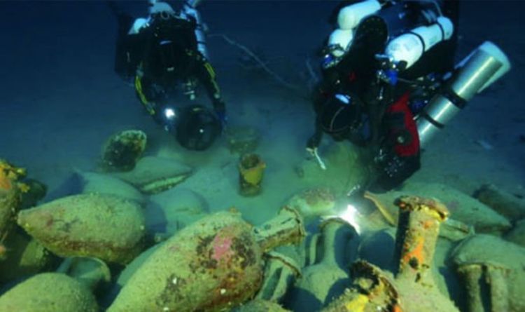
Archaeology breakthrough: How 2,000-year-old Roman shipwreck discovery ‘redefined’ history
Scuba researchers explored waters in Florida when they came across the shipwreck of a Roman vessel. The ship was called ‘Panarea III,’ and was expected to have sailed between Rome and Carthage about 218-210 AD during the Second Punic War.
In 2010 US archeologists using sonar equipment and a remotely operated submersible find it at 130 meters depth.
In the center of the researchers, the Italian archeologists considered that the ship was a supply vessel in the fleet of the Roman consul Marcus Claudius Marcellus.
Among the stunning artefacts were “small fishing plates, kalathoi, pitcher, and the louterion,” the archaeologists said.
They said the latter was probably used as a sacrificial altar on board the ship.
Jarrod Jablonski, one of the divers, added: “Metal supports still embedded in the base were likely used for fastening to the deck.
Underwater researchers were exploring waters in Florida when they came across the shipwreck of a Roman vessel.
“The Louterion (the ship) is one of many unique discoveries that promise to help redefine what we understand about ancient trade routes and commerce in the 3rd century BC.”
A similar discovery was made in the waters of the Mediterranean when a Phoenician vessel was found by researchers.
The Phoenicians were the direct descendent of the Canaanites of the south Syrian and Lebanese coast – known as a great maritime people who had developed a high level of shipbuilding technology.
It was found at a depth of 125 metres below the surface.
According to Science News, after they find, Dr. Gambin said: “This shipwreck may offer new and significant information about Phoenician seafaring and trade in the central Mediterranean during the archaic period.
“To date, little is known about the earliest contact of Phoenician mariners with the Maltese islands.”
The researchers claimed that the ship was sailing from Sicily to Malta when it sank.
It was about 15 metres long and carried a cargo of 20 grinding stones (about 35 kg each) and 50 amphorae of seven different types – indicating the ship had been indifferent harbours.
Archaeology news: They believe the ship was from Sicily
Dr. Gambin added: “This discovery may be considered as one of the best-preserved archaeological sites in Malta datable to the early Phoenician period.”
3500-year-old Ancient Egyptian stone chest could lead archaeologists to a royal tomb
The stone artifact also contains a wooden chest engraved with the name of Thutmose II, a famous boy Pharaoh who took the throne aged just 13.
Discovered at the ancient site of Deir el-Bahari, the extraordinary find indicates an untouched royal tomb may be hidden nearby.
Several packages wrapped in linen canvas were found inside the box. One contained the goose and another held the egg of a bird known as an ibis.
Professor Andrzej Niwiński, from Warsaw University, told the Polish Press Agency: “The chest itself is about 40 cm long, with a slight smaller height.
“It was perfectly camouflaged, looked like an ordinary stone block. Only after a closer look did it turn out to be a chest.”
Several packages wrapped in linen canvas (top left) were found inside the chest. One contained the goose and another contained the egg of a bird known as an ibis. One package contained a wooden box (bottom left and top right)
Encased inside the stone chest was a wooden box wrapped in four layers of canvas.
Within this box was a second box in the shape of a chapel. It featured one of the names of Pharaoh Thutmose II.
Thutmose II was married to the famous Queen Hatshepsut. It’s thought he took the throne in his early teens and reigned for just three years before his death aged 16.
Archaeologists made the extraordinary find at the famous Egyptian site of Deir el-Bahari. It’s not clear how or why the goose was sacrificed.
It’s a vast complex of temples and tombs located on the west bank of the Nile, opposite the city of Luxor, Egypt.
Based on the artefacts’ symbolism and engravings, Professor Niwiński said he had high hopes of finding a hidden royal tomb somewhere nearby the burial.
“The royal deposit implies that a temple or a tomb was erected for the king here,” he said.
Mortuary temple of Queen Hatshepsut, Dayr al-Bahri, Egypt, c1457 BC. Archaeologists announced the discovery of a stone chest and a bundle in Dayr al-Bahri that could lead to the discovery of a royal temple
“And because we are in the middle of a royal cemetery, there is no doubt that it must be a tomb.
“The discovery of this deposit suggests that we are in the process of finding a tomb.”
The stone chest discovery was made in March last year but only made public this month.
Archaeologists continued their work in October 2019 but are yet to find an entrance to a secret tomb.
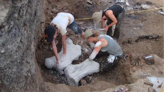
Ice Age Graveyard Discovered Containing 22 Giant Sloths Preserved In Their Own Feces
A surprising find was made in Ecuador by paleontologists – a group of giant Ice Age sloths.
The 22 sloths of elephants, from the ice age, were found as fossilized. Paleontologists made the grand discovery preserved in asphalt during a dig at the Tanque Loma site in the Santa Elena peninsula, western Ecuador.
The fossils of the Panamerican ground sloths, known as Eremotherium laurillardi, were spotted during this dig.
Paleontologists excavating the site reported stumbled-upon bones belonging to 15 adults, five juveniles, and two newborns or foetuses of the mammoth creatures.
Experts believe these creatures roamed the Earth in modern-day Ecuador some 20,000 years ago.
Elephant-like in size, the sloths may have weighed several tonnes. The ancient animals also boasted the impressive ability to walk on two legs. This is unlike their current incarnations who walk the Earth today.
Experts unearth fossilised remains of 22 elephant-sized sloths
Elephant-like in size, the sloths may have weighed several tonnes
Palaeontologist Jose Luis Roman-Carrion of the National Polytechnic University in Ecuador said: “The Tanque Loma site presents a rare accumulation of fossils that provides very relevant data.
“We now know that the Eremotherium lived in groups and had parental behaviour.”
The fossils were likely so well preserved because they had been coated in seeping asphalt. The mammoth sloths were discovered alongside an ancient horse, a deer, an armadillo-like pampathere, and an elephant-like gomphothere.
Experts remain unable to determine the exact cause of death simply by looking at the fossilized bones. However, researchers believe the deaths may have resulted from drought or illness caused by drinking water contaminated with their own faeces.
A lifesize depiction of mammoths stuck in tar is on display at the La Brea Tar Pits in Los Angeles.
The University of California, Los Angeles palaeontologist Dr Emily Lindsey, led the study of the sloth fossils.
Dr. Lindsey explained to Gizmodo: “For years, everyone has thought of the classic scenario at the La Brea Tar Pits, where a large herbivore would get stuck in asphalt, then a bunch of carnivores would be attracted to the trapped animal and get stuck.
“Nothing got stuck at Tanque Loma! The animals died in an aquatic setting like many other fossil sites, and the bones just fortuitously got preserved by seeping asphalt.”
The news arrives almost exactly two years after a similarly amazing ancient sloth discovery. A fossilised human footprint was found nestled inside a giant sloth footprint in April 2018.
Experts now believe the series of surprisingly well-preserved set of tracks describe the story of an ancient sloth hunt.
This was because inside the outline of the sloth’s 20-inch-long foot was a human footprint. There were at least 10 of these tracks, all lined-up in a row.
Professor Matthew Bennett of Bournemouth University said in a statement: “It slowly dawned on me what was happening.
“Thousands of years ago, a ground sloth had walked along with this site, and a person had followed it, carefully matching its every step.
The remains of a giant sloth depicted climbing a tree at the Natural History Museum in London.
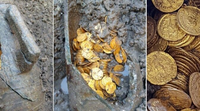
In mint condition! Millions of pounds-worth of pristine 5th-century gold coins are found buried in a pot under an Italian theatre.
It was an amphora, not a pot, but archaeologists found a literal jackpot in a dig in northern Italy last week. No word on if there was a rainbow. Hundreds of gold coins dating from Rome’s late Imperial era, the 4th or 5th century, were found at a dig in Como, Italy, according to the Italian Ministry of Culture.
Hundreds of gold coins dating to the 4th or 5th centuries were found in an archaeological dig in Como, Italy.
The ministry shared photos of the shiny coins, which were spilling out of an amphora — a Roman jar with two handles — buried in the dirt.
Inside was an estimated 300 gold coins from the late Roman Imperial era, which took place in the 5th century, just before the empire’s untimely demise. Despite their age, the coins are in miraculous condition, with all the images and engravings easily visible.
“We do not yet know in detail the historical and cultural significance of the find,” said Alberto Bonisoli, the culture minister of Italy’s Ministry of Cultural Heritage and Activities (Ministero per I Beni e le Attività Culturali) in a press release.
“But that area is proving to be a real treasure for our archaeology. A discovery that fills me with pride”.
A priceless stash of fifth-century gold coins has been found buried in a pot under an Italian theatre
Archaeologists digging on the former site of the Cressoni Theatre in Como were stunned to discover them
The urn and its stash of gold were taken to a government restoration laboratory in Milan, where they will be thoroughly examined. This might take a while, however, as the coins were found tightly packed into little stacks so that they can only be removed one at a time with careful precision.
So far, historians have successfully separated 27 coins, all of which are from the 5th century. This makes this treasure particularly intriguing, as, during this time, there was very little currency flow in the Roman economic system.
The coins feature engravings that suggest they were minted during the reigns of five different emperors: Honorius, Valentinian III, Leon I, Antonio, and Libio Severo.
The Italian media has predicted that the coins, none of which reach beyond 474 AD, could be worth millions of euros. And that doesn’t even take into account everything that was found in the urn, or the urn itself.
Keeping the coins company was a bar of gold, and at the bottom of the urn, archaeologists predict even more precious objects might be found.
According to The History Blog, “no such hoard has even been unearthed in northern Italy before”.
The archaeological site may seem like an odd place to stash such valuable items, but whoever placed them there likely “buried it in such a way that in case of danger they could go and retrieve it.” That’s according to Maria Grazia Facchinetti, an expert in rare coins. Beyond the location, the way that the coins were hidden has given historians like Facchinetti a few hints about the owner’s identity.
“They were stacked in rolls similar to those seen in the bank today,” she says.
“All of this makes us think that the owner is not a private subject, rather it could be a public bank or deposit”.
Facchinetti’s theory is bolstered by the fact that the theatre is just a few steps away from the city’s forum – a place where merchants, banks, and temples often did business.
Although the ancient Roman neighborhood was also known for its wealth, so a miserly and paranoid private owner is not out of the question. Layer analysis will now be used to determine if the coins were all deposited in the same era or if they were placed in the urn over a period of time.
The Cressoni Theatre, where the coins were found, is not far from the ancient city of Novum Comum, home to many other important Roman artifacts. The historic theatre was opened in 1807 but was converted into a cinema that closed in 1997.
Today, the plan is to demolish the old building and replace it with luxury residences. The recent discovery, however, has stalled all future work at the site until further excavations can be made.
Mt. Vesuvius Eruption Exploded Skulls And Vaporized Bodies, Roman Archaeologists Find
More than two million people visit Pompeii every year and hundreds of thousands visit the ruins of Herculaneum, the second city buried by the eruption of Vesuvius in August 79 AD.
It was not much longer than 24 hours for the volcanic eruption. Thousands of people have died, as many exactly know no one.
Certainly, in Pompeii only about 1000 bodies have been found and in Herculaneum only 300 bodies. But Pompeii had more than twenty thousand men, Herculaneum about 4000. Where are the others? Well, many could have fled.
There are reports of survivors. Others may have died on the run. There are excavations only in Pompeii and Herculaneum, not in the surrounding area.
Whoever made it out of the city, but was killed by a stone from the volcano, for example, has probably not been found until today. The layers with the material from the eruption are 5 to 25 meters deep.
Corpses in Pompeii
Since the 1870s, during the Excavations Pompeii, when a cavity was found, a plaster cast was made.
The bodies were filled with ashes during the volcanic eruption. Later the bodies rotted. What remained was a hollow space. If you filled it with plaster, you got an exact 3D image of the former man. There are also such plaster figures of animals that lived in Pompeii.
In Pompeii, visitors can see such plaster people. They are surprisingly accurate, even in detail. You can see the position of the body at death. We even thought we could see fear and pain in some faces.
The plaster cast method also has disadvantages. Possible remains such as bones of ancient people can no longer be examined.
Nevertheless, many plaster casts have been carefully examined by scientists. For example, it was found that in ancient times almost all people had very good teeth, no tooth decay, or the like. This is probably due to the nutrition, there were hardly any sweets except honey at that time.
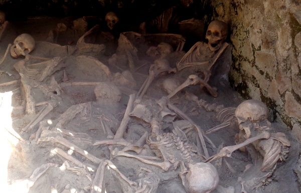
Corpses in Herculaneum
In Herculaneum, however, many skeletons were discovered. Several hundred people found refuge in stable, small buildings in the lower part of the city on the former shore of the sea. Here they died of hot ashes, toxic gases, and heat.
Some of the skeletons are still there as they were found. Visitors to Herculaneum see many remains of people in each of the small buildings. One mother even had a baby in her arms.
These bodies have been examined in recent years using state-of-the-art methods. DNA analysis and other methods have provided many new insights.
It was surprising that almost all corpses were well nourished. Almost everyone ate fish and meat. A young woman was probably a vegetarian, even that existed in antiquity.
At present, there are some projects which investigate the human, antique excrement from the sewage of Pompeii and Herculaneum. Here, too, there are some new things, for example concerning the nutrition of the people of that time.
For many visitors of Pompeii, the plaster casts of the people are a highlight during the visit of the excavation. In the Excavation Herculaneum, the skeletons in the lower area are certainly a highlight.
Trunks of Fake Artifacts from the Middle East Seized at Heathrow
A number of objects confiscated by authorities and allegedly originating from the old Middle East have been described as fake. In July 2019, the Border Force intercepted a couple of trunks loaded with individually wrapped clay tablets, figures, and pots at Heathrow airport.
The fake figurines were fired in a modern kiln instead of under the sun
The clay tablets had illegible cuneiform inscriptions on them
The freight was sent from Bahrain and bound for a UK address. Inside, a collection of clay tablets, figurines, cylinder seals, and animal-shaped pots were uncovered. As many as 190 tablets were also packaged inside.
However, experts in the Department of the Middle East at the British Museum have since classified the entire ‘trove’ as forgeries.
The collection of fakes will now be used by the museum for training purposes, though some will go on display for a brief time when the British Museum reopens.
‘These seizures confirm an emerging trend: capitalizing on interest in the purchase of antiquities, unscrupulous traders are faking Middle Eastern objects for sale,’ said John Simpson, curator at the British Museum.
Suspicions were first raised about the collection seized by Border Force by the Department of the Middle East.
The team said the collection appeared ‘to represent an almost complete range of basic items known from ancient Mesopotamia,’ according to a Press Association report.
The haul was seized at Heathrow Airport and British Museum experts examined the articles
Specifically, the collection included cushion-shaped school texts to be held in one hand and written on one side. It also contained prisms and cylinders for burial as building inscriptions and administrative texts, votive mace-heads, and inscribed dedicatory wall cones.
There was also a royal inscription that mentioned the late Assyrian king Adadnirari.
They also found a mathematical tablet, and an inscribed amulet resembling a unique example dug up at the Assyrian capital of Nimrud.
However, the cuneiform inscriptions were found to be a jumble of signs which made no sense.
Museum experts also discovered the clay used in most items was of a similar type, impossible in genuine articles – and they had all been fired in a modern kiln, rather than authentically sun-dried.
The tablet dimensions also did not match the originals, a common forgery error when working from photographs.
‘These consignments confirm the importance of vigilance on the part of our law enforcement agencies and the role that museums need to play in the identification of these objects,’ said Simpson.