3,000 Skeletons Found During London Railway Construction
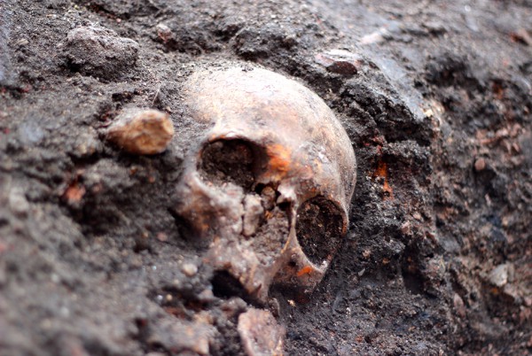
Approximately 3,000 skeletons, some dating back to the 1500s, have been discovered and are being excavated as part of the construction of a new train station being built near London.
They came from every parish of London, and from all walks of life, and ended up in a burial ground called Bedlam. Now scientists hope their centuries-old skeletons can reveal new information about how long-ago Londoners lived—and about the bubonic plague that often killed them.
Archaeologists announced that they have begun excavating the bones of some 3,000 people interred in the 16th and 17th centuries, who now lie in the path of the Crossrail transit line. They will be pored over by scientists before being reburied elsewhere.
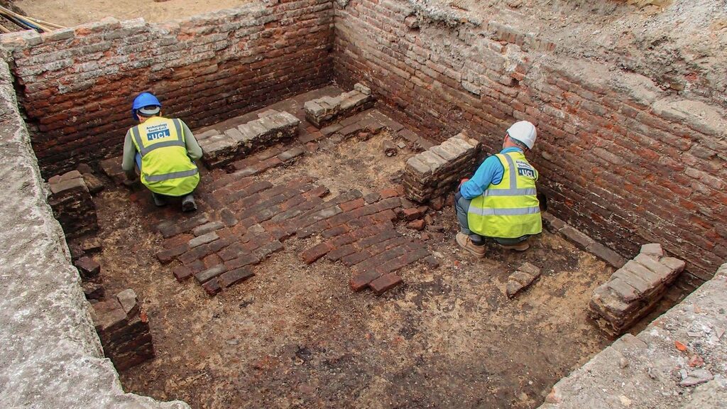
One recent workday, just meters (yards) from teeming Liverpool Street railway station, researchers in orange overalls scraped, sifted, and gently removed skeletons embedded in the dark earth. In one corner of the site, the skeleton of an adult lay beside the fragile remains of a baby, the wooden outline of its coffin still visible. Most were less intact, a jumble of bones and skulls.
“Part of the skill of it is actually working out which bones go with which,” said Alison Telfer, a project officer with Museum of London Archaeology, which is overseeing the dig.
Due to open in 2018, the 118-kilometer (73-mile) trans-London Crossrail line is Britain’s biggest construction project and its largest archaeological dig for decades. The central 21-kilometer (13-mile) section runs underground, which has meant tunneling beneath some of the oldest and most densely populated parts of the city.
For Londoners, that has brought years of noise and disruption, but for archaeologists, it’s like Christmas. Almost every shovelful of the earth has uncovered a piece of history, or prehistory: bison and mammoth bones; Roman horseshoes; medieval ice skates; the remains of a moated Tudor manor house.


Chief archaeologist Jay Carver says the Bedlam dig could be the most revealing yet.
“It’s going to be archaeologically the most important sample we have of the population of London from the 16th and 17th centuries,” Carver said.
Bedlam cemetery opened in 1569 to take the overspill as the city’s churchyard burial grounds filled up. It is the final resting place of prosperous citizens and paupers, religious dissenters including the 17th-century revolutionary Robert Lockyer and patients from Bedlam Hospital, the world’s first asylum for the mentally ill. The hospital’s name, a corruption of Bethlehem, became a synonym for chaos.
Tests on the bones by osteologists may reveal where these Londoners came from, what they ate, and what ailed them—which in many cases was the plague. There were four outbreaks of the deadly disease over the two centuries the cemetery was in use, including the “Great Plague” that killed 100,000 people in 1665.
Carver says researchers will analyze DNA taken from the pulp in the skeletons’ teeth to help fill in the “evolutionary tree of the plague bacteria.”
The technique was used to discover the plague bacterium, Yersinia pestis, in 14th-century skeletons excavated at another Crossrail site, identifying them as victims of the Black Death that wiped out half the city’s population in 1348.

Scientists should be able to compare the bacterium found in Bedlam’s plague victims with the 14th-century samples, helping to understand whether the disease—which still infects several thousand people a year—has evolved over the centuries.
Sixty archaeologists working in shifts—16 hours a day, six days a week—will spend about a month removing the remains. After the scientific study, they will be reburied on Canvey Island in the Thames Estuary—the latest in a long line of Londoners to move east out of the congested city.
The old burial ground will be the site of a new train station, whose users will probably give little thought to the history beneath their feet.
But Telfer says she never forgets that these fragile bones were once living, breathing individuals.
“When you are doing something like this, you do feel a connection with them,” she said. “I think you have a responsibility to treat them with great respect. It’s quite a special process.”