Category Archives: EUROPE

Possible Grave of Medieval Christian Hermit Excavated in Spain

Possible Grave of Medieval Christian Hermit Excavated in Spain

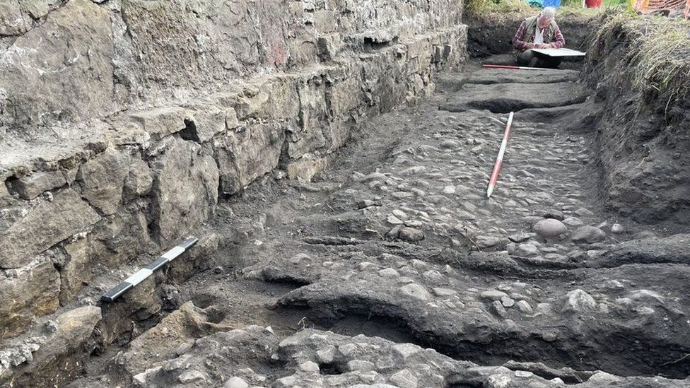
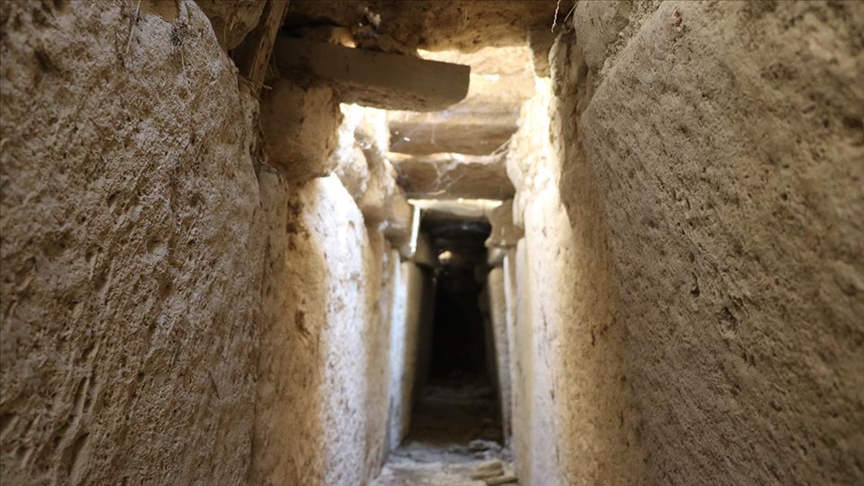
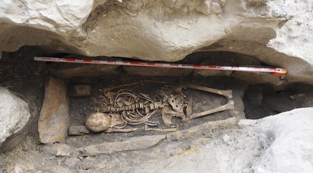
This summer, a tomb embedded in the rock by the main entrance to the San Tirso and San Bernabé Hermitage situated in the karst complex of Ojo Guareña (Merindad de Sotoscueva, Burgos) was excavated; its structure of slabs holds the skeleton of an adult individual in the supine position, with its head to the west, set between two small limestone blocks.

Possible Grave of Medieval Christian Hermit Excavated in Spain
Hispano-Visigothic tomb in Ojo Guareña.

This excavation was prompted by the new chronologies offered by the dating project for the Ojo Guareña Karst Complex Cultural Heritage (2017–2021).

One of the dates obtained in 2020 evinces a Hispano-Visigothic period chronology related to the transition between the end of the seventh century and the start of the eighth, while the human remains from the lower level are associated with a transition phase between the end of the eighth century and the start of the ninth, in the High Middle Ages.

“In both cases, these push the evidence known to date for the start of Christian worship at this emblematic site back several centuries,” says Ana Isabel Ortega, an archaeologist attached to the Fundación Atapuerca and the Centro Nacional de Investigación sobre la Evolución Humana (CENIEH).

The anthropological studies, especially the analyses of stable isotopes of hydrogen, carbon and strontium, together with the dating for the remains, offer us a glimpse into the life of this person, who could have been associated with the first hermits who sought a retreat in this idyllic setting where they could live in isolation, during centuries of great turbulence linked to the arrival of the Moors, just as was the case elsewhere close to the upper course of the River Ebro and its tributaries in the south of the province of Cantabria, the north of Burgos, Álava and La Rioja.

Apart from Ortega, the excavation team was made up of Pilar Fernández, Sofía de León and Raquel Lorenzo, restorers at the CENIEH, and Miguel Ángel Martín.

The other collaborators were Aitor Fernández, an employee of the Ayuntamiento de Merindad de Sotoscueva, as well as Clara López, Alberto Gómez and Eduardo Sainz Maza, who are guides to the San Bernabé Cave. Josu Riezu and Txus Riezu also furnished their support.

Once the excavation has concluded and the human remains have been recovered, these will be consolidated and restored at the CENIEH.

They will subsequently be subjected to dating, morphometric and paleopathological studies, while Ana Belén Marín and Borja González, researchers from the EvoAdapta R+D+i Group at the Universidad de Cantabria, will participate in isotopic studies.

Hub of Christianity

San Bernabé Cave became a hub of Christianity during the High Middle Ages as a centre for religion and pilgrimage, with the foundation of a church devoted to San Tirso and San Bernabé in a process that appropriated the former pagan sanctuary in the Ojo Guareña karst enclave caves, intimately bound up with the process that gave rise to the Kingdom of Castile.

Three Phases of Wooden Wagon Way Uncovered in Scotland

Three Phases of Wooden Wagon Way Uncovered in Scotland

BBC News reports that three layers of wooden tracks constructed for the horse-drawn Tranent Waggonway have been uncovered in East Lothian by researchers from the 1722 Waggonway Project.

Three Phases of Wooden Wagon Way Uncovered in Scotland
The 1722 Waggonway Project said the early railway was unique in archaeology

The Tranent Waggonway in East Lothian was first constructed in 1722.

It was initially built for hauling coal from a pit at Tranent to Cockenzie and Port Seton for use as fuel in a process for making salt.

New archaeological excavations have revealed three wooden railways, each one laid immediately on top of the last.

The 1722 Waggonway Project said it appeared to have been an attempt to upgrade the railway with “crudely cut timbers” over a short period of time.

The gauge – the distance between the two rails – was also changed from an initial 3ft 3in (about one metre) in the first phase to 4ft (1.2m) in the second and third phases.

The project team said there was no other site like it in railway archaeology.

Its research has identified the three phases of upgrades happening between 1722-25, 1728-30 and 1743-44.

The second phase was described as “extremely well constructed”, with cobbles laid to form a track between the rails for the horses that pulled the waggons.

The new excavations were done this year

Railway historian Anthony Leslie Dawson said: “Whilst we know these railways had a limited lifespan due to their method of construction, to see this process of continual replacement and upgrade – including a change of gauge – in the archaeological record is outstanding.

“The waggonway excavation has shown that these waggonways are far more complex than the single-phase structures previously excavated, and the survival of timber on-site including joints helps us further understand the construction of these early railways.”

The project’s archaeologists also excavated a salt pan building in Cockenzie, and discovered evidence of use of the site in the production of salt lasted from 1630 to about 1780.

This Ancient Underground City Was Big Enough to House 20,000 People

This Ancient Underground City Was Big Enough to House 20,000 People

Chicago, like a lot of other modern cities, has a hidden secret: It’s home to miles of passageways deep underground that allow commuters to get from one place to another without risking nasty weather.

This Ancient Underground City Was Big Enough to House 20,000 People
Illustration of the underground maze-like ancient city beneath Cappadocia.
The Cappadocia landscape with its tuff towers.

Los Angeles, Boston, New York, and Dallas all have their own networks of underground tunnels, as well. But there’s a place in Eastern Europe that puts those forgotten passages to shame. Welcome to Derinkuyu — the underground city.

A Subterranean Suburb

Picture this. It’s 1963, and you’re on a construction crew renovating a home. You bring your sledgehammer down on a soft stone wall, and it all crumbles away, revealing a large, snaking passageway so long that you can’t see where it ends.

This is the true story of how the undercity at Derinkuyu was (re-)discovered. While those workers knew they’d found something special, they couldn’t know just how massive their discovery had been.

Stretching 250 feet (76 meters) underground with at least 18 distinct levels, Derinkuyu was a truly massive place to live. Yes, live. There was room for 20,000 people to stay here, complete with all of the necessities (and a few luxuries) — freshwater, stables, places of worship, and even wineries and oil presses.

Circular stones were used to seal access to passageways.

It isn’t the only underground city in the area known as Cappadocia, but it’s the deepest one we know of, and for many years, it was believed to be the largest as well. (Another recently discovered location may have been home to even more people.)

Derinkuyu and the other 40-ish underground cities nearby are made possible thanks to the prevalence of tuff in the area, a kind of volcanic rock that solidifies into something soft and crumbly. That makes it relatively easy to carve enormous subterranean passages — but why would you want to? The answer lies in the cities’ origins.

Defense Against the Sword Arts

Derinkuyu isn’t exactly inhospitable on the surface level (after all, that’s where the people who found it were living). So why did ancient people decide to build their living quarters below the surface? Because they weren’t hiding from the broiling sun or annual meteor showers.

They were clearly hiding from invading forces, with massive, rolling stone doors to block off each floor should any armies breach the fortress. But who were the people of the caves, and who were they defending themselves against? The answer to the second question depends on the answer to the first.

The earliest known people to live in the area were the Hittites, who ruled the Turkish Peninsula from about the 17th to 13th centuries B.C.E. — well over three millennia ago.

Some scholars point to artefacts with Hittite cultural elements, such as a small statue of a lion, found in the underground caves. That suggests these ancient people would have been taking refuge from invading Thracians.

A 55-meter (180-ft) shaft used a primary well at Derinkuyu.

If they were, it didn’t work forever: A tribe of Thracians, the Phrygians, conquered the area next. It’s possible that the Hittites never lived underground, however; an alternate theory says that it was the Phrygians, not the Hittites, who spawned the subterranean city.

Since the construction of many of the large underground complexes is dated to some time between the 10th and 7th centuries B.C.E., and the Phrygians lived there until the 6th century B.C.E., they’re generally regarded to have created the first caves. In that case, they may have been hiding from the Persian host under Cyrus the Great that eventually did take over the region.

Lost and Found

The Persians would have used those caves as well, as would all of the people to come after. Eventually, according to some sources, early Christians around the 2nd century C.E. took root in the caves as they fled Roman persecution.

This pattern continued throughout the centuries and millennia to come — in fact, Greek Christians were still using the caves as late as 1923. It’s pretty incredible, then, that the caves would have been forgotten in the 40-odd years between their last residents and their “re-discovery.”

It’s more likely, then, that it wasn’t the caves themselves, but the extent of the caves that were forgotten. While the holes burrowed into the area’s fairy chimneys would have been obvious even from a distance, it’s likely that the people living in more modern accommodations never realized that the caves in the wilderness outside of the urban area reached 18 stories down.

Divers Just Found Four 2,200-Year-Old Roman Battering Rams Used During The Punic Wars

Divers Just Found Four 2,200-Year-Old Roman Battering Rams Used During The Punic Wars

An Ancient Roman battering ram was used to end the First Punic War.

The First Punic War, fought between Ancient Rome and Carthage for supremacy over the western Mediterranean, began in 264 B.C. It was the most prolonged naval conflict in antiquity. For 23 years on the seas from Sicily to North Africa, warships clashed with their battering rams — four of which have just been found.

Each of these colossal artefacts was made of bronze and weighed 450 pounds. Formerly fitted to the bows of Roman warships, they tore into the enemy vessels of Carthage at the Battle of the Aegates on March 10, 241 B.C. The fight was so brutal that it ended the First Punic War in a single day.

After thousands of years on the seafloor, these ancient weapons of war were finally retrieved from wrecks off the coast of Sicily, where the battle took place.

The retrieval effort was conducted by the U.S. RPM Nautical Foundation and Sicily’s Marine Archaeology Unit, and the find has shed new light on the wars of antiquity.

Historical accounts indicate Ancient Rome sank up to 50 Carthaginian ships with these rams, which held three enormous blades that ripped into the wooden hulls of enemy ships.

The three blades on each side were used to tear through enemy hulls.

That feat of engineering was one of the main reasons for Rome’s emerging victorious from the war.

The newly-retrieved Roman rams all bore inscriptions from judges that affirmed these weapons were made in accordance with the high Roman engineering standards.

Carthaginian battering rams, meanwhile, commonly held inscriptions dedicated to Baal, a deity worshipped for its control of the weather, suggesting they put their faith in gods instead of builders. Valeria Livigni of the Marine Archaeology Unit confirmed that the Carthaginian rams were “less well made than the Roman rams.”

That wasn’t the only revelation, however. Now, previous beliefs about Rome’s naval strategies have been challenged. While accounts have long indicated that both parties had about 200 ships, with Rome sinking 50 enemy vessels and capturing 70 while losing only 30 ships, their attacks are now being reassessed.

“We believed that ships tried to ram each other broadside,” said David Ruff of the RPM. “But many of the rams we have discovered are damaged, suggesting they went head to head. Either way, these were very violent collisions.”

The site of the Battle of Aegates was only identified in 2010.

Historians believe that Romans would toss both their masts and anchors overboard during an approach and row their now lighter vessels into a Carthaginian ship. Their enemies, meanwhile, commanded far heavier ships with payloads meant to be offloaded at the Mediterranean ports of Drepena and Lilybaeum.

The site of the Battle of Aegates was only identified in 2010 when a fisherman spotted a battering ram below his boat and notified Italian archaeologist Sebastiano Tusa. Earlier this summer, divers discovered three merchant vessels that held more than 200 ceramic jars, with some still containing traces of wine.

The Battle of the Aegates was first recorded by Greek historians Polybius and Diodorus. It began as a fight over the control of Sicily. With Rome encroaching on the town of Drepana, Carthage took to the seas to defend itself under the command of Hannibal’s son Hanno against Roman forces led by Praetor Quintus Valerius Falto.

The battering rams weigh 450 pounds each and the blades are two feet long.

While Rome lost a few dozen ships and saw 50 more damaged, their maneuverability allowed for more complex approaches than their enemy.

Colliding into Carthaginian ships with lighter vessels and greater speeds saw Hanno’s weighty fleet suffer immense losses before it could pick up reinforcements from shore.

The Roman warships easily encircled their slower enemies before ramming right into their hulls, casting the Carthaginian sailors into the seas and watching their vessels sink.

The sheer slaughter saw any remaining Carthaginian ships flee home. Hanno was crucified for his disastrous loss in battle.

Carthage sued for peace and signed the Treaty of Lutatius, which forced them to give up Sicily and pay enormous reparations. And although the First Punic War was over, there were still two more to come, and the battle for the dominance of the Mediterranean wouldn’t end for almost another 100 years.

Remarkably, it was only a few months ago that divers uncovered an Ancient Greek military vessel nearby. While this latest diving team uncovered Ancient Roman warships, it seems the Mediterranean has a lot left to offer historians — and is sure to broaden our understanding of ancient naval warfare for years to come.

Mysterious stone balls made 5,500 years ago were discovered on the island’s ancient tomb

Mysterious stone balls made 5,500 years ago were discovered on the island’s ancient tomb

Mysterious stone balls made 5,500 years ago were discovered on the island's ancient tomb
One of the polished stone balls was found in a Neolithic tomb on Tresness in the Orkney Islands. Hundreds of such balls have been found but no one knows what they were used for.

Two polished stone balls shaped about 5,500 years ago — linked to a mysterious practice almost unique to Neolithic Britain — have been discovered in an ancient tomb on the island of Sanday, in the Orkney Islands north of mainland Scotland.

Hundreds of similar stone balls, each about the size of a baseball, have been found at Neolithic sites mainly in Scotland and the Orkney Islands, but also in England, Ireland and Norway, Live Science previously reported.

Some are ornately carved — such as the famous Towie ball discovered in northeast Scotland in 1860 — but others are studded with projections or smoothly polished.

Early researchers suggested that the balls were used as weapons, and so they were sometimes called “mace heads” as a result. Another idea is that rope could have been wound around the lobes carved into some of the balls to throw them.

Archaeologists Reveal Medieval Saint’s Hut on Scottish Island
Archaeologists have found evidence that the remains of a hut on the island of Iona date to the late sixth century A.D., the exact period when Saint Columba lived and worked at the site. Credit: University of Glasgow.

But most archaeologists now think the stone balls were made mainly for artistic purposes, perhaps to signify a person’s status in their community or to commemorate an important phase of their lives, said archaeologist Vicki Cummings of the University of Central Lancashire in England, who led the excavations of the tomb on Sanday.

The two stone balls found at the tomb near the beach at Tresness on Sanday — one made of black stone and the other of lighter-coloured limestone — are very early examples of such objects and were smoothly polished, rather than being carved like the Towie ball. Carving balls tended to happen later in the Neolithic period, she said, while polishing balls was generally an earlier practice.

The two polished balls “are much simpler, but they are still beautiful objects,” Cummings told Live Science. “They would have taken quite a long time to make because it is quite time-consuming to polish a stone … You’ve got to sit there with some sand and some water and a stone, and basically put the work in.”

Neolithic tomb

The tomb was built about 5,500 years ago when the coast was much further away. It’s now in danger of being damaged by a storm.

This is one of the few times that stone balls have been found in their true archaeological context, Cummings said, which could shed light on the purpose of the mysterious objects. Each of the balls was found in the corners of two different compartments used to inter human remains in the burial chamber of the tomb, while other objects — especially pieces of pottery — were found along the compartment walls.

“Probably what was happening was that people were putting little slabs down and putting pots on top of these slabs,” Cummings said. “They really seemed to be interested in the walls and the corners.”

Inside the tomb, archeologists also found a deposit of cremated human bones near the entrances of two of the five compartments in the burial chamber, as well as several “scale knives,” which were made by breaking beach pebbles into flakes that had a sharp edge.

“You can use it as a really good butchery tool — and we found tons of those in the [tomb], which is really surprising. And that begs the question of what they [the makers] were up to,” Cummings said.

People may have used knives to separate the flesh from the bones of the dead. “It might suggest they were manipulating the human remains that were placed in the chamber — there are many traditions and lots of examples of that,” she said.

Ancient islands

The Orkney Islands are beyond the very northernmost tip of mainland Scotland. They are dotted with archaeological sites, including a UNESCO World Heritage Site, called the Heart of Neolithic Orkney around the Ness of Brodgar complex and the Neolithic village at Skara Brae, which suggests the islands were well-populated about 5,000 years ago. 

“The Orkney Islands might seem remote when you look at a map, but when you come here you see they are incredibly rich agricultural land that’s very easy to work,” Cummings said. “I think Neolithic people got here and were really successful — they found an environment that they just thrived in.”

The excavations on Sanday have been a joint effort between the University of Central Lancashire team, led by Cummings, and archaeologists from the National Museums Scotland led by Hugo Anderson-Whymark. The ancient tomb is near the coast and is vulnerable to being disturbed by a storm at sea, so the researchers are trying to find out as much as possible before the site is damaged, Cummings said.

The tomb and a Neolithic settlement they’ve excavated about a mile (1.6 kilometres) away would have been farther from the coast about 5,500 years ago, and the landscape would have had more trees than it does now, she said.

Although the tomb was investigated in the 1980s, only superficial excavations were made that didn’t reveal its old age. During the latest excavations, which took about four years to conclude, the researchers applied the latest archaeological techniques to the tomb, including making a three-dimensional photogrammetric model of it, Cummings said.

The archaeologists will now conduct analyses of the data gathered during the excavations, she said, which hopefully will provide even more information about the Neolithic people of the islands.

Netherlands: They rebuild the face of the first Dutch Neanderthal

Netherlands: They rebuild the face of the first Dutch Neanderthal

You can now gaze into the crinkly eyes of “Krijn,” a young Neanderthal man who had a tumour growing on his skull when he died up to 70,000 years ago.

In 2001, an amateur palaeontologist found a piece of Krijn’s skull while sifting through sediments collected from the bottom of the North Sea, off the coast of the Netherlands.

Now, paleo-anthropological artists have used that hunk of the skull to create a lifelike bust of Krijn, including the bulge above his right eyebrow where the tumour sat. 

“Luckily, it’s a very distinctive piece,” Adrue Kennis, a paleoanthropological artist with Kennis & Kennis Reconstructions, said of the skull specimen in a translated video created by the National Museum of Antiquities (RMO) in the Netherlands, which is showing Krijn’s bust in a new exhibit.

When Krijn was alive, between 70,000 and 50,000 years ago, he lived in Doggerland, a vast swath of land between the United Kingdom and continental Europe, which is now submerged beneath the North Sea.

A 2009 study in the Journal of Human Evolution revealed a few details about Krijn: The young man was highly carnivorous, but his body didn’t show any evidence of seafood in his diet, according to an analysis of the isotopes, or element variants, of carbon and nitrogen found in his skull.

Moreover, a lesion above Krijn’s eyebrow indicated that he had a tumour known as an intradiploic epidermoid cyst.

These cysts are uncommon, slow-growing lesions that are usually benign, especially when they’re small, as Krijn’s is, the 2009 study found. The conduction is associated with a slew of symptoms.

It’s possible that Krijn experienced pain and swelling, headaches, dizziness, convulsions, visual problems or seizures, or maybe he was lucky and didn’t have any symptoms, the authors of the 2009 study wrote. That was the first time such a tumour had been documented in Neanderthal remains, they noted.

The Neanderthal skull specimen was found in sediment from the North Sea.
A facial reconstruction of the Neanderthal who lived in Doggerland between 70,000 and 50,000 years ago.

Despite Krijn’s diagnosis, his new bust depicts him with an infectiously happy smile. The Kennis brothers recreated the Neanderthal’s features by relying not only on the skull specimen but also other Neanderthal skulls, as well as previous data on the Neanderthal eye, hair and skin colour.

The new bust is the latest from their studio, which includes other early human recreations, including one of Ötzi the Iceman mummy, who lived about 5,300 years ago in the Alps.

Krijn may be smiling for another reason; he’s the first fossil hominin dating to the Pleistocene epoch (2.6 million to 11,700 years ago) found under seawater and the first recorded Neanderthal in the Netherlands, according to the 2009 study.

A menagerie of animals, including mammoths, lions, woolly rhinoceroses, reindeer and horses used to live on the Doggerland steppe, but it was very cold, meaning that Krijn likely had a challenging life, according to an RMO statement.

In addition to Krijn’s remains, scientists sifting through the North Sea sediments found several middle Paleolithic artefacts, including small hand axes and pointed stones known as Levallois flakes.

The RMO exhibit “Doggerland: Lost World in the North Sea,” which includes Krijn’s bust, is open to the public through Oct. 31. 

Anglo-Saxon Silver Brooch Recovered in England

Anglo-Saxon Silver Brooch Recovered in England

A metal detectorist who found a rare early-medieval silver brooch has said it was his most “incredible” find ever. The Trewhiddle-style brooch found on farmland at Cheddar in Somerset features detailed interlace decorations with animals thought to be peacocks.

Detectorist Iain Sansome said it was “incredible” to think the treasure used as a symbol of wealth and high status was last held 1,000 years ago.

Somerset Council hopes to keep it in the county once it has been valued.

Mr Sansome added in all of his years of metal detecting this find was “in a different league”.

“When I first saw the brooch I wasn’t exactly sure what it was but I knew it was something special,” he said.

“The fact that the last person to handle it was probably someone of extreme importance and high status over 1,000 years ago is just incredible.”

The South West Heritage Trust conducted a follow-up investigation at the find site but no further significant discoveries were made.

Dr Maria Kneafsey from the Portable Antiquities Scheme said early medieval examples of the brooches were “rare”.

“The fact that no further significant objects were found suggests that the brooch was lost or discarded into the water, rather than deliberately buried,” she said.

The disc brooch dates back to between 800 and 900AD was declared as treasure at an inquest held at Taunton Coroner’s Court in August.

Iain Sansome said the find was “incredible”

2,000-year-old Roman sewage system unearthed in southwestern Turkey

2,000-year-old Roman sewage system unearthed in southwestern Turkey

2,000-year-old Roman sewage system unearthed in southwestern Turkey
It reveals Roman architecture, engineering, head of excavation teams says

The Anadolu Agency reports that a Roman-era sewerage system was discovered in southwestern Turkey’s ancient city of Tripolis by a team of researchers led by Bahadir Duman of Pamukkale University. 

The excavation uncovered a 2,000-year-old sewage system in southwestern Turkey.

The Roman-era sewage system, 160 centimetres (5.2 feet) in height and 70 centimetres (2.3 feet) wide were discovered in the ancient city of Tripolis in the Buldan district of the Denizli province, said Bahadir Duman, head of the excavation team and a lecturer at the Archeology Department of the Pamukkale University.

“The gigantic sewage system has dimensions that a person can easily enter and walk in,” said Duman.

Noting that the sewerage system reveals the Roman architecture and engineering, he said: “The difference between the system in Tripolis and the others is that the sewers have been preserved until today.

The main sewage system is one of the rare examples. Thus, it’s important.”