Possible Medieval Road Uncovered Near Bannockburn Battlefield
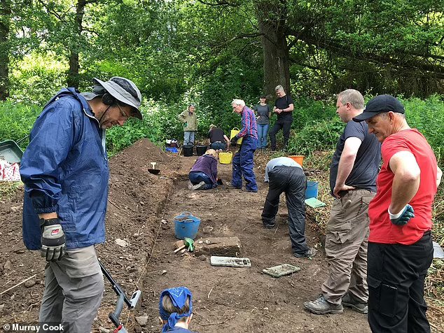
A long stretch of road was uncovered on Saturday during the first-ever dig at Coxet Hill in Stirling. The hill is believed to be where the Scots King Robert the Bruce set up his camp to prepare for the battle ahead of the first day of fighting, on June 23, 1314.
The statue of Robert the Bruce near Bannockburn.
It is also likely to be where the Scottish camp followers and soldiers untrained in Bruce’s tactics were based during the decisive second day when the English army was forced to flee.
These “Sma’ Folk”, concealed by the hill, are said to have emerged once victory was assured to block the line of retreat of King Edward II’s army to Stirling Castle and turned the Scottish victory into a rout.
Stirling archaeologist Dr Murray Cook, who organised the dig to mark the 707th anniversary of the battle, said the stone-built road would have gone around the hill, which was established as a hunting wood for game birds by King Alexander III in the 13th century.
It would have been used by Bruce and his army around the time of the battle, and Dr Cook believes it may also have been the route taken by the Sma’ Folk when they caused panic in the English ranks.
Dr Cook said: “Where we thought we had a boundary around Alexander III’s New Park, it now appears we have a road. We’ve got a 100-metre section of it, probably four metres wide.
The long-hidden thoroughfare skirted around the New Park, a ‘cockshot’ — a hunting wood for game birds established by King Alexander III of Scotland in around 1264. Pictured: the dig site
“This hard-packed stone road or track curves around the bottom of the Coxet Hill and doesn’t show on any of the maps going back the last 200 years, which suggests a medieval origin.
Coxet Hill was also where the sma’ folk — men lacking training or weapons — were held in reserve until the second day, once Bruce’s victory was assured. At this point, they emerged from where they had been concealed to block the line of retreat to Stirling Castle. Pictured: the Battle of Bannockburn as depicted in the 15th century ‘Scotichronicon’, showing Bruce wielding an axe and Edward II fleeing north towards Stirling Castle
“The fact it is around the medieval royal wood suggests it was there before the Battle of Bannockburn and was in use at that time. It is logical that it was used by Robert the Bruce.
“Potentially this was also the route used by the Sma’ Folk on the way to [the Battle of] Bannockburn.”
The Battle of Bannockburn was fought on June 23-24, 1314. King Edward II travelled to Scotland to find and destroy the Scottish army and relieve Stirling Castle, which had been under Scottish siege.
The Battle of Bannockburn between the English army of Edward II and Scottish forces led by Robert the Bruce took place from June 23-24, 1314. Pictured: an interpretation of the first day of the battle, in which the English cavalry formations advanced on the Scots, but were ultimately forced to retreat back south over the Bannockburn
Despite being vastly outnumbered — only 6,000 men made up Bruce’s army — the Scottish proved victorious. Pictured: On the second day of the battle, the Scottish forces surprised the English by emerging from New Park, ultimately hemming Edward II’s forces against the Bannockburn and ultimately driving them to retreat
Edward’s army of up to 25,000 men far outnumbered the force assembled by Robert the Bruce, but the Scots were victorious. After a day of skirmishes, the second day of the battle ended in a decisive victory for the Scots.
Had the English army retreated to Stirling Castle they might have regrouped to fight another day – and even secured a longer-term victory – but their path was blocked.
The Sma’ Folk, seeing the tide turn in Bruce’s favour, emerged from behind Coxet Hill and caused panic among the English ranks, who fled at the sight of a new force.
Dr Cook added: “When you walk around this area, you are walking where legendary heroes like Robert the Bruce walked. It is astonishing just how much survives.”
New Dates Obtained for Italy’s Bronze Age “Infinity Pool”
According to a Live Science report, Sturt Manning of Cornell University and his colleagues have dated the Vasca Votiva, a pit lined with wood unearthed in Italy’s Po Valley.
Sediment show the timber-lined pit was filled with water; archaeologists think it formed an artificial pool that reflected the sky and that it may have been used for water rituals.
A mysterious wooden structure built in Italy more than 3,000 years ago may have been a Bronze Age “infinity pool” that reflected the sky during religious rituals to give onlookers the impression they were looking into another realm, according to new research.
One of the authors of the new study has even likened the pool to England’s famous Stonehenge monument, which also symbolically may have led people into another world.
The pool-like structure was likely built sometime between 1436 B.C. and 1428 B.C. — a time of great cultural change in the region, which reinforces the idea that was established for new ritual purposes, said Sturt Manning, an archaeologist at Cornell University in New York and one of the authors of a new paper describing the research.
“As you would have come up to this thing, as soon as you’d been able to start to see the surface, you would have seen effectively the edge of the land around the sky,” Manning told Live Science. “And as you got close to it, then you would have just been looking at the [reflected] sky — so you’d have, in a sense, entered another world.” Today’s infinity pools are similar in their reflective beauty.
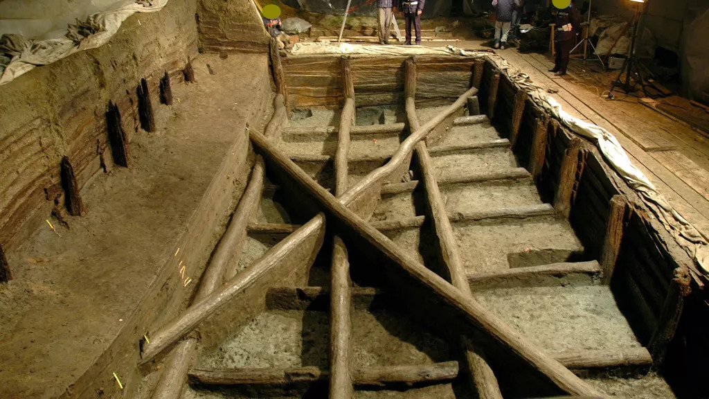
Italian archaeologists discovered the structure in 2004 near the town of Noceto, just west of Parma in Italy’s northern Po Valley region. They called it “Vasca Votiva” — Italian for “votive” or “sacred” tank. The archaeologists noted that the pit was roughly 40 feet (12 meters) long, 23 feet (7 m) wide and more than 10 feet (3 m) deep. It had been excavated on a small hilltop and then lined with wooden poles, planks and beams; most of them were oak, but some were elm or walnut.
Layers of sediment showed that the structure had once contained water, although no channels to distribute water led away from it, and it seemed much too elaborate to have been just a reservoir for irrigation, Manning said. Previous research of ceremonial pots and wooden figurines found inside had revealed that the structure was built in the Bronze Age, probably between 1600 B.C. and 1300 B.C. But its exact age couldn’t be verified, and its purpose had been a mystery. The new study resolves some of that uncertainty.
The mysterious Bronze Age structure — a pit excavated from a hilltop and extensively lined with timbers — was unearthed by Italian archaeologists in 2004 near the town of Noceto.
Ancient timbers
Manning is a specialist in dendrochronology — the science of dating ancient wood — and he and his team joined the project with the hope that determining the age of the timbers used to line the Vasca Votiva could accurately reveal when it was built.
It’s a difficult task; wood quickly rots when it is exposed to oxygen, and the record of dates for the growth of trees in ancient times often depends on rare finds of logs in the layers of sediment beneath ancient rivers and bogs, Manning said.
The team studied the growth rings from the timbers and measured each ring’s levels of radioactive carbon-14, which is a naturally occurring fraction of the carbon that the trees absorbed while they were alive. The trees stopped absorbing carbon when they were cut down, and so the levels of carbon-14 that remain can be used to date when that happened.
Then, the team calculated when the timbers were harvested using “wiggle matching,” in which they compared the patterns of carbon-14 absorption — the “wiggles” — with the distinctive patterns from trees that grew elsewhere in northern Europe at different times.
That enabled them to determine that the true date for the Vasca Votiva structure was in the middle of the 15th century B.C., which corresponded to a time of tremendous cultural change in northern Italy.
The dominant society in the region at that time, the Bronze Age Terramare culture, was transitioning from a simpler period of individual small farms to a period of greater social complexity, with the development of larger settlements that became cultural centres and increased use of ploughing and irrigation for farmland, the researchers wrote.
The structure contained ceremonial pottery vessels and wooden figurines that had been carefully placed within it; they suggested it dated from the Bronze Age, between 1,400 and 1,600 years ago. (Image credit: Cremaschi et al, PLOS One)
Reflecting waters
The new dates reinforce the idea that the mysterious structure at Noceto was built for new ritual and religious purposes established in the area, Manning said. There was no sign that the tank had ever been used as a simple reservoir for irrigation, and it was much too elaborately built; also, the ceremonial pots and figurines found inside it showed it was used for ritual offerings, he said.
As well, a great deal of labour would have been needed to complete the elaborate Vasca Votiva, and the excavations have shown that it was the second such structure at the same hilltop site. The first was even larger, and started about 10 years before the later structure; but discarded tools and wood shavings suggest that it collapsed as it was being built and so the latest tank was built over it, he said.
A few similar ceremonial water features have been found elsewhere in the ancient world, such as the earlier “lustral basins” found at Minoan sites on Crete that date back to at least the 15th century B.C., although those were smaller and typically made of clay and stone.
But nothing like this infinity pool has been found in northern Europe. “To our knowledge, it’s unique in the area,” Manning said.
He likened the Vasca Votiva to the Neolithic Stonehenge monument in southern England. Although Stonehenge is on a much larger scale, “you have these avenues leading to a particular ceremonial place; you’re sort of leaving one world that you’re part of and creating an impression that you’ve moved and joined another one,” he said.
“It was like an infinity pool, in a sense, because it was up at the top of a hill; if you were standing near it, looking into it, you would see through the water and see some of the pots and other objects that have been deposited carefully in it,” Manning added. “But you would also be very much looking at the sky and the clouds above you; it’s hard not to think that this might have to do with rainfall and things like that.”
The introduction of whatever supernatural water rituals took place at the Vasca Votiva in ancient times seems to have been an attempt to gain favour with the deities responsible for water and rainfall – elements that would have been vital to early farming communities, he said.
“If it was just for irrigation or something, then fine, but it doesn’t seem to work for that,” Manning said. “It’s more about some group activity that they think is going to be beneficial, or that the gods are going to be pleased that they have done this.”
These ancient weights helped create Europe’s first free-market more than 3000 years ago
Knowing the weight of a commodity provides an objective way to value goods in the marketplace. But did a self-regulating market even exist in the Bronze Age? And what can weight systems tell us about this?
Diffusion of weighing technology in Western Eurasia (circa 3000-1000 BC)
A team of researchers from the University of Göttingen researched this by investigating the dissemination of weight systems throughout Western Eurasia.
Their new simulation indicates that the interaction of merchants, even without substantial intervention from governments or institutions, is likely to explain the spread of Bronze Age technology to weigh goods. The results were published in Proceedings of the National Academy of Sciences (PNAS).
To determine how different units of weight emerged in different regions, researchers compared all the weight systems in use between Western Europe and the Indus Valley from 3,000-1,000 BC.
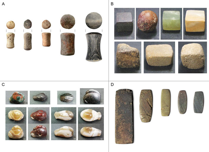
Examples of Western Eurasian balance weights of the Bronze Age. A: Spool-shaped weights from Tiryns, Greece (L Rahmstorf). B: Cubic weights from Dholavira, India (E Ascalone). C: Duck-shaped weights from Susa, Iran (E Ascalone). D: flat block weights from Lipari, Italy (N Ialongo).
Analysis of 2,274 balance weights from 127 sites revealed that with the exception of those from the Indus Valley, new and very similar units of weight appeared in a gradual spread west of Mesopotamia.
To find out if the gradual formation of these systems could be due to propagation of error from a single weight system, the researchers modelled the creation of 100 new units.
Taking into account factors such as measurement error, the simulation supported a single origin between Mesopotamia and Europe. It also showed that the Indus Valley probably developed an independent weight system.
The research demonstrated that if information flow in the Eurasia trade was free enough to support a common weight system, it was likely to be sufficient to react to local price fluctuations.
The weight systems that emerged between Mesopotamia and Europe were very similar. This meant that a single merchant could travel, for instance, from Mesopotamia to the Aegean and from there to Central Europe and never need to change their own set of weights.
The type of weighing scales a Bronze Age merchant would have carried with her when moving from one market to another to trade: suspended replica bone balance scale with flax strings and leather pouches, holding two replica weights in equilibrium
The merchant could trade with foreign partners while simply relying on approximating the weights. There was no international authority that could have regulated the accuracy of weight systems over such a wide territory and long time span. In Europe, beyond the Aegean, centralised authorities did not even exist at this time.
The researchers conclude that the emergence of accurate weight systems must have been the outcome of a global network regulating itself from the bottom-up.
“With the results of our statistical analysis and experimental tests, it is now possible to prove the long-held hypothesis that free entrepreneurship was already a primary driver of the world economy even as early as the Bronze Age,” explains Professor Lorenz Rahmstorf from the Institute for Prehistory and Early History, University of Göttingen.
Merchants could interact freely, establish profitable partnerships, and take advantage of the opportunities offered by long-distance trade.
“The idea of a self-regulating market existing some 4,000 years ago puts a new perspective on the global economy of the modern era,” says Dr Nicola Ialongo, University of Göttingen. He adds, “Try to imagine all the international institutions that currently regulate our modern world economy: is global trade possible thanks to these institutions, or in spite of them?”
A Greek Farmer Stumbled on a 3,400-Year-Old Tomb in His Olive Grove While Parking His Car
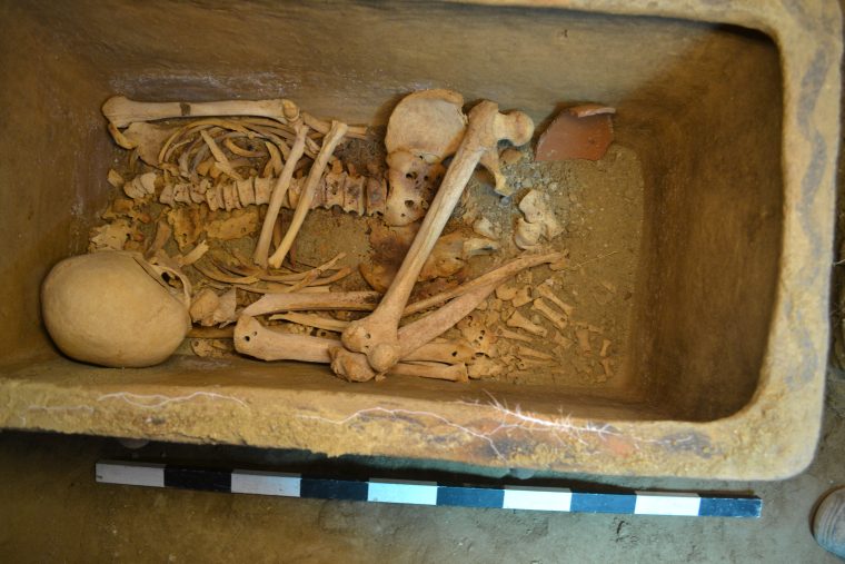
The Crete local was trying to park his vehicle when he accidentally unearthed the ancient Minoan grave. Sometime between 1400 and 1200 B.C., two Minoan men were laid to rest in an underground enclosure carved out of the soft limestone native to southeast Crete.
Both were entombed within larnakes—intricately embossed clay coffins popular in Bronze Age Minoan society—and surrounded by colorful funerary vases that hinted at their owners’ high status.
Eventually, the burial site was sealed with stone masonry and forgotten, leaving the deceased undisturbed for roughly 3,400 years.
Earlier this summer, a local farmer accidentally brought the pair’s millenia-long rest to an abrupt end, George Dvorsky reports for Gizmodo. The farmer was attempting to park his vehicle beneath a shaded olive grove on his property when the ground gave way, forcing him to find a new parking spot.
As he started to drive off, the unidentified local noticed a four-foot-wide hole that had emerged in the patch of land he’d just vacated. Perched on the edge of the gaping space, the man realized he’d unintentionally unearthed “a wonderful thing.”
An ancient Minoan tomb was discovered in this hole in Crete. Courtesy of the Greek Ministry of Culture.
An ancient Minoan tomb was discovered in this hole in Crete.
According to a statement, archaeologists from the local heritage ministry, Lassithi Ephorate of Antiquities, launched excavations below the farmer’s olive grove at Rousses, a small village just northeast of Kentri, Ierapetra, in southeast Crete.
They identified the Minoan tomb, nearly perfectly preserved despite its advanced age, in a pit measuring roughly four feet across and eight feet deep. Space’s interior was divided into three carved niches accessible by a vertical trench.
The eight-foot deep pit contained two ancient coffins and an array of funerary vases
In the northernmost niche, archaeologists found a coffin and an array of vessels scattered across the ground. The southernmost niche yielded a second sealed coffin, as well as 14 ritual Greek jars called amphorae and a bowl.
Two Minoan men were buried in the Crete tomb roughly 3,400 years ago
Forbes’ Kristina Kilgrove writes that the high quality of the pottery left in the tomb indicates the individuals buried were relatively affluent. She notes, however, that other burial sites dating to the same Late Minoan period feature more elaborate beehive-style tombs.
“These [men] could be wealthy,” Kilgrove states, “but not the wealthiest.”
Unlike many ancient tombs, the Kentri grave was never discovered by thieves, Argyris Pantazis, deputy mayor of Local Communities, Agrarian and Tourism of Ierapetra, tells local news outlet Cretapost.
In fact, the site likely would have remained sealed in perpetuity if not for the chance intervention of a broken irrigation pipe, which watered down the soil surrounding the farmer’s olive grove and led to his unexpected parking debacle.
“We are particularly pleased with this great archaeological discovery as it is expected to further enhance our culture and history,” Pantazis added in his interview with Cretapost. “Indeed, this is also a response to all those who doubt that there were Minoans in Ierapetra.”
According to Archaeology News Network, most Minoan settlements found on Crete are located in the lowlands and plains rather than the mountainous regions of Ierapetra. Still, a 2012 excavation in Anatoli, Ierapetra, revealed a Minoan mansion dating to between 1600 and 1400 B.C., roughly the same time period as the Kentri tomb.
This latest find offers further proof of the ancient civilization’s presence—as Mark Cartwright notes for Ancient History Encyclopedia, the Minoans are most renowned for their labyrinthine palace complexes, which likely inspired the classic Greek myth of Theseus and the Minotaur.
According to legend, Queen Pasiphae of Crete gave birth to the Minotaur, a fierce half-man, half-bull hybrid, after falling for a bull sent to Earth by the Greek god Zeus.
The Minotaur, doomed to an eternity spent wandering the halls of an underground labyrinth and killing anyone it encountered, was eventually defeated by the demigod Theseus, who relied on an enchanted ball of thread provided by the king’s daughter, Ariadne, to escape the maze.
Much of the Minoans’ history remains unclear, but Forbes’ Kilgrove reports that natural disasters, including the eruption of the Thera volcano, an earthquake and a tsunami, contributed to the group’s downfall, enabling enemies such as the Mycenaeans to easily invade.
Analysis of the excavated Kentri tomb may offer further insights into the Minoan-Mycenaean rivalry, as well as the Cretan civilization’s eventual demise.
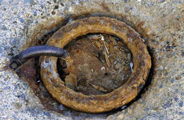
Have researchers found 30-million-year-old “Giant Rings” in the Bosnian mountains?
Through the last few decades, scientists have discovered a number of mysterious ancient giant rings at numerous locations in the Bosnian mountains.
According to the local population, it is believed that these “artefacts” date back to the era of the Pannonian Sea, and legends suggest these were used by giant beings who inhabited the area in the distant past ― millions of years ago!
Although the Pannonian Sea disappeared around 600 000 years ago, it was not a short-lived sea. In fact, it lasted for about 10 million years. Although, the sources on this duration differ ― some claiming that the sea lasted for over 30 million years. The Pannonian sea existed during the Miocene and Pliocene eras.
Recent discoveries point to a time when giants roamed the Earth. The mysterious giant rings that were found on top of mountains suggest that these were used by giant beings who inhabited the region millions of years ago.
Local residents have mixed feelings about these mysterious rings. Some have suggested a particularly simple explanation. According to some local residents, these “giant” rings belong to the Austro-Hungarian empire put in place to help the transport of timber across the harsh mountains of the region.
Large metal hoops that were used to moor ships during the Pannonian Sea are unknown to most today.
Those who support this theory point out that these giant rings were somehow placed inside the mountains at a time when the Pannonian Sea still existed. These giant rings were used to bind ships, and the region was used as a seaport.
There are legends in the region that speak of giants and their huge ships. There are assumptions that these giant rings were made by giants, ancient ship owners and sailors who inhabited the region in the distant past.
But is it possible that these rings are millions of years old? If so, how? What material are they made of? As there has been no “official” research done the possibilities are endless.
Local residents have stated that there are numerous other findings in the area which cannot be explained, and all of these findings are being deliberately hidden from the people.
These giant rings and giant rocks that seem to be finely carved are found at the hills around Vogosca between Breza and Vares, near Dubrovnik and in several places in eastern Bosnia. There are also four of these at Bjelasnica and Vlasic, Vranica, Prenj, Velez, then Majevica, Bukovica near Travnik, above Stolac. The locals stress how important it is to examine these findings.
Bosnia’s forest regions where the ancient rings and rocks are found.
The locals have talked about these mysterious rings for years, and there are mixed feelings when it comes to findings like these. While some suggest that it is literally impossible for these giant rings to be that old, others believe that this points to the fact that giants roamed the Earth in the distant past, and evidence of this can be found all over the world.
Those who firmly believe it is impossible for these giant rings to be that old point to the fact that the Pannonian Sea was located in the area of the Pannonian Plain about 30 million years ago. This sea disappeared around 600,000 years ago.
There simply would not be a good reason to create giant rings to bind ships to if these ships wouldn’t be able to reach these “ports”. Yet many people have seen the giant rings, but some suggest these were not used to tie boats to the coast.
At the time of the Pannonian Sea, there were no people, thus, who could have constructed the boats? So if there was no one to build a boat, who would have created the rings? The first hominins who built tools date back to around 200,000 years ago, the time gap between them and the Pannonian Sea is 400,000 years.
Kozara, where the giant rings were found, was an island in the Paratethyan ocean 50,000 years ago. As the Pannonian Sea withdrew, the coastlines appeared. This is why, Dragan Romčević, director of the National Park “Kozara” states that these giant rings can not be from this period.
Others suggest that these “giant rings” were put in place in the recent past and were used to secure “weather balloons” to the ground.
Large metal hoops that were used to moor ships during the Pannonian Sea are unknown to most today.
Dejan pelvis, a professor of history at the Prijedor Gymnasium believes that these rings of Kozara are one of those incredible mysteries associated to the past. All these mysteries share one and same fact ― that no one can accurately explain their origin and purpose. These findings are shrouded in mystery.
This is a topic on which scientists cannot offer explanations, simply because it lacks logical facts, and since science cannot explain these mysterious artefacts, people have no choice but to interpret the phenomena themselves, and then, everything becomes possible.
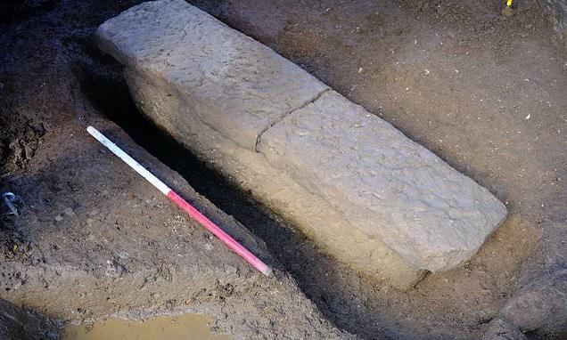
Roman sarcophagus discovered in Bath contained two skeletons, with one laid at the other’s feet
In the British city of Bath, two separate skeletons were discovered inside a Roman-era tomb. A well-preserved body was discovered face-down with the partial remains of another person positioned at its feet.
Beads and pottery that may have contained food were also discovered at the site, suggesting they were some kind of offering.
The limestone casket, along with stone walls and evidence of a cremation burial, were uncovered at Bathwick Roman Cemetery in southwest Bath’s Sydney Gardens, the last remaining Georgian pleasure gardens in the UK.
The casket, found in a grave about six feet long, 23 inches wide and 19 inches deep, was north-facing, suggesting it was a pagan burial.
The cremation burial is the only recorded one of its kind in the Bathwick Cemetery, according to the BBC.
A nearly 2,000-year-old Roman sarcophagus containing two bodies was discovered in Bath, England. Its northern-facing orientation and the presence of offerings suggest it was a pagan burial, archaeologists say
‘Having a human skeleton directly associated with a coffin is a rarity and to have this one associated with what was probably votive offering and a nearby human cremation, allows a very rare glimpse into funerary practices in the region almost two millennia ago,’ archaeologist Kelly Madigan, who worked on the excavation, said in a statement.
Calling the discovery ‘a real career highlight,’ Madigan said that testing of the bones could offer new information, ‘where we can delve deeper into just who the people we found in the coffin were, where they were from and their health and welfare.’
The limestone casket, along with stone walls and evidence of a cremation burial, were uncovered at Bathwick Roman Cemetery in southwest Bath
Historic England advisor Sylvia Warman called the discovery ‘a first for Bathwick and a really significant find for Roman Bath and the World Heritage Site.’
The baths remain a major tourist attraction and receive over a million visitors a year.
While habitation goes back to the Neolithic era, the city proper was founded in 43AD, when the Romans turned a patch of marshland into the ancient world’s equivalent of a luxury spa, taking advantage of the millions of gallons of warm water bubbling up from natural hot springs.
They named it Aquae Sulis, after the Celtic goddess Sulis, associated with the Roman deity Minerva.
The Romans constructed elaborate baths in the city in the first century AD, taking advantage of natural hot springs that provided warm water. More than a million tourists visit Bath each year
A temple dedicated to Minerva was erected in 70 AD, and the bathhouse was expanded and improved over the next 300 years.
By the 5th century, with the fall of the Roman empire, the baths fell into disrepair and were eventually abandoned.
In 2007, archaeologists found a massive hoard of 30,000 Roman coins less than 500 feet from the baths, the BBC reported. The collection, one of the largest ever found in the country, dates to about 270 AD.
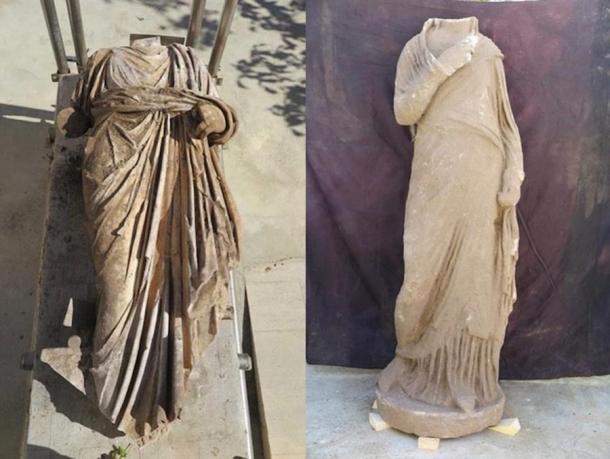
1,800-year-old headless Greek statue found at Turkey’s Metropolis site
Archaeologists in western Turkey have unearthed a 1,800-year-old marble statue from the ancient ruins of Metropolis, known as ‘City of the Mother Goddess’ during the Roman period.
Earlier this month, the Turkish Culture and Tourism Ministry’s Department announced the discovery of the Roman-era statue, a robed female figure with her head and both arms missing.
The limbs were probably attached separately, according to Art News, though more work needs to be done to uncover the identity of the figure, researchers say.
The current excavation is a collaboration between the ministry and Celal Bayar University in Manisa, Turkey.
Metropolis (Greek for ‘mother state’) was a name bestowed on various cities, though this one is in Western Turkey’s Torbali municipality, about 25 miles from modern-day Izmir, the country’s third-largest city.
The headless Greek statue.
Humans have occupied the land for at least 8,000 years, since the Neolithic period.
Artefacts indicate it was inhabited by Hittites during the Bronze Age (when it was known as Puranda) and was also active during the Hellenistic, Roman, Byzantine and Ottoman periods.
It was founded as Metropolis by the Greeks in roughly 300 BC and, despite its matriarchal name, was home to one of only two known temples devoted to Ares, the Greek god of War.
The sculpture dates to Metropolis’ Roman era—when the empire controlled Anatolia, the portion of Turkey located on the Asian continent.
Roman scientist-philosopher Ptolemy described the town as an important trading post in Lydia, about halfway along the ancient trade routes between Smyrna and Ephesus.
Though the figure’s head and arms are missing archaeologists say she is otherwise quite well-preserved
Fieldwork began in the region in the 1970s, with excavations at Metropolis starting in the mid-1980s.
Since then, archaeologists have uncovered more than 11,000 artefacts, according to Art News, including coins, ceramics, glass, ivory and metal objects.
The city ‘has a deep-rooted history dating back to prehistoric times,’ Celal Bayar University archaeologist Serdar Aybek told the Turkish-language Demirören News Agency in January, according to an English-language report in Arkeonews.
‘It has the fertility brought by the Küçük Menderes River. It is a region that has always been settled.’
Notable finds include a Hellenistic marble seat of honour uncovered in the outdoor theatre, elaborate Roman baths featuring sculptures of Zeus and Thyke, goddess of good fortune, as well as other Roman-era buildings including a sports complex, government building, various shops, galleries and public toilets.
More recently, four massive interlocking cisterns big enough to hold 600 tons of water were uncovered in the city’s acropolis last year. It’s believed they were used during the Late Roman period and may have been helpful when the city was under siege by invaders.
The Greek theatre at Metropolis restored in 2001. Photo taken 2007.
In the 12th and 13th centuries, when the cisterns were no longer used to provide water, they became a garbage dump, with animal bones, broken ceramics and other detritus of daily life found on the site, according to the Daily Sabah.
The Turkish government opened the ‘City of the Mother Goddess’ to tourists in 2014.
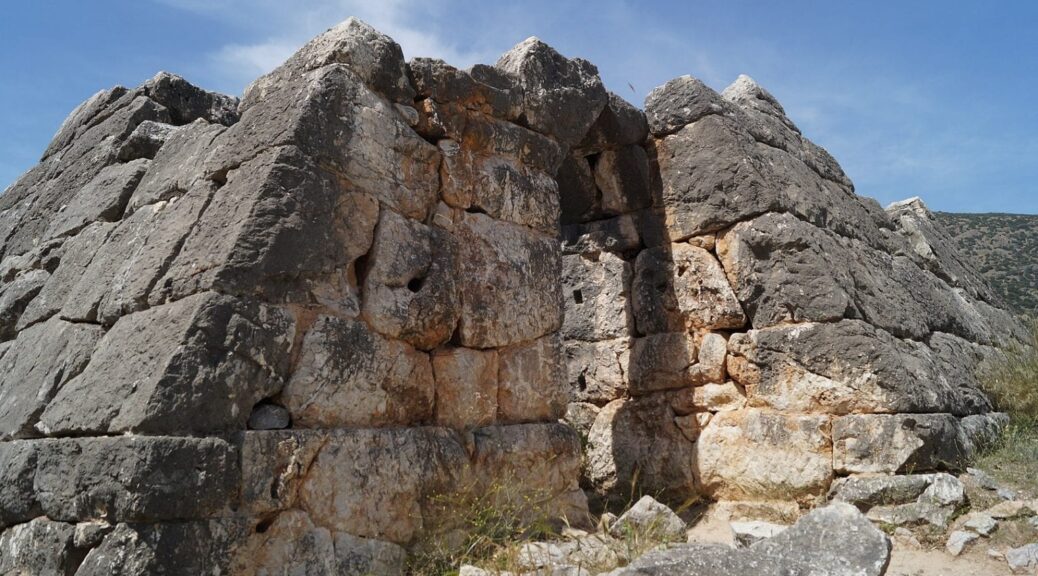
Ancient Greek Pyramids: A Unique Phenomenon and an Archaeological Mystery
The so-called Greek Pyramids, also called the Pyramids of Argolis, are several frusta or truncated pyramidal shaped structures and “blockhouses”, located on the eastern part of the Peloponnese peninsula in present-day Greece.
Although the structures are distinct in form and shape from typical Ancient Greek architecture, mention of the monuments in antiquity is scarce, with only the geographer Pausanias (AD 110-180) observing a single pyramidal monument (although associating Pausanias’s text with the Pyramids of Argolis is contested) in his Corinthiaka that states:
“Traveling from Argus to the region of Epidaurus, there is a building to the right that resembles very much a pyramid and bears relief carved shields of the shape of the Argolic shields.
In this place, Proetus had battled with Acrisius for the throne and they say that the battle ended without a winner; for this reason, they were later reconciled, as none could achieve a decisive victory.
It is said that this was the first time that men and armies equipped with shields clashed; for those that fell in this battle from both armies, since they were compatriots and even relatives, a common tomb was built in that place.”
Groups of possible pyramidal structures have been identified at Ligourio (Argolida), Kambia (Argolida), Viglafia (Lakonia), and Elliniko (Argolida), with the pyramid of Hellinikon at Elliniko being the best preserved and studied.
Dating of the monuments has been troublesome due to the lack of archaeological material, with previously disputed studies of ceramics from the Protohelladic II period dated to 2800–2500 BC, early thermoluminescence dating giving a range of 2500–2000 BC, but many proponents support the proposed construction during the Late Classical Hellenistic period, centred on the later 4th century BC.
Historical theories for the structures function have tried to establish an “Egyptian connection”, suggesting guard houses for Egyptian mercenaries, or burial practices that paralleled with the Ancient Egyptians, but these theories lack all credibility and without evidence.
The more likely theory looks at the structures’ presence of internal walls, small rooms, cisterns, the provision of a water supply, and internally fastened doors within the monuments, that Young (1957) and Fracchia (1985) proposed was for an agricultural function, possibly with a secondary function of providing a refuge in turbulent times.