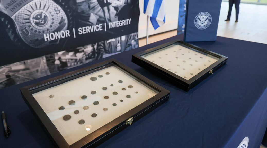
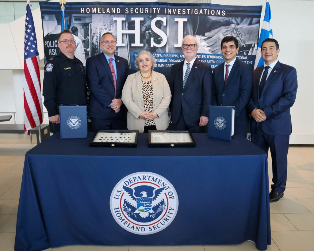
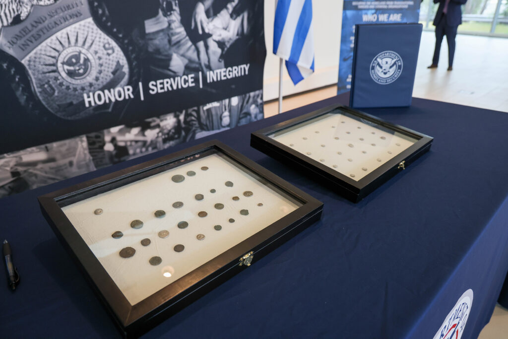
Homeland Security Investigations (HSI) Chicago, alongside distinguished representatives from Greece and the National Hellenic Museum, conducted a repatriation ceremony on June 16 to return to Greece the largest number of stolen ancient coins seized by U.S. law enforcement officials in recent HSI history.
Federal agents, National Hellenic Museum conduct the largest repatriation of ancient coins to Greece in recent HSI history
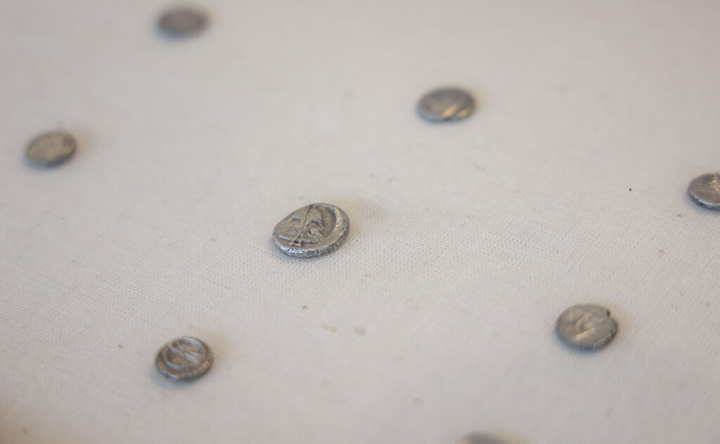
The artifacts included 51 ancient Greek coins that U.S. Customs and Border Protection (CBP) intercepted via four separate examinations of merchandise entering the United States.
“Trafficking in antiquities is a multibillion-dollar criminal enterprise, but when traffickers steal these antiquities from a country, they’re robbing from the cultural heritage of a nation – solely for their potential to generate profit,” said HSI Chicago Special Agent in Charge R. Sean Fitzgerald. “HSI possesses the unique skills and determination necessary to disrupt this concerning practice. At HSI Chicago, we have a dedicated unit with agents specially trained to track down lost and stolen pieces, ultimately contributing to approximately 20,000 artifacts that HSI has recovered and returned to over 40 countries since 2007.”
As a result of the original shippers’ and consignees’ inability or unwillingness to provide proper documentation of ownership, CBP seized the coins and turned them over to HSI.
The distinguished guests present at the repatriation included the Ambassador of Greece to the United States Alexandra Papadopoulou, Consul General Emmanuel Koubarakis, and Consul Georgia Tasiopoulou.
“This is a successful example of how when we join forces, we can make miracles,” said Papadopoulou.
“As these coins get back to Greece where they belong, I’m sure it will make an exciting, powerful display as part of our culture, as part of our shared identity, and as part of our close relationship with the United States.”
This return of these ancient coins was made possible by the investigative efforts of HSI Chicago, HSI’s Cultural Property, Art and Antiquities (CPAA) program, and law enforcement partners at CBP.
One of the primary goals of the CPAA program is to protect and preserve the world’s cultural heritage and knowledge of past civilizations.
CPAA conducts training and outreach, supports cultural property investigations, and enhances international relations by working with foreign governments and citizens to return their nation’s looted cultural heritage and stolen artwork.
“It is often extremely difficult to put a specific monetary value on an ancient historical coin,” said Fitzgerald. “That notwithstanding, as tokens of the world’s oldest democracy, Greece’s cultural property — in HSI’s view — is considered priceless.”
Since 2007, HSI investigations have led to the repatriation of over 20,000 objects to more than 40 countries and institutions. The repatriated objects have included paintings, sarcophagi, statues, coins, and illuminated manuscripts.
In the fiscal year 2022, HSI’s CPAA program repatriated cultural property to more than 15 countries, including France, India, Iraq, Italy, and Mali.
Among the repatriated items were cuneiform tablets, religious artifacts, and architectural drawings stolen from Jewish communities during the Holocaust.
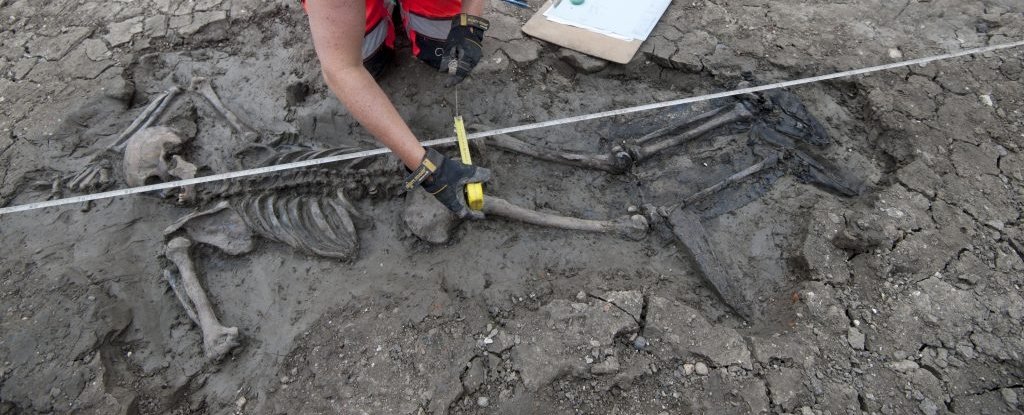
Vast cemetery of Bronze Age burial mounds unearthed near Stonehenge
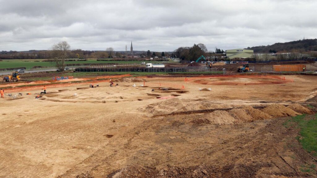
Archaeologists from Cotswold Archaeology have found a vast Bronze Age burial ground near Stonehenge in the southwest of England.
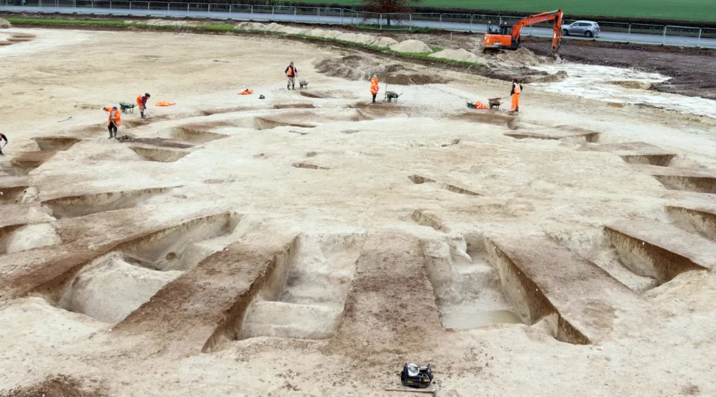
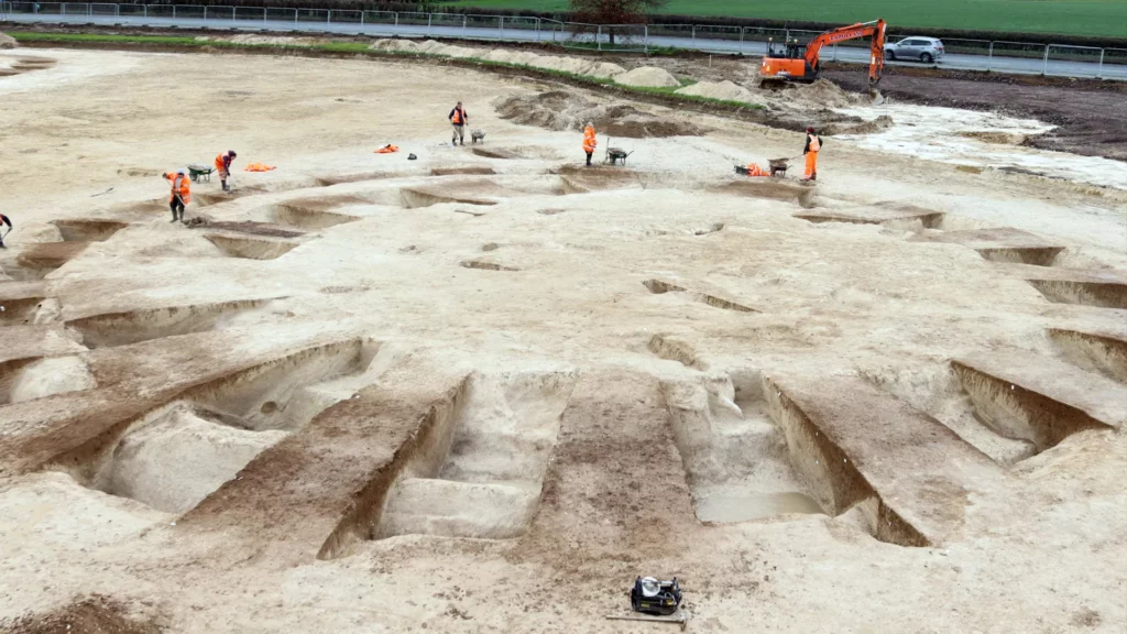
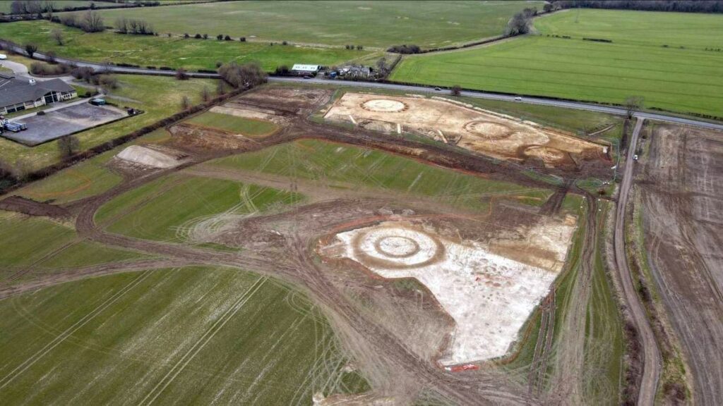
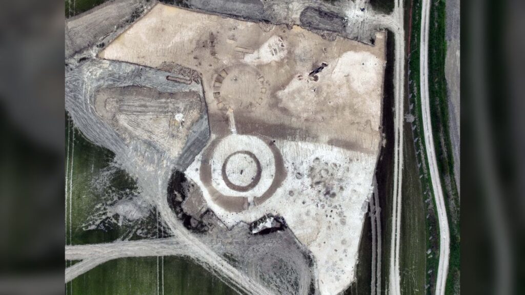
Archaeologists have discovered a vast cemetery of Bronze Age burial mounds, thought to be up to 4,400 years old, ahead of a building development less than 10 miles (16 kilometers) from Stonehenge.
The cemetery includes more than 20 circular mounds, known as barrows, built between 2400 B.C. and 1500 B.C. on a chalk hillside near Harnham on the outskirts of Salisbury in southwest England.
Other than the site’s proximity to Stonehenge, there’s no evidence that the cemetery was connected with the famous monument. But the barrows were built around the same time as some of the central stages of Stonehenge, according to a statement from Cotswold Archaeology, a private firm conducting the excavations.
The ancient burial ground has been investigated by archaeologists ahead of a building development at the site, on the outskirts of the city of Salisbury.
Many archaeologists now think Stonehenge, too, was mainly a burial ground, although it also may have functioned as a communal gathering place or even a calendar.
The newfound barrows range in size, with the smallest measuring about 33 feet (10 meters) across and the largest spanning 165 feet (50 m). But most of the barrows are between 65 and 100 feet (20 and 30 m) across.
The burial ground consists of more than 20 roughly-circular burial mounds or barrows, some more than 100 feet across.
Ancient barrows
The barrows at the cemetery are grouped in “pairs or small clusters of six or so,” Alistair Barclay, an archaeologist at Cotswold Archaeology and the site’s post-excavation manager, told Live Science in an email.
After arriving at the site in 2022, the archaeologists have now fully excavated five barrows in two areas. Four of the barrows had previously been identified, but the fifth was unknown, possibly because it had been covered by loose soil washed down from an uphill area.
One of the barrows was originally enclosed by an oval-shaped ditch that was replaced in prehistory with a nearly circular ditch. That suggests this barrow might have been built before the others, during the Neolithic period, which ended around 2400 B.C.; a mass grave near its center held the skeletal remains of adults and children, the statement said.
Most of the barrows were built in the Bronze Age between 4,400 and 3,500 years ago, but archaeologists think the oldest barrow maybe even earlier.
The oval ditch also cut through pits of red deer (Cervus elaphus) antlers, which were highly prized in the Neolithic for making tools, ritual artifacts, and small items like pins and combs.
The antlers will now be checked for signs of deliberate breakage or wear that could indicate they were once used to make tools, the statement said.
A ditch around the oldest barrow cuts through a cache of red deer antlers, which were used to make tools and small items in Britain’s Neolithic period, between 6,500 and 4,400 years ago.
Prehistoric burials
The archaeologists have excavated the remains of nine other burials and three artifacts from graves among the barrows. In some cases, the grave goods were pottery “beakers” — distinctive round drinking vessels — indicating that the people buried there were from the Bronze Age “Bell Beaker culture,” which was widespread in Britain after about 2450 B.C.
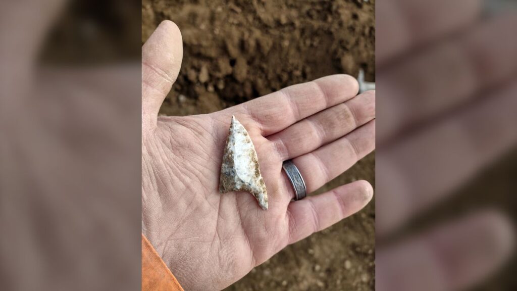
Archaeologists now think the site was used for different purposes during the Neolithic period, the Bronze Age, the Iron Age, and the Anglo-Saxon Age. This “British Oblique” arrowhead was made from flint during the Neolithic.
The Cotswold Archaeology team has also found evidence of later occupations at the site, including what may be traces of an Iron Age cultivation area. It consists of more than 240 pits and postholes.
Some of the pits may have been used to store grain, but most were used for discarding rubbish — a boon to archaeologists studying how people lived and farmed the land at that time.
The team also found evidence of a Saxon building at the site, along with other artifacts from the Anglo-Saxon age (fifth to 11th centuries A.D.)
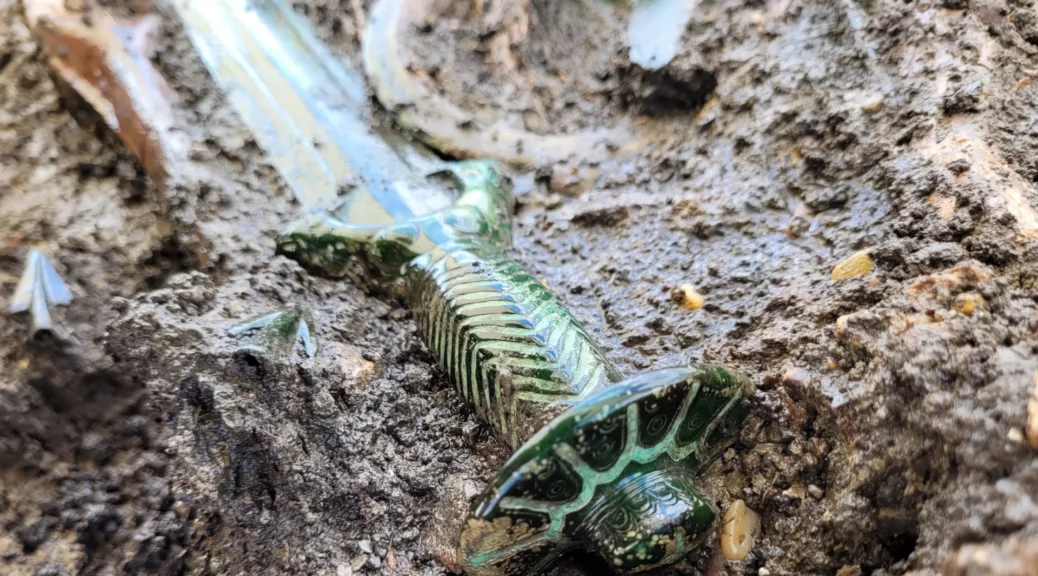
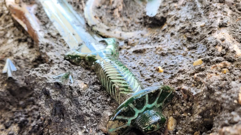
Well-Preserved Bronze Age Sword Discovered in Germany
The 3,000-year-old weapon is known as an octagonal sword.
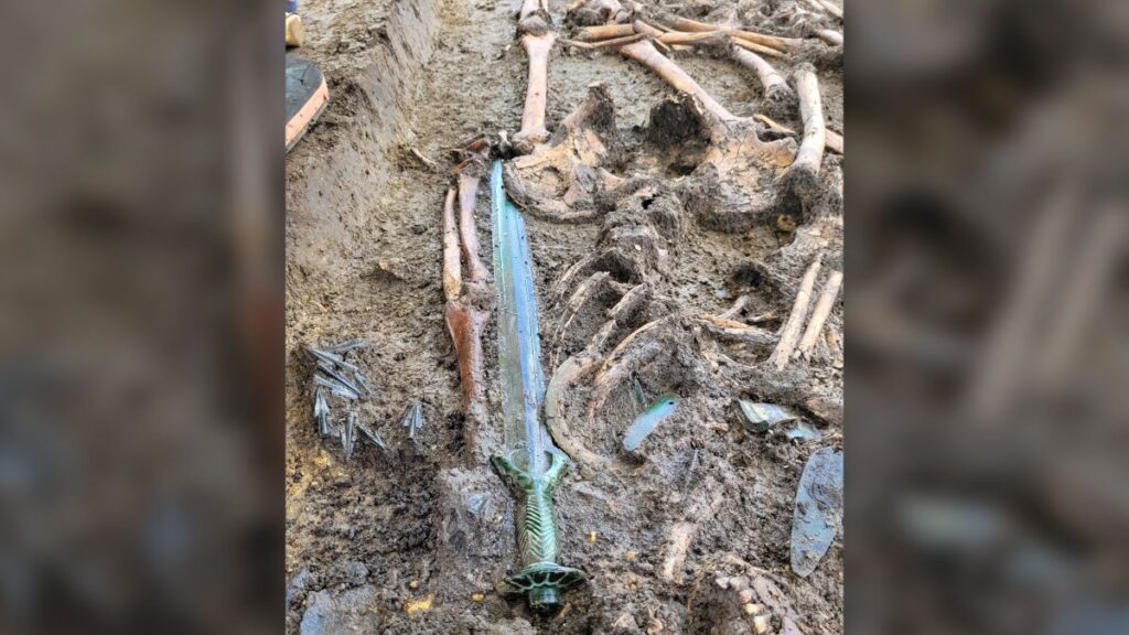
Archaeologists in Germany have unearthed a sword from a Bronze Age burial, and the weapon is in such good condition that it still gleams.
The 3,000-year-old sword, discovered in the town of Nördlingen in Bavaria, was found in the burial of a man, woman, and child. It appears that the trio was buried in quick succession, but it’s unclear if they are related to one another, according to a statement the Bavarian State Office for Monument Protection released on Wednesday (June 14).
The bronze hilt has turned green since it was crafted in the middle Bronze Age.
The sword is so well preserved, “it almost still shines,” according to the translated statement.
The weapon has an ornate octagonal hilt crafted from bronze that now has a greenish tinge, as bronze contains copper, a metal that oxidizes when exposed to air and water.
The newfound sword was discovered in a burial that had the remains of a man, woman, and child.
Archaeologists dated the sword to the end of the 14th century B.C. Sword discoveries from this time and region are rare, as many middle Bronze Age graves were looted over the millennia, the team said.
Only skilled smiths could make octagonal swords. The handle, which has two rivets, was cast over the blade in a technique known as overlay casting.
However, the blade doesn’t have any visible cut marks or signs of wear, suggesting that it had a ceremonial or symbolic purpose, according to the statement.
Even so, the sword could have easily served as an active weapon, as the center of gravity on the blade’s front end suggests that it could have effectively slashed opponents.
Researchers know of two manufacturing areas for octagonal swords in Germany. One region, a local one, was in southern Germany, while the other hailed from northern Germany and Denmark, according to the statement. It’s unknown where the newfound sword was cast.
“The sword and the burial still have to be examined so that our archaeologists can classify this find more precisely,” Mathias Pfeil, head of the Bavarian State Office for Monument Protection who is involved with the sword’s conservation, said in the statement. “But it can already be said: the condition is exceptional! A find like this is very rare!”
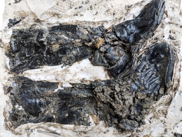
In the mud of London’s Thames River, a strange skeleton that lay hidden for 500 years has finally seen the light of day. Face down, one arm upflung, the only remnants of his clothing were a pair of half-rotted, thigh-high black leather boots.
It’s those boots that have archaeologists abuzz – an incredibly rare find.
“It’s extremely rare to find any boots from the late 15th century, let alone a skeleton still wearing them,” explained Beth Richardson of the Museum of London Archaeology (MOLA) to National Geographic.
Because the British Isles have such a rich and ancient history, England has legislation to ensure that archaeological assessments and appropriate preservation measures are carried out for all major development.
So the bones were found as part of excavations for the Thames Tideway Tunnel, a project to divert sewage away from the Thames, in a bid to reduce pollution.
It’s not unusual to find artifacts and remains in and around the Thames. The area around the river has been inhabited for a long time, and anyone who’s lived near a body of water knows how easy it is to lose items in the murky depths. But the clothing of any kind is extremely rare.
“Historic clothing mostly survives accidentally, and the further back in time, the less there is. The majority of survivals are therefore elite or special garments that are exceptional compared with what the majority of people would have worn,” dress historian and archaeological textile specialist Hilary Davidson of La Trobe University in Melbourne, who was not associated with the discovery, told ScienceAlert.
“Also, it’s extremely rare to find boots still on their wearer. Most medieval footwear found in London was originally discarded into rubbish heaps, which is where it survived.”
The fact that he was still wearing the boots – as well as his location, face-down pose, and preliminary assessment of his bones – have allowed archaeologists to make a few educated guesses about his death, and the life he led beforehand.
The boots were well made, stitched with flax thread, with reinforced soles, and stuffed with an unknown plant material, perhaps for a better fit.
These boots are made for lastin’.
The fact that they were so long – thigh-length with the tops unrolled – suggests that he may have worked on the river as a fisherman or sailor, wearing the boots as waders to protect his legs. Wear on his teeth is consistent with a repetitive action – such as passing a rope through them, as a fisherman or sailor might.
This lifestyle is supported by the style of the boot, which, according to Davidson, was not the high fashion of the time, but close to the everyday shoes of the working class seen in paintings in the 14th and 15th centuries.
If he was a river worker, this could help explain the remarkable state of the boots’ preservation.
“While cellulosic fabrics such as linen tend to decay in waterlogged areas, protein-based garments like wool and especially leather survive anaerobic damp conditions much better,” Davidson explained.
“The tanning process makes leather even more durable, and if his boots were for working in the water they may have had extra protection like oils, fats, pitch, or resin worked into the hide which has helped them last for 500 years – better than his skin.”
And they even offer clues as to how he died. MOLA notes that leather was a highly prized material at the time, often reused and recycled. So, had he been buried by his loved ones, it’s likely they would have removed his boots for re-use first.
This suggests that his death was a tragic one, either by accident or design, and an examination of his bones supports this theory. He was less than 35 years old. However, since his bones show no signs of trauma, we’ll probably never know whether he was pushed, fell, or jumped.
Ongoing conservation work on the boots will hopefully reveal more about material reality – what people wore, how they wore it, and their relationship with the dangerous river that has proven to be an incredible thread woven throughout history.
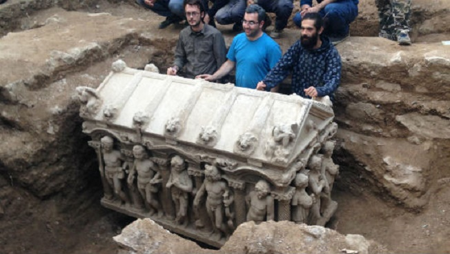
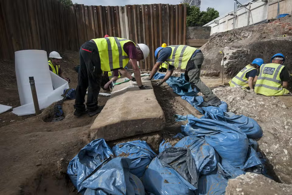
Baby’s bones and ancient sarcophagus found at Borough Market building site
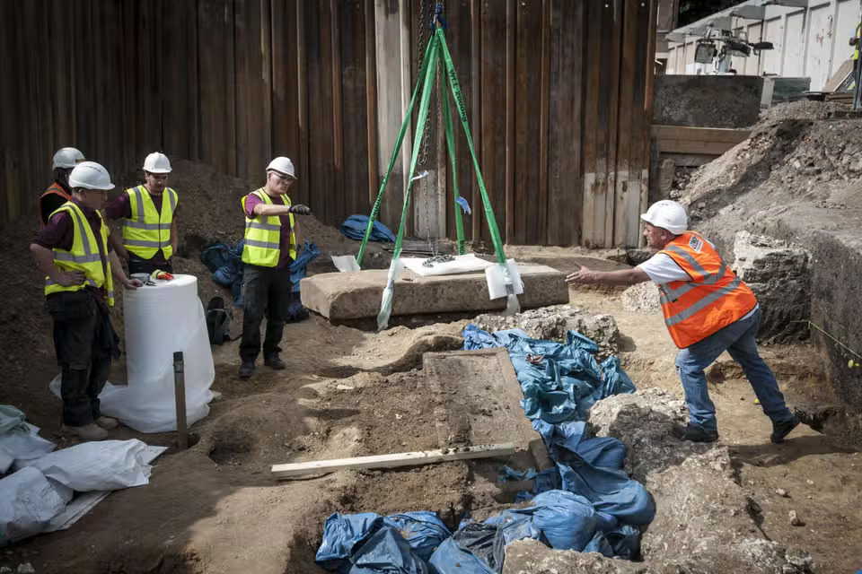
Archaeologists have lifted the lid of an ancient Roman sarcophagus unearthed at a building site near London’s Borough Market. The 1,600-year-old stone coffin, discovered at Swan Street, Southwark, is thought to contain the remains of a mother after the bones of a baby were found nearby.
An amazing series of photos shows excited archaeologists peeking inside the sarcophagus on Tuesday.
Small bones and a broken Roman bracelet were meanwhile found in the surrounding soil, hinting as to who the tomb was made for.
Diggers found a bracelet and small bones near the sarcophagus
The team is not certain whether the infant was buried with the coffin, however, as it appears to have been opened by grave robbers in an area that was used by the Romans as a burial ground.
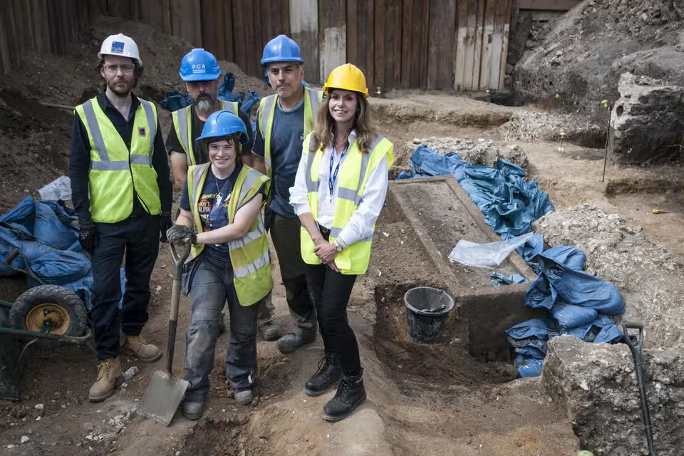
Gillian King, senior planner for archaeology at Southwark Council, said a large crack on the lid was probably the work of thieves.
“It’s been broken into two pieces, probably when robbers broke into it during the post-medieval period,” she said.
To me! Archaeologists finally take a peek inside the coffin
“We hope that they will have left the things that were of small value to them but great value to us as archaeologists.
“We always knew this site had the potential for a Roman cemetery, but we never knew there would be a sarcophagus.”
The coffin was found several meters underground at the site last month after the council told developers to pay for an archaeological dig.
Gillian King, right, senior planner for archaeology at Southwark Council, stands with other archaeologists after they lifted the lid
Its lid had been slid open, leading experts to suspect it was targeted by thieves back in the 18th century.
The council had asked developers to check the area for ancient finds before it went ahead with building new flats because of the site’s proximity to two large Roman roads.
Strict rules on Roman burials, which had to be outside of town walls, meant the location was a prime spot for historical finds.
Archaeologists discovered the coffin six months into the dig as they were due to finish their search.
They believe it was the coffin of a high-status inhabitant of Roman London, but they will not know for sure until the bones and soil inside are tested and dated.
The sarcophagus will now be taken to the Museum of London’s archive in Hackney for analysis.
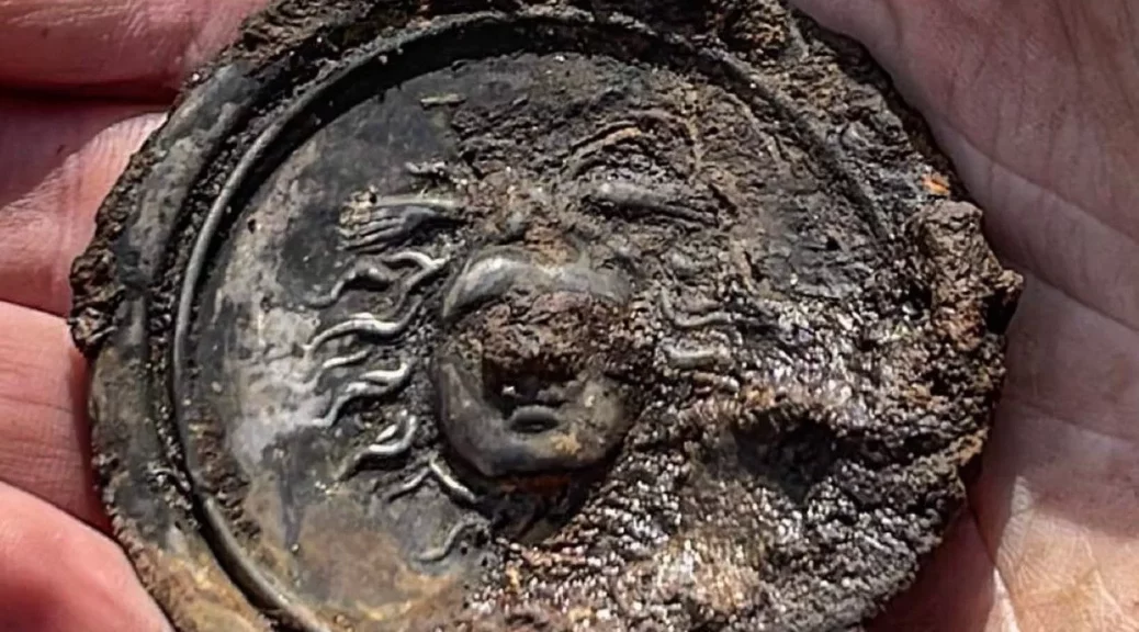
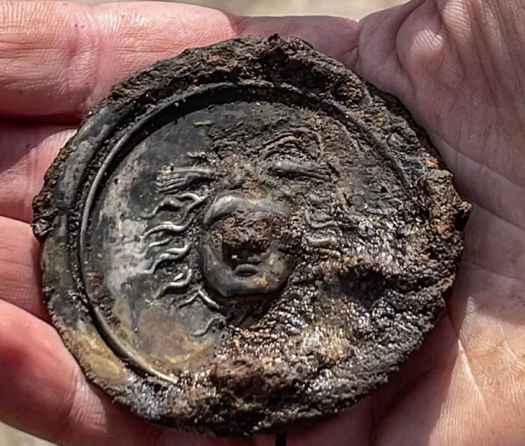
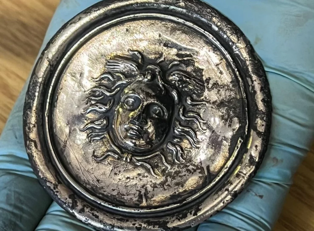
Volunteer archaeologists discovered a 1900-year-old silver military decoration in Vindolanda
Volunteer archaeologists have discovered a 1900-year-old military decoration (Phalera) that was awarded to distinguished soldiers and troops in the Roman army in Vindolanda, in northern England.
Vindolanda was a Roman auxiliary fort (castrum) one mile south of Hadrian’s Wall in northern England. Roman Vindolanda Fort is one of Europe’s most important Roman archaeological sites and situated on the Stanegate Road.
The site itself is made up of nine forts that are built on top of each other. Soldiers from all over the Roman Empire were stationed here, including Belgium, Germany, and France.
The visible stone fort dates from the third century and includes the fort walls, the headquarters building, the Commanding Officer’s house, granaries, and barracks.
The extramural settlement’s ruins can be found just outside the fort’s walls. A main street is lined with houses, shops, a tavern, and a bathhouse.
Excavations take place on the site every year and attract hundreds of volunteers from all over the world. Recent excavations on the floor of a barracks building uncovered a silver phalera disk, which Roman soldiers wore on their breastplates during parades.
The silver military decoration bearing the head of Medusa, a monster in the form of a woman with snakes for hair, the very sight of which would turn a person to stone.
Medusa, also known as Gorgo in Greek mythology, was one of the three monstrous Gorgons, who were generally described as winged human females with living venomous snakes in place of hair.
We are having a really good week!
This is a silver phalera (military decoration) depicting the head of Medusa,uncovered from a barrack floor, dating to the Hadrianic period of occupation. #Vindolandapic.twitter.com/b0Gs3MiixF
— Vindolanda Trust (@VindolandaTrust) June 8, 2023
The head of Medusa was carved in relief on the silver phalera unearthed in the Vindolanda. The head of Medusa also functions as a kind of apotropaic symbol, that is, as a protector.
Volunteer archaeologists have also found during this season’s excavations, a spearhead, a copper alloy spoon, a stamped mortarium rim, Samian pottery, a melon bead, an enameled bow brooch, a copper alloy scabbard chape (the protective fitting at the bottom of a scabbard or sheath for a dagger), and a well preserved wooden bath clog.
The discovery was shared on the Vindolanda Trust Twitter account.
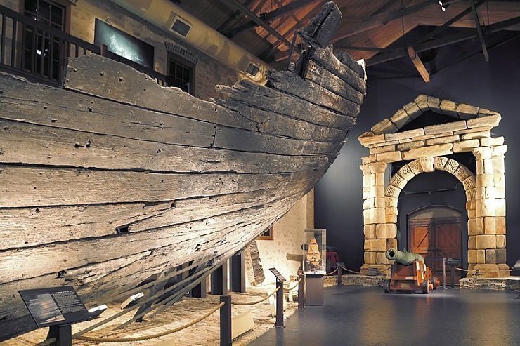
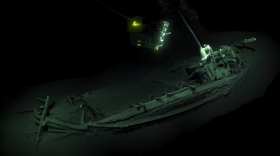
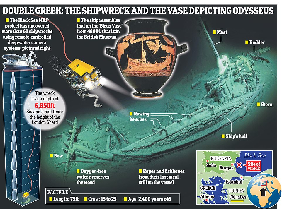
World’s Oldest Intact Shipwreck Found at the Bottom of the Black Sea
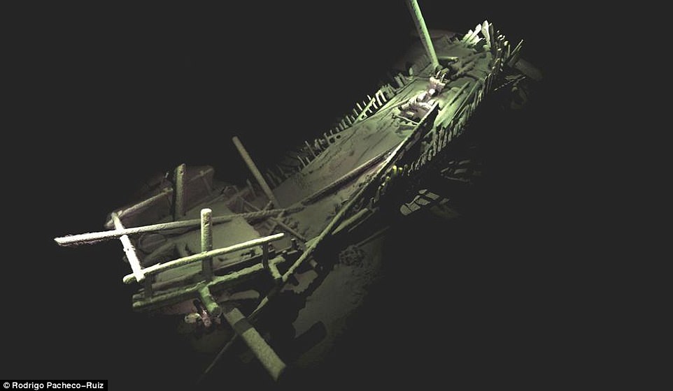
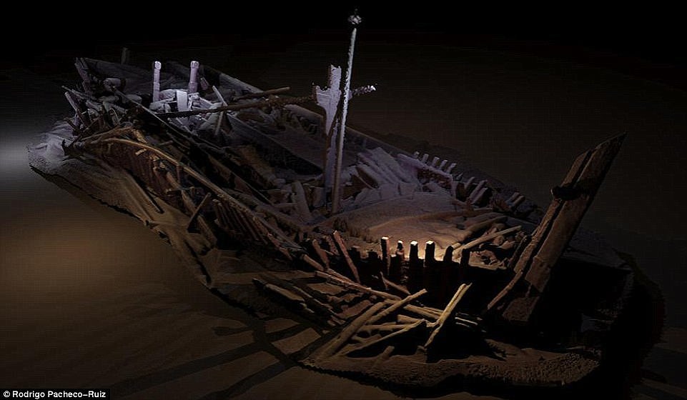
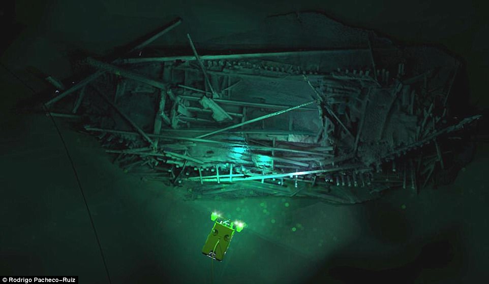
The oldest intact shipwreck ever found has been discovered at the bottom of the Black Sea. The 75ft Greek trading vessel was found lying whole with its mast, rudders and rowing benches after more than 2,400 years. It was found in a well-known ‘shipwreck graveyard’ that has already revealed over 60 other vessels. During the most recent exploration in late 2017, the team discovered what has now been confirmed as the world’s ‘oldest intact shipwreck’ – a Greek trading vessel design previously only seen on the side of ancient Greek pottery such as the ‘Siren Vase’ in the British Museum.
The ship, found 1.3 miles under the surface, could shed new light on the ancient Greek tale of Odysseus tying himself to a mast to avoid being tempted by sirens. The vase shows Odysseus, the hero from Homer’s epic poem, tied to the mast of a similar ship as he resisted the Siren’s calls.
The 75ft shipwreck was been found lying whole with its mast, rudders and rowing benches after more than 2,400 years.
The shipwreck was found nearly 7,000ft under the sea in ‘remarkable’ condition, with some suggesting it has similarities to a ship shown on an ancient vase that depicts Odysseus tying the mast of a similar ship as he resisted the Siren’s calls
Archaeologist discover the worlds oldest shipwreck in the Black Sea
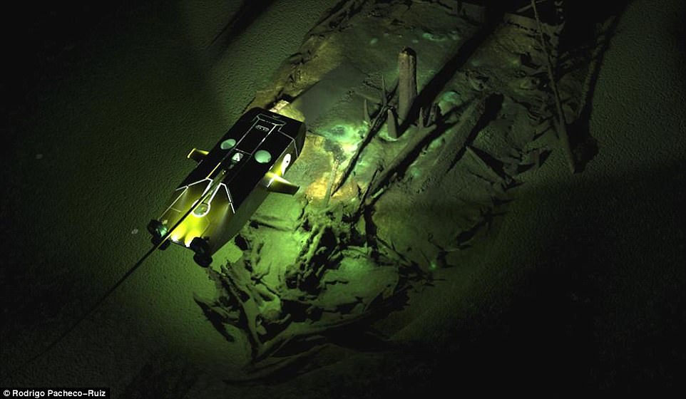
The 75ft shipwreck was been found lying whole with its mast, rudders and rowing benches after more than 2,400 years. The shipwreck was found nearly 7,000ft under the sea in ‘remarkable’ condition, with some suggesting it has similarities to a ship shown on an ancient vase that depicts Odysseus tying the mast of a similar ship as he resisted the Siren’s call. A remote-controlled submarine piloted by British scientists spotted the ship lying on its side about 50 miles off the coast of Bulgaria.
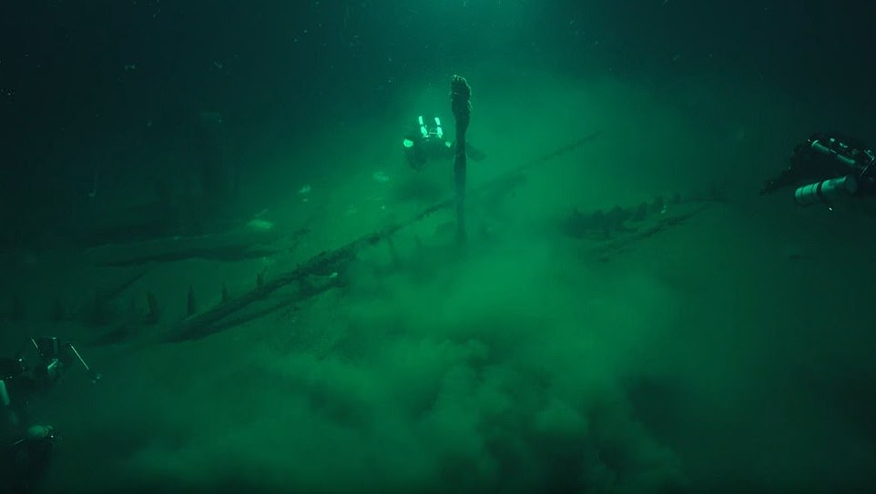
The ship lies in over 1.3miles of water, deep in the Black Sea where the water is anoxic (oxygen free) which can preserve organic material for thousands of years. A small piece of the vessel has been carbon dated and it is confirmed as coming from 400BC – making the ship the oldest intact shipwreck known to mankind. Jon Adams, the project’s chief scientist, said the wreck was very well-preserved, with the rudder and tiller still in place.
‘A ship, surviving intact, from the Classical world, lying in over 2km of water, is something I would never have believed possible,’ he said
‘This will change our understanding of shipbuilding and seafaring in the ancient world.’
Prior to this discovery ancient ships had only been found in fragments with the oldest more than 3,000 years old. The team from the Black Sea Maritime Archaeological Project said the find also revealed how far from the shore ancient Greek traders could travel. Adams told The Times the ship probably sank in a storm, with the crew unable to bail water in time to save it.
Ulysses and the Sirens in another piece of Greek artwork
The archaeologist believes it probably held 15 to 25 men at the time whose remains may be hidden in the surrounding sediment or eaten by bacteria. He said he plans to leave the ship on the seabed because raising it would be hugely expensive and require taking the pint joints apart.
The ship was both oar and sail-powered. It was chiefly used for trading but the professor believes it may have been involved in ‘a little bit of raiding’ of coastal cities. It was probably based at one of the ancient Greek settlements on what is now the Bulgarian coast.
He said: ‘Ancient seafarers were not hugging the coast timidly going from port to port but going blue-water sailing.’
The find is one of 67 wrecks found in the area. Previous finds were discovered dating back as far as 2,500 years, including galleys from the Roman, Byzantine and Ottoman empires. Scientists stumbled upon the graveyard while using underwater robots to survey the effects of climate change along the Bulgarian coast. Because the Black Sea contains almost no light or oxygen, little life can survive, meaning the wrecks are in excellent condition.
Researchers say their discovery is ‘truly unrivalled’.
Many of the ships have features that are only known from drawings or written description but never seen until now. Carvings in the wood of some ships have remained intact for centuries, while well-preserved rope was found aboard one 2,000-year-old Roman vessel. The project, known Black Sea Maritime Archaeology Project (Black Sea MAP), involves an international team led by the University of Southampton’s Centre for Maritime Archaeology. Ed Parker, CEO of Black Sea MAP, said: ‘Some of the ships we discovered had only been seen on murals and mosaics until this moment.
The ship lies in over 2km of water, deep in the Black Sea where the water is anoxic (oxygen free) which can preserve organic material for thousands of years.
‘There’s one medieval trading vessel where the towers on the bow and stern are pretty much still there.
‘It’s as if you are looking at a ship in a movie, with ropes still on the deck and carvings in the wood.
‘When I saw that ship, the excitement really started to mount – what we have found is truly unrivalled.’
Most of the vessels found are around 1,300 years old, but the oldest dates back to the 4th Century BC. Many of the wrecks’ details and locations are being kept secret by the team to ensure they remain undisturbed. Black Sea water below 150 metres (490 ft) is anoxic, meaning the environment cannot support the organisms that typically feast on organic materials, such as wood and flesh.
The wrecks, such as this one from the Medieval period, are astonishingly well preserved due to the anoxic conditions (absence of oxygen) of the Black Sea below 150 metres (490 ft). This trading vessel was found with the towers on the bow and stern still mostly in place
Shown here is a shipwreck from the Ottoman period discovered 300 metres beneath the Black Sea. Many of the wrecks’ details and locations are being kept secret by the team to ensure they remain undisturbed
The researchers used two Remotely Operated Vehicles (pictured) to survey the sea bed. These have discovered a number of wrecks over a series of expeditions spanning three years, including the one pictured from the Byzantine period, found in October last year
As a result, there is an extraordinary opportunity for preservation, including shipwrecks and the cargoes they carried. Ships lie hundreds or thousands of metres deep with their masts still standing, rudders in place, cargoes of amphorae and ship’s fittings lying on deck. Many of the ships show structural features, fittings and equipment that are only known from drawings or written description but never seen until now.
Project leader Professor Jon Adams, of the University of Southampton, said: ‘This assemblage must comprise one of the finest underwater museums of ships and seafaring in the world.’
The expedition has been scouring the waters 1,800 metres (5,900ft) below the surface of the Black Sea since 2015 using an off-shore vessel equipped with some of the most advanced underwater equipment in the world. The vessel is on an expedition mapping submerged ancient landscapes which were inundated with water following the last Ice Age.
While the primary focus of the project is to carry out geophysical surveys, shipwrecks, including this one from the Ottoman period, have given new insights into how communities live on the shores of the Black Sea
The researchers had discovered over 40 wrecks across two previous expeditions, but during their latest trip, which spanned several weeks and returned this month, they uncovered more than 20 new sites.
Returning to the Port of Burgas in Bulgaria, Professor Jon Adams said: ‘Black Sea MAP now draws towards the end of its third season, acquiring more than 1300km [800 miles] of survey so far, recovering another 100m (330 ft) of sediment core samples and discovering over 20 new wreck sites, some dating to the Byzantine, Roman and Hellenistic periods.’
The researchers are using two Remotely Operated Vehicles (ROVs) to survey the sea bed. One is optimised for high resolution 3D photography, while the other, called Surveyor Interceptor, ‘flies’ at four times the speed of conventional ROVs. The Interceptor carries an entire suite of geophysical instrumentation, as well as lights, high definition cameras and a laser scanner. Since the project started, Surveyor Interceptor has set new records for depth at 5,900ft (1,800 metres) and sustained speed of over six knots (7mph), and has covered 1,250 kilometres (776 miles). Among the wrecks are ships from the Roman, Ottoman and Byzantine Empires, which provide new information on the communities on the Black Sea coast.
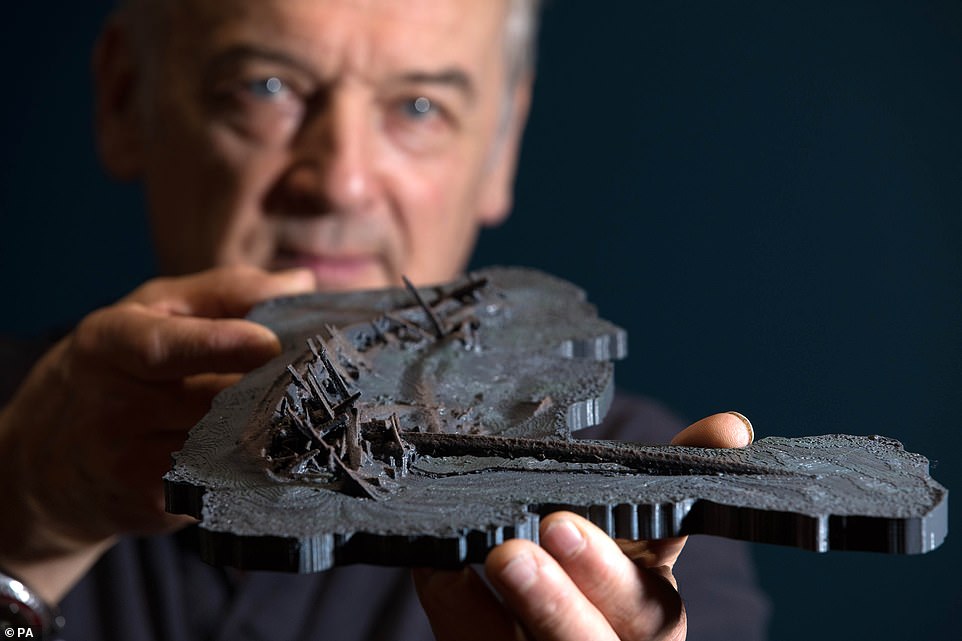
Professor Jon Adams of The Black Sea Maritime Archaeology project holding a 3D model of a Greek shipwreck from 400BC, officially the World’s oldest intact shipwreck, at the Wellcome Collection, London.
After three years of highly advanced technological mapping of the Black Sea bed, scientists confirm that a shipwreck lying intact on the sea floor has been officially radiocarbon dated to 400BC
Many of the colonial and commercial activities of ancient Greece and Rome, and of the Byzantine Empire, centred on the Black Sea. After 1453, when the Ottoman Turks occupied Constantinople – and changed its name to Istanbul – the Black Sea was virtually closed to foreign commerce. Nearly 400 years later, in 1856, the Treaty of Paris re-opened the sea to the commerce of all nations.
The scientists were followed by Bafta-winning filmmakers for much of the three-year project and a documentary is expected in the coming years. Producer Andy Byatt, who worked on the David Attenborough BBC series ‘Blue Planet’, said: ‘I think we have all been blown away by the remarkable finds that Professor Adams and his team have made.
‘The quality of the footage revealing this hidden world is absolutely unique.’
Oldest evidence of humans in Greece is 700,000 years old, a quarter of a million years older than previous record
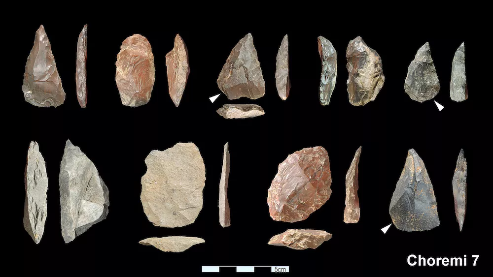
Stone tools crafted by hominins from and Choremi 7 in Greece.
Several prehistoric sites in Greece reveal that our human ancestors hunted hippos and elephants between 280,000 and 700,000 years ago. The oldest site pushes back the earliest known hominin presence in the region by up to 250,000 years.
It’s not clear which ancient hominin (a term that includes humans and our ancestors) used the site, but researchers suspect it was archaic Homo sapiens.
Sitting about 124 miles (200 kilometers) southwest of Athens, the Megalopolis Basin in Arcadia hosts one of the largest lignite mines in Greece. Although archaeologists have known for decades that the site harbored ancient fossils, little targeted excavation had been carried out.
Recently, though, the Hellenic Ministry of Culture & Sports and the American School of Classical Studies at Athens launched a five-year excavation to better understand the context of the Megalopolis sites.
Mining activity revealed five new sites in the basin, which “exposed the fossil-bearing sediments to a much greater depth, thus revealing older remains,” Katerina Harvati, a paleoanthropologist at the University of Tübingen in Germany and co-project lead, told Live Science in an email.
The most recent site, Choremi 7, dating to around 280,000 years ago, yielded stone tools as well as deer bones with evidence of cut marks. Tripotamos 4, at 400,000 years old, had a large concentration of stone tools and evidence of new methods of stone working compared to older sites.
These sites are important for understanding the technological development of the Lower Paleolithic period (3.3 million to 300,000 years ago), according to a statement from the Hellenic Ministry of Culture & Sport.
At a site called Marathousa 2 dating to 450,000 years ago, the researchers discovered evidence that ancient human relatives were killing and presumably eating hippopotamuses, as part of a hippo skeleton had stone tool cut marks on it. A nearby site, Marathousa 1, shows evidence of elephant butchering.
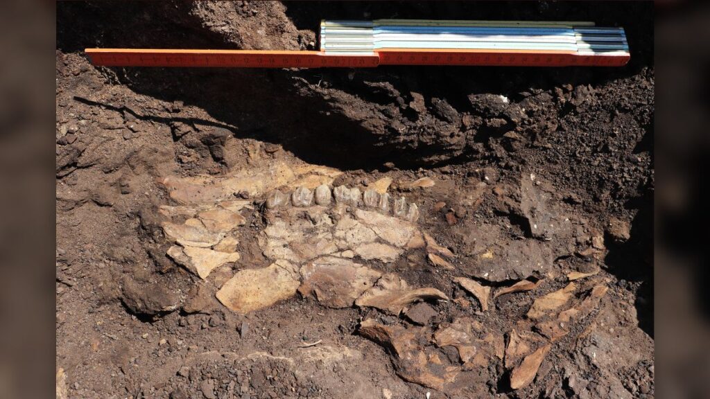
An ancient deer skull, as found at Kyparissia site 4.
“The cut marked hippopotamus bones from Marathousa 2, which were also found together with a lithic artifact, are the only such findings from the Middle Pleistocene of southeast Europe,” Harvati said. The team found that megafaunal exploitation was likely common during this time period.
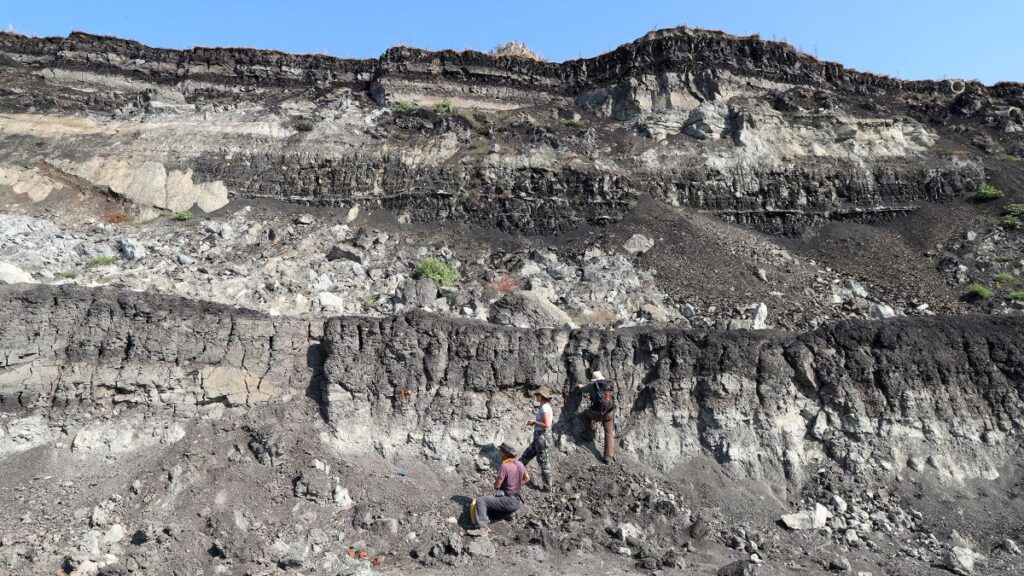
A surface survey showing the artificial levels of the Megalopolis lignite mine in Greece.
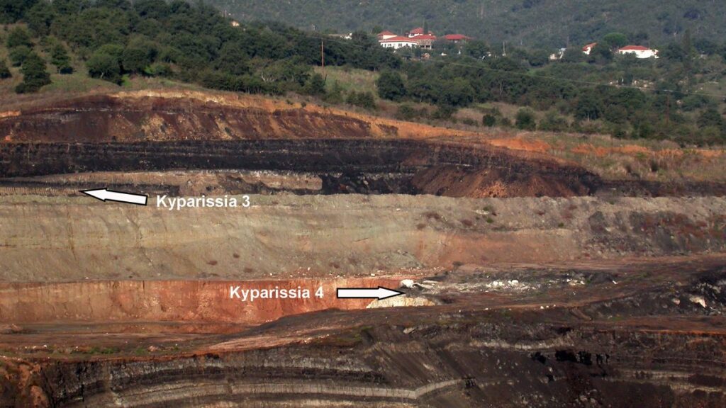
About 230 feet (70 meters) below the surface, the team discovered the site of Kyparissia 4. Dating to 700,000 years ago, it is the oldest archaeological site from the Lower Palaeolithic era in Greece.
The researchers found numerous stone tools as well as remains of extinct species of giant deer, hippo, rhino, elephant and macaque. When glaciers covered much of Europe during a major ice age between 500,000 and 300,000 years ago, this region would have been ice-free.
The sites Kyparissia 3 and 4 in the stratigraphic sequence of the lignites.
“Our research reconstructing the paleoenvironment of the basin has indicated that it would have functioned as a refugium during Ice Age conditions,” Harvati said, “allowing animal and plant populations — but also hominin groups — to survive during harsh glacial times when they would have disappeared from more northern parts of the European continent.”
The “outstanding and highly unusual preservation conditions” in the Megalopolis basin mean that the team is recovering not only stone tools and fossils but also remains of small animals, wood, plant remains and even insects, according to Harvati.
The basin has provided evidence that spans almost the entire middle Pleistocene, an important discovery considering southeastern Europe is relatively unexplored for this time period.
“The Megalopolis basin therefore provides a crucial piece of the puzzle of human evolution in Europe,” Harvati said.