Beaver fur was a symbol of wealth and an important trade item in 10th Century Denmark, according to a study published July 27, 2022, in the open-access journal PLOS ONE by Luise Ørsted Brandt of the University of Copenhagen and colleagues.
Written sources indicate that fur was a key commodity during the Viking Age, between 800-1050 CE, but fur doesn’t often survive well in the archaeological record, so little direct evidence is available.
Previous reports have used the microscopic anatomy of ancient fur to identify species of origin, but this method is often inexact. All in all, not much is known about the kinds of furs the Vikings preferred.
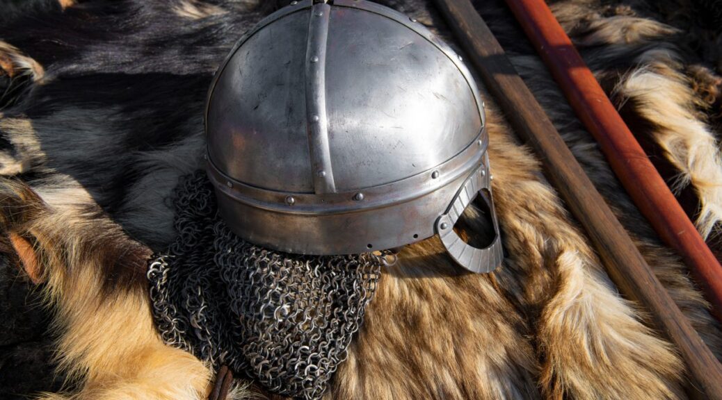
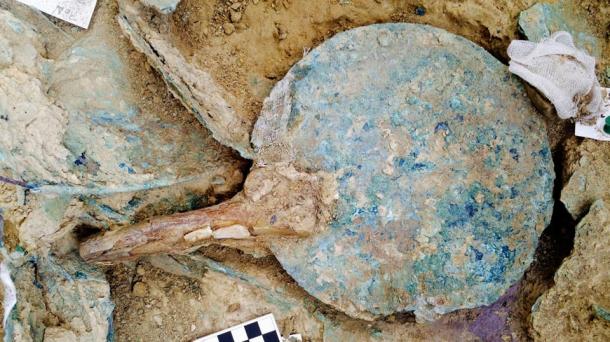
Map of studied sites (a) and examples of included fur: b) Hvilehøj C4273-97, fragment 1, c) Hvilehøj C4280c, d) Bjerringhøj C143. Graphics: Luise Ørsted Brandt and Charlotte Rimstad.
In this study, Brandt and colleagues analyzed animal remains from six high-status graves from 10th Century Denmark.
While no ancient DNA was recovered from the samples, perhaps due to treatment processes performed on furs and skins and probably due to preservation conditions, identifiable proteins were recovered by two different analytical techniques.
Grave furnishings and accessories included skins from domestic animals, while clothing exhibited furs from wild animals, specifically a weasel, a squirrel, and beavers.
These findings support the idea that fur was a symbol of wealth during the Viking Age.
The fact that beavers are not native to Denmark suggests this fur was a luxury item acquired through trade.
Some clothing items included fur from multiple species, demonstrating a knowledge of the varying functions of different animal hides, and may have indicated a desire to show off exclusive furs.
The authors note the biggest limiting factor in this sort of study is the incompleteness of comparative protein databases; as these databases expand, more specific identifications of ancient animal skins and furs will be possible.
The authors add: “In the Viking Age, wearing exotic fur was almost certainly an obvious visual statement of affluence and social status, similar to high-end fashion in today’s world.
This study uses ancient proteins preserved in elite Danish Viking burials to provide direct evidence of beaver fur trade and use.”
Neolithic Tomb Linked to King Arthur Investigated in England
High above one of western Britain’s loveliest valleys, the silence is broken by the sound of gentle digging, scraping and brushing, along with bursts of excited chatter as another ancient feature is revealed or a curious visitor stops by to find out what is going on.
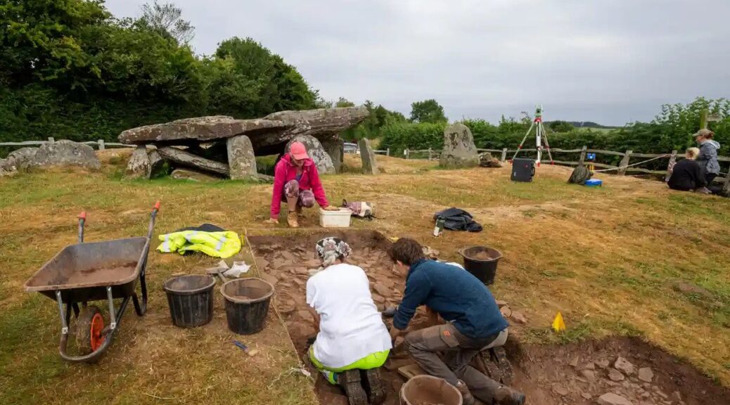
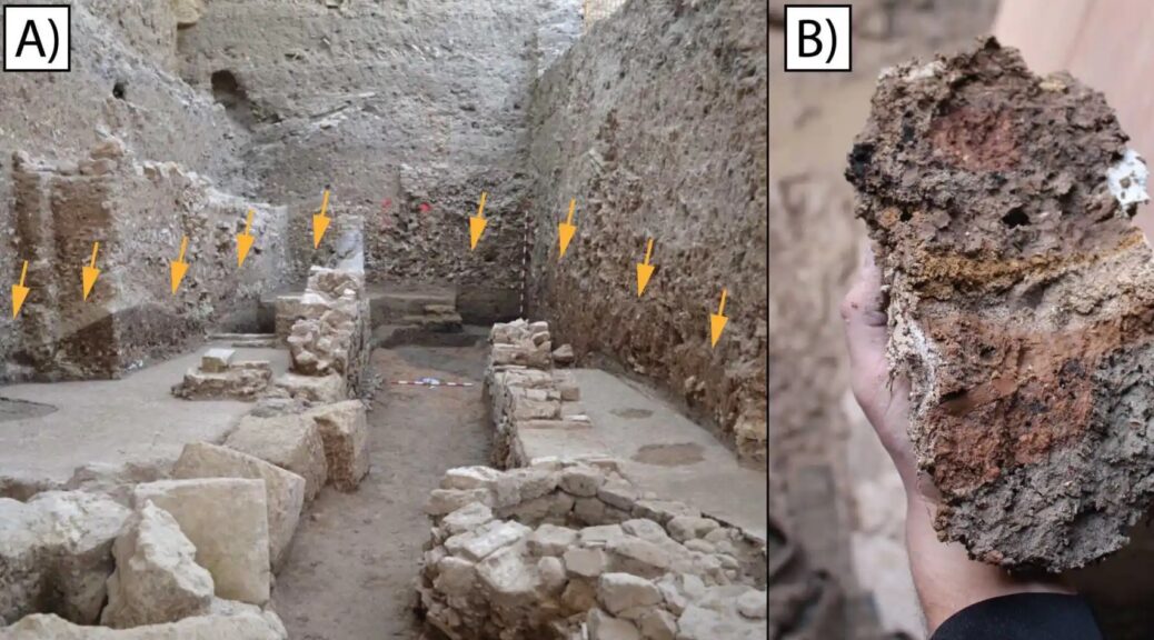
Archaeologists digging at Arthur’s Stone, Herefordshire, thought it to be an important neolithic meeting place like Stonehenge and Avebury.
This summer archaeologists have been granted rare permission to excavate part of the Arthur’s Stone site, a neolithic burial plot with soaring views across the Golden Valley in Herefordshire and the Black Mountains of south-east Wales.
Using their version of keyhole surgery, the archaeologists unearthed features, including what appear to be stone steps leading up to the 5,000-year-old tomb, and tools used by the first people to farm this landscape.
The 25-strong team have launched drones that have pinpointed possible sites of several other ancient burial spots nearby, all of which are leading them to surmise that Arthur’s Stone – like the circles at Stonehenge and Avebury – was an important meeting place and possibly part of a much larger complex of inter-related monuments.
Julian Thomas of Manchester University at the dig site.
“Arthur’s Stone is one of the most wonderful ancient monuments in the care of the nation but it’s been very poorly understood,” said Julian Thomas, a professor of archaeology at the University of Manchester, who is leading the dig. “We’re trying to do justice to it, put it in the context of what was happening in the very early neolithic.”
Over the centuries the site has inspired storytellers as well as archaeologists and historians. King Arthur was said to have killed a giant on the spot; indentations on the surface of the tomb’s capstone were supposedly made by the creature’s elbows as it fell backwards.
In the 20th century, CS Lewis is said to have used the monument as the inspiration for the stone table on which Aslan is sacrificed in The Lion, the Witch and the Wardrobe.
Thomas said the true story emerging was of a monument developed over many decades or centuries in the very early neolithic period by the first farmers and last hunter-gatherers.
He said it was becoming clear that it was almost certainly connected to two other nearby sites, Dorstone Hill, where prehistoric halls were burned and incorporated into burial mounds, and a long barrow at Cross Lodge.
The site has views across the Golden Valley in Herefordshire and the Black Mountains of southeast Wales.
The site also seems oriented towards a mountain on the horizon across the border in Wales called the Skirrid, another place steeped in myth and legend, where a landslide was said to have been caused by an earthquake or lightning strike at the moment of the crucifixion of Jesus Christ.
Keith Ray, an honorary professor of archaeology at Cardiff University, who is also overseeing the digging, said he had been asking people to look afresh at the Skirrid and imagine what it may have meant to ancient people. “I’ve thrown out one idea, it’s a bit wacky, but could it have looked like a mammoth to them and reminded them of this giant creature that used to roam here.”
Visitors have flocked to the dig from near and far. Ben Hughes, a musician based in Cardiff, said he found the site “strange, weird, wonderful, fascinating”. He said: “For me it feels like an in-between sort of place, with the more gentle landscape behind and the mountains over there. I can see why people have met here for centuries.”
Pam Thom-Rowe, an English Heritage volunteer guide, said visitors from as far away as Texas had been on site. “To me it feels like the monument is putting feelers out on the landscape.”
Thomas examines uncovered stones, and evidence of a wall around the site.
Such is the excitement at what is being found – and the public response – that the chief executive of English Heritage, Kate Mavor, is paying a visit on Friday. She said new archaeology and research continued to find fresh stories.
“Exploring a site like Arthur’s Stone is a fascinating process and something we wanted to open up to the public,” she said. “We’ve had a great response.”
Keeping an eye on the dig was Win Scutt, a properties curator at English Heritage. He said it was rare for permission to be given for this type of exploration within a scheduled monument. “This is very delicate, targeted keyhole sampling to try to answer specific questions,” he said.
Scutt said ideas about what the site was all about had changed immensely over the past few weeks – making the details on the English Heritage interpretation board out of date. “But I won’t be in too much of a rush to change it. The story will be different next year and the year after that. Which is the very exciting thing.”
Helle’s Toilet: Three-Person Loo Seat was Unusual Medieval Status Symbol
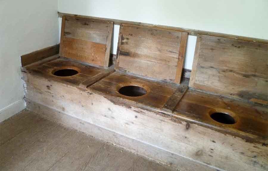
A rare 12th-century toilet seat built to accommodate three users at once is to go on display for the first time at the Museum of London Docklands.
Conservator Luisa Duarte working on the 12th-century toilet seat.
Nine hundred years after the roughly carved plank of oak was first placed over a cesspit near a tributary of the Thames, it will form the centrepiece of an exhibition about the capital’s “secret” rivers.
The strikingly well-preserved seat, still showing the axe marks where its three rough holes were cut, once sat behind a mixed commercial and residential tenement building on what is now Ludgate Hill, near St Paul’s Cathedral, on land that in the mid-1100s would have been a small island in the river Fleet.
Remarkably, archaeologists have even been able to identify the owners of the building, which was known at the time as Helle: a capmaker called John de Flete and his wife, Cassandra.
“So what I love about this is that we know the names of the people whose bottoms probably sat on it,” said Kate Sumnall, the curator of archaeology for the exhibition.
Axe marks are visible where the seat’s three rough holes were cut.
They would probably have shared the facilities with shopkeepers and potentially other families who lived and worked in the modest tenement block, she said. “This is a really rare survival. We don’t have many of these in existence at all.”
Around 50 small rivers and tributaries of the Thames are known, according to Sumnall, many of which, including the Fleet, Westbourne, Effra and Tyburn, have now been routed underground. But their influence on the topography of London has been significant, and their banks, bends and islands can still be identified in the capital’s slopes and bumps. “No one perfectly flattens the land before building the next stage,” she said.
Among the other artefacts going on display is a late bronze age sword dating from 1000BC, two Viking battleaxes and a 14th-century iron sword found in Putney, all of which appear barely corroded despite having spent centuries buried in mud.
Also on display will be a late 18th-century copper alloy dog collar, inscribed to “Tom, of the Gray Hound, Bucklers Bury” – a street close to what is now Bank – which was also excavated from the Fleet.
“We are very lucky in London that we tend to get really great preservation of a lot of things from the river,” said Luisa Duarte, the archaeological conservator.
Thanks to the low-oxygen environments of the waters and surrounding muds, she said, “in the case of the metals we have very low corrosion, and in organics, we have a very low biological activity. That’s why in London we have so much wood and leather – sometimes we have more organic Roman material than in Rome.”
The toilet seat was first excavated in the 1980s as part of what was, at the time, the largest archaeological dig in London. But because the money ran out, the findings were never published, which is why the seat has never gone on display before now.
The museum has commissioned a replica, which will form part of the exhibition and which visitors will be invited to try.
Sumnall said it was quite comfortable, but were three people to use at once “I imagine you would be touching shoulders, which would be slightly awkward.”
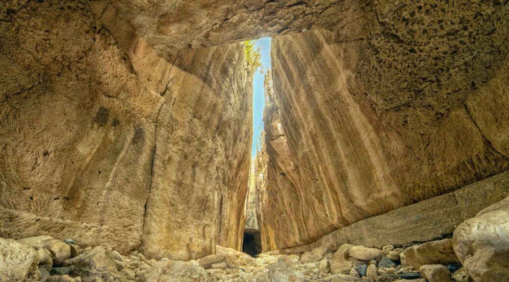
The ancient Roman Titus Tunnel, in the Samandağ district of Hatay, Turkey.
In the Samandağ district of southern Turkey’s Hatay province, the Vespasianus Titus Tunnel, or simply the Titus Tunnel, is a magnificent ancient structure constructed by 1,000 slaves to prevent floodwaters in the area, has been garnering particular attention from tourists.
The Titus Tunnel was a mega project 2,000 years ago carved into the mountain, and it still stands as an unbelievable engineering marvel.
The tunnel, which was built to prevent floodwaters that carried sand and gravel down the mountains from filling the city’s harbour and threatening it, was first conceived by the Roman Emperor Vespasian, who started its construction in A.D. 69. Its construction continued during the reign of his successor and son Emperor Titus and in the times of his other successors.
The ancient Roman Titus Tunnel, in the Samandağ district of Hatay, Turkey.
It was finally completed during the era of Antoninus Pius in the second century. It was built by digging the rocks using human resources only.
The tunnel is part of a water diversion system consisting of a dam, a short approach channel, the first tunnel section, a short intermediary channel, the second tunnel section and a long discharge channel.
It hosts an inscription elegantly carved into the rock at the first tunnel entrance that reads the names of Vespasianus and Titus, while there is another one at the discharge tunnel for Antonious.
Ancient structures near the Roman Titus Tunnel, in the Samandağ district of Hatay, Turkey.
It stands today as a must-see site for anyone that visits Hatay as it takes visitors on a wonderful journey through time. The tunnel is 1,380 meters (4,527 feet) long with a height of 7 meters and a width of 6 meters, attracting admiration from local visitors and abroad with its architecture in the middle of nature.
The tunnel is part of a water diversion system consisting of a dam, a short approach channel, the first tunnel section, a short intermediary channel, the second tunnel section and a long discharge channel.
It is located at the foot of the Nur Mountains, near the modern village of Çevlik, 7 kilometres (4.3 miles), northwest of central Samandağ (the medieval port of Saint Symeon) and 35 kilometres southwest of Antakya.
The ancient Roman Titus Tunnel, in the Samandağ district of Hatay, Turkey.
Beşikli Cave where 12 rock tombs are located near the ancient Roman Titus Tunnel, in the Samandağ district of Hatay, Turkey.
Beşikli Cave is also right next to the tunnel, standing only 100 meters away, boasting a particularly flashy architectural structure and decoration. In the cave, there are tombs from the ancient Roman period, believed to belong to a nobleman and his family.
Those who come to visit the tunnel also get the chance to see the tomb chambers here.
Ayşe Ersoy, director of the Hatay Archaeology Museum, said that it was evident from these sites as well that Hatay occupied a significantly important historical and cultural value.
Ersoy stated that the city had hosted several civilizations throughout its history and that now it was receiving great interest from both domestic and foreign visitors. She noted that the Titus Tunnel was one of the most remarkable places in the city.
She also said that the number of visitors to the tunnel was increasing day by day.
Beşikli Cave where 12 rock tombs are located near the ancient Roman Titus Tunnel, in the Samandağ district of Hatay, Turkey.
The path between high stone walls to the ancient Roman Titus Tunnel, in the Samandağ district of Hatay, Turkey.
“The 1,380-meter-long Titus Tunnel, an important Roman ruin of our city, takes its visitors on a journey in time,” Ersoy said and added, “More than 28,000 local and foreign visitors have been to Titus Tunnel over the last eight months in Samandağ.”
Cafer Tayyar Demirci, who came from Gaziantep, said, “Titus Tunnel is a place of a natural wonder; everyone should definitely stop by here.”
Celal Karadavut, who came from Mersin to visit the tunnel with his family, said that Hatay is an important city that has left its mark on history.
Karadavut stated that he was pleased to visit the city that has hosted many civilizations. “Hatay is a city that has a different place in Turkey both in terms of history, nature and gastronomy,” he said.
Şükran Naz Karadavut also noted that she liked the tunnel very much and that everyone should see it.
Archaeologists unearth a 3,500-year-old warrior’s grave in Greece
An undated picture released on October 26, 2105, by the Greek Culture Ministry shows an ivory comb, one of the items found in a 3,500 years old warrior tomb unearthed in the Peloponnese region of Greece
Archaeologists in Greece have made a rare and exciting discovery – an ancient unlooted tomb with the remains of an unknown warrior and a huge hoard of treasure. The Greek Ministry of Culture announced that it is the most important treasure to have been discovered in 65 years.
The Ministry of Culture announced the finding today, revealing that two US archaeologists, Jack L. Davis and Sharon R. Stocker from the University of Cincinnati, made the discovery while excavating the 3,500-year-old Palace of Nestor on Greece’s Peloponnese peninsula.
The Palace of Nestor, located at the top of the hill of Epano Englianos, near Pylos, is the best preserved Mycenaean Greek palace discovered. It once consisted of a two-storey building with reception rooms, baths, workshops, store rooms, and an established sewage system.
Photo of Nestor’s Palace taken in 2010.
The tomb, which measures 2.4 meters in length and 1.5 meters in width, was discovered on the site of the palace complex.
However, it had been placed there many years before the palace was built. Surprisingly, the tomb had not been looted in antiquity, unlike most of the other Mycenaean-era tombs found to date.
Inside the tomb, archaeologists discovered the remains of a wooden coffin containing the skeleton of an unknown warrior, aged between 30 and 35 years old.
Next to him were his weapons – a bronze sword with a gold and ivory handle and a gold-hilted dagger.
Considering his place of burial and the treasures he was buried with, he is believed to have been a person of great importance.
According to the Ministry of Culture, the treasures also included gold rings, an ornate string of pearls, 50 Minoan seal stones carved with imagery of goddesses, silver vases, gold cups, a bronze mirror, ivory combs, an ivory plaque carved with a griffin, and Minoan-style gold jewellery decorated with figures of deities, animals, and floral motifs.
A bronze mirror with an ivory handle was found in the grave of the warrior.
Many of the artefacts found in the tomb have been traced to Crete, the island upon which the Minoan civilization arose.
James C. Wright, the director of the American School of Classical Studies at Athens, told the New York Times that the finding of the tomb “will help scholars understand how the state cultures that developed in Crete were adopted into what became the Mycenaean palace culture on the mainland.”
Artefacts were recovered from the grave of the ancient warrior.
Archaeologists now plan to carry out a DNA analysis on the warrior’s remains to try to determine his origin. They also plan to carry out radiocarbon tests on the plant material recovered from the tomb, which may allow more accurate dating of the burial.
Evidence of Third-Century A.D. Tsunami Uncovered in Spain
The Seville Cathedral, as seen from Patio de Banderas Plaza.
In the 1970s, two Roman inscriptions — dated from 245 to 253 AD — were discovered in Écija (known in ancient Roman times as Astigi), a city in Spain’s southern province of Seville. The writings on the tablets suggest that the emperor at the time had exempted the Roman province of Baetica (roughly the equivalent of modern-day Andalusia, a region of southern Spain) from taxes. But the inscriptions failed to explain why, and the reason has remained a mystery for decades.
In a new study published in Natural Science in Archaeology, a team of European and U.S. scientists and researchers say they have finally found an explanation. The article, A Third Century AD Extreme Wave Event Identified in a Collapse Facies of a Public Building in the Roman City of Hispalis (Seville, Spain), provides a surprising answer: A gigantic tsunami that began in the Bay of Cadiz crashed into the land, causing numerous coastal settlements to be abandoned and engulfing everything its path, including the city of Seville, located 45 miles inland from the sea.
The discovery was made following the excavation and study of a public building from the Roman era, destroyed during what researchers now believe was a massive tidal wave event. The building once stood in what is now the Patio de Banderas public square in Seville, adjacent to the capital city’s main cathedral.
The report, authored by experts from universities in Spain, France, Germany, and the U.S. describes how, in 400 BC, the Atlantic Ocean had created a large lagoon, known in antiquity as Lacus Ligustinus, at the mouth of the Guadalquivir River.
The lake was fed by three river corridors, one of which led directly to Hispalis. The river was large enough that medium-sized ships could use it to transport minerals, oil, wine, and other goods as far inland as Alcalá del Río, roughly 10 miles past Seville. It is estimated that the Port of Seville was quite large, even at that time, stretching over a kilometer in length and moving some 18,000 tons of merchandise per year.
Between 2009 and 2014, a team of archaeologists excavated the Patio de Banderas site. “Impressive urban stratigraphy dated between the ninth century BC and the thirteenth century AD,” the report reads. “From all these findings, a very well-preserved Roman public building […] stands out. The building [was] constructed in opus africanum [a form of Roman brick masonry] during the Late Republic (60 to 30 BC).” It was organized around a central courtyard, with a gallery of columns at its southern end. Experts identified the site as a commercial and administrative space associated with the Hispalis river port.
Analyzing the ruins at the Patio de Banderas, the first team of archaeologists to study the site concluded that the ancient building had been repaired several times under the Flavian Dynasty (late 1st century AD), but especially between the years 200 and 225 AD, when there was “widespread collapse of the architectural remains [and] most of the southern walls appear to have been displaced from their original position [by an external force], always in the same direction, toward the northwest.” At the time, the archaeologists ruled out a tsunami for two main reasons: because the site is 22 feet above sea level, and because the distance between Híspalis and the Lacus Ligustinus was almost 25 miles in Roman times (now it’s more than 45 miles). In other words, for a tsunami to destroy the building, it would have had to be bigger than any on record — the mother of all tsunamis.
Remains of an ancient Roman building destroyed by a tsunami in the 3rd century AD were found inside an excavated public building in Seville, Spain.
The authors of the new report ―Mario Gutiérrez-Rodríguez, José N. Pérez-Asensio, Francisco José Martín Peinado, Enrique García Vargas, Miguel Ángel Tabales, Antonio Rodríguez Ramírez, Eduardo Mayoral Alfaro and Paul Goldberg ― were not satisfied with the first team’s findings. They believed that an opinion based on a visual analysis of the site “was not enough,” so they undertook a multidisciplinary study that combined macro- and microscale methods and techniques.
They used carbon-14 dating, micromorphology, mineralogy, geochemistry, micropaleontology, ultraviolet fluorescence microscopy, accelerator mass spectrometry, radiocarbon calibration, and ceramic and materials science, among other techniques, to re-examine the site and search for new answers.
The team of researchers began to analyze “a microlaminated deposit, alternating sandy and silty beds, and with abundant fresh-fragmented shell,” as well as brick columns, several calcarenite ashlars, plaster and paint, a fluted column, fragmented marble from different Mediterranean quarries, an inscription, and a complete marble votive relief, typical of the Cult of Isis. What was especially striking about the site, the team discovered, was that “the materials [did] not belong to the building excavated at the Patio de Banderas, since it was constructed with different materials (mainly limestone and brick) and different techniques.” Rather, these exogenous architectural elements had been chemically transformed by a “highly energetic event,” which transported them to the Patio de Banderas, where they were trapped inside the building due to flooding from the tsunami.
The report calculates that the flooding occurred between the years 197 and 225.
The courtyard of the public building was destroyed by the tsunami in Hispalis.
Among the objects excavated at the site was an inscription reading “IIAVRHERACLAE / PATETFILFBAR AVR HERACLAE/ PAT ET FIL / F BAR.” The artefact was originally fabricated in a ceramics workshop owned by Roman emperors Septimius Severus, Antonino Caracalla, and Geta, which once stood on the banks of the Guadalquivir River.
The inscription references Aurelii Heraclae, the family of freedmen who managed the workshop between 197 and 207 AD — the same period from which the other artefacts found on the site date.
On the left, are fragments of paintings and marble; in the centre, a votive plaque dedicated to the goddess Isis; on the right, a close-up of a piece of marble.
The study thus concludes that “the Patio de Banderas deposit was generated during an extreme wave event,” and that the building acted as a trap for the artefacts transported inland by the tsunami. “With the data, we actually have, and considering the distance at this point from the coast in Roman times [about 25 miles], and also taking into account the distance from this point to the coast in Roman times [about 40 kilometres], we affirm that the most probable origin of the deposit identified is the combined action of an energetic storm, which might have produced waves and currents in the Lacus Ligustinus energetic enough to transport estuary and marine fauna, together with extreme rainfall and flooding from the Guadalquivir River.”
These new findings suggest an answer to the mystery posed by the inscriptions found in Écija that indicate Baetica’s status as prouincia immunis — a province exempt from taxes. As the authors of the Patio de Banderas study note, this status was most commonly granted in the aftermath of natural disasters. Like, as an example, a tsunami.
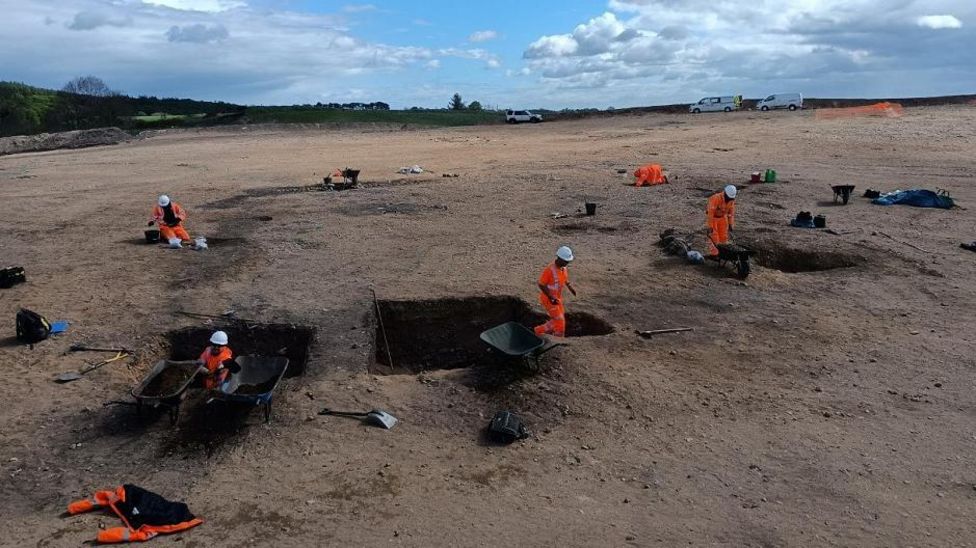
A metal-working site uncovered in Moray may have helped arm Caledonian tribes against the Romans, before being burned down by the invaders. Archaeologists have described the site at Lochinver Quarry, near Elgin, as fascinating and unusual.
Archaeologists have found evidence of extensive metal production near Elgin
Evidence has been found of metal production over a period of up to 2,000 years from the Bronze Age through the Iron Age.
Archaeologists believe they could end up excavating as many as 40 iron smelting sites.
Prior to these discoveries around 25 such sites have been found in the whole of Scotland. Lochinver appears to have been abandoned suddenly and homes and other structures burned down.
Archaeologists suggest one possible explanation could be that it may have been the actions of Roman soldiers following their victory over Caledonians at the Battle of Mons Grapius around AD 83.
The site may have been used over a period of 1,500 to 2,000 years
Dr Clive Waddington, of Archaeology Research Services Ltd, said the evidence being found at Lochinver made it different from Moray’s other Bronze Age and Iron Age sites.
He said the later metal-working could possibly have been in response to the Roman invasion of Scotland, with iron needed for weapons.
Dr Waddington added: “Something happens on this site that removes any further activity.
“We have got these burnt timbers and abandoned pits for making charcoal.
“We have got pits with roasted ore – a valuable commodity – ready for smelting but just abandoned.”
Two cauldrons have also been found buried, possibly by the Lochinver’s residents in an effort to hide the highly valued items.
Dr Waddington said it was possible Lochinver was abandoned in the aftermath of Mons Grapius which saw Roman troops and cavalry defeat 30,000 Caledonians.
Suggested locations of the battle include Dunning in Perthshire, Carpow in Fife, Bennachie in Aberdeenshire and Culloden in the Highlands.
Dr Waddington said: “The battle was a big victory for the Romans and could explain why some sites were burned down, with Romans torching sites as they came through after the battle.”
Archaeologists have described Lochinver Quarry as fascinating and unusual
Archaeological Research Services Ltd and Aberdeenshire Council are investigating the site supported by funding from building materials company Tarmac.
The work has been further supported by various universities including radiocarbon dating at the University of Glasgow, specialist artefact conservation at the University of Durham and expert knowledge from the National Museum of Scotland.
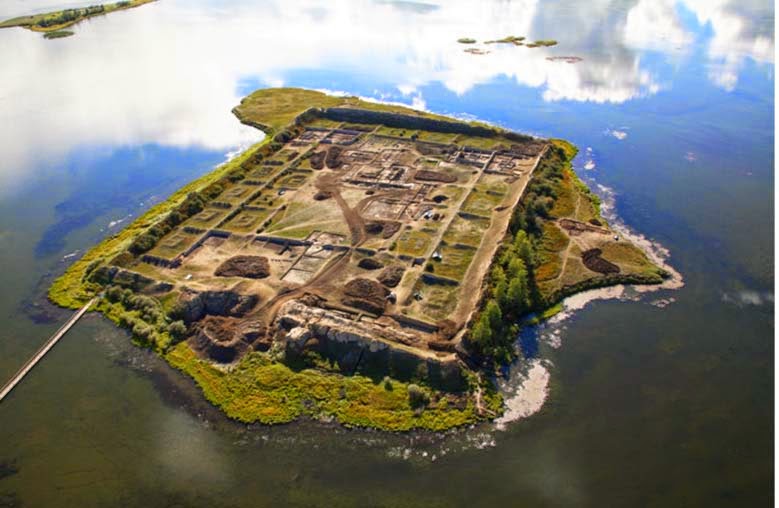
The Mysterious 1,300-Year-Old Siberian Lake Fortress
It is one of the most mysterious archaeological sites in Russia – an ancient complex engulfing a small island in the centre of a remote lake in the mountains of southern Siberia. At first glance, it appears to be an ancient fortress, its perimeter of high walls constructed to keep out enemies.
However, others have proposed the 1,300-year-old structure may have been a summer palace, monastery, memorial complex, ritual centre, or astronomical observatory.
According to the Siberian Times, more than a century after its rediscovery, experts are no closer to understanding the secrets of these enigmatic ruins.
The archaeological site is known as Por Bajin (also spelt Por-Bazhyn), meaning ‘clay house’. It is located on an island in the middle of Tere-Khol Lake in Tuva, Siberia, just 20 miles (32 km) from the Mongolian border.
First explored in 1891, the site was not excavated until 1957-1963. However, it was not until 2007-2008 that the first large-scale research was undertaken, carried out by the Por Bajin Cultural Foundation.
What they discovered presented a conundrum – the structure is located in a very remote place on the outskirts of what was the Uighur nomad empire, built with Chinese features, but with no sign of permanent habitation, and abandoned after only a short period of use.
Why was it built? How was it used? And why was it abandoned? These are the questions that have continued to both fascinate and frustrate experts ever since its discovery.
Inside the complex of Por Bajin.
The Construction of Por Bajin
Believed to have been constructed in 757 AD, the ancient complex has outer walls that still rise to 40 feet (12 meters) in height and inner walls of 3-5 feet (1 – 1.5 meters), some still covered with lime plaster painted with horizontal red stripes. The main gate was discovered, opening into two successive courtyards connected by another gate.
The walls enclose an area of about seven acres containing the remains of more than 30 buildings, but with a two-part central structure linked by a covered walkway, which once had a tiled roof and was supported by 36 wooden columns resting on stone bases.
Laser mapping of the site prior to the first major excavation in 2007 helped experts build a 3D model of what the complex might have looked like.
Por-Bajin reconstruction seen from the east.
Only a small number of artefacts were ever recovered from the site – if it had been permanently inhabited one would expect to find a much greater number of items. There was also no evidence of any kind of heating system, which would have made it impossible to stay there, at 2,300 meters above sea level, in winter conditions.
The main finds include clay tablets of human feet, faded coloured drawings, fragments of burnt wood, roof tiles, an iron dagger, a stone chalice, one silver earring, and iron construction nails. None of the artefacts provides a definitive answer as to why the structure was built, and how it was used.
One of the tiles was found at Por Bajin.
Since the end of the 19th century, Por-Bajin has been linked to the Uighur Khaganate nomadic empire (744 – 840 AD), composed of nomadic Turkic-speaking people held together by forces of warriors on horseback. The empire spanned Mongolia and southern Siberia, however, the location of Por Bajin was still well away from settlements and trade routes.
Why would they build in such a remote location? Could it have been the site of a palace or a memorial for a ruler? The unique layout, more ornate than that of other Uighur fortresses of the period, has led some scholars to suggest that it might have had a ritual role.
Still, there are some other puzzling features. The architecture reflects a distinctive Chinese style, as evidenced by the use of Chinese building materials, such as certain types of roof tiles, and the use of Chinese construction methods.
The layout, with its axial planning, dominant central building, and residential quarters is consistent with styles seen in other Buddhist monasteries. But Por-Bajin shows no evidence of religious practice.
Small yards (left) running along Por-Bajin’s walls each had a building in the centre. A digital reconstruction (right) based on excavations shows that each building could have functioned as a dwelling, perhaps for monks if the site were a monastery.
Why was it abandoned?
Not only has Por Bajin presented a mystery regarding its purpose, but archaeological evidence suggests it was abandoned after only a short period of use.
No evidence has been found to suggest the complex came under attack from an opposing force. Political changes in the region may offer one possible explanation, although nothing concrete has been presented to support this theory.
According to Dmitriy Subetto, from the Department of Physical Geography RGPU, the structure may have been abandoned prior to completion due to the builders’ lack of familiarity with the permafrost.
For now, Por Bajin remains one of Russia’s enduring mysteries.