Archaeology breakthrough: Second ‘hidden pyramid’ discovered inside iconic Mayan structure
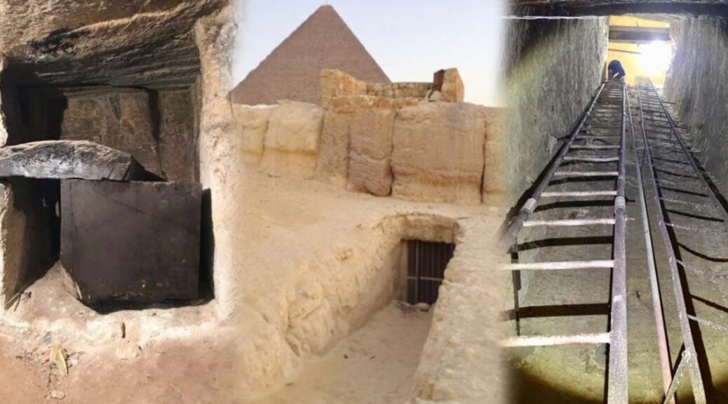
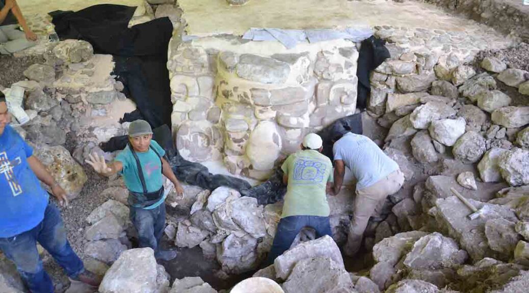
Archaeologists have confirmed that the massive Kukulkan pyramid in eastern Mexico – one of the most iconic pyramids in the world – was built like a Russian nesting doll, with the discovery of two smaller pyramids hidden within its walls.
The first of the hidden pyramids was discovered back in the 1930s, built within the walls of the colossal Kukulkan tomb. Now an even smaller pyramid has been found inside that one – and the discoveries might not stop there.
“To make matters more complicated, the third Russian doll moving in may actually be one of a set of several small dolls rattling around inside the same shell.
Ancient Mayan pyramid in Chichen Itza
We just do not know,” anthropologist Geoffrey Braswell from the University of California, San Diego, who was not involved in the study, told The Associated Press. Built sometime between the 9th and 12th centuries, the Kukulkan pyramid is the centrepiece of the vast Chichen Itza complex in the Mexican state of Yucatán.
Also known as El Castillo (meaning “the castle”), this colossal pyramid features 364 steps – one for every day of the year in the Maya calendar system – and stands 24 metres (79 feet) tall. A 6-metre-high (20-foot) temple sits on top of the pyramid and was dedicated to the featured serpent god, Kukulkan.
Back in 1931, archaeologists began investigating the insides of the pyramid, with suspicions that it could be hiding the remains of a much older version – something that was widely disbelieved at the time.
Over the course of the next five years, they discovered a room nicknamed the hall of offerings, containing a giant Chacmool statue, its nails, teeth, and eyes inlaid with mother of pearl.
They also found a room called the chamber of sacrifices, containing two carefully arranged rows of human bones, and an elaborate red jaguar statue, encrusted with 74 jade inlays for spots, and jade-studded eyes.
The researchers soon realised that there was a larger, much older pyramid hidden below and inside the Kukulkan pyramid, and it stands roughly 33 metres tall (108 feet).
Now, archaeologists have completed their latest investigation of that internal pyramid using a non-invasive imaging technique called tri-dimensional electric resistivity tomography, and report the discovery of a 10-metre-tall (33-foot) pyramid hidden inside the larger two.
At this stage, it’s not clear if this the same structure archaeologists detected back in the 1940s but couldn’t confirm – or something else entirely.
Oddly enough, it appears to have been built above a water-filled sinkhole called a cenote, which researchers detected under the Kukulkan pyramid just last year.
It’s not clear if the Maya knew of the cenote themselves, but the fact that the pyramids were built directly on top of it, and that Kukulkan was a god of water (among other things), suggests that maybe they did.
“The structure that we have found, the new structure, is not completely in the centre of the Kukulkan pyramid. It is in the direction where the cenote is,” Rene Chavez Segura, from the National Autonomous University of Mexico, told CNN.
“This could either confirm or hypothesise that the Mayans when they built this structure that they knew of the existence of this cenote.”
According to Segura and his team, the smallest pyramid was likely built between 550 and 800 AD. The middle structure has between 800 and 1000 AD, while the outer one was finished between 1050 and 1300 AD.
The researchers are yet to publish their findings, so these dates and the pyramid’s structure will still need to be verified by independent teams, but it’s hoped that further investigations will continue, so we can figure out if there are even more pyramids hidden inside.
“If this could be investigated in the future, this structure would be significant, because it would speak to the first few periods of habitation of the site and would provide information about how the settlement developed,” Denisse Argote from Mexico’s National Institute of Anthropology and History told CNN.
Researchers Discover Fossils Of A Unique ‘Eagle Shark’ That Glided Through Seas About 93 Million Years Ago!
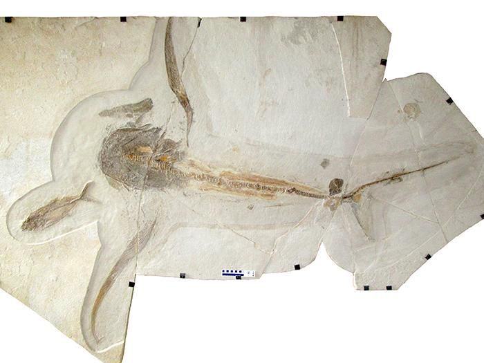
The eagle shark was probably not as fearsome as its name suggests. The ancient shark, described on March 19 in the journal Science, was most likely a slow-moving filter feeder that looked like a cross between a standard shark and a manta ray.
The eagle shark’s long, slender side fins are one of its “most striking features,” says first author Romain Vullo.
But the eagle shark lived about 95 million years ago, 30 million years before modern rays appeared in the ocean. The find has palaeontologists wondering if other ancient sharks took unusual shapes since many are known only by the teeth they left behind.
The eagle shark, or Aquilolomna milarcae, fossil has the opposite appearance: an entire skeleton, but no teeth were preserved that would have helped palaeontologists categorize it.
The researchers took signs from other aspects of its anatomy—like its broad head and wide, wing-like fins—to draw conclusions about the shark’s behaviour.
“As this shark probably fed on plankton, it didn’t need to go fast,” says Romain Vullo, first author of the new study and a palaeontologist at the Université de Rennes, to New Scientist’s Adam Vaughan. “Like modern manta rays, relatively slow swimming was enough to eat plankton.”
The eagle shark’s broad head, wide fins, and lack of dorsal and pelvic fins make it look like a combination of a manta ray and a modern shark
A quarry worker found the unusual shark fossil in the Vallecillo limestone quarry in 2012. The region in northeastern Mexico is a well-known repository of marine fossils like ammonites, fish and marine reptiles, according to a statement.
Local palaeontologist Margarito González González learned of the discovery and set to work carefully chipping away at the stone to reveal the fossil that was preserved within, Riley Black reports for National Geographic.
“My first thoughts on seeing the fossil were that this unique morphology is totally new and unknown among sharks,” says Vullo to National Geographic.
While its head and side fins are unusual, the eagle shark’s tail and tail fins resemble those of modern sharks. So the researchers suggest that the shark probably used its tail to propel itself forward and its long side fins for stabilization. Manta rays have a different strategy, flapping their wide side fins to propel themselves forward.
“One of the most striking features of Aquilolamna is that it has very long, slender pectoral [side] fins,” writes Vullo in an email to Laura Geggel at Live Science, “This makes the shark wider than long,” because it is just over six feet wide but only about 5.4 feet long.
The fossil didn’t show signs of a dorsal fin—the notorious sign of an approaching shark that sticks up above the water—or of pelvic fins, which are on the underside of the shark. It’s not yet clear whether the eagle shark lacked these fins, or if they just didn’t fossilize, per Live Science.
The biggest mystery surrounding the eagle shark comes from the lack of teeth in the fossil. Palaeontologists rely on sharks’ teeth to identify them and figure out their evolutionary relationship to other ancient sharks.
The eagle shark might have had tiny, pointed teeth like the basking shark and the megamouth—two modern filter-feeding sharks—or taken a different strategy.
“It is truly unfortunate that no teeth were preserved in the specimen that could have allowed researchers to determine the exact taxonomic affinity of the new shark,” says DePaul University paleobiologist Kenshu Shimada to National Geographic.
For now, the research team used the shape of the fossil’s vertebrae and the skeleton of its tail fin to classify it like a shark in the order Lamniformes, which includes filter-feeding sharks, mako sharks and the great white.
Future fossilized finds and analysis of the eagle shark’s anatomy could help scientists understand the strange shapes of sharks in the distant past.
“There are a lot of unusual features described by these authors, and I have some reservations about some of their interpretations,” says Humboldt State University palaeontologist Allison Bronson, who wasn’t involved in the study, to National Geographic. “Ao I would be excited to see further investigations of this new, remarkable fossil.”
Controversial cave discoveries suggest humans reached the Americas much earlier than thought
Stone tools unearthed in a cave in Mexico indicate that humans could have lived in the area as early as about 33,000 years ago, researchers reported. That’s more than 10,000 years before humans are generally thought to have settled North America.
Archaeologists have unearthed what appear to be stone tools, including this one, in a cave in central Mexico that date as early as about 33,000 years ago.
This controversial discovery enters a new piece of evidence into the fierce debate about when and how the Americas were first populated.
“A paper like this one is really stirring up the pot,” says co-author Eske Willerslev, an evolutionary biologist at the University of Cambridge. It “will no doubt get a lot of arguments going.”
For decades, archaeologists thought the Americas’ first residents were the Clovis people — big game hunters known for their well-crafted spearpoints who crossed a land bridge from Asia to Alaska about 13,000 years ago. Recent, well-accepted archaeological discoveries suggest that North America’s first settlers actually arrived a few thousand years before the rise of the Clovis culture, by about 16,000 years ago, says Vance Holliday, an archaeologist at the University of Arizona in Tucson not involved in the new work.
If the new finds really are human tools, Holliday says, this would be the oldest evidence for a human-inhabited site anywhere in the Americas.
At Chiquihuite Cave in central Mexico, archaeologists unearthed what appear to be over 1,900 stone tools.
Using radiocarbon dating to determine the ages of charcoal, bone and other detritus surrounding the artefacts, the researchers determined that more than 200 of the tools were embedded in a layer of the earth as old as 33,150 to 31,400 years. Other artefacts were found in a layer as fresh as about 13,000 years old.
The tools, excavated from 2016 to 2017, do not resemble Clovis technology or any other stone tools found in the Americas, the researchers say.
This haul “has a lot of small blades and small flakes that were used for cutting,” says archaeologist Ciprian Ardelean of the Autonomous University of Zacatecas in Mexico.
His team also dug up squarish stone fragments that he suspects were used to make composite tools of some sort, assembled from pieces of rock stuck into wooden or bone shafts.
“People are going to disagree about whether this qualifies as evidence” of human activity, says Loren Davis, an archaeologist at Oregon State University in Corvallis not involved in the work. “These are rocks that were broken, but … people don’t have a monopoly on the physics involved with breaking rocks,” Davis says that a closer examination of the artefacts in person or via 3-D models could convince him that they are indeed relics of human craftsmanship.
Ben Potter, an archaeologist in Fairbanks, Alaska, affiliated with the Arctic Studies Center at Liaocheng University in China, is similarly “intrigued but unconvinced” that Chiquihuite Cave was an ancient human abode. He notes the crude shape of many of the artefacts, as well as the absence of other evidence — such as butchered animal remains or human DNA — that would peg the site as a human residence.
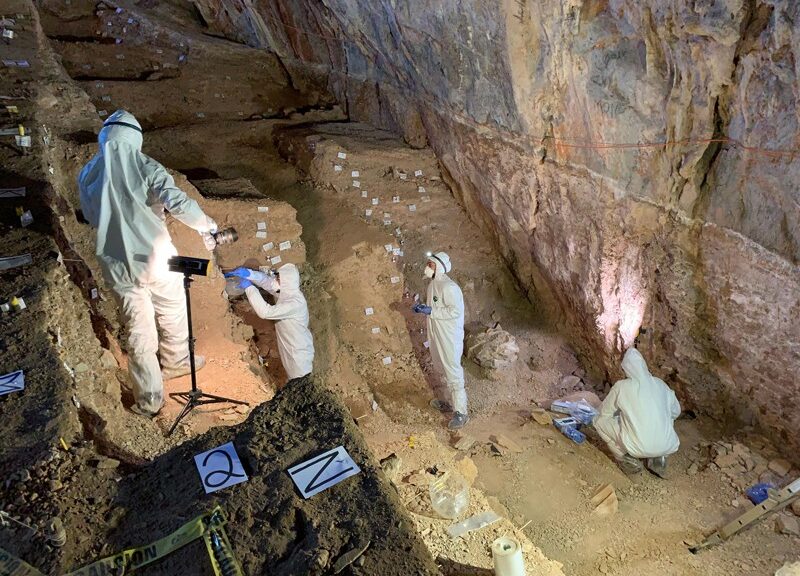
Researchers looking for ancient DNA take samples in Chiquihuite Cave, Mexico.
Neither the tools’ shape nor the apparent lack of other human-made remains disqualifies Chiquihuite Cave as an ancient dwelling, Ardelean says. He argues that archaeologists’ expectations of what North American stone tools should look like are overly influenced by the perfection of Clovis points, which were neatly chipped from brittle stone such as jasper. The limestone used by the Chiquihuite Cave dwellers was more difficult to work with, he says, so it makes sense that these implements would be more rugged.
As for corroborating evidence of human activity, Ardelean expects human DNA to turn up only in specific areas of the cave, like where people ate or relieved themselves. He and his colleagues may not have excavated those spots yet, he says. The swath of ground investigated in this dig was also far from the mouth of the cave, where ancient people would more likely have cooked, eaten, thrown out garbage and performed other daily activities, he says.
Anthropologist Ruth Gruhn of the University of Alberta in Edmonton “wasn’t a bit surprised” at the authors’ claim of 30,000-year-old human handiwork in Mexico.
This cave joins a handful of sites in Brazil that have shown evidence of human occupation more than 20,000 years ago — although those reports remain controversial. To convince many archaeologists that humans really were in the Americas so early, “what you need is an accumulation of sites of that antiquity,” says Gruhn, whose commentary on the new study appears in Nature.
If there were humans in Mexico more than 30,000 years ago, that would affect what route they could have taken south from Alaska, says geologist Alia Lesnek of the University of New Hampshire in Durham. Archaeologists have thought that if humans arrived about 16,000 years ago, they may have plodded south along the Pacific Coast.
That’s because a narrow, inland ice-free corridor between two ice sheets covering Canada would not have had enough plants or animals to sustain human travellers. But more than 30,000 years ago, those ice sheets had not yet reached their full extent, Lesnek says, opening up the possibility of inland migration.
Long Lost Early Colonial Fort Discovered in Maryland
According to a Washington Post report, archaeologist Travis Parno, archaeological geophysicist Tim Horsley, and their colleagues at Historic St. Mary’s City announced the discovery of the undisturbed outline of the palisaded fort at St. Mary’s, which was erected in southern Maryland by English colonists in 1634. Maryland archaeologist Travis Parno was at a board game convention in Philadelphia, sitting at a table surrounded by thousands of other enthusiasts when he got a text message. He was supposed to be on vacation, taking a break from his search for the legendary fort at St. Mary’s, the first permanent English settlement in Maryland and one of the earliest in what would become the United States.
Back at St. Mary’s, archaeological geophysicist Tim Horsley had been scanning a site a half-mile from St. Mary’s River with ground-penetrating radar that could detect the outlines of ancient buildings. The text message interrupting Parno’s vacation was from Horsley. It said: “I think we found it.”
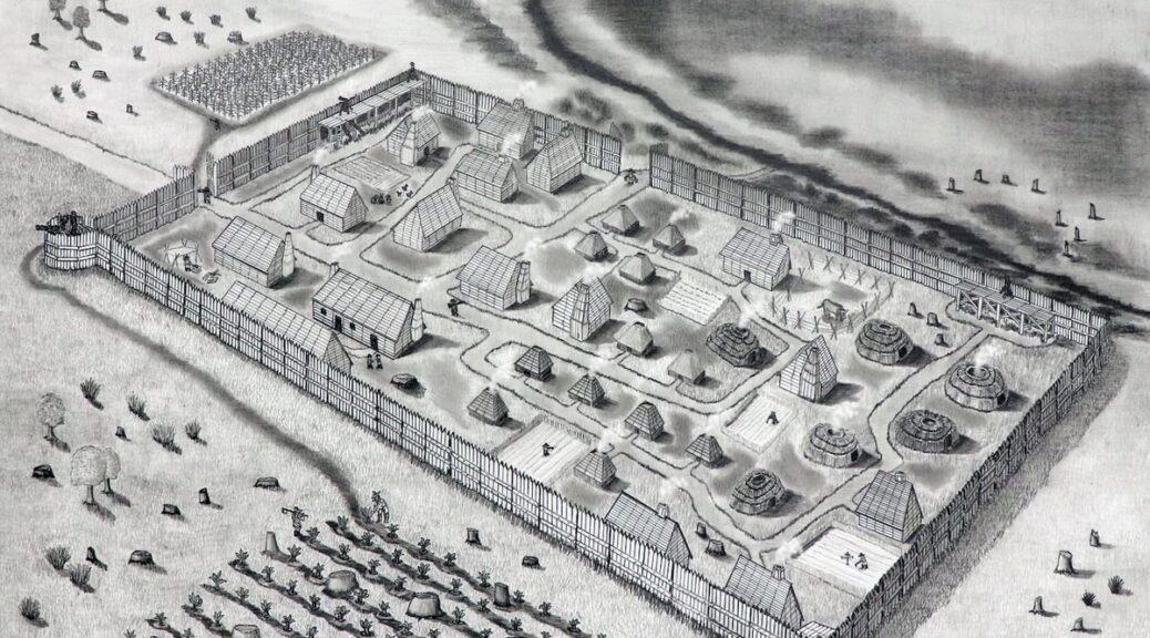
On Monday, Historic St. Mary’s City announced that Parno, director of research for the organization, and Horsley had indeed found the outlines of the palisaded fort that was erected in Southern Maryland by white settlers in 1634. Horsley’s scans had revealed the imprint of post holes that formed a large rectangle with a semicircular bastion at one corner. The scans also showed evidence of what appeared to be dwellings inside the fort, including several that may have been Native American. Excavation later turned up evidence of the brick cellar of a guardhouse or storehouse, the trigger guard for a musket, and a quartzite arrowhead that was 4,500 years old.
Dig on the site of the original fort at St. Mary’s.
Recreation of a 17th century building at Historic St. Mary’s City.
“This is our moment,” Parno said. “This is the earliest colonial archaeological site in Maryland. This is it.”
William M. Kelso, the archaeologist who in 1994 discovered the lost fort at Jamestown, Va., said the discovery is “extremely significant because St. Mary’s is sort of a sister colony … [and] it’s another page to the story, to chapter one.”
Archaeologists had been seeking the St. Mary’s fort since the 1930s. The site today is in an empty meadow where the wind blows off the river and the shadows of soaring turkey buzzards drift over the landscape. It is owned by Historic St. Mary’s City and is about the size of a football field. Much like the famous Jamestown fort, which marked the first permanent English settlement in what would become the United States, its exact location had been lost. The original 150 colonists, including many English Catholics fleeing Protestant persecution back home, had arrived at St. Mary’s on two ships, the Ark and the Dove, in late March 1634, Parno said.
Modern recreation of the Dove.
They were preceded by the English settlers at such places as Jamestown in 1607, Plymouth in 1620, and Massachusetts Bay in 1630. The Maryland group included a Jesuit priest, Father Andrew White; the colony’s first governor, Leonard Calvert; and Mathias de Sousa, an indentured servant of African and Portuguese descent who later served in the legislative assembly of freemen.
“I found a most convenient harbor, and the pleasant country lying on each side of it,” Calvert wrote to his business partner, Richard Lechford, on May 30, 1634.
“On the east side of it we have seated ourselves, within one-half mile of the river,” he wrote. They had erected “a pallizado of one hundred and twenty yards square” with four bastions equipped with small artillery pieces.
The palisade was probably 12- to 14-feet high.
White reported: “Our Towne we call St. Maries … [It] abounds not alone with profit but also with pleasure.”
But like Jamestown, the settlement at St. Mary’s was later abandoned. The capital moved to Annapolis in the 1690s, and the site was left undisturbed and ripe for archaeology. St. Mary’s has produced stunning archaeological finds in the past. It was Maryland’s first capital and home to the first State House. In 1990, experts exhumed three lead-lined coffins containing the remains of Maryland colonial governor Philip Calvert, who died in 1683, his first wife, Anne, and Calvert’s 6-month-old son. Anne’s coffin contained sprigs of the memorial herb rosemary, bits of a silk ribbon that may have been used to bind her wrists for burial — and much of her hair. The baby had suffered from the childhood disease rickets and probably scurvy.
Calvert family coffins discovered in 1990.
The search for the fort had continued through the 1980s and ’90s with inconclusive results. The quest was put on hold for many years as St. Mary’s focused on other projects. Parno resumed the hunt in 2017, and his find was deemed conclusive in late 2019. The plan had been to announce the discovery last year, but the coronavirus pandemic brought that to a halt. Last summer, though, using coronavirus safety protocols, Parno was able to return to the site and uncover the top of what may be the cellar of a building inside the fort.
Parno noted that the site marks not only a turning point in Maryland’s colonial history. It also marked a massive moment of change for the native peoples of this region,” he said.
“Archaeology in this area shows us people have been here for at least 10,000 years. White wrote that the colonists, “to avoid all occasion of dislike, and colour of wrong,” purchased from the local Yaocomaco Indians the land for 30 miles around, paying with axes, hoes, cloth, and hatchets. The Yaocomaco Indians tolerated the newcomers, he wrote, because the Indians had enemies: The “Sasquasahannockes … [who] come sometimes upon them, and waste and spoile them and their country.”
And the archaeology hinted that the fort may have been built around several existing native dwellings, Parno said.
The Yaocomaco people lived on both sides of the St. Mary’s River. The arrangement was that they would be allowed to stay on the east side with the colonists until the Indians’ crops there were harvested. Then they would move to the west side.
“Some few Indians are here to stay by us till next yeare,” Father White wrote. “Then the land is wholy to be ours alone.”
It’s not clear if, for a time, the colonists and the Yaocomaco lived together in the fort, according to the Historic St. Mary’s City website. “But it is likely that their residences were … in relative proximity to one another.” And an Indian dwelling that had been vacated would have provided good shelter for weary colonists.
“You come off this ship after months, and you need a place to lay your head, and you want something that’s covered and warm,” Parno said.
One day this month, tiny pink flags marking the outline of the fort fluttered in the breeze as Parno’s team methodically scraped away soil at the site. After Horsley’s scan found the fort’s outline in 2018, Parno said he verified it with excavation in 2019. He found that there had been a three-foot-deep trench where the colonists had stood the timbers for the palisade. Inside the trench, the wood had left telltale stains in the soil. “It was clear as day,” Parno said.
A conjectural drawing of the 1634 fort at the St. Mary’s settlement in Maryland.
But he had been surprised when the work revealed that the outline of the fort didn’t match Calvert’s 1634 description of it. Instead of the large square palisade with bastions at the four corners that Calvert described, the team found a smaller, rectangular fort with one bastion. The discrepancy may be because Calvert was describing plans for the fort before it was completed, according to Historic St. Mary’s.
As Parno walked the site this month, fellow archaeologist Stephanie Stevens paused with her shovel. She had done archaeology at the site in 2017. “We had always heard about: ‘There’s this fort somewhere, but we don’t know where it is.’ All these different things,” she said.
Then one-day Parno summoned the team, showed the scan of the fort’s outline, and said, “We found it.”
Archaeologist Travis Parno at his dig on the site of the original fort at St. Mary’s.
Giant Face of Ucanha: Huge Sculpted Mayan Mask Found in Mexico
A giant Mayan mask as tall as a person has been revealed at an archaeological site in the Mexican state of Yucatán.
The stucco mask of Ucanha being worked on by archaeologists
The mask, which depicts the face of an unknown deity or elite person, was sculpted from the building material stucco and dates back to a period in Maya history known as the Late Preclassic (about 300 B.C. — A.D. 250), according to the news outlet Novedades Yucatán.
The discovery was made in 2017 at the archaeological site of Ucanha, near the modern-day city of Motul, and since then researchers with Mexico’s National Institute of Anthropology and History (INAH) have worked painstakingly to restore it.
View of the giant stucco face, or Mayan mask, in situ. The face was discovered in the Yucatán Peninsula near the village of Ucanha
Stucco masks like this one “represent the faces of individuals with particular features that can be associated with deities or with characters of prominent social status,” INAH said in a statement.
The mask is a stucco relief, a type of brightly-colored painted sculpture carved from a background of stucco. The Maya typically placed these masks around stairways with pyramidal bases, according to the statement.
Archaeologists have found similar reliefs in Acanceh and Izamal, but this is the first in Ucanha. The discovery is part of ongoing research into Mayan mounds found at the site.
The mask was temporarily reburied after its discovery so that the structure was protected until it could be properly studied and preserved.
Samples taken from the structure revealed deterioration and it was re-excavated in 2018 so that archaeologists could restore it.
During the restoration and conservation process, archaeologists reinforced fragile parts of the mask.
They also moved sections that had been displaced overtime back to their original positions. They also cleaned the surfaces to highlight the mask’s patterns and colors.
The archaeologists completed the work in 2019, before reburying the mask for a final time. INAH said the goal of these efforts is to ensure the long-term preservation of the mask at the site, which does not have legal protection.
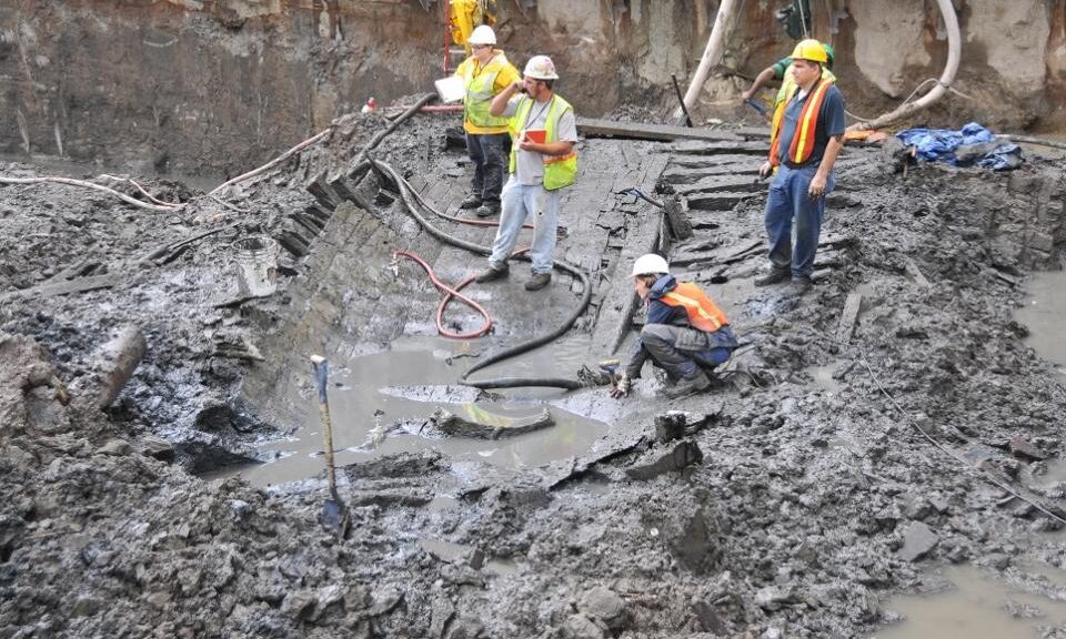
Ship Found 20 Feet Below World Trade Center Site Traced to Colonial-Era Philadelphia
Researchers long stumped by the mysterious history of an 18th-century ship uncovered at the World Trade Center have finally discovered its origins — thanks to tree rings, according to a new study.
The ship was uncovered in 2010, while workers were excavating the World Trade Center site.
The massive wooden ship — the skeleton of which was unexpectedly discovered 25 feet below street level in the muddy excavation of the World Trade Center site in 2010 — has now been traced to Colonial-era Philadelphia, with a history linked to Independence Hall, according to a new report from scientists at Columbia University’s Lamont-Doherty Earth Observatory.
Scientists say the wood from the vessel was chopped in 1773 from a forest of white oak trees in Philadelphia, the same type of trees used to build Independence Hall, where the Constitution and Declaration of Independence were signed.
Columbia scientists were able to link the growth rings found in the old wood of the ship with a previously taken sample of wood from Independence Hall, researchers said.
Tree rings are like “barcodes” that create unique patterns, allowing for dating, said Neil Pederson, Columbia tree ring scientist and co-author of the study.
Archaeologists dismantle the remains of an 18th-century ship at the World Trade Center construction site.
While the majority of the boat was made from white oak, a sample from the keel of the ship was the key to narrowing down its history.
“The keel was actually made from hickory, which was only found in the Eastern United States or Eastern Asia, which meant we could really narrow down our search — East Asia wasn’t really a possibility,” Pederson said. “That discovery really put me in a good mood — and put us in a good geographic zone.”
The ship’s 32-foot hull was carefully dug out of the muck in July 2010, exhaustively documented, disassembled, and sent off for preservation at the Maryland Archaeological Conservation Laboratory. Some timber samples, however, were sent to Columbia for analysis.
Historians believe the vessel was likely a merchant ship, in the Dutch style of a Hudson River sloop. It likely traveled along the Atlantic, bringing wood and food down to the West Indies and returning with sugar, salt, molasses, and rum.
The ship suffered an infestation of Teredo worms while in the Caribbean, which likely ate away at its wood and led to its demise after about 20 to 30 years on the water. It’s believed that by 1797, the boat was buried in the landfill used to extend Manhattan’s shoreline westward.
Hundreds of artifacts were found in and around the boat, including ceramics, musket balls, a buckle, a British button, a coin, animal bones, dozens of shoes, and a human hair with a single louse on it.
The ship remains at the Maryland Archaeological Conservation Laboratory, and researchers say it’s possible it may eventually be reassembled.
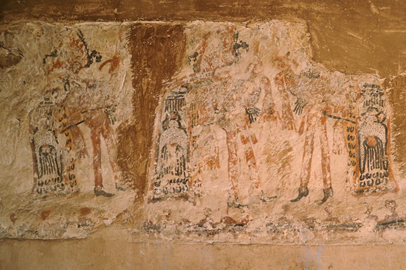
Guatemalan family uncovers ancient Mayan murals on their kitchen walls during a home renovation
Home renovations in a Guatemalan mountain village in 2003 unearthed “unparalleled” Maya murals, according to researchers. Now, reports broadcast network RT, a new analysis published in the journal Antiquity has revealed additional insights on the wall paintings, which date to the 17th or 18th century and blend Spanish colonial influences with local indigenous culture.
Lucas Asicona Ramirez, right, discovered the centuries-old paintings after he started chipping away at the plaster in the kitchen of his house.
Local historian and study co-author Lucas Asicona Ramírez found the murals while renovating his kitchen in Chajul, a rural town in Guatemala’s highlands, reported Mike McDonald for Reuters in 2012.
Several houses in Chajul, including Asicona’s, date to the colonial era (1524 to 1821); other locals have discovered similarly historic artworks behind the plaster in their homes.
The Ramirez home is located in the impoverished town of Chajul, Guatemala.
Researchers work to preserve the Maya wall paintings inside the Chajul home.
The majority of Guatemala’s colonial-era murals are found in houses of worship. Centered on Christian themes, these religious artworks were used by the Spanish to assert their dominance over the Maya people, writes Tom Fish for Express. In contrast, the Chajul wall paintings appear inside private homes—and, most tellingly, contain distinct flourishes of indigenous culture.
“We consider these murals to be very unique,” Ivonne Putzeys, an archaeologist at the University of Guatemala in San Carlos, told Reuters. “It’s a tangible heritage that represents [s] real scenes from history.”
In 2015, an international team of researchers started preserving and studying the murals in collaboration with a Maya community indigenous to Guatemala: the Ixil. This group formed the bulk of the roughly 200,000 people killed during the Guatemalan Civil War, which lasted from 1960 to 1996.
As the experts write in the paper, conducting interviews and consultations with the Ixil was essential to understanding the art’s cultural context.
Many of the friezes feature dancers and musicians. Jaroslaw Źrałka, an archaeologist at Jagiellonian University and first author of the new study, tells Ancient Origins’ Ed Whelan that dance played an important role in the Maya civilization, both recording and relaying history and cultural practices. The dance was so important to the Maya that Spanish missionaries used it as a conversion tool, says Źrałka.
Through interviews with the Chajul Ixil community, the researchers were able to identify specific murals as depictions of known dances from the colonial era.
A mural of ancient vessels adorns the wall next to the family’s stove.
One mural shows tall, bearded conquistadors playing drums as they encounter a dancer dressed in a traditional feathered costume. This scene may illustrate the Dance of the Conquest, which details Spain’s invasion and attempts to convert the Maya to Christianity.
Another mural may show the Dance of the Moors and the Christians. Introduced by the Spaniards, this performance tells the story of Spain’s seizure of lands occupied by Muslim kingdoms, according to Express.
The researchers note that the wall art may also feature dances now lost to history. Many were forgotten when the government prohibited the performance of indigenous dances in the 19th and 20th centuries.
Chemical analysis of the paintings revealed the use of natural clay pigments typical in Maya art, suggesting the murals were indeed created by indigenous artists, reports Ancient Origins. The artworks’ style hews closely to local traditions, showing few signs of foreign influences.
The researchers suggest that the houses in which the murals were found once belonged to key community members—perhaps members of what was known as the cofradías, or brotherhood.
These groups organized religious events connected to both Christian and pre-Hispanic Maya traditions. The houses featuring the friezes may have served as meeting places or venues for rituals and dances.
Per the paper, the murals’ blending of Maya and European imagery could mean that local culture, as revived by the cofradías, was making a defiant comeback as Spain’s influence and control over the region faded.
The Arctic Could Turn Green and Free of Ice Like it was 125,000 Years Ago
Researchers analyzed plant DNA more than 100,000 years old retrieved from lake sediment in the Arctic (the oldest DNA in lake sediment analyzed in a publication to date) and found evidence of a shrub native to northern Canadian ecosystems 250 miles (400 km) farther north than its current range.
As the Arctic warms much faster than everywhere else on the planet in response to climate change, the findings, published this week in the Proceedings of the National Academy of Sciences, may not only be a glimpse of the past but a snapshot of our potential future.
“We have this really rare view into a particularly warm period in the past that was arguably the most recent time that it was warmer than present in the Arctic. That makes it a really useful analogue for what we might expect in the future,” said Sarah Crump, who conducted the work as a Ph.D. student in geological sciences and then a postdoctoral researcher with the Institute of Arctic and Alpine Research (INSTAAR).
To gain this glimpse back in time, the researchers not only analyzed DNA samples, they first had to journey to a remote region of the Arctic by ATV and snowmobile to gather them and bring them back.
Dwarf birch is a key species of the low Arctic tundra, where slightly taller shrubs (reaching a person’s knees) can grow in an otherwise cold and inhospitable environment. But dwarf birch doesn’t currently survive past the southern part of Baffin Island in the Canadian Arctic. Yet researchers found DNA of this plant in the ancient lake sediment showing it used to grow much farther north.
“It’s a pretty significant difference from the distribution of tundra plants today,” said Crump, currently a postdoctoral fellow in the Paleogenomics Lab at the University of California Santa Cruz.
Tundra Plants
While there are many potential ecological effects of the dwarf birch creeping farther north, Crump and her colleagues examined the climate feedbacks related to these shrubs covering more of the Arctic. Many climate models don’t include these kinds of changes in vegetation, yet these taller shrubs can stick out above snow in the spring and fall, making the Earth’s surface dark green instead of white — causing it to absorb more heat from the sun.
“It’s a temperature feedback similar to sea ice loss,” said Crump. During the last interglacial period, between 116,000 and 125,000 years ago, these plants had thousands of years to adjust and move in response to warmer temperatures. With today’s rapid rate of warming, the vegetation is likely not keeping pace, but that doesn’t mean it won’t play an important role in impacting everything from thawing permafrost to melting glaciers and sea-level rise.
“As we think about how landscapes will equilibrate to current warming, it’s really important that we account for how these plant ranges are going to change,” said Crump.
As the Arctic could easily see an increase of 9 degrees Fahrenheit (5 degrees Celsius) above pre-industrial levels by 2100, the same temperature it was in the last interglacial period, these findings can help us better understand how our landscapes might change as the Arctic is on track to again reach these ancient temperatures by the end of the century.
Mud as a microscope
To get the ancient DNA they wanted, the researchers couldn’t look to the ocean or to the land — they had to look in a lake. Baffin Island is located on the northeastern side of Arctic Canada, kitty-corner to Greenland, in the territory of Nunavut and the lands of the Qikiqtaani Inuit. It’s the largest island in Canada and the fifth-largest island in the world, with a mountain range that runs along its northeastern edge. But these scientists were interested in a small lake, past the mountains and near the coast.
Above the Arctic Circle, the area around this lake is typical of a high Arctic tundra, with average annual temperatures below 15 °F (?9.5 °C). In this inhospitable climate, the soil is thin and not much of anything grows.
But DNA stored in the lake beds below tells a much different story. To reach this valuable resource, Crump and her fellow researchers carefully balanced on cheap inflatable boats in the summer — the only vessels light enough to carry with them — and watched out for polar bears from the lake ice in winter. They pierced the thick mud up to 30 feet (10 meters) below its surface with long, cylindrical pipes, hammering them deep into the sediment.
The goal of this precarious feat? To carefully withdraw a vertical history of ancient plant material to then travel back out with and take back to the lab. While some of the mud was analyzed at a state-of-the-art organic geochemistry lab in the Sustainability, Energy and Environment Community (SEEC) at CU Boulder, it also needed to reach a special lab dedicated to decoding ancient DNA, at Curtin University in Perth.
To share their secrets, these mud cores had to travel halfway across the world from the Arctic to Australia.
A local snapshot
Once in the lab, the scientists had to suit up like astronauts and examine the mud in an ultra-clean space to ensure that their own DNA didn’t contaminate that any of their hard-earned samples.
It was a race against the clock.
“Your best shot is getting fresh mud,” said Crump. “Once it’s out of the lake, the DNA is going to start to degrade.”
This is why older lake bed samples in cold storage don’t quite do the trick. While other researchers have also collected and analyzed much older DNA samples from permafrost in the Arctic (which acts as a natural freezer underground), lake sediments are kept cool, but not frozen. With fresher mud and more intact DNA, scientists can get a clearer and more detailed picture of the vegetation which once grew in that immediate area.
Reconstructing historic vegetation has most commonly been done using fossil pollen records, which preserve well in sediment. But pollen is prone to only showing the big picture, as it is easily blown about by the wind and doesn’t stay in one place. The new technique used by Crump and her colleagues allowed them to extract plant DNA directly from the sediment, sequence the DNA, and infer what plant species were living there at the time. Instead of a regional picture, sedimentary DNA analysis gives researchers a local snapshot of the plant species living there at the time. Now that they have shown it’s possible to extract DNA that’s over 100,000 years old, future possibilities abound.
“This tool is going to be really useful on these longer timescales,” said Crump. This research has also planted the seed to study more than just plants. In the DNA samples from their lake sediment, there are signals from a whole range of organisms that lived in and around the lake.
“We’re just starting to scratch the surface of what we’re able to see in these past ecosystems,” said Crump. “We can see the past presence of everything from microbes to mammals, and we can start to get much broader pictures of how past ecosystems looked and how they functioned.”