Category Archives: NORTH AMERICA

Miners Unearth 50,000-Year-Old Caribou Calf, Wolf Pup From Canadian Permafrost

Miners Unearth 50,000-Year-Old Caribou Calf, Wolf Pup From Canadian Permafrost

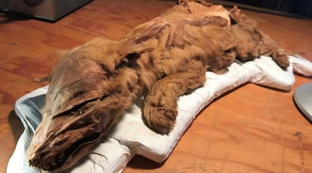
A mummified wolf pup and caribou believed to have walked Earth over 50,000 years ago were discovered with tissue and fur intact — a remarkable find, Canadian authorities say.

The caribou was found at the site of an 80,000-year-old volcanic ash bed and officials believe it’s among the oldest mummified mammal tissue in the world, according to a release.

It was discovered by gold miners, the wolf pub was remarkably well-preserved remains of a caribou calf and wolf pup that each lived more than 50,000 years ago.

The Ice Age specimens were found in the Tr’ondëk Hwëch’in Traditional Territory, a First Nation territory in Yukon.

Officials say the ancient caribou dug up from a site containing an 80,000-year-old volcanic ash bed now stands as one of the oldest examples of mummified mammal tissue in the world.

Gold miners in Canada have discovered the remarkably well-preserved remains of a caribou calf and wolf pup (shown) that each lived more than 50,000 years ago. The wolf pup’s remains were complete, with its head, tail, paws, skin, and hair

After miners first discovered the mummified animals in the Klondike region, researchers with the Yukon Paleontology Program recovered and conducted analyses of the remains.

With each still containing hair, skin, and muscle tissue, the experts say the discoveries are extremely rare.

The 50,000-year-old caribou and wolf pup could help to ‘shed light on Yukon’s fascinating Ice Age history and will help us understand how these long-gone creatures lived in the environment they inhabited,’ said Premier Sandy Silver.

Both of the mummies were discovered back in 2016.

The caribou calf was found on Tony Beets’ placer gold mine on Paradise Hill June 3 of that year. Beets are best known from Discovery’s show, Gold Rush.

The mummified wolf pup was found the following month.

Officials say the ancient caribou dug up from a site containing an 80,000-year-old volcanic ash bed now stands as one of the oldest examples of mummified mammal tissue in the world. Only the front half of its body remained intact

While the caribou carcass is missing some parts of its body, with only the front half still intact, the wolf pup was found to be complete, with its head, tail, paws, skin, and hair.

‘We found the caribou and our neighbours, the Favron’s found the wolf pup,’ Beets wrote on Facebook.

‘Such amazing things to be found here under the midnight sun.’

The discoveries hold special significance to the Tr’ondëk Hwëch’in, upon whose land they were discovered. Both animals will be on display for the rest of the month, before being moved to the Yukon Beringia Interpretive Centre in Whitehorse. The mummified wolf is shown

The two Ice Age specimens were unveiled at the Dänojà Zho Cultural Centre last week.

And, they hold special significance to the Tr’ondëk Hwëch’in, upon whose land they were discovered.

‘For Tr’ondëk Hwëch’in, wolf and caribou are very important and interconnected,’ said Tr’ondëk Hwëch’in Chief Roberta Joseph.

‘The caribou has fed and clothed our people for thousands of years. The wolf maintains balance within the natural world, keeping the caribou healthy.’

Both mummified animals will be on display for the rest of the month, before being incorporated into an exhibit at the Yukon Beringia Interpretive Centre in Whitehorse.

‘These specimens will help scientists learn more about the ancient mammal species that roamed Beringia, increasing our knowledge and ability to share the stories of this lost, ancient land,’ said Minister of Tourism and Culture Jeanie Dendys.

19th-century wagon discovered at Detroit Lake when it was at its lowest level in 46 years

19th-century wagon discovered at Detroit Lake when it was at its lowest level in 46 years

The unprecedented drought on the west coast of the United States that has lasted for over four years now has had a major impact on everything from water supplies to agriculture to fisheries.

Preserved beneath the reservoir’s waves in a low-oxygen environment, the wagon was probably more damaged during its short public appearance than it was underwater for decades.

But in one town in Oregon, the resulting historic low water levels have dredged up history: the remains of a town that was abandoned and sunk beneath a reservoir more than 60 years ago.

Back in 1953, the 200 residents of the tiny town of Old Detroit deserted their homes after Congress approved a nearby dam, which, when finished, would flood the area to create the reservoir now known as the Detroit Lake.

Ever since, when the lake’s water level fell, remnants of the town would sometimes rise out of the water. With the lake’s water level at a record low this year, when a local sheriff’s deputy drove past the lake in late October to take a look, he discovered the perfectly preserved remains of a 19th-century wagon, half-sunk in the mud.

“I went on a treasure hunt down along the river, figuring I’d find foundations or something like that,” Marion County Sheriff’s Deputy Dave Zahn tells Christena Brooks for the Statesman Journal. “Then I saw a piece of old history right there.”

The lack of snowfall last winter caused Detroit Lake’s water levels to drop to the lowest they’ve been in almost 50 years, approximately 143 feet below capacity. 

When Zahn decided to poke around in the newly dry lake bed, he discovered the utility wagon alongside an octagonal pit lined with cement that experts still haven’t identified, Brooks reports.

“As far as I know, the wagon’s never been seen until this year,” U.S. Forest Service archaeologist Cara Kelly tells Brooks. “This might not have been its original resting place…It could’ve come from anywhere in the town of Detroit or even up the drainage.”

While Zahn first spotted the wagon on October 29, he and Kelly decided to keep its location a secret, so as not to attract potential looters and vandals.

According to a metal plate attached to the wagon as seen in some of Zahn’s photographs, the wagon was made in 1875 by the Milburn Wagon Company of Toledo, Ohio, which was one of the country’s largest manufacturers of wagons at the time.

As Brooks reports, the lake bottom’s low oxygen levels almost perfectly preserved the wagon – ironically, its brief stint on land probably damaged it more than all the decades it spent underwater.

Old Detroit isn’t the only town briefly revealed by a historic drought: that same month, a drought in the Mexican state of Chiapas uncovered the ruins of a 450-year-old church.

The “Temple of Quechula,” as it is known, was originally built by Dominican monks near a conquistador highway, but was abandoned in the 18th century after a series of plagues struck the region.

This year, lake levels dropped so low that locals were able to take tourists out to see the ruins.

Even though Oregon’s drought may have uncovered a reminder of Detroit’s history, this year’s dry weather had such a bad effect on the town that Zahn hopes his once-in-a-lifetime experience stays that way.

“Hopefully it will be another 40 years before Detroit’s this low again,” Zahn tells Brooks.

Long lost palace and death site of Moctezuma II discovered in Mexico

Long lost palace and death site of Moctezuma II discovered in Mexico

The remains of an Aztec palace where emperor Moctezuma II was held captive by the Spanish and killed in 1520 has been discovered in Mexico City. 

Archaeologists found the remains of a basalt slab floor from the Aztec palace.

Historical records say that the Spanish conquistador Hernan Cortes took Moctezuma II (also known as Moctezuma Xocoyotzin, sometimes also spelled Montezuma) hostage and held him in the palace in an attempt to force the emperor to control the Aztec population.

The people quickly rebelled and laid siege to the Spaniards in the palace. The Spanish tried to quell the rebellion by having Moctezuma II address the rebels from a palace balcony, but the rebels refused to stop their siege and the emperor was killed in the crossfire. 

The Spanish conquistadors eventually destroyed the rebel forces along with the Aztec city of Tenochtitlan (where modern-day Mexico City is located).

The surviving Aztec people were forced to build a new city over the ruins of Tenochtitlan.

A house for Cortes, which was also discovered by archaeologists during the excavation, was built over the remains of the palace. 

Sculptures from the Aztec palace were reused to build the house of conquistador Hernan Cortes.
This palace was built from the remains of the destroyed Aztec palace.

Reusing sculptures

They found the palace remains — which include basalt slab floors that may have been part of a plaza — beneath an 18th-century pawn shop. The archaeologists also found that sculptures from the palace were reused like blocks to build Hernan Cortes’ house. 

One sculpture depicts “a feathered serpent” that appears to show Quetzalcóatl, a god that had been widely worshipped across Mesoamerica for millennia prior to the Spanish conquest, archaeologists from Mexico’s National Institute of Anthropology and History said in a statement.

Another sculpture that depicts “a headdress of feathers” also appears to be from the palace and was also reused to build Cortes house, the archaeologists found. 

The discovery of the palace and Cortes’ house “revives the memory of those historical events, five centuries later” the archaeologists said in the statement. 

They made the discoveries during excavation work conducted beneath the National Monte de Piedad, a pawnshop founded in 1775 that aimed to make it easier for the poor to borrow money. 

The excavation work was carried out prior to renovation work being done on the building. Today, the Nacional Monte de Piedad is a nonprofit foundation that performs a wide range of charitable work throughout Mexico. 

Cahokia: The largest and most complex ancient archaeological site you probably didn’t hear of

Cahokia: The largest and most complex ancient archaeological site you probably didn’t hear of

I’m standing at the center of what was once the greatest civilization between the deserts of Mexico and the North American Arctic—America’s first city and arguably American Indians’ finest achievement—and I just can’t get past the four-lane gash that cuts through this historic site.

Instead of imagining the thousands of people who once teemed on the grand plaza here, I keep returning to the fact that Cahokia Mounds in Illinois is one of only eight cultural World Heritage sites in the United States, and it’s got a billboard for Joe’s Carpet King smack in the middle of it.

But I suppose Cahokia is lucky. Less than ten miles to the west, the ancient Indian mounds that gave St. Louis the nickname Mound City in the 1800s were almost completely leveled by the turn of the century.

Today only one survives, along with some photographs and a little dogleg road named Mound Street.

The relentless development of the 20th century took its own toll on Cahokia: Horseradish farmers razed its second-biggest mound for fill-in 1931, and the site has variously been home to a gambling hall, a housing subdivision, an airfield, and (adding insult to injury) a pornographic drive-in.

But most of its central features survived, and nearly all of those survivors are now protected.

Cahokia Mounds may not be aesthetically pristine, but at 4,000 acres (2,200 of which are preserved as a state historic site), it is the largest archaeological site in the United States, and it has changed our picture of what Indian life was like on this continent before Europeans arrived.

Cahokia was the apogee, and perhaps the origin, of what anthropologists call Mississippian culture—a collection of agricultural communities that reached across the American Midwest and Southeast starting before A.D. 1000 and peaking around the 13th century.

The idea that American Indians could have built something resembling a city was so foreign to European settlers, that when they encountered the mounds of Cahokia—the largest of which is a ten-story earthen colossus composed of more than 22 million cubic feet of soil—they commonly thought they must have been the work of a foreign civilization: Phoenicians or Vikings or perhaps a lost tribe of Israel.

Even now, the idea of an Indian city runs so contrary to American notions of Indian life that we can’t seem to absorb it, and perhaps it’s this cognitive dissonance that has led us to collectively ignore Cahokia’s very existence. Have you ever heard of Cahokia? In casual conversation, I’ve found almost no one outside the St. Louis area who has.

Researchers believe that Cahokia was home to around fifteen thousand people although they estimate that the regional population was home to around forty-thousand people; researchers even believe that Cahokia could have been the world’s biggest metropolis of its time.

The center of the ancient city was the Monk’s mound, the home of the city’s ruling priest was located at the top of the mound in a temple that was made of wood.

A ten-story behemoth known as Monks Mound is the centerpiece of the 2,200 acre Cahokia Mounds State Historic Site. Eighty surviving mounds dot this cultural World Heritage site; some were used as building platforms, some for burials.

The social structure of ancient Cahokia was very similar to the rule of ancient Mayan society and/or the ancient Egyptian culture; a graded aristocracy and a proletariat of slaves.

The decline of Cahokia was very sudden, by 1300 the city was abandoned and the society declined completely; like many ancient cultures such as the Maya in the Yucatan region, archaeologists believe that the prevailing factors that contributed to the fall of Cahokia were overexploitation of their natural resources, the construction of the great mound, droughts and overpopulation.

Very similar to the factors that caused the demise of the great Maya civilization.

Massive 1,100 Year Old Maya Site Discovered In Georgia’s Mountains?

Massive 1,100 Year Old Maya Site Discovered In Georgia’s Mountains?

The Mayans built astonishing temples in Mexico, Guatemala, and Honduras – but now some believe the ancient peoples fled their dissolving civilization and ended up in Georgia.

Historian and architect Richard Thornton believes a 1,100-year-old archaeological site shows that Mayan refugees fled Central America and ended up in the North Georgian mountains near Blairsville.

His astonishing theory is based on the discovery of 300 to 500 rock terraces and mounds on the side of Brasstown Bald mountain that date to 900AD – around the time the Mayans began to die out.

Massive 1,100 Year Old Maya Site Discovered In Georgia's Mountains?
City Spotting: This 3D virtual reality image was made from the ruins found in the Brasstown Bald mountain

Mr. Thornton’s blockbuster theory revolves around the area near Brasstown Bald potentially being the ‘fabled city of Yupaha, which Spanish explorer Hernando de Soto failed to find in 1540’.

He described it as ‘certainly one of the most important archaeological discoveries in recent times’.

The Mayans died out around 900AD for reasons still debated by scholars – although drought, overpopulation, and war are the most popular theories, reported the Atlanta Journal-Constitution.

The remains were first found by retired engineer Carey Waldrip when he went walking in the area in the 1990s. Archaeologist Johannes Loubser excavated part of the site and wrote a report about it in 2010, but does not believe the rock terraces are Mayan.

‘I think that (Mr. Thornton) selectively presents the evidence,’ Mr. Loubser told the Atlanta Journal-Constitution. ‘But he’s a better marketer than I and other archaeologists are.’

Look at this: The remains were first found by retired engineer Carey Waldrip, pictured, when he went walking in the area in the 1990s

Mr. Loubser, who excavated a rock wall and small mound, added that claims like this must be backed up with ‘hard evidence’ because of the various conflicting opinions in the archaeological world.’

Mr. Loubser believes the structures could have been built by the Cherokee Indians or an earlier tribe between 800AD and 1100AD.

He stopped digging because he realized the site could be a grave. Still, Mr. Thornton claims early maps of the location named two villages ‘Itsate’, which was how Itza Mayans described themselves.

The terrace structures and date helped him reach his conclusion. It was commonplace for the Itza Maya to sculpt a hill into a pentagonal mound,’ he argues. ‘There are dozens of such structures in Central America.’

But not everyone is impressed by Mr. Thornton’s theory. He cited the University of Georgia archaeology professor Mark Williams in an article on Examiner.com.

‘I am the archaeologist Mark Williams mentioned in this article,’ Professor Williams said on Facebook. ‘This is total and complete bunk. There is no evidence of Maya in Georgia. Move along now.’

Theory: The Mayans could have left Central America and ended up in the North Georgian mountains
Fascinating: The Mayans died out around 900AD for reasons still debated by scholars – although drought, overpopulation and war are the most popular theories (file picture)

‘The sites are certainly those of Native Americans of prehistoric Georgia,’ Professor Williams told ABC News. ‘Wild theories are not new, but the web simply spreads them faster than ever.’

Mr. Thornton wasn’t bothered by the ensuing debate, in fact, that’s exactly what he wanted.

‘I’m not an archaeologist. I’m a big picture man,’ said Mr. Thorton to the Atlanta Journal-Constitution.

‘We’re hoping this article stirs up some interest. I was just trying to get the archaeologists to work some more on the site and they come back snapping like mad dogs.’

He works with a company called History Revealed Media that helps create three-dimensional maps of excavated sites and said that when he compared his map of the Georgia site, it reminded him of other Mayan works.

‘It’s identical to sites in Belize,’ he argued.

The Mayans have been under intense scrutiny over the past few years as rumors abound about their mysterious 5,132-year calendar allegedly predicting the apocalypse on December 21, 2019.

But various experts have spoken out against Doomsday, including Mexico’s ‘Grand Warlock’ Antonio Vazquez, to say that the Mayan calendar instead will just reset and a new time-span will begin.

A Lost Japanese Village Has Been Uncovered in the British Columbia Wilderness

A Lost Japanese Village Has Been Uncovered in the British Columbia Wilderness

In 2004, archaeology professor Robert Muckle was alerted to a site within the forests of British Columbia’s North Shore mountains, where a few old cans and a sawblade had been discovered. He suspected the area was once home to a historic logging camp, but he did not anticipate that he would spend the next 14 years unearthing sign after sign of a forgotten Japanese settlement—one that appears to have been abruptly abandoned.

Brent Richter of the North Shore News reports that Muckle, an instructor at Capilano University in Vancouver, and his rotating teams of archaeology students have since excavated more than 1,000 items from the site.

The artifacts include rice bowls, sake bottles, teapots, pocket watches, buttons, and hundreds of fragments of Japanese ceramics. Muckle tells Smithsonian that the “locations of 14 small houses … a garden, a wood-lined water reservoir, and what may have been a shrine,” were also discovered, along with the remnants of a bathhouse—an important fixture of Japanese culture.

Dishes and bottles found at the site in the Lower Seymour Conservation Reserve.

The settlement sits within an area now known as the Lower Seymour Conservation Reserve, located around 12 miles northeast of Vancouver.

Muckle has in fact uncovered two other sites within the region that can be linked to Japanese inhabitants: one appears to have been part of a “multi-ethnic” logging camp, Muckle says, the second a distinctly Japanese logging camp that was occupied for several years around 1920. But it is the third site, which seems to have transitioned from a logging camp to a thriving village, that fascinates him the most.

“There was very likely a small community of Japanese who were living here on the margins of an urban area,” Muckle tells Richter. “I think they were living here kind of in secret.”

In approximately 1918, a Japanese businessman named Eikichi Kagetsu secured logging rights to a patch of land next to where the village once stood, making it likely that the site was once inhabited by a logging community.

The trees would have been largely harvested by around 1924, but Muckle thinks the village’s residents continued to live there past that date.

“The impression that I get, generally speaking, is it would have been a nice life for these people, especially in the context of all the racism in Vancouver in the 1920s and ’30s,” he tells Richter.

The first major wave of Japanese immigration to Canada began in 1877, with many of the new arrivals settling in the coastal province of British Columbia. From the start, they were met with hostility and discrimination; politicians in the province prohibited Asian residents from voting, entering the civil service, and working in various other professions, like law, according to the Canadian Encyclopedia.

Anti-Japanese prejudices boiled over during the Second World War, in the wake of the attack on Pearl Harbor in December 1941. Days later, Japanese troops invaded Hong Kong, killing and wounding hundreds of Canadian soldiers who were stationed there.

Back in Canada, authorities began arresting suspected Japanese operatives, impounding Japanese-owned fishing boats, and shutting down Japanese newspapers and schools. By the winter of 1942, a 100-mile strip of the Pacific Coast had been designated a “protected area,” and people of Japanese descent were told to pack a single suitcase and leave.

Families were separated—men sent to work on road gangs, women, and children to isolated ghost towns in the wilderness of British Columbia. According to the Canadian Encyclopedia, more than 90 percent of Japanese Canadians were uprooted during the war, most of the citizens by birth.

No records survive of the people who lived in the North Shore camp, and Muckle has yet to find an artifact that can be reliably dated to after 1920. But given that the inhabitants of the village seem to have departed in a hurry, leaving precious belongings behind, he tells Smithsonian that he suspects they stayed in their little enclave in the woods until 1942, when “they were incarcerated or sent to road camps.”

Eventually, per the CBC, the Greater Vancouver Water District closed off the valley where the settlement was located, and the forest began to take over.

Speaking to Richter of North Shore News, Muckle notes that, after nearly 15 years spent excavating at the site, he will likely not return again.

But he hopes to share his records and artifacts with several museums and archives— including the Nikkei National Museum & Cultural Centre in Burnaby, British Columbia, which seeks to preserve Japanese Canadian history and heritage—so the forgotten settlement in the woods will be remembered for years to come.

This 2,400-year-old mushroom is the largest living organism on the planet

This 2,400-year-old mushroom is the largest living organism on the planet

The largest living thing on the planet is not a whale or any other animal you might expect. It is a giant fungus that kills anything in its path, currently taking up more than three square miles of Oregon.

The Armillaria ostoyae, more popularly known as the honey mushroom, began from a single spore too tiny to be seen by the naked eye. It has been entwining its black shoestring filaments over the forest for an estimated 2,400 years, which causes trees to die as it grows.

Spreading through the roots of trees, this fungus covers 2,200 acres today, which makes it the largest living organism ever to be found.

“When you’re on the ground, you don’t notice the pattern, you just see dead trees in clusters,” said Tina Dreisbach, a botanist, and mycologist working with the U.S. Forest Service’s Pacific Northwest Research Station in Corvallis, Oregon.

Extremely similar to a mushroom, the outline of this giant fungus extends 3.5 miles across, and fairly stretches three feet into the ground, covering an area as large as 1,665 football fields. No one has yet estimated its weight.

Dead Trees Reveal Fungus

In 1998, Catherine Parks, a scientist at the Pacific Northwest Research Station in La Grande, Ore., discovered this. She heard about a large tree die-off from root decay in the forest east of Prairie City, Ore.

With aerial shots, Parks checked out an area of dying trees and gathered root samples among 112 of them.

She singled out the fungus through DNA testing. Then, through comparing cultures of the fungus developed from the 112 samples, she was able to determine that 61 of them were from the same organism, which means that a single fungus had grown bigger than anyone had ever illustrated before.

Dry Climate May Encourage Growth

As it is microscopic, the only evidence of the fungus on the surface are clumps of golden mushrooms that materialize in the fall with the rain.

“They are edible, but they don’t taste the best,” said Dreisbach. “I would put lots of butter and garlic on them.”

Unearthing the roots of one affected tree, something that matches white latex paint can be observed. These are actually mats of mycelium, which sip water and carbohydrates from the tree as fungus grub, thus interfering with the tree’s absorption of nutrients.

Rhizomorphs are the black shoestring filaments that stretch as long as 10 feet into the soil, infesting tree roots through a mixture of pressure and enzyme action.

Scientists are absorbed in learning to control Armillaria as it kills trees, however, they soon realize that the fungus has served a purpose in nature for millions of years.

30,000-year-old stone tools discovered in Mexican Cave suggest humans reached America much earlier than thought

30,000-year-old stone tools discovered in Mexican Cave suggest humans reached America much earlier than thought

Stone tools unearthed in a cave in Mexico indicate that humans could have lived in the area as early as about 33,000 years ago, researchers report online July 22 in Nature. That’s more than 10,000 years before humans are generally thought to have settled North America.

This controversial discovery enters a new piece of evidence into the fierce debate about when and how the Americas were first populated. The initial peopling of the Americas is a contested and evolving topic, with the exact timing of the first arrivals still unknown.

Historically, Mexico’s understudied and controversial archaeological record has remained on the periphery of First Americans’ research.

Evidence of human presence at Chiquihuite Cave extends this antiquity and attests to the cultural variability of older-than-Clovis sites and the earliest humans on the continent.

“For decades people have passionately debated when the first humans entered the Americas,” said Professor Eske Willerslev, a researcher at St John’s College at the University of Cambridge and director of the Lundbeck Foundation GeoGenetics Centre at the University of Copenhagen.

“Chiquihuite Cave will create a lot more debate as it is the first site that dates the arrival of people to the continent to around 30,000 years ago — 15,000 years earlier than previously thought.”

“These early visitors didn’t occupy the cave continuously, we think people spent part of the year there using it as a winter or summer shelter, or as a base to hunt during migration.”

“We don’t know who they were, where they came from, or where they went. They are a complete enigma,” added Dr. Ciprian Ardelean, an archaeologist at the University of Zacatecas.

“We falsely assume that the indigenous populations in the Americas today are direct descendants from the earliest Americans, but now we do not think that is the case.”

“By the time the famous Clovis population entered America, the very early Americans had disappeared thousands of years before. There could have been many failed colonization that was lost in time and did not leave genetic traces in the population today.”

Professor Willerslev, Dr. Ardelean, and their colleagues excavated a total of 1,930 stone tools such as knives, scrapers, and arrowheads in Chiquihuite Cave.

Archaeologists have unearthed what appears to be stone tools, including this one, in a cave in central Mexico that date to as early as about 33,000 years ago.

“The collection of artifacts reveals advanced flaking skills applied to challenge raw material, represented by green and blackish varieties of recrystallized limestone,” the scientists said.

“The flaked tools reflect a previously unknown and mostly unchanged technological tradition.”

Examples of stone artifacts from Chiquihuite Cave: (a) core, (b-e) flakes; inlay in b emphasizes an isolated platform, (f-j) blades, (k-o) points

The authors also attempted to identify ancient human DNA in all archaeological layers of the cave.

However, no evidence of human DNA within the samples was found. This adds weight to the theory that the early people didn’t stay for long in the cave.

“We identified DNA from a wide range of animals including black bears, rodents, bats, voles, and even kangaroo rats,” said Dr. Mikkel Winther Pedersen, a geneticist at the University of Copenhagen.

“We think these early people would probably have come back for a few months a year to exploit reoccurring natural resources available to them and then move on. Probably when herds of large mammals would have been in the area and who had little experience with humans so they would have been easy prey.”

“The location of Chiquihuite Cave definitely rewrites what has conventionally been taught in history and archaeology and shows that we need to rethink where we look for sites of the earliest people in the Americas.”