Scientists have unearthed an Inca-era tomb under a home in the heart of Peru’s capital, Lima, a burial believed to hold remains wrapped in cloth alongside ceramics and fine ornaments.
500-year old structure, found in working-class area of Lima, thought to contain remains of society elites
The lead archaeologist, Julio Abanto, told Reuters the 500-year-old tomb contained “multiple funerary bundles” tightly wrapped in cloth.
He said those entombed were probably from the elite of Ruricancho society, a culture that once populated present-day Lima before the powerful Inca came to rule a sprawling empire across the length of western South America in the 1400s.
Hipolito Tica, the owner of the house in Lima, said he was overcome with emotion at the surprise find. “It’s amazing. I really have no other words to describe it,” he said, expressing a hope that future generations in the working-class San Juan de Lurigancho neighbourhood would better appreciate the rich history all around them.
Excavations began in May after Tica’s building plans for his property triggered a required archaeological survey. The district of Lima is known for hundreds of past archaeological finds from cultures that developed before and after the Inca.
Mysterious Pyramids In The Amazon, Spotted By NASA Satellite In 1976
In 1976, NASA’s Landsat Satellite was orbiting Earth when it photographed mysterious dots in southeast Peru, at 71 degrees, 30 minutes west longitude in the Madre de Dios region of the Amazon.
The satellite photograph, archived under number C-S11-32W071-03 showed a mysterious set of formations, in the middle of Peru’s southeastern jungle.
The satellite image revealed structures symmetrically spaced and uniform in shape, looking like a series of eight or more pyramids, in at least four rows of two.
“The Dots” of Paratoari as seen in NASA satellite photograph
The curious formation became known as the Pyramids of Paratoari, or as many authors would later call them, The Dots of Peru, or the Pyramids of Pantiacolla.
The satellite image sent explorers, authors, and researchers into a frenzy as to what the curious structures are. The ‘pyramids’ became quite popular, especially since it is believed that the lost city of Paititi was located somewhere in that area.
The president of the South American Explorers Club, Don Montague wrote about the enigmatic structures in an article published in the South American Explorer Journal, where he described them as nothing other than odd geological formations.
However, many people who saw the satellite image were not convinced by Montague’s writing.
Proponents of the theory that the structure are not geological formations but in fact, manmade structures argue that the Pyramids were most likely built by a long-lost ancient civilization that inhabited the Amazonian rainforest thousands of years ago.
The alleged structure, many argue, has been devoured by the surrounding rainforest and is covered with thousands of years of vegetation.
Exploring The Pyramids
Despite the fact that the alleged pyramids’ structures are located in a remote part of the Amazonian rainforest, a number of expeditions have been mounted to explore, not only the alleged pyramids but the region in search of the lost city of Paititi.
The lost city of Paititi is a legendary ancient Incan metropolis, said to be located somewhere east of the Andes, within the dense and remote rainforests of southeast Peru, northern Bolivia or southwest Brazil.
Numerous expeditions to search for the lost city of Paititi were established, and some of them even searched for the alleged pyramids of Paratoari.
Between 1984-2011 various expeditions were led by Gregory Deyermenjian, a member of the explorer’s club and a Peruvian explorer.
These included the documentation of Incan remains in Mameria, the exploration and documentation of the petroglyphs at Pusharo, the exploration, and documentation of Manu’s Pyramids of Paratoari, and others.
Deyermenjian had discovered plenty of evidence of ancient Inca inhabitance in the area, including petroglyphs, paved roads, platforms, and plazas, but he did not find conclusive evidence that the mysterious structures spotted by NASA’s Landsat satellite were man-made structures.
Deyermenjian argued that the structures were natural sandstone formations known as truncated ridge spurs, which can take the form of natural pyramids.
Deyermenjian has since, in 1999 and 2006, seen and photographed various very similar sites in the area of the Río Timpía, with intriguingly pyramidal-shaped huge natural formations.
“In 1996, still without a helicopter, we again ensconced ourselves within the steamy lower jungles of Manu, in an area just to the south of Pusharo, to reach and make the first definitive examination of the “Pyramids of Paratoari,” eight apparently evenly spaced and unnaturally symmetrical hillocks which had caused a flurry of speculation as to their origin and relation to Paititi since having been spotted on a NASA satellite photograph twenty years before…”
But people were still amazed by the formations.
In 2001, French explorer Thierry Jamin investigated the site of Pantiacolla and is said to have investigated the pyramids, concluding that they are in fact natural formations. However, Jamin discovered several Inca artefacts in the same area.
In 2011, a British expedition to investigate the Pyramids of Paratoari with Kenneth Gawne, Lewis Knight, Ken Halfpenny, I. Gardiner and Darwin Moscoso as part of the documentary “The Secret of the Incas” took place.
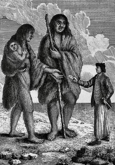
Magellan’s Strange Encounter With the 10-Foot Giants of Patagonia
You may have heard of the mythical, gigantic former inhabitants who wandered the wastes of Patagonia… The vision of a faraway land, inhabited by towering giants, has captured an enchanted European imagination for many years. But was Patagonia really the home to these larger-than-life folk, or was it no more than a myth spread by fantasists…?
The first mention of the giants, supposedly twice the height of the normal human being, appeared in the Italian chronicler Antonio Pigafetta’s account of Ferdinand Magellan’s travels.
This official record reported that Magellan’s crew got more than they bargained for during their circumnavigation of the globe in the 1520s.
Pigafetta details a dancing and leaping giant on the shores of Argentina. Not one to take all the glory for himself, Magellan selflessly sent a poor crew member over to the gallivanting giant to make contact…
The giant was reportedly very friendly, and so colossally tall that the Europeans only reached his waist. Magellan named them ‘patagones’, and many believe this to have come from the Portuguese word ‘pata’, meaning ‘foot’.
Ferdinand Magellan (1480-1521)
“Here, have this bread, so as not to eat me instead.
The so-called giants left huge, gaping footprints in the snow because of the large guanaco-skin moccasins they wore on their feet. Patagonia may thus mean ‘land of the bigfoot’, which unsurprisingly contributed to the rumours and mythologisation of the Patagonian giants. One other suggestion, however, is that Magellan took the name from the giant Patagón, a prominent character in the sixteenth-century Spanish chivalric romance Primaleón, which Magellan had more than likely read.
Spanish explorers of the day often took inspiration from a recent good read; indeed, ‘California’ came from a mythical island of the same name in another Spanish romance, Las Sergas de Esplandián). Magellan captured two of these giants to take back to Spain with him, but they sadly died on the homeward voyage.
Then a century on, in 1628, Sir Francis Drake’s nephew detailed his uncle’s circumnavigation in The World Encompassed and mentioned once more the legendary giant-dwellers of Patagonia… Drake the nephew suggested that, though the native people were far taller than any Europeans the crew had seen, perhaps Magellan’s crew had exaggerated the size of the Patagones, thinking it unlikely that anyone would ever go back to Patagonia to check, and indulging their friends and family by spinning a good yarn…
You can spot the gigantic Patagones on this contemporary map (not to scale)
But then in 1615, the Dutch circumnavigators Willem Schouten and Jacob Le Maire found graves containing human bones on the Patagonian shores… bones of beings which appeared to be ten or eleven feet tall…
Later on in 1766, Captain John Byron (grandfather to the poet) also circumnavigated the world and the story spread that the crew had encountered enormous, nine-foot giants.
Rumors flew furiously around Europe, and the line between fact and fiction grew increasingly blurred… There were bitter disputes between French and British scientists, the former believing that the latter were supporting the case for the existence of giants as a smokescreen, hiding what the French feared most: that British sailors were not really embarking on a giant-hunt in Patagonia, but rather scoping it out as an entry point to attack French territories in the New World.
It was in 1767 that the romantic vision of Patagonia as a wilderness hiding giants started to fade. French explorer Louis de Bougainville reported that the tallest Patagonian he came across was only 5ft 9in, and then, in 1773, the official account of the Byron voyage emerged… in reality, the so-called “giants” were only four inches taller than the most sky-scraping crew members.
The Tehuelche people
The Patagones is now thought to have been member of the indigenous Tehuelche tribe, a Mapudungun word meaning ‘Fierce People’. They are known to have been taller than the average European (who measured in at roughly five feet), and in all likelihood were the real Goliaths of Patagonia myth and legend.
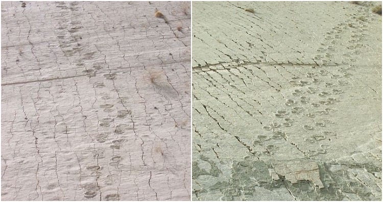
Limestone Wall In Bolivia Has Over 10,000 Dinosaur Footprints Belonging To 10 Different Species
Cal Orcko is a small town that is situated three miles south of the city of Sucre in Bolivia. It is home to the largest and most spectacular collection of dinosaur footprints of the Cretaceous era.
Even though the site remained closed for almost eight years after this paleontological discovery, it has been opened for visitors now.
A 300-foot-long limestone wall is located in Cal Orko, Bolivia, that has over 10,000 dinosaur footprints etched on it. The footprints belong to approximately 10 different dinosaur species that walked the earth about 68 million years ago. A 1.2-kilometre-long and 80-meter-high wall exists in Bolivia’s Cal Orko. The wall is a limestone slab that dates back to the dinosaur era.
It is covered with numerous dinosaur tracks that experts believe belong to approximately ten different species of dinosaurs. Currently, more than 10,000 individual dinosaur footprints have been identified on the limestone wall.
Christian Meyer, a Swiss palaeontologist, once commented that in 1998, they were able to recover only around 3,000 dinosaur tracks. Then in 2007, the number of footprints rose to 5,000, and in the latest survey, they have encountered over 10,000 individual dinosaur footprints in the limestone slab.
The most prominent tracks on the limestone wall are those of the quadrupedal titanosaurs. The tracks of the bipedal, carnivorous dinosaurs can also be found across the entire wall.
Other dinosaur species whose footprints were found on the wall include the theropods, ornithopods, ankylosaurs, and quadrupedal ornithopods.
The wall gives an impression that the dinosaurs were walking vertically. But in reality, the wall was originally the floor of a shallow lake from the Cretaceous period. It was due to tectonic movements that the floor became vertical.
Since the limestone slab is almost vertical, it gives the impression that the dinosaurs were walking vertically, like lizards on a wall. But experts have provided a more logical explanation. The limestone slab was originally the floor of a shallow lake of the Cretaceous era that once flowed through South America.
According to geologists, the floor of the lake has moved several times as a result of tectonic plate movement. Sixty-eight million years ago, the floor was walked upon by hundreds of dinosaurs leaving behind their footprints in the process.
The unique climate fluctuations at Cal Orko, Bolivia are believed to be the reason behind the spectacular presence of paleontological remains.
Why is it that there is such a concentration of dinosaurs remains in this area? Experts believe that it has something to do with the unique climatic fluctuations of the area. The large feet of the dinosaurs sank into the mushy shoreline of the lake that used to exist there.
When drought hit the area, the tracks solidified. Wet weather returned once again and sealed the footprints below layers of sediment and mud. Experts believe that this wet-dry pattern was repeated as many as seven times which led to the prints getting preserved on the floor of the lake.
And the best part was that tectonic activities shifted the floor into a vertical viewing angle, enabling this wonderful paleontological spectacle to be viewed by the species that continued living on this planet after the dinosaurs.
The Cal Orko Parque Cretacico hosts a museum, and models of dinosaurs, fossils, and related paleontological information and offers a guided, one-hour tour to a few selected areas of the dinosaur footprint wall.
Today, guided tours are offered to visitors to get a glimpse of the dinosaur footprints. Visitors are provided with a helmet as a safety requirement because of the cement factory that is located near the wall.
The guides point out the footprints of the Theropods (carnivorous dinosaurs) and Sauropods (long-neck herbivores). Lengths of the footprint trackways range from 26 feet to as long as an amazing 65 feet.
This amazing limestone slab serves as a record and offers a glimpse of the ever-changing history that took place in the Cretaceous era.
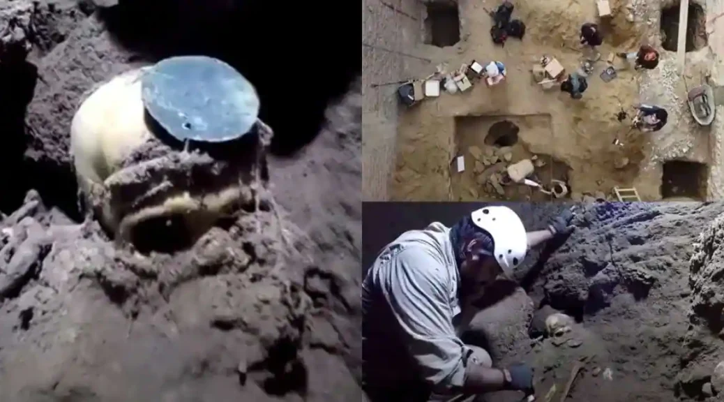
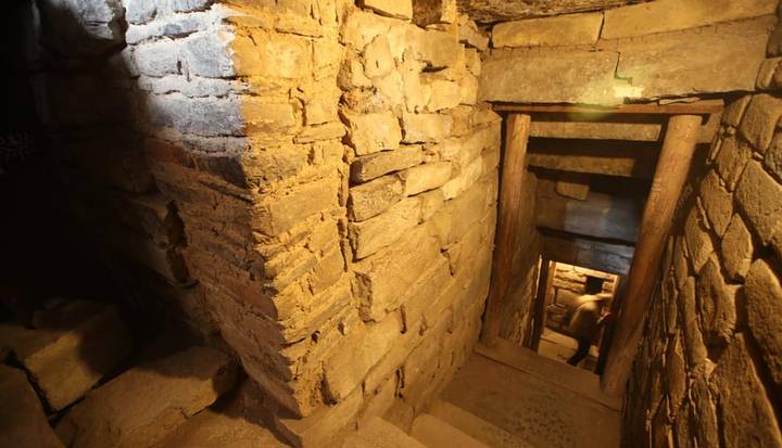
Archaeologists Find Massive Underground World Belonging To A Long Lost Civilization In Peru
Researchers in Peru have discovered a complex underground world belonging to the ancient Chavín culture that has been identified as burial chambers that date back thousands of years.
The culture developed in the northern Andean highlands of Peru between 1,300 and 550 BC. The Chavín extended its influence to other civilizations along the coast.
The Ancient Chavin civilization developed advanced knowledge not only in metallurgy, but in soldering, and temperature control. The ancient Chavin used early techniques to develop refined gold work.
Not, researchers have discovered galleries, ceramics and even a place where this civilization carried out burials, located beneath the surface. They say it’s the most important archaeological discovery made in the last 50 years.
Seen in this image are the new underground galleries that have been found containing the first human burials of the Chavin period.
Since June of 2018, a team of archaeologists has unearthed three new galleries in an area adjacent to the circular plaza of Chavín. In the place, they have found remarkable pieces of ceramics, utensils and intact human burials.
According to an American anthropologist and archaeologist John Rick, in charge of the Archaeological and Conservation Research Program of Chavín, the three discovered galleries come from the late period of this civilization that developed between 1,300 and 550 BC.
“What these galleries show is that Chavín has a much larger underground world than we think,” said Rick.
The Ministry of Culture estimates that to date only 15% of the area has been explored.
Inside one of these underground galleries, archaeologists discovered artefacts that belonged to the later Huaraz culture.
These successive occupations, found at different levels in the archaeological complex demonstrate the cultural and religious importance that Chavin had in the central highlands for centuries.
The project’s specialists used small robots with built-in micro-cameras to carry out the explorations. These machines – designed on-site by engineers from Stanford University – entered very small areas and discovered cavities in the Chavin labyrinths, where pottery was preserved.
Chavin de Huantar was designated a UNESCO World Heritage Site in 1985. So far 35 interconnected underground passageways have been found at the site, Peru’s culture ministry said.
Lost cities of the Amazon featuring terraces and PYRAMIDS are discovered
A massive urban landscape that contained interconnected campsites, villages, towns and monumental centres thrived in the Amazon rainforest more than 600 years ago.
Such low-density urban sprawl from pre-Columbian times was previously unknown in the Amazon or anywhere else in South America, say archaeologist Heiko Prümers of the German Archaeological Institute in Bonn and colleagues.
Rather than constructing huge cities densely packed with people, a substantial Casarabe population spread out in a network of small to medium-sized settlements that incorporated plenty of open space for farming, the scientists conclude.
Airborne lasers peered through dense trees and ground cover to identify structures from that low-density urban network that have long eluded land-based archaeologists.
Earlier excavations indicated that Casarabe maize farmers, fishers and hunters inhabited an area of 4,500 square kilometres. For about a century, researchers have known that Casarabe people fashioned elaborate pottery and constructed large earthen mounds, causeways and ponds. But these finds were located at isolated forest sites that are difficult to excavate, leaving the reasons for mound-building and the nature of Casarabe society, which existed from about the year 500 to 1400, a mystery.
Prümers’ team opted to look through the Amazon’s lush cover from above, aiming to find relics of human activity that typically remain hidden even after careful ground surveys.
The scientists used a helicopter carrying special equipment to fire laser pulses at the Amazon forest as well as stretches of grassland. Those laser pulses reflect data from the Earth’s surface. This technique, called light detection and ranging, or lidar for short, enables researchers to map the contours of now-obscured structures.
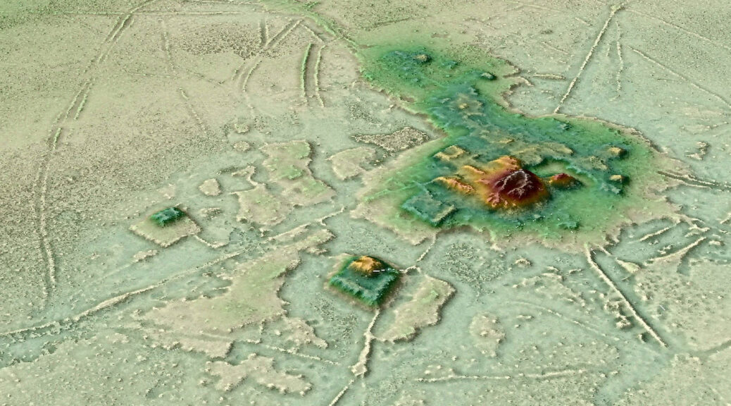
Looking at the new lidar images, “it is obvious that the mounds are platforms and pyramids standing on artificial terraces at the centre of well-planned settlements,” Prümers says.
The Lidar images revealed the cities architecture, consisting of stepped platforms topped by U-shaped structures, rectangular platform mounds, and conical pyramids
Two images of exactly the same area of the Salvatierra site. Left: a photo mosaic from drone footage; right: Lidar image. The discovery shows Amazonia was home to an early ‘urbanism’ created and managed by indigenous populations for thousands of years
Prümers’ team conducted lidar surveys over six parts of ancient Casarabe territory. The lidar data revealed 26 sites, 11 of them previously unknown.
Two sites, Cotoca and Landívar, are much larger than the rest. Both settlements feature rectangular and U-shaped platform mounds and cone-shaped earthen pyramids atop artificial terraces. Curved moats and defensive walls border each site.
Causeways radiate out from Cotoca and Landívar in all directions, connecting those primary sites to smaller sites with fewer platform mounds that then link up to what were probably small campsites or areas for specialized activities, such as butchering prey.
Lidar Image of the Cotoca site, revealing an array of elaborate and intricate structures unlike any previously discovered in the region, including 16ft-high terraces covering 54 acres – the equivalent of 30 football pitches – and 69ft-tall conical pyramids
The Casarabe society’s network of settlements joins other ancient and present-day examples of low-density urban sprawl around the world, says archaeologist Roland Fletcher of the University of Sydney.
These sites raise questions about whether only places with centralized governments that ruled over people who were packed into neighbourhoods on narrow streets, such as 6,000-year-old Mesopotamian metropolises, can be defined as cities.
Some past urban settlements organized around crop growing spanned up to 1,000 square kilometres or more in tropical regions. These include locales such as Southeast Asia’s Greater Angkor roughly 700 to 800 years ago and interconnected Maya sites in Central America dating to at least 2,300 years ago. Today, extended areas outside large cities, especially in Southeast Asia, mix industrial and agricultural activities over tens of thousands of kilometres.
Tropical forests that have gone largely unexplored, such as Central Africa’s Congo Basin, probably hosted other early forms of low-density urban development, Fletcher predicts.
Only further excavations guided by lidar evidence can begin to untangle the size of the Casarabe population, Prümers says. Whether primary Casarabe sites represented seats of power in states with upper and lower classes also remains unknown, he adds.
Casarabe culture’s urban sprawl must have encompassed a considerable number of people in the centuries before the Spanish arrived and Indigenous population numbers plummeted, largely due to diseases, forced labour and slavery says archaeologist John Walker of the University of Central Florida in Orlando.
Whatever Casarabe honchos had in mind as their tropical settlement network spread, he says, “we may have to set aside some of our strongly held ideas about what the Amazon is, and what a city is, to better understand what happened.”
“Dragon Of Death” Flying Reptile Found. It Lived 86 Million Years Ago
The fossilised remains of a huge flying reptile dubbed the ‘Dragon of Death’ – which lived alongside the dinosaurs 86 million years ago – have been unearthed in Argentina. Measuring about 30ft (9m) long, it is the largest pterosaur discovered in South America and one of the biggest flying vertebrates to have ever lived.
Researchers said the ‘beast’ would likely have been a frightening sight as it hunted its prey from prehistoric skies.
It is estimated the fearsome species lived at least 20 million years before an asteroid impact on what is now Mexico’s Yucatan peninsula wiped out about three-quarters of life on the planet 66 million years ago.
Giant beast: The remains of a huge flying reptile dubbed the ‘Dragon of Death’ – which lived alongside the dinosaurs 86 million of years ago – have been unearthed in Argentina
Researchers said the ‘beast’ would likely have been a frightening sight as it hunted its prey from prehistoric skies
Measuring about 30ft (9m) long, it is the largest pterosaur discovered in South America and one of the biggest flying vertebrates to have ever lived
A team of palaeontologists discovered the fossils of the newly-coined Thanatosdrakon amaru in the Andes mountains in Argentina’s western Mendoza province.
Project leader Leonardo Ortiz said the fossil’s never-before-seen characteristics required a new genus and species name, with the latter combining ancient Greek words for death (Thanatos) and dragon (drakon).
‘It seemed appropriate to name it that way,’ said Ortiz, of the National University of Cuyo in Mendoza.
‘It’s the dragon of death.’
The reptile was as long as a yellow school bus with an estimated wingspan of around 30ft (9m).
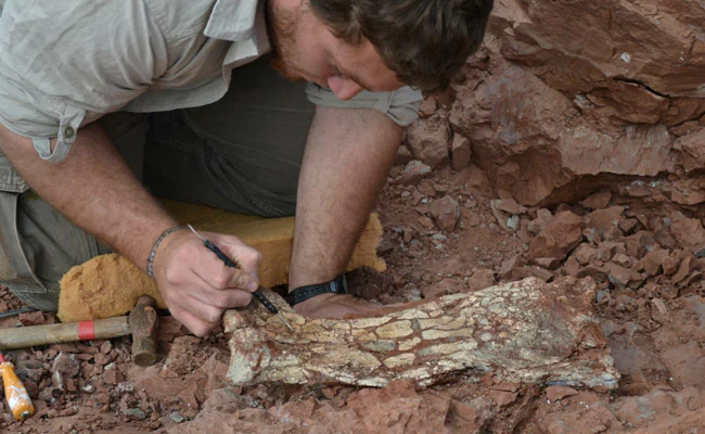
Some 40 bones and fragments were unearthed by the team of palaeontologists.
Some 40 bones and fragments were unearthed by the team of palaeontologists (pictured)
Researchers said the fossil’s huge bones classify the new species as the largest pterosaur yet discovered in South America and one of the largest found anywhere in the world
Project leader Leonardo Ortiz said the fossil’s never-before-seen characteristics required a new genus and species name
They said the fossil’s huge bones classify the new species as the largest pterosaur yet discovered in South America and one of the largest found anywhere in the world.
The researchers found that the rocks preserving the reptile’s remains dated back 86 million years to the Cretaceous period, which lasted from about 145 to 66 million years ago.
‘We don’t have a current record of any close relative that even has a body modification similar to these beasts,’ said Ortiz.
The researchers wrote in their paper that Thanatosdrakon ‘is the largest pterosaur that crossed the Cretaceous skies of South America discovered so far.
They said the discovery would allow scientists ‘to expand the knowledge about the anatomy of this diverse group of pterosaurs’.
Palaeontologists Unearth 139 Million-Year-Old Pregnant Dinosaur Fossil in Chile
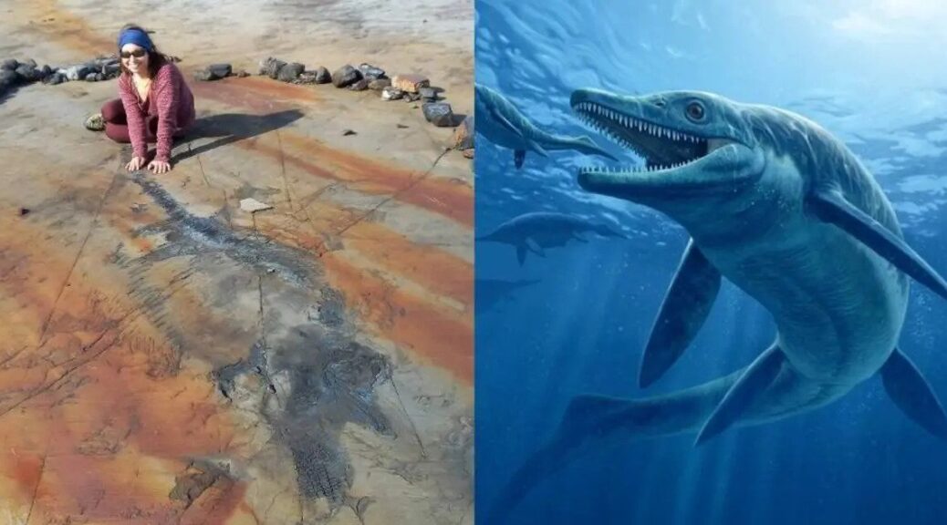
Archaeologists in Chile have unearthed the fossilized remains of a 13ft-long pregnant ichthyosaur from a melting glacier -marking the first time a complete ichthyosaur has been found in the country.
The 139-million-year-old fossil was carefully collected by helicopter following an expedition in March and April this year by the University of Magallanes (UMAG) in the Tyndall Glacier area of Chilean Patagonia.
Named ‘Fiona’ by scientists at the University of Manchester, the 139-million-year-old fossil died when she was pregnant and still had several embryos in her belly.
Ichthyosaurs were marine reptiles that lived in the age of dinosaurs, and Fiona is the only pregnant female of Valanginian-Hauterivian age – between 129 and 139 million years old from the Early Cretaceous period – to be excavated on the entire planet.
Dr. Dean Lomax, a palaeontologist working on the study, said: ‘The fact that these incredible ichthyosaurs are so well preserved in an extreme environment, revealed by a retreating glacier, is unlike anywhere else in the world.
The remains of the creature, which researchers from the University of Manchester have named Fiona, were unearthed from a melting glacier deep in Patagonia.
‘The considerable number of ichthyosaurs found in the area, including complete skeletons of adults, juveniles, and newborns provides a unique window into the past.’
Now, researchers are keen to find out what information they can gather from the incredibly rare find.
Fiona was first found in 2009 by Dr. Judith Pardo-Pérez, a Magellanic palaeontologist and UMAG researcher.
The team hopes to compare the ichthyosaurs found in the Tyndall Glacier with those previously found in Chilean Patagonia.
Collecting this specimen was not easy, as the glacier is within a 10-hour hike or horseback ride. The expedition lasted 31 days and was described by the researchers as an ‘almost titanic challenge.’
‘At four meters long, complete, and with embryos in gestation, the excavation will help to provide information on its species, on the palaeobiology of embryonic development, and on a disease that affected it during its lifetime,’ said Dr. Judith Pardo-Perez, who led the study.
Alongside Fiona, 23 other new specimens were discovered during the expedition, making the Tyndall Glacier the most abundant ichthyosaur graveyard in the world, according to the team.
Ichthyosaurs.
Alongside Fiona, 23 other new specimens were discovered during the expedition, making the Tyndall Glacier the most abundant ichthyosaur graveyard in the world, according to the team.
Fiona will now be prepared in the palaeontology laboratory of the Río Seco Natural History Museum in Punta Arenas, where it will be temporarily stored for later exhibition.