Remains at Bronze Age Funeral Pyre in Italy Analyzed
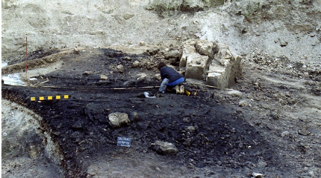
A team of anthropologists studying Salorno, a stretch of scorched earth in northern Italy, say the site is a Late Bronze Age cremation platform where the remains of at least 172 individuals may have been burned. What’s more, the researchers believe the remains were simply left on the ground for the last 3,000 years.

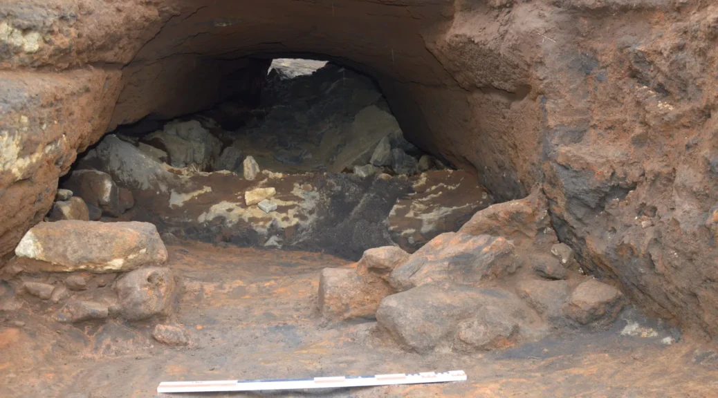
The site is called Salorno—Dos de la Forca, and it dates from 1150 BCE to 950 BCE. Besides the cremains (cremated remains) researchers found charred animal bone fragments, pottery shards, and bronze burial goods.
There was also a uniquely shaped boulder on the site (seen in the image above); it’s unknown whether it had any ceremonial purpose.
Though Salorno was first excavated in the 1980s, researchers only recently completed a bioanthropological analysis of the remains on the site. The team’s analysis was published last week in PLoS One.
“What is interesting at Salorno is that different from contemporary known cemeteries characterised by fields of cinerary urns or burials, this site appears as something very different: a pyre of dead bodies that were not selected for burial but intentionally left in the open, commingled with offerings and their own personal goods,” said Federica Crivellaro, a bioanthropologist at Stony Brook University and a co-author of the recent paper, in an email to Gizmodo.
“Salorno must have been a ‘sacred’ place for its community, in the way it was chosen but also protected from being looted or destroyed, but we cannot assess why exactly,” she added. “The fact that it serendipitously was preserved till today is simply very special.”
The site is a ustrinum, Latin for a cremation platform. Cremation was a widespread means of disposing of bodies in the Late Bronze age, but often the remains would be buried after they were burned.
At Salorno, they were simply left in situ, setting the site apart from other ustrina.

Crivellaro’s team looked at the number of human remains and calculated the likely number of individuals that were burned on the site at between 48 and 172, based on the total mass of the cremains. (The number of individuals represented at the site depends on whether all individuals were cremated and left in situ, or some bones were later buried elsewhere.)
In any case, the team knows the individuals were burned because of the bones’ condition (specific cracks in the fragments indicate heat-induced trauma) as well as their white colour (a shade distinct from ordinary, hydrated bones), which suggests the pyre temperatures may have exceeded 1292° Fahrenheit (700° C). The site was used over a couple of centuries, judging from the style of grave goods and pottery found on the site.
Because the individuals at Salorno were burned, it’s difficult to discern whether they were all related genetically.
“Cremated human remains are never sexy for traditional physical anthropology as they are fragmented, deformed, and skeletons and teeth are normally depleted of DNA,” Crivellaro said.
But based on the quality of the goods, and the sizes of contemporary settlements in the area, the team posited that the individuals burned and left in Salorno may have been a small number of nuclear families or a group of local elites.
Though the researchers don’t know who started the fire, they know it burned for about 200 years and incinerated nearly 50 people at a minimum in that time. ‘Ashes to ashes, dust to dust’ takes on a new meaning when the remains are left right where they were burned; if not fodder for worms, the remains are great fodder for archaeologists.