Study Suggests Hominin Could Walk and Swing Through Trees
Gizmodo reports that a new study of a human ancestor’s shoulder blade and collarbone suggests that Australopithecus Prometheus was able to swing through trees some 3.7 million years ago.
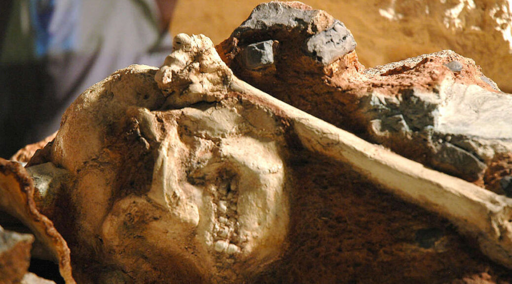
Discovered in South Africa in the 1990s, the fossilized remains of an individual known as “Little Foot” were carefully excavated from the concrete-like rock over a period of 15 years.
The specimen called StW 573 or Little Foot, was an Australopithecus Prometheus.
A cast of Little Foot in 2005. It would take over a decade for the real thing to be fully excavated.
The fossil was finally fully excavated in 2018, over 20 years after its discovery when palaeontologists finished extricating the fossil from the breccia it was encased in. Immediately, Little Foot offered a remarkable glimpse into human origins.
Research describing the shoulder joint’s morphology was published this week in the Journal of Human Evolution. The research team inspected Little Foot’s pectoral girdle: literally, the specimen’s shoulder blade and collar bone.
By comparing the girdle’s formation to that in other human relatives, including some of the great apes, the team sussed out how Little Foot and others in its species got around.
“By understanding how the shoulder joints of early hominins are structured, and more broadly how their shoulder blades are capable of moving on their torsos, we can understand how they used their upper limbs while interacting with the environment,” said Kristian Carlson, a biological anthropologist at the University of Southern California and lead author of the new paper, in an email. “This is a crucial question during this period of our evolutionary history.
In its subtle shape, the pectoral girdle of Little Foot indicated to the researchers that the hominin did exploit trees for its survival, perhaps for acquiring a meal or to avoid becoming one. That lines up with research last year on the specimen’s vertebrae, which suggested Little Foot was capable of head movements (useful for climbing) that go beyond modern human capacities. That said, Little Foot was still bipedal, featuring the upright gait associated with humans.
The new finding brings up an interesting comparison with Ardi (a specimen of Ardipithecus ramidus), a lesser-known ancient relative from 4.4 million years ago.
Paleoanthropologists recently suggested that Ardi’s hands were built for swinging in trees, though some experts disagreed, saying Ardi was more human-like than ape-like.
Though the fossil record is as ossified as can be, the conclusions drawn from the bones we pull from the ground remain fickle. It’ll take some time to see whether the interpretations of Little Foot’s lifestyle, drawn from these shoulder bones, stick.
Little Foot’s bones suggested it hadn’t lost its ability to swing through trees.
Little Foot’s pectoral girdle is the earliest evidence of such a skeletal structure so close to when hominins split off from ape and bonobo ancestors. That upper limb is a crucial piece of the puzzle, though Carlson said it can only tell us so much.
“As special as Little Foot is, it is only one individual,” he explained. “While we are still intensely investigating other anatomical regions of the Little Foot skeleton, we also must continue to appreciate the growing morphological variability that appears to exist within the early hominin fossil record, for example in Australopithecus.”
Based on their comparisons, Carlson’s team determined that Little Foot’s shoulder structure may be a good indicator for what that structure looked like in even older human relatives, in the 7- to 8-million-year-old time frame.
Such a discovery would make Little Foot look like a spring chicken. But until that happens, looks like we’re stuck with one of the most complete Australopithecine fossils ever found, the continued analysis of which reveals new details and theories with each pass. Woe is us!
Dead Sea Scroll Analyzed With Artificial Intelligence
According to a statement released by the University of Groningen, Mladen Popović, Lambert Schomaker, and Maruf Dhali used a computer algorithm to analyze the Great Isaiah Scroll, which was discovered in Qumran Cave 1 in 1947.
The Great Isaiah Scroll is over 7 metres long and the most complete of the Dead Sea Scrolls.
However, since the scribes are anonymous, scholars have been unable to identify the individuals behind the scrolls. The University of Groningen researchers have cracked the code, allowing them to uncover the scribes behind the scrolls, by combining science and the humanities. On April 21, they published their findings in the journal PLOS ONE.
The scribes who created the scrolls did not sign their work. Scholars suggested some manuscripts should be attributed to a single scribe based on handwriting. ‘They would try to find a “smoking gun” in the handwriting, for example, a very specific trait in a letter which would identify a scribe’, explains Mladen Popović, professor of Hebrew Bible and Ancient Judaism at the Faculty of Theology and Religious Studies at the University of Groningen.
Two 12×12 Kohonen maps (blue colourmaps) of full character aleph and bet from the Dead Sea Scroll collection. Each of the characters in the Kohonen maps is formed from multiple instances of similar characters (shown with a zoomed box with red lines). These maps are useful for chronological style development analysis. In the current study of writer identification, Fraglets (fragmented character shapes) were used instead of full character shapes to achieve more precise (robust) results.
He is also director of the university’s Qumran Institute, dedicated to studying the Dead Sea Scrolls. However, these identifications are somewhat subjective and often hotly debated.
Scribes
That is why Popović, in his project The Hands that Wrote the Bible which was funded by the European Research Council, teamed up with his colleague Lambert Schomaker, professor of Computer Science and Artificial Intelligence at the Faculty of Science and Engineering.
Schomaker has long worked on techniques to allow computers to read handwriting, often from historical materials. He also performed studies to investigate how biomechanical traits, like the way in which someone holds a pen or stylus, would affect handwriting.
In this study, together with PhD candidate Maruf Dhali, they focused on one scroll in particular: the famous Great Isaiah Scroll (1QIsaa) from Qumran Cave 1. The handwriting in this scroll seems near-uniform, yet it has been suggested it was made by two scribes sharing a similar writing style. So how could this be decided? Schomaker: ‘This scroll contains the letter aleph, or “a”, at least five thousand times. It is impossible to compare them all just by eye.’ Computers are well suited to analyse large datasets, like 5,000 handwritten a’s. Digital imaging makes all sorts of computer calculations possible, at the microlevel of characters, such as measuring curvature (called textural) and whole characters (called allographic).
Authors of the new paper Mladen Popovic (far left) and Maruf A Dhali (middle) with other collaborators at the Qumran Caves, where the scroll was found.(Supplied)
Neural network
‘The human eye is amazing and presumably takes these levels into account too. This allows experts to “see” the hands of different authors, but that decision is often not reached by a transparent process,’ Popović says. ‘Furthermore, it is virtually impossible for these experts to process the large amounts of data the scrolls provide.’ That is why their results are often not conclusive.
The first hurdle was to train an algorithm to separate the text (ink) from its background (the leather or the papyrus). For this separation, or ‘binarization’, Dhali developed a state-of-the-art artificial neural network that can be trained using deep learning. This neural network keeps the original ink traces made by the scribe more than 2,000 years ago intact as they appear on digital images. ‘This is important because the ancient ink traces relate directly to a person’s muscle movement and are person-specific, Schomaker explains.
Similarities
Dhali performed the first analytical test of this study. His analysis of textural and allographic features showed that the 54 columns of text in the Great Isaiah Scroll fell into two different groups that were not distributed randomly through the scroll, but were clustered, with a transition around the halfway mark.
With the remark that there might be more than one writer, Dhali then handed the data to Schomaker who then recomputed the similarities between the columns, now using the patterns of letter fragments. This second analytical step confirmed the presence of two different. Several further checks and controls were performed. Schomaker: ‘When we added extra noise to the data, the result didn’t change. We also succeeded in demonstrating that the second scribe shows more variation within his writing than the first, although their writing is very similar.’
Handwriting
In the third step, Popović, Dhali, and Schomaker have produced a visual analysis. They created ‘heat maps’ that incorporate all the variants of a character across the scroll. Then they produced an averaged version of this character for the first 27 columns and the last 27 columns. Comparing these two average letters by eye shows that they are different. This links the computerized and statistical analysis to human interpretation of the data by approximation because the heatmaps are neither dependent nor produced from the primary and secondary analyses.
Certain aspects of the scroll and the positioning of the text had led some scholars to suggest that after column 27 a new scribe had started, but this was not generally accepted. Popović: ‘Now, we can confirm this with a quantitative analysis of the handwriting as well as with robust statistical analyses. Instead of basing judgment on more-or-less impressionistic evidence, with the intelligent assistance of the computer, we can demonstrate that the separation is statistically significant.’
New window
In addition to transforming the palaeography of the scrolls – and potentially other ancient manuscript corpora – this study of the Great Isaiah Scroll opens up a totally new way to analyse the Qumran texts based on physical characteristics. Now, researchers can access the microlevel of individual scribes and carefully observe how they worked on these manuscripts.
Popović: ‘This is very exciting because this opens a new window on the ancient world that can reveal much more intricate connections between the scribes that produced the scrolls. This study found evidence for a very similar writing style shared by the two Great Isaiah Scroll scribes, which suggests a common training or origin. Our next step is to investigate other scrolls, where we may find different origins or training for the scribes.’
In this way, it will be possible to learn more about the communities that produced the Dead Sea Scrolls. ‘We are now able to identify different scribes’, Popović concludes. ‘We will never know their names. But after seventy years of study, this feels as if we can finally shake hands with them through their handwriting.’
Additional information:
Digital images of the Dead Sea Scrolls and of the Great Isaiah Scroll were kindly provided by Brill Publishers and the Israel Antiquities Authority (the Leon Levy Dead Sea Scrolls Digital Library).
The Dead Sea Scrolls were found in jars like this.
Reference: Mladen Popović, Maruf A. Dhali, and Lambert Schomaker, Artificial Intelligence Based Writer Identification Generates New Evidence for the Unknown Scribes of the Dead Sea Scrolls Exemplified by the Great Isaiah Scroll (1QIsaa)
Iron Age Weapons Found at Hillfort Site in Germany
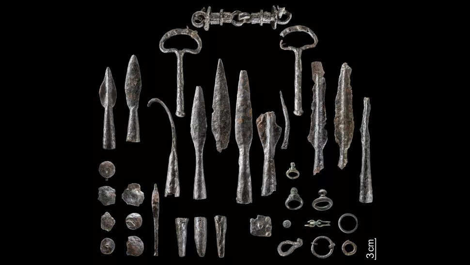
Live Science reports that a metal detectorist working with the Regional Association of Westphalia-Lippe archaeologists has discovered more than 150 objects at Wilzenberg, an Iron Age hillfort site in western Germany.
Some of the bent weapons that were found during the 1950s at the hillfort in western Germany.
The hoard contains more than 150 objects, including deliberately bent weapons, such as 40 spearhead and lancehead tips, swords and fragments of shield bosses (round structures at the centre of a shield); tools; belt hooks; horse gear; three silver coins; bronze jewellery; and one fibula, or lower leg bone, Manuel Zeiler, an archaeologist at LWL, told Live Science.
“The arsenal is the largest in [the German state of] North Rhine-Westphalia and also links the [state’s region of] Sauerland with complex processes in Iron Age Europe,” Michael Baales, an LWL archaeologist and head of the Olpe branch in North Rhine-Westphalia, said in a translated statement, released March 31.
Moreover, the damaged weapons — which ancient people would have purposefully destroyed by bending them — shed light on how victorious Iron Age warriors treated the losing side’s arsenal, Baales said.
Researchers have known about a possible hoard at the Iron Age hillfort for several decades. In the 1950s, while workers were constructing a pavilion, “two swords wrapped in two spearheads and two lanceheads were discovered by chance,” Zeiler said.
The swords were bent, and their tips had been purposefully deformed, he noted. But it wasn’t until 2013 that archaeologists did a more thorough excavation at this spot to discover the full context of the archaeology there, Zeiler said.
From 2018 through 2020, metal detectorist and local history researcher Matthias Dickhaus, who worked with the LWL and the town of Schmallenberg, searched the site for additional metal artifacts.
In all, Dickhaus hit the jackpot, finding 100 objects, the LWL reported. Among the findings, archaeologists marvelled over a rare type of horse bridle.
“The existing handle parts for guiding the horse suggest that this type of bridle was used on horses that were pulling a chariot,” the LWL wrote in the statement. “The bit allowed the horse to be steered very precisely and directly — vital for a warrior on a chariot in the thick of a battle.”
A metal detectorist found these artifacts and more as he searched the site at Wilzenberg from 2018 to 2020.
Left: A rare horse bridle that has two side handles with which the rider could guide the horse; Right: Belt hooks like this one, shown from different angles, are among the few non-iron objects in the hoard.
The hillfort, Zeiler added, is located on the 2,158-foot-tall (658 meters) Wilzenberg mountain. This site was visited by people during the Iron Age, from about 300 B.C. to the birth of Christ, and the walls of the ancient hillfort, known as the Wallburg, are still visible today, largely seen by pilgrims and hikers who frequent the mountain.
Most of the artifacts from the hoard date to about 300 B.C. to the first century B.C., although the coins and the swords had a more narrow window of only the first century B.C., Zeiler said.
A view to the northeast of Wilzenberg mountain in the German state of North Rhine-Westphalia.
Although the hillfort at Wilzenberg is far away from the centres of Celtic culture in other parts of continental Europe, its architecture and the hoard’s bent objects are “comparable with the Celtic culture,” Zeiler noted.
Celtic and other Iron Age cultures are known to have bent the weapons of a defeated enemy in a similar way to the newfound hoard. For instance, archaeological investigations at sanctuaries in Gournay and Ribemont-Sur-Ancre in France “shows that weapons of conquered warriors after the battle were destroyed by the winner,” Zeiler said. “This ceremony was possibly the last step to celebrate the triumph.”
The new analysis of the hoard shows that “far away from the Celtic civilization, people celebrated a triumph after battle similar to the Celtic world,” Zeiler told Live Science.
Despite the many weapons and parts of horse gear found at the hillfort, there’s no evidence of an epic battle there, Zeiler noted.
“The damage was clearly not caused during a fight, and consequently the Wilzenberg is not a battlefield,” Zeiler said in the LWL statement. Many of the weapons cannot be precisely dated, so it’s not clear whether they were damaged and laid down over the centuries, or whether they were deliberately twisted at a single event, he said.
The Mystery of the Giant Crystals: How the 36-foot Geode of Pulpí Formed
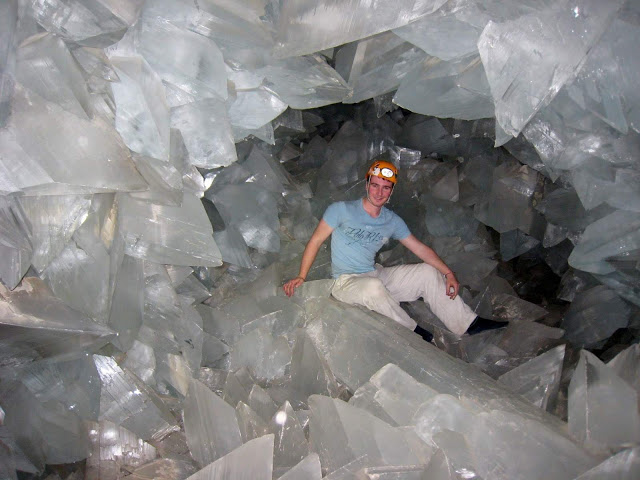
In an abandoned mine in southern Spain, there is a room of pure crystal. You have to go to a deep tunnel, get into a ladder in the rocks, and squeeze across a jagged gypsum crystal tube that is barely wide enough for a person. If you make it that far, you’ll be standing inside the world’s largest geode: the Pulpí Geode, a 390-cubic-foot (11 cubic meters) cavity about the size of a cement mixer drum, studded with crystals as clear as ice and sharp as spears on every surface.
This is the geode of Pulpí
While you may have never stood inside a geode, you’ve probably held, or at least seen, one before.
“Many people have little geodes in their home,” Juan Manuel García-Ruiz, a geologist at the Spanish National Research Council and co-author of a new paper on the history of the Pulpí Geode, told BBC. “It’s normally defined as an egg-shaped cavity inside a rock, lined with crystals.”
A researcher stands inside the crystal-filled cave known as the Pulpí Geode
Those crystals can form after water seeps through tiny pores on a rock’s surface, ferrying even tinier minerals into the hollow interior. Depending on the size of the rock cavity, crystals can continue growing for thousands or millions of years, creating caches of amethyst, quartz and many other shiny minerals.
The crystal columns at Pulpí are made of gypsum — the product of water, calcium sulfate, and lots and lots of time — but not much else has been revealed about them since the geode’s unexpected discovery in 2000.
In a study published in the journal Geology, García-Ruiz and his colleagues attempted to shed some new light on the mysterious cave by narrowing down how and when the geode formed.
García-Ruiz is no stranger to giant crystals. In 2007, he published a study on Mexico’s fantastical Cave of Crystals, a basketball-court-size cavern of gypsum beams as big as telephone poles buried 1,000 feet (300 m) below the town of Naica.
Uncovering the history of that “Sistine Chapel of crystals,” as García-Ruiz called it, was made easier by the fact that the crystals were still growing in the mine’s humid bowels.
At Pulpí, however, the mine was completely dry, and the geode’s crystals had not grown in tens of thousands of years. On top of that, the geode’s gypsum spikes are incredibly pure — so translucent that “you can see your hand through them,” García-Ruiz said.
This means they do not contain enough uranium isotopes to perform radiometric dating, a standard method of analyzing how different versions of elements radioactively decay to date very old rocks.
“We had no idea what happened,” García-Ruiz said. “So, we were required to make a cartography of the entire mine to understand its very complicated geology.”
The researchers analyzed and radiometrically dated rock samples around the mine for seven years to figure out how the area had changed since its formation hundreds of millions of years ago. The team’s driving question: Where did the calcium sulfate in the Pulpí Geode come from?
Ultimately, the researchers narrowed down the geode’s formation to a window of about 2 million years (not bad for the 4.5-billion-year-old calendar of geologic time). The crystals must be at least 60,000 years old, the team found because that was the youngest age of a bit of carbonate crust growing on one of the largest crystals in the geode. Since the crust is on the outside of a crystal, the crystal below must be even older, García-Ruiz explained.
Meanwhile, the composition of other minerals in the mine suggests that calcium sulfate was not introduced to the area until after an event called the Messinian Salinity Crisis — the near-total emptying of the Mediterranean Sea that is believed to have occurred about 5.5 million years ago.
Based on the size of the gypsum crystals, it’s likely they started forming less than 2 million years ago, through a very slow-growing process called Ostwald ripening, in which large crystals form through the dissolution of smaller ones, García-Ruiz said. For an everyday example of this process, peer into your freezer.
When ice cream ages past its prime, small ice crystals begin to break away from the rest of the treat. As more time passes, those small crystals lose their shape and recombine into larger crystals, giving the old ice cream a distinctly gritty texture.
The Pulpí Geode may not be as tasty as ice cream, but merely knowing that magical places like this exist comes with its own sweet satisfaction.
Thanks in part to the research team’s mapping efforts, tourists are now allowed to visit the Pulpí Geode, and García-Ruiz certainly wouldn’t blame you for doing so. Squeezing past the jagged gypsum gateway and into the geode’s cavity for the first time several years ago, García-Ruiz recalled one feeling: “euphoria.”
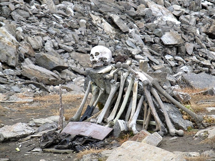
The view of an enormous pile of skulls and bones tangled under the water surface is quite enticing. You wonder who they are, and especially how they came here first because that lake is 16,000 feet above sea level and there is nothing more than ice tops and frozen glaciers around it.
The roopkund lake.
Every year, the ice melts and shows the human remains of more than 300 unfortunate people who rest at the bottom of the Roopkund, better known as the Skeleton Lake. This frozen, frozen, shallow lake is hidden deeper into the Indian Himalayas.
This “spectacular” view can be enjoyed in the core of the dark forest of Lohajung in Uttarakhand, India, by any enthusiastic trekking enthuse who wishes to walk down the steep path up to the glacier lake, which most of the moment is frozen, in a tiny valley elevated in the Garhwal section of the Himalayas.
Roopkund Lake contains hundreds of skeletons and is flanked by sheer cliffs.
The remains of an estimated 600-800 people have been found at the site
However, the ice begins to melt and the surface begins to see for a month when the temperature is sufficiently friendly. Then, the six-foot-deepest depth of the lake demonstrates what lies underneath the small and apparently typical natural wonders.
This is a death-ground filled with skeletons and not only that, but also the hair, nails, spears, knives, and gems, preserved by the frosts as if these souls had been decimated and found mysteriously their way into the bottom of this lake.
This stunning mystery has been tried by scientists, anthropologists, and historians to unravel. In 1942when the contents of the lake were first found by a British forest guard, Remains of unfortunate Japanese soldiers passing through the mountains were believed to be recent humans.
On the snow just outside the lake, the guard stumbled over a human skull, and on the basis of the preservation with a complete bunch of hair, it took on the most probable scenario. He submitted a report soon after finding more skeletons nearby and below the frozen lake surface.
And his hypotheses seemed logical at first. But there was no inquiry of the bones, and nobody knew who they were, what they were and what had occurred. So obviously, in moments of conflict, the authorities had the same initial conviction that these are the residues of a military battalion that passed through the hills in the direction of India.
But all these first impressions came down the drain after a more thorough inquiry when spears and all sorts of various old arms or bars were discovered lying next to the bones, and it was evident comprehensive research of the remains needed to be done.
The mystery had been unresolved for some moment and many theories were brought to life about what had occurred. People even accepted a local faith in an old goddess who would lay waste to a group of individuals who defied her.
The legend says that this goddess was so furious by the group of people who ostensibly passed by her unspoiled shrine in the mountains that she flung iron hailstones over these petty disrespectful people and killed them on the spot. The legend said she was so furious.
In recent studies, it has been found, in fact, that the skulls and their shoulders have clear signs of round-shape blows as if they had been struck from above. In 2004, the lake received samples and research from an expedition led by a team of Indian scientists with a few Europeans.
During the progress of DNA testing, the bones and some of the preserved human tissue could now be examined. The common belief was that the skeletons were the remains of people who over the years were killed by severe weather and sudden storms on the hills and slipped into the lake with snow, which prevented the natural process of decomposition.
Human skeletons at Roopkund Lake.
Although the bodies discovered that their height and body are distinguished, Almost all remains from the same time, at about 850 A.D., are found in the Radiocarbon Accelerator Unit of the University of Oxford, UK. In addition, two separate body types with similar DNA were found.
A group of smaller and thinner people and one completely the opposite. This resulted in them thinking it had to be a pilgrimage group or a kind of mountain excursion which hired local guides. Sadly, a baseball-style hail storm murdered them on their manner trapped in a valley and nowhere to find a shelter. That’s the recent scientific research at least.
One group of shorter individuals with smaller and thinner bones, and one completely the opposite. Which led them to believe that it must have been a group on pilgrimage or some kind of expedition in the mountains that hired some local guides. Unfortunately for them, trapped in a valley, and nowhere to be found with shelter, they were killed by a baseball-sized hail storm. This, at least, is based on recent scientific research.
According to the historical Himalayan legend of the ancient goddess, a king went on a pilgrimage in India to the Nanda Division Raj Jat Festival only once every 12 years, with his spouse, family, servants, musicians and others.
They hired locals to help them get there, but along the way, and despite locals telling them otherwise, the goddess Nanda Devi was angry and punished with their loudness. But most of all, a pregnant woman was in the group that presumably gave birth in the sacred land of the goddess. The newborn was the biggest sin of all and she had “hard-as-iron” sent out a storm of hailstones and murdered them.
This shrine in honor of Nanda Devi lies along the trail to Roopkund Lake.
Although it wasn’t the goddess ‘ wrath, it was certainly the fury of what killed hundreds of people. At least part of a legend clarified the mystery well before science. That means something completely distinct until more information and further research are revealed. This should be followed by a science or academic institution because sadly all trekking passers-by pick a bone or two as souvenirs, and very shortly there might be nothing left to be studied.
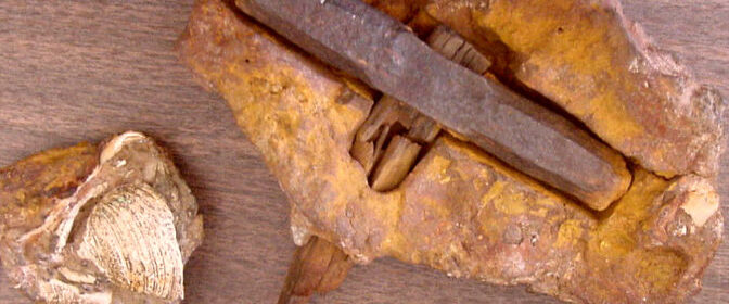
400 Million Year Old Hammer discovered In Texas The London
This curious artefact was found in London, Texas, USA in 1934. The hammer was embedded in the rock and has been many theories about its origin, and most importantly its incredible age.
So how did the hammer end up being stuck in the rock? Well, to finish the hammer inside the rock it had to be built before the rock was formed and which was several million years ago.
After their discovery and all the questions raised by the hammer, the researchers decided to abandon the unbelievable discovery at the Somervell Museum in Texas.
The internal handle underwent the process of carbonization based on studies by the Metallurgical Institute of Columbia and the hammerhead was built with iron purity only achievable with modern-day technology.
According to analysis, the head of the hammer consists of 97 pure iron, 2 per cent chlorine and 1 per cent sulfur. Surprisingly researchers also found that the iron had undergone a process of purification and hardening, typical of the metallurgy of the twentieth century.
According to analysis, the rock encasing of the hammer was dated to the Ordovician era, more than 400 million years ago.
The portion of stone surrounding the hammerhead also presented abnormalities, seeming to have merged with some type of sheath covering the hammer. According to geologists, the slow process of petrification dates back hundreds of millions of years.
This has led several ufologists and ancient astronaut theorists to a quick deduction of the context of the incredible discovery leading them to assume not only that there was a human civilization before the historical process of petrification in Texas, but that this ancient civilization already possessed the necessary technology for the fabrication of a hammer with modern features.
Evidence suggesting that the iron from the hammer might have originated from a meteorite is not a possibility according to researchers. The chemical analysis of the artefact also detected certain amounts of potassium, silicon, chlorine, calcium and sulfur.
Thus, this composition contradicts the hypothesis postulated that the hammerhead belonged to the fragment of a meteorite since the bodies of our solar system do not have that type of chemical composition.
Researchers also believe, that since the head of the hammer was found embedded into the rock, it suggests that the embedding process was performed under different atmospheric conditions to the current, different atmospheric pressure, more similar to those in the remote past.
Against the remote possibility that a meteorite with extremely rare and bizarre chemical composition and exceptional morphology, got caught, in prehistoric times, onto a piece of wood just as the head of the discovered hammer imprisons its handle, some researchers and ancient astronaut theorists point toward the fact that our planet was inhabited in ancient times, by civilizations with advanced technical and technological capacity, of which today we only have legends and items like this one who were trapped in the rock.
Unfortunately, some scientists do not agree with the theory that an ancient civilization created the hammer, and claim that it was only a metallurgical technique that had been eventually abandoned.
This extraordinary artefact belongs to the list of many other mysterious objects that have been discovered across the globe, and just like the Russian “microchip” or the 300 million-year-old screw, this item has caused debate among researchers and historians who are divided into groups, supporting and denying the possibility that the human race is much older than previously thought.
Whether this artefact is indeed a hammer dating back hundreds of millions of years, is something that will fuel debate among supporters of the ancient astronaut theory and conventional archaeologists, who both have provided arguments explaining the origin and age of the hammer.
Egypt breakthrough: How 2,000-year-old mystery was solved after ‘lost labyrinth’ discovery
The discovery was made in Dahshur, an archaeological site 90km south of Cairo, where the tattered remains of Pharaoh Amenemhat III’sBlack Pyramid can be seen today. The huge mortuary temple that originally stood adjacent to this pyramid is believed to have formed the basis of the complex of buildings with galleries and courtyards called a “labyrinth” by famed ancient Greek historian Herodotus.
With no visible remains, the story was thought to simply be a legend passed down by generations until Egyptologist Flinders Petrie uncovered its “foundations” in the 1800s, leading experts to theories the labyrinth was demolished under the reign of Ptolemy II and used to build the nearby city of Shedyt to honour his wife Arsinoe. But, in 2008, archaeologists working on the Mataha Expedition made a stunning find below the sands, researcher Ben Van Kerkwyk revealed on his YouTube channel ‘UnchartedX’ earlier this year.
He said in January: “It is a rare thing for ancient historical mysteries to ever be fully resolved.
“Great enigmas like the pyramids of Egypt seem to somehow resist the passage of time, unchanging as it flows around them like boulders in the river of history.
“Occasionally our civilisation makes some small incremental progress, a new tomb is found or some object discovered destined to become yet another piece in a museum.
The Black Pyramid is located in Dashu
“12 years ago, in 2008, a momentous discovery was made beneath the sands of Egypt, this wasn’t some small incremental step, but represented rather a huge leap forward – an opportunity for historical exploration and learning – the likes of which we have not witnessed in a century.
“The great lost labyrinth of ancient Egypt had been found.”
Mr Van Kerkwyk went on to detail what the area may have looked like some 2,000 years ago.
He added: “This was a gigantic and mythical structure, said by some to have surpassed the achievements of the pyramids, a huge array of thousands of underground halls, temples and chambers, dwarfing all known Egyptian temple sites several times over.
“This structure was visited and witnessed first-hand by the great historians of millennia past, yet ultimately, was lost to the sands of the desert and its physical presence remained unknown for more than 2,000 years.
A huge labyrinth is believed to be below the sand
“Unknown until 12 years ago, the discovery was suppressed and today the incredible potential of this site is being slowly and irrevocably destroyed by both inaction by authorities and by the water table in the area that’s rising.
“Compared with Giza or any of the other well-known ancient Egyptian sites, there really isn’t a lot to immediately take in.”
Mr Van Kerkwyk detailed how Mr Petrie first stumbled across the find.
He added: “Some fragments of once-mighty granite columns carved in palm or lotus shapes along with other small fragments of ancient stonework are left lying in a small, open-air museum.
“The site is dominated by the remains of the pyramid of Amenemhat III with only the mud-brick internal structure remaining to see.
Possible location of the tunnels
“The remains of the labyrinth have been discovered in the sandy areas to the south of the pyramid.
“The first to find any real evidence of this was the great Flinders Petrie, who, in the late 1800s, discovered the remains of a huge stone foundation, more than 300 metres broad around four metres beneath the sand.
“He concluded that this was the remnants of the foundations for the labyrinth, with the structure itself being long since quarried and destroyed.”
Archaeologists found evidence of a huge structure hiding below the sand in 2008, but Mr Van Kerkwyk said the area has never been excavated.
The monuments cannot be seen today
There are few ancient remains visible
He continued: “However, new evidence collected in modern times is challenging his conclusion and it now seems likely that what Petrie found was not the foundation, but instead was part of the ceiling or roof.
“These same areas were scanned in 2008, using ground-penetrating radar, by the Mataha Expedition, a collaboration between Egyptian authorities, the Ghent University of Belgium and funded by contemporary artist Louis De Cordier.
“The results of this expedition clearly indicate the presence of grid-like and ordered structures deep beneath the sand in levels much deeper than Petrie ever excavated.
“Although this expedition was conducted with the full cooperation and permission of the Supreme Council of Antiquities, the official results and conclusion of this legitimate scientific study have never been released.”
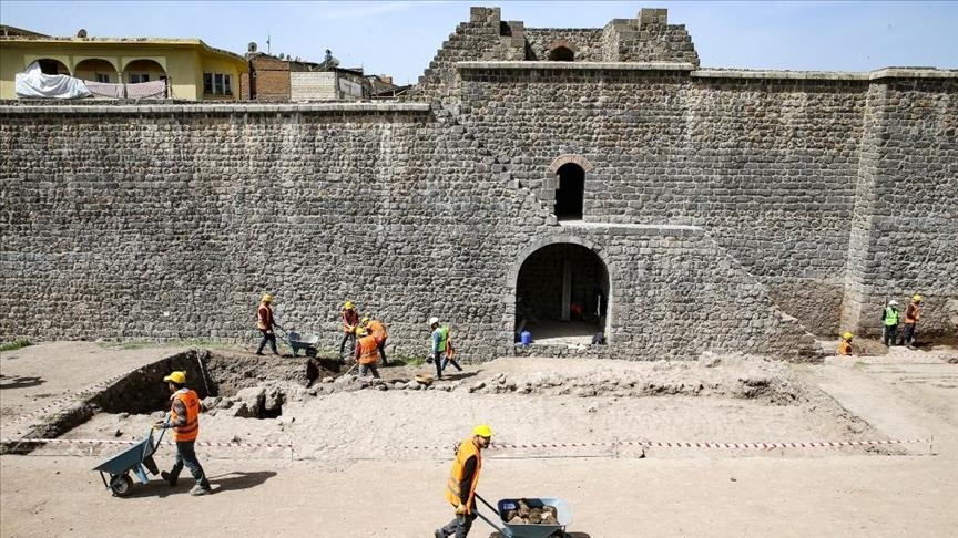
2,000-year-old Roman street unearthed in Turkey’s Diyarbakır
A 2,000-year-old street from the Roman period has been discovered in southeastern Turkey. The historic city of Diyarbakır, situated in southeastern Turkey, is home to innumerable ancient wonders and relics from throughout history.
Archaeological workers continue efforts to unearth a Roman-era street at the ancient Amida Höyük site in Diyarbakır, Turkey.
Currently, excavation to unearth the historical Roman street is being carried out in Amida Höyük, a mound known as the heart of Diyarbakır province while also being the historical Roman name of the city, along with Amed which was what it was called in the Assyrian period and modern-day Kurdish.
Professor Irfan Yıldız from Dicle University is leading the excavation amid strict measures against the coronavirus pandemic.
“Very interesting data continues to come from the west side of the mound we excavated. The street texture and structure of the period has started to emerge,” Yıldız said.
Yıldız noted that over the period of a year they expect to unearth many historical artefacts in the excavation.
Yildiz said by 2022 tourists using the Roman street will be able to visit the historical region of Içkale and be able to see streets from the Roman, Ottoman and Republican periods.
Diyarbakır was historically situated around a high plateau by the banks of the Tigris river on which stands the historic Diyarbakır Fortress.
Tigris was one half of the word “Mesopotamia” which translates to “between the rivers” in ancient Greek, a reference to the Tigris and Euphrates rivers that helped humanity thrive but also plunged it into some of the bloodiest wars of history.
Many small and large-scale states and empires were built upon the soil which offered plentiful natural resources essential for survival.
The city was conquered by Muslims in 639, only a few years following the conquest of Mecca in Saudi Arabia, which stands as the holiest city of Islam.
Today, Diyarbakır is home to the Hevsel Gardens which have been used for agricultural purposes for more than 8,000 years, the Great (Ulu) Mosque, one of the oldest mosques of Anatolia and the Malabadi bridge built during the Artuqid period in the 12th century.
Meanwhile, it is also home to the Hasuni Cave city where pre-historic people lived during the early years of Christianity, and the Zerzevan Castle, which is a Roman military facility containing the temple of Mithraism, a mysterious religion.