Turkey: 9-century old Harran Palace’s gate unearthed
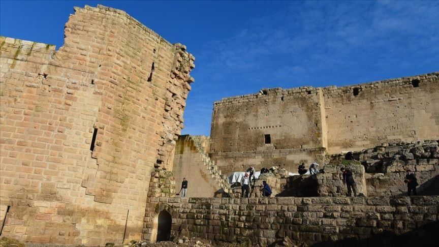
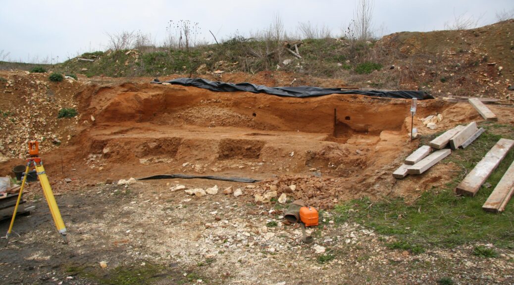
The main gate of the nine-century-old Harran Palace in an archaeological site in Turkey’s southeastern province of Şanlıurfa, one of the world’s oldest settlements on the UNESCO World Heritage Tentative List, has been unearthed.
The excavation work has been continuing for six years at the site located in the Harran district of Şanlıurfa, Mehmet Önal, the head of the excavation team and head of the Archeology Department at Harran University, told the state-run Anadolu Agency.
Harran, located 44 kilometers southeast of central Şanlıurfa near the Syrian border, was an important Mesopotamian trade center on a road running south to Nineveh in modern Iraq, while the site was constantly inhabited from 6,000 B.C. to the present and had also served as the capital of the Assyrians and Umayyads.
The excavation team had worked hard for two years to reveal the main gate of the historical palace, Önal said.
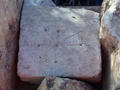
“We completely unearthed one of the two known gates of the historical Harran Palace. The gate, about 7 meters high, is made of basalt stones. Star motifs were also unearthed in our excavations near the ground.”
Önal underlined that the team had also unearthed other inscriptions written in Arabic on a basalt stone, adding that these inscriptions will contribute to trace the exact date of the historic construction.
He also said that the inscriptions and symbols on the stamp seals, rings, and arrowheads found in the excavations in the palace were also being analyzed by archaeologists.
Noting that a three-domed bathhouse in the Harran Palace has been discovered during the previous excavations, Onal said the bath with cooling, warming, and heating rooms was built in the 12th and 13th century and belonged to the Zengid dynasty and the Ayyubids period.
Stating that the palace, which dates back 900 years, has hundreds of rooms, he pointed out that the Harran Palace is one of the rare examples of palaces that have survived since the Middle Ages in the Middle Eastern countries.
Önal said that the year-long extension of the excavation period given by the Turkish Culture and Tourism Ministry well indicated the importance of this historical area.
If the excavations continue throughout the year, more historical artifacts could come to light, he added.
The first excavations in Harran began in 1950, and the site has been on UNESCO’s tentative list since 2000.
Harran is an important ancient city where trade routes from Iskenderun to Antakya (ancient Antioch) and Kargam were located, according to UNESCO’s website.
“The city is mentioned in the Holy Bible,” says the website. “It is important not only for having hosted the early civilizations, but it is the place where the first Islamic university was founded. The traditional civil architecture and mudbrick houses with conic roofs are unique.”
Possible Medieval Graffiti Found at Church Site in England
Medieval graffiti associated with repelling evil spirits has been discovered by HS2 archaeologists. A series of lines radiating from a drilled hole was discovered on two stones at the remains of a church in Buckinghamshire.
Historians believe such markings are witches’ marks, created to ward off evil spirits by trapping them in an endless line or maze.
They can also be interpreted as early sun dials.
Medieval graffiti associated with repelling evil spirits has been discovered by HS2 archaeologists
The location of one of the stones at the medieval church of St Mary’s, Stoke Mandeville, suggests the markings could have been created for protection.
The route of HS2 will go through the site of the 12th-century church, which was abandoned in 1866 when a new church was built closer to the village.
Work by archaeologists to dismantle and excavate the church will continue into next year and include the removal and reburial of bodies in graves.
HS2 Ltd lead archaeologist Michael Court said: “The archaeology work being undertaken as part of the HS2 project is allowing us to reveal years of heritage and British history and share it with the world.
“Discoveries such as these unusual markings have opened up discussions as to their purpose and usage, offering a fascinating insight into the past.”
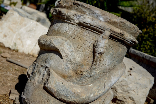
2,000-year-old snake-figure altar unearthed in the ancient city of Patara in southern Turkey
Daily Sabah reports that a marble altar encircled with a coiled snake carved in relief has been unearthed at the ancient city of Patara in southern Turkey.
The altar, which is believed to date back more than 2,000 years, was found during excavations conducted in an area close to the Roman baths and walls. It is decorated with a snake relief that appears to be winding around the stone.
Mustafa Koçak, an academic at the Department of archaeology at Antalya Bilim University and also the vice president of the excavation team in Patara, told reporters that the discovery highlights the first of its kind in the ancient Patara site.
Archaeologists discover 2,000-year-old snake altar in Turkey’s ancient city
“We found a snake-shaped altar for the first time in Patara. Similar discoveries were made in some ancient cities in Muğla but this is the first time such a discovery has been made in Patara.
This altar depicts the relations of people in Patara with the outside world,” Koçak said.
He added that residents of the area were polytheistic in ancient times and made offerings at the altar in a bid to appease the gods of the underworld. Furthermore, the snake motif on the altar is thought to be associated with the gods.
2 billion-year-old African nuclear reactor proves that Mother Nature still has a few tricks up her sleeve
In Gabon, Africa, the Oklo-Reactor is one of the most intriguing geologic formations on the Earth. In two billion-year-old rocks, natural fissile materials have sustained a slow nuclear fission reaction, as found in a modern nuclear reactor.
With a half-life of 700 million years, uranium-235 is a radioactive element. Traces of it are found in almost all rocks, especially magmatic rocks, and its decay is believed to be one of the sources of Earth’s inner heat. Because it decays over time at a constant rate, its concentration in the Earth’s crust is almost everywhere the same – except in Oklo.
A succession of sandstone and siltstone, the Oklo-Formation, was deposited by a large river two billion years ago. Microbial activity of the first lifeforms caused the element uranium, derived from weathered magmatic rocks, to become concentrated in certain layers of the sediments. Later tectonic movements buried the layers deep underground.
Simplified geology of the Oklo-Okèlobondo natural nuclear reactors.
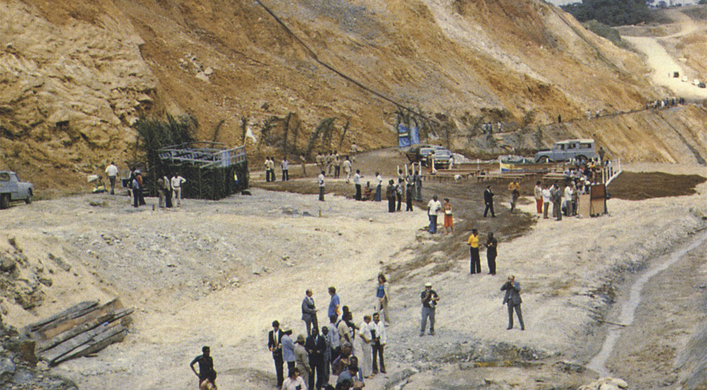
In 1972, chemical analysis showed an unusually low concentration of uranium-235 in the ore mined in the Oklo open pit mine. However, there were high concentrations of elements like cesium, curium, americium and even plutonium to be found. Such elements are formed today only in nuclear reactors, as the uranium decays during controlled nuclear fission.
When uranium-235 decays, it will emit three neutrons. If one of the emitted neutrons hits another uranium atom, this atom will also decay and a chain reaction will begin. In most rocks, there is either not enough uranium to sustain nuclear fission or it decays too fast to cause a chain reaction.
In the Oklo-reactor, two factors came together to sustain slow nuclear fission for hundreds of thousands of years. Weathering of magmatic rocks and bacterial activity concentrated the uranium enough to start a nuclear chain reaction.
Then the water that infiltrated the formation along faults slowed down the emitted neutrons enough to sustain slow and stable nuclear fission. As the uranium decays, it forms other radioactive elements fueling the reactor.
A worker stands next to a deposit of, among other things, naturally depleted uranium.
Over time the Oklo-reactor has produced large quantities of toxic plutonium and cesium-isotopes, which have since decayed into stable and harmless barium. During this process, however, no harmful radioactivity has leaked into the environment.
As the planet warms due to our carbon emissions, burning oil and coal is no longer a sustainable way to meet humanity’s hunger for energy. Many experts believe that nuclear energy could be a temporary solution until renewable energy sources are ready to meet the demand.
Unfortunately, nuclear energy comes with radioactive waste. A permanent repository for nuclear waste must contain toxic elements and radioactivity for at least 100,000 years. The problem is that we don’t know what materials to use for the containers to store the waste.
Steel will rust, concrete can leak and even glass is damaged by the emitted radiation. By studying the Oklo-reactor, scientists hope to find a way to safely dispose of nuclear waste as produced by modern reactors.
Research by a team of scientists of the US Naval Research Laboratory in Washington D. C. and published in the journal PNAS has investigated how the Oklo-reactor was able to work so long and yet not pollute the environment.
In rocks recovered from the Oklo mine, barium (the ‘trace’ left by the former radioactive elements) is not found evenly distributed but rather found in nests surrounded by a thin layer of ruthenium-compounds.
One of the Oklo nuclear reactors. Doesn’t look like much, eh?
Native ruthenium is a rare and inert metal often associated with ore of other elements. The scientists believe that the radioactive plutonium and cesium were encapsulated and safely isolated from the environment by a shell of ruthenium-compounds. If so, containers made of ruthenium alloys could be used to safely store radioactive waste for a very long time.
As the Oklo-reactor demonstrates, the ruthenium-compounds remain stable even if exposed to radioactivity and corrosion by water over vast geological periods.
New Study Redates Two Lower Paleolithic Sites in France
A publication in the journal Quaternary International led by Dr Mathieu Duval, Ramón y Cajal Research Fellow at the Centro Nacional de Investigación Sobre la Evolución Humana (CENIEH), is based on the use of an unprecedented combination of three different dating techniques, namely Electron Spin Resonance (ESR), Luminescence and Palaeomagnetism, to date two Lower Palaeolithic sites in France.
“The initial purpose of this study was to refine the chronology of these two sites, which are amongst the oldest evidence of the human presence in Western Europe, north of the 45°N latitude, before 500,000 years ago”, says Dr Duval.
“They were previously dated using one method only, and we now provide an independent age assessment, based on a multi-technique approach that enables to build a robust chronological framework.”
The two archaeological sites have delivered lithic tools that are typical of the Lower Palaeolithic, the oldest cultural period identified in Europe. The first one, Lunery-la Terre-des-Sablons, provided an Oldowan lithic industry similar to that found at other sites such as Atapuerca Gran Dolina, Sima del Elefante, Barranco León or Fuente Nueva-3 (Spain).
Initially dated to about 1.1 million years, the new study indicated a more complex site formation process than thought earlier, and a minimum age of 710,000 years is now proposed for the lithic tools.
In contrast, the new age results obtained for the second site, Brinay-la Noira, are in excellent agreement with those obtained previously. They confirm the age of the lithic industry to around 650,000 years, making the site one of the oldest Acheulean site in Western Europe.
“Nowadays, the number of old archaeological sites in Western Europe is still very limited, which is why it essential to obtain at least an accurate dating for those that have been found and excavated so far.
These new dating results will undoubtedly contribute to improving our understanding of the timing of the early human settlements in Western Europe”, concludes Prof. Josep M. Parés, co-author of the work and Head of the Geochronology and Geology Programme at CENIEH.
This work is the result of an international scientific collaboration involving researchers from various prestigious institutions such as the CENIEH (Spain), Museum National d’Histoire Naturelle (France) and University of Adelaide (Australia).
Background
The Geochronology and Geology Programme at CENIEH, Spain, hosts a unique combination of world-class facilities and international researchers fully dedicated to Human Evolution.
One of the main research lines of the program consists in refining the chronology of the early human occupations in the Mediterranean area, with a special emphasis on the combination of different dating methods in order to obtain more robust chronologies.
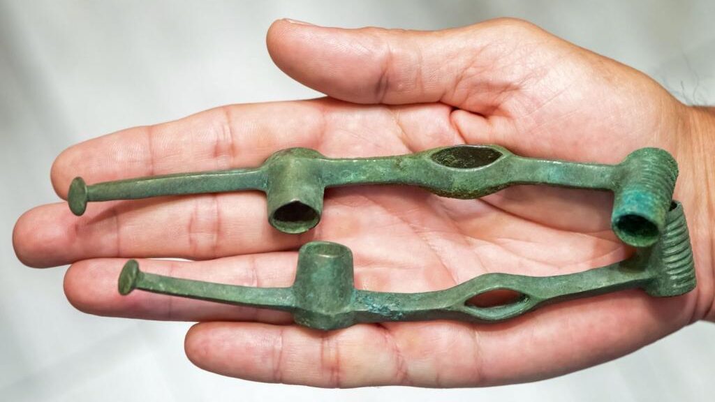
2,500-Year-Old Iron Age horse harness found by accident is oldest in CEE, say, archaeologists
Science in Poland reports that some 150 decorative bronze pieces of a 2,500-year-old horse’s bridle were discovered in north-central Poland.
The pieces, which resemble those made by the Scythians, who lived to the north, had been wrapped in leaves and placed in a leather bag. “This secured deposit had been buried on a sandy hill near the bank of the Vistula,” said Jacek Gackowski of the Nicolaus Copernicus University.
After searching a nearby hill, he had returned to the meeting point of the archaeologists, when his metal detector, which was still turned on, began beeping.
The researchers contacted Toruń Provincial Office for Monument Protection when they decided that they might have found something of historical interest that they discovered more than 150 large and smaller bronze pieces which made up a large part of a bridle.
The items were wrapped in leaves, analysis of which reveals they were probably burdock, and the bundles had been placed in a leather bag; its remains are also visible on the harness parts.
Dr Jacek Gackowski from the Institute of Archaeology of the Nicolaus Copernicus University in Toruń: “This is the first find of this type in Central and Eastern Europe.
“This secured deposit had been buried on a sandy hill near the bank of the Vistula. It can be assumed that someone who hid these valuable items planned their subsequent extraction.
“The preserved artefacts indicate that the bridle was very decorative, as evidenced also by the numerous tubular and ring-shaped harness parts made of sheet metal and wire.
‘It is an almost complete horse bridle. The only thing missing is a bit, the part inserted into the horse’s mouth; it was used to send signals and guide the animal.”
He added that the style of the harness can be traced back to the far north infiltration of nomads, possibly Scythians, in the environment of the Lusatian culture. This most likely took place in the early Iron Age (6th century BC).
He said: “Remember that the remains of Scythian weapons and ornaments are known from the area of Kujawy and the south-western edge of the Chełmno Land. (…) Perhaps the treasure from Cierpice is a trace of dramatic events that could have occurred between the local population and culturally alien, horse-riding visitors from far away.”
In addition, archaeologists also found a locally-made socketed axe inside the leather bag.
Wojciech Sosnowski from the Provincial Office for Monument Protection in Toruń said that “at the moment, it is difficult to answer” why or how the axe was in the bag, adding: “An interdisciplinary research team will be established to solve all the mysteries related to the discovered treasure. It will include pre-historians, archaeometallurgists, conservators and representatives of the natural sciences.
“Samples will be taken and their analysis will allow, among other things, to determine the exact time when the treasure was buried.”
But he suggested that the person who buried the metal parts treated them as a raw material for further remelting. During this period, metals were considered very valuable and they were in short supply. The whole treasure weighs about 1 kg; the parts are light so as not to constrain and unnecessarily burden the horse, he said.
The Kaibab Plateau located in central Northern Arizona showcases a mysterious majestic city epic in size and proportion. While this city is officially referred to as a series of natural “Grand Canyon Monuments”, they are in fact precisely arranged pyramids towers and temples aligned to both the star and nebula pattern of ORION “The Hunter” and Pleiades constellations.
This appears to be a great city of a “lost” continent hidden in plain sight. There is neither folklore nor definition of it, although, Egyptian and Asian artifacts have been found.
Some of which swiped under the guidance of the Smithsonian Institute. If giant Nephilim skeletons were recovered, only the inner circles of the secret societies would know. The city is veiled in secrecy using deceptive language and tactics as a device for keeping the general population from understanding what the “Monuments of the Grand Canyon” truly are.
The topographical map of the National Park shows the high elevations of the monuments named after Egyptian and Asian Gods, etc.
A water sculpted canyon. Now that’s a ‘wonder’
The Monuments embedded within this great chasm is now confirmed to be a set of pyramids and structures defining a city of such enormous expanse that it very well could have been the metropolis of a lost continent populated with an antediluvian civilization. The antediluvian period begins with the Creation according to Genesis and ends with the destruction of all life on the earth except those saved with Noah in the Ark, and possibly disguised by the knowledge of the secret societies.
This city is a remnant of an ancient continent. It remains a mystery, however, the notion that it may even be infamous and highly sought after the lost continent of Atlantis is certainly plausible, it most likely is a companion pyramid array not unlike what would be found at the 19th leyline node, Atlantis, or the first node where the great pyramid Khufu stands exactly in the centre of the earth plane.
The hypothetical “Lost land” known as Lemuria might be considered by some, however, the legend and theories regarding Lemuria are more rooted in fictional hearsay than would lend more research for revival here with the identifying location as a reasonable manner the city within the canyon. The opposite may be true as further research takes place in which more may be revealed.
West Java, Indonesia perhaps
In the case of the sunken continent of Atlantis, it has always been thought of as an entire parcel of land surrounded by the waters of the Atlantic Ocean. The world-renowned cosmic channel, Edgar Cayce, verifies this although sceptics and others have postulated otherwise.
One professor, the late professor Arysio Nunes dos Santos, suggests Atlantis is in the location of the newly discovered pyramids found on West Java, Indonesia. Other volumes of published materials produce mostly conjecture, however, without an honest look at real evidence. They are valiant efforts.
The likely truth is that a world flood did occur covering much of the topography of the land and seas in which when had mostly receded, Atlantis remained submerged and not sunken at all. Or, the waters that were added to the downpour of the waters from above creating the destructive force killing all life and devastating all constructs on the surface created a ‘sinkhole’ effect in which the mythical place we call Atlantis did actually sink.
There is a proof now that pyramids do exist in the Southwest United States. They do reside under an ancient seabed which establishes that they are all coordinated and line up precisely with the major stars and nebulae of the constellation Orion “The Hunter”. The same has been established with the great pyramids of Giza in Egypt. The difference is that all of the stars and nebulae of Orion match with the canyon Monuments with clarity.
The Grand Canyon with all its pristine beauty is neither naturally formed or organic in nature. This unique area at the Kaibab Plateau is indeed a widespread chasm that could not have possibly been carved out by a tumultuous river which is narrow by comparison. A simple observation of the angularity about the Monuments shows that they are devoid of sweeping curves on the stones. This logically demonstrates that water did not spend enough time sculpting smooth forms.
Is the historic record genuine?
If geologists, archaeologists, scientists of all areas agree that the mighty Colorado River in it’s strange but rather small in scale and configuration could form this canyon, then perhaps our geological historians are accurate. I agree that a river or series of them did cut vast areas of earth from the South to North rim and then on over to Nevada and down. I’ll buy the argument that simply because these are ancient structures built of hardened earth and that the soft was swept away over millions of years and so on has to be that simply because I’m showing proof these are aligned to stars.
I would have to also think that if we washed away all of the soft earth over the entire continent that we’d find the whole of our astrological system in the form of intelligently crafted pointed buildings. After all, what else other than a globe besieged by water could bury so many archaeological finds throughout the world? I do not believe that over time earthly renovations due to tropical storms, even hurricanes, tsunamis, and volcanic activity could have buried modern in ancient times cities.
There is evidence that mighty pointed formations are found in other canyons. And, they are also stepped and blocked. Blocks are angled at 90 degrees and these angles are seen in the Grand Canyon almost every yard of the way. This means that rivers did etch away doing its beautiful carving of the Great Deluge sediment from the original engineering constructs.
If this is absurd, then there’s room to suggest that there may have been an alien intentioned agenda at large. Perhaps there were massive ore harvesting projects aimed at stealing enormous caches of treasure, in particular, GOLD. A mining project as large as Massachusetts perhaps.
An Alien archaeological dig
If the historical record is wrong that a river the width of the Colorado River could have snaked its way completely and everywhere around these monumental features, then there must be an explanation as to how this massive ditch be created. The river could have been wider or several as opposed to the single one we know today, however, if there is an explanation, it would have to be alien inspired.
This great gorge may actually be an ancient geoforming project on the largest of scales known on planet Earth. The intent, obviously Alien, was to remove the softer ancient seabed sediment and earth that had engulfed the city. This occurred most likely during the flooding of the planet as told in Biblical terms regarding Noah and the story of the Ark.
This city then became an unearthed treasure trove find by off-world interests. Perhaps those who competed, or even battled against the Anunnaki of Nibiru (Planet X). Their goal perhaps for conquest over the megalithic cache of gold – primarily – that to a person living today be incomprehensibly vast. For you see, the Monuments of the Grand Canyon may have been completely covered – layered – in gold. The temples were filled as well as ordained with silver, gold and platinum. Aluminium was also a valuable metal. This city could very well have had the appearance of a scaled-up, way up, version of the most ornate crown of jewellery.
Why was this alien archaeological dig conducted?
A scene In the 2011 film Cowboys and Aliens in which an alien spaceship arrives in Arizona in 1873 to mine for gold, a unique technology was used. The scene to the right depicts unique liquid streaming of gold as it rises as if drippings along a string up from the depth of the canyon into the alien ship.
To plunder and harvest gold of coarse. A project of this size had to have been to liberate the treasure from a whole city the size of, well, the Grand Canyon. Alien ‘Pirates’! Once the city was revealed, some incredible technology had to have been implemented to strip the precious metals from the massive Monuments. Perhaps a complex smelting process was used. The gold then off-loaded to other locations on Earth or off-world. Hollywood, as always, gives us a “tell” in an alien-related film in which an unusual method is shown how an alien intelligence extracts gold from the earth. This is relevant for the reason it is taking place in Arizona, the location of the mining, or excavation, is in a canyon, and that it is being conducted by aliens. Furthermore, a war is taking place all because of gold.
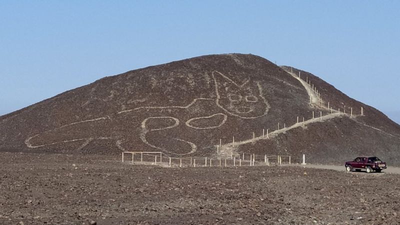
Large 2,000-year-old cat discovered in Peru’s Nazca lines
Southern Peru’s dunes, carved with the geoglyphs of a hummingbird, a monkey and an orca-a figure some would dearly love to believe is an astronaut – have now revealed the form of an enormous cat lounging across a desert hillside.
During the work to increase access to one of the hills that offers a natural vantage point from which many of the designs can be seen, the Feline Nazca line was found, which dates from 200 to 100BC.
A Unesco world heritage site since 1994, the Nazca Lines, which are made up of hundreds of geometric and zoomorphic images, were created by removing rocks and earth to reveal the contrasting materials below. They lie 250 miles (400km) south of Lima and cover about 450 sq km (175 sq miles) of Peru’s arid coastal plain.
This handout photo provided by Peru’s Ministry of Culture-Nasca-Palpa shows the figure of a feline on a hillside in Nazca, Peru, Friday,
“The figure was scarcely visible and was about to disappear because it’s situated on quite a steep slope that’s prone to the effects of natural erosion,” Peru’s culture ministry said in a statement this week.
“Over the past week, the geoglyph was cleaned and conserved, and shows a feline figure in profile, with its head facing the front.” It said the cat was 37 metres long, with well-defined lines that varied in width between 30cm and 40cm.
“It’s quite striking that we’re still finding new figures, but we also know that there are more to be found,” Johny Isla, Peru’s chief archaeologist for the lines, told the Spanish news agency Efe.
“Over the past few years, the use of drones has allowed us to take images of hillsides.”
Isla said between 80 and 100 new figures had emerged over recent years in the Nazca and Palpa valleys, all of which predated the Nazca culture (AD200-700). “These are smaller in size, drawn on to hillsides, and clearly belong to an earlier tradition.”
The archaeologist said the cat had been put out during the late Paracas era, which ran from 500BC to AD200.
“We know that from comparing iconographies,” said Isla. “Paracas textiles, for example, show birds, cats and people that are easily comparable to these geoglyphs.”