High-Tech Tools Offer a Glimpse Into a Medieval Reliquary
An interdisciplinary research team led by the Leibniz Center for Archeology (LEIZA) has revealed the secret of a gold-plated pendant that was found in 2008 in a medieval rubbish pit in the old town of Mainz.
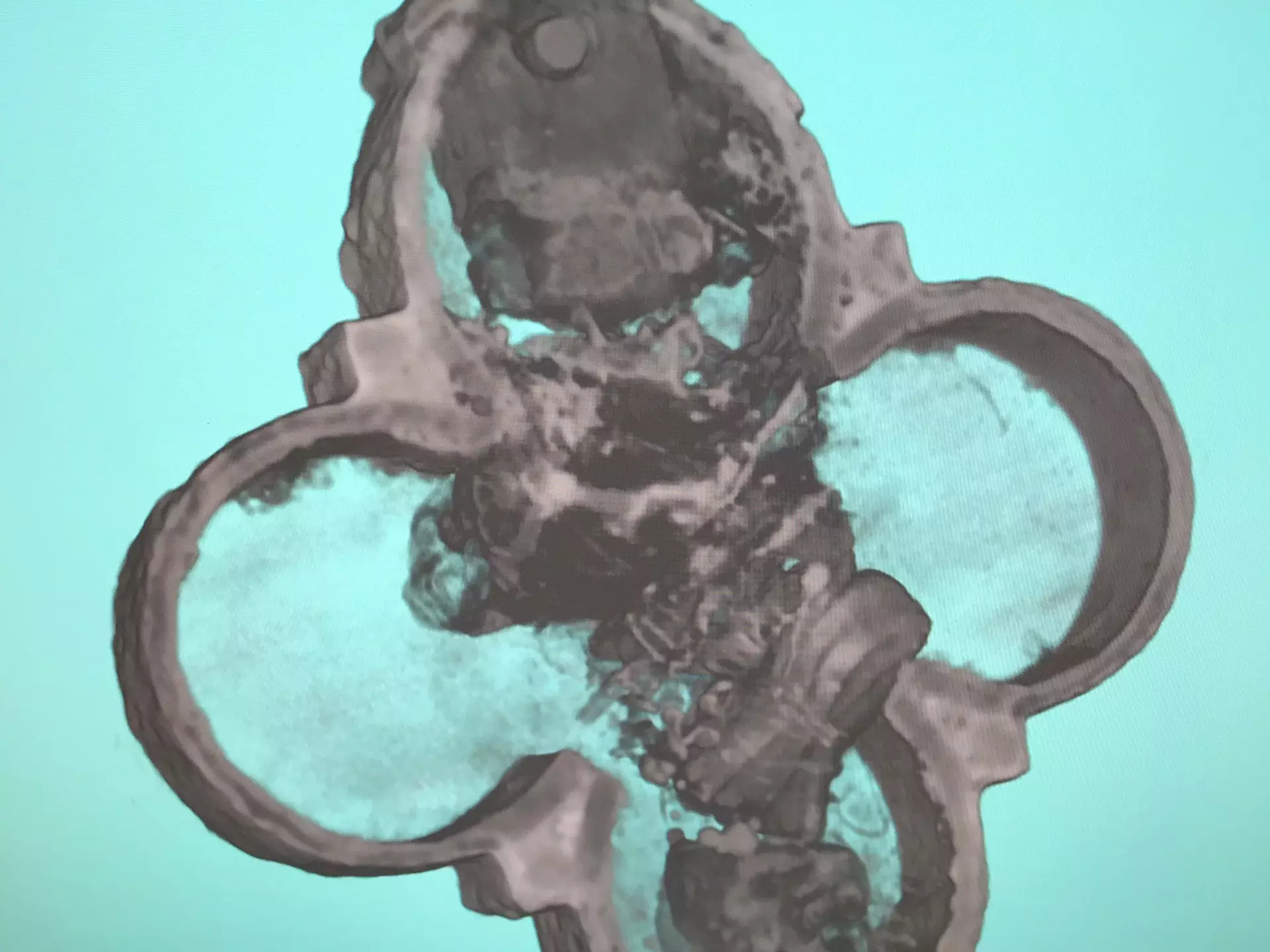
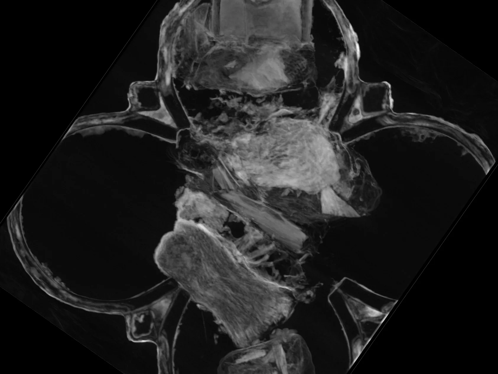
Thanks to non-destructive investigations at the research neutron source Heinz Maier-Leibnitz (FRM II) of the Technical University of Munich (TUM), the researchers were able to locate the smallest bone splinters inside the object, which are probably relics.
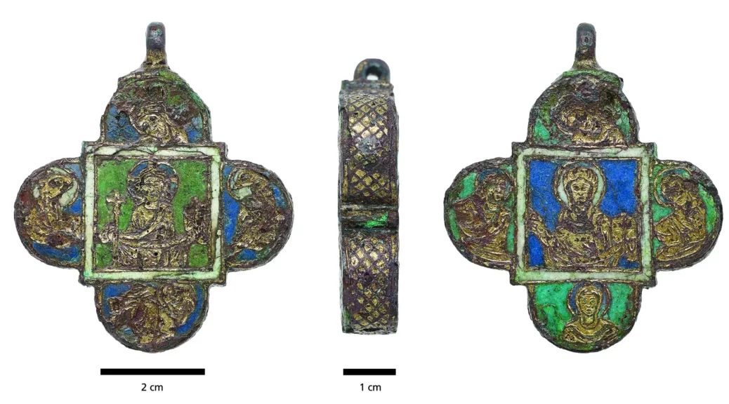
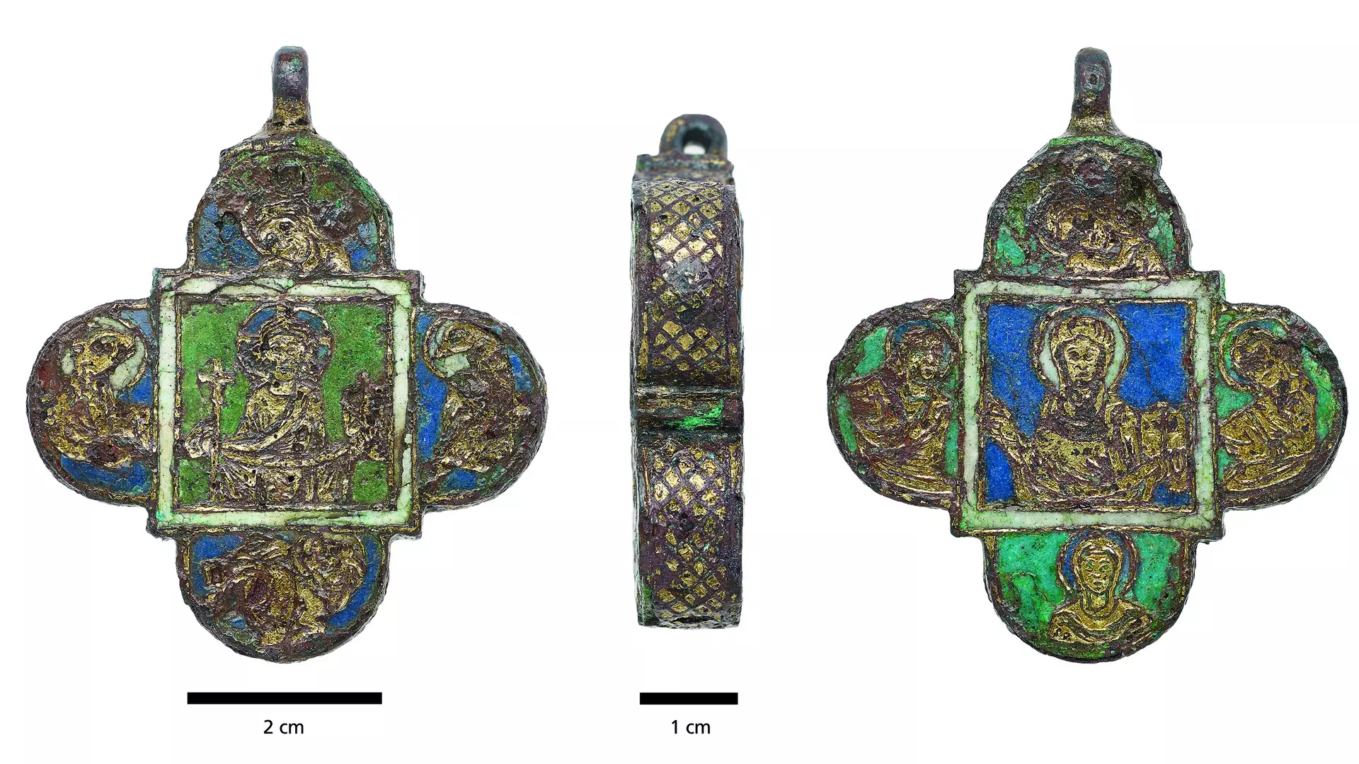
The restored reliquary. Outside it is decorated with images of Jesus and Mary.
Analysis of the tomography and Prompt Gamma Activation Analysis (PGAA) with neutrons revealed five individual packets made of silk and linen – bone splinters were packed in each. “Neutron non-destructive testing was particularly helpful because we couldn’t just open the trailer and look inside.
The object and above all the locking mechanism are severely damaged by centuries of corrosion, and opening it would mean destroying it irrevocably,” explains restorer Matthias Heinzel from LEIZA.
During the restoration, Heinzel discovered a cord fragment in the suspension eyelet which, on closer examination, was identified as silk. “This is the first evidence that such pendants may have been worn around the neck on a silk cord.
Using neutron tomography at the TUM, we were also able to measure the thread thickness and thread spacing of the textiles on the inside,” adds the restorer.
Neutron analysis makes organic substances visible
In 500 hours of work, Heinzel freed the found object from corrosion deposits. Initial investigations showed that the pendant, which is about six centimeters high and wide and one centimeter thick, was probably a storage container for relics.
Since the organic content of the object was not recognizable on the first X-ray images, the investigation using neutrons from the FRM II was used: Dr. Burkhard Schillinger from TUM conducted the ANTARES instrument performed a neutron tomography, which made the individual textile packages with the bone splinters inside visible. Unlike X-rays, the neutrons can penetrate metals and make organic substances visible.
The researchers determined individual elements of the sample by using neutrons to excite them to emit characteristic gamma radiation during the PGAA.
“It is not possible to find out whether the bones belong to saints and which saints the bone splinters can be assigned to. A strip of parchment with the name of the saint is usually attached to a relic parcel. In this case, unfortunately, we cannot see it.
As an archaeological research institute of the Leibniz Association, we see it as our task to preserve the historical authenticity of the object for posterity in the best possible way and use the modern possibilities of non-destructive examination at the Technical University of Munich,” explains Heinzel.
Only three other reliquaries of this type, called phylactery, are known so far. Phylacterium translates from Greek as means of preservation or protection. Their owners wore them on their bodies, usually around their necks.
On the outside, the gilded copper pendant is enameled with images of Jesus, the four evangelists, Mary and four female saints.
The researchers date it to the late 12th century and assign it to a workshop in Hildesheim, Lower Saxony. The find is in the possession of the General Directorate of Cultural Heritage, Directorate of State Archeology Mainz and can be viewed until further notice in the medieval exhibition “AUREA MAGONTIA – Mainz in the Middle Ages” of the State Museum Mainz.
20,000-year-old cave painting ‘dots’ are the earliest written language, study claims. But not everyone agrees.
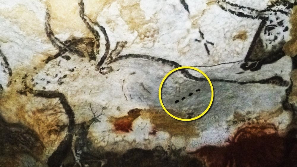
A 21,500-year-old cave painting depicting an aurochs, an extinct cattle species, in the Lascaux caves in France. Notice the four dots (within the digital yellow circle), which may have had a special meaning for ice age peoples.
At least 20,000 years ago, humans living in Europe created striking cave paintings of animals that they paired with curious signs: lines, dots and Y-shaped symbols. These marks, which are well known to researchers, might relate to the seasonal behavior of prey animals, making the signs the first known writing in the history of humankind, a new study claims.
Although Paleolithic cave art is better known for its graceful horses and ghostly handprints, there are thousands of nonfigurative or abstract marks that researchers have begun studying only in the past few decades. In a study published Jan. 5 in the Cambridge Archaeology Journal, a team of scholars suggests that these seemingly abstract dots and lines, when positioned near animal imagery, actually represent a sophisticated writing system that explains early humans’ understanding of the mating and birthing seasons of important local species.
Other researchers, however, are not convinced by the study’s interpretations of these human-made marks.
Melanie Chang, a paleoanthropologist at Portland State University who was not involved in the study, told Live Science in an email that she agrees with the researchers’ assessment that “Upper Palaeolithic people had the cognitive capacity to write and to keep records of the time.” However, she cautioned that the researchers’ “hypotheses are not well-supported by their results, and they also do not address alternative interpretations of the marks they analyzed.”
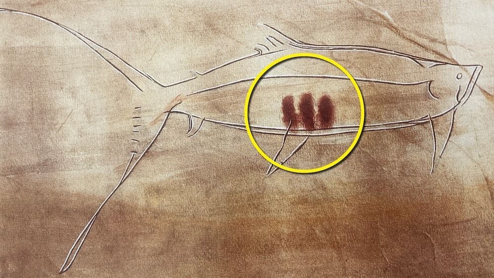
This image of an 17,000-year-old engraved salmon, from Pindal cave in Asturias, Spain, has three lines placed within.
What do the painted marks mean?
Early humans in Europe were hunter-gatherers who ate a lot of meat from species such as horses, deer and bison. When those animals came together seasonally in herds, they would have been vulnerable to slaughter by humans.
“It follows that knowledge of the timing of migrations, mating and birthing would be a central concern to Upper Paleolithic behaviour,” study first author Bennett Bacon, an independent researcher and furniture conservator based in London, and colleagues wrote in their study.
Looking at the total number of marks — either dots or lines — found in sequences across hundreds of caves, the researchers discovered that none of the series contained more than 13 marks, consistent with the 13 lunar months in each year.
“We hypothesize that sequences are conveying information about their associated animal taxa in units of months,” they wrote, noting that spring, “with its obvious signals of the end of winter and corresponding faunal migrations to breeding grounds, would have provided an obvious, if regionally differing, point of origin for the lunar calendar.”
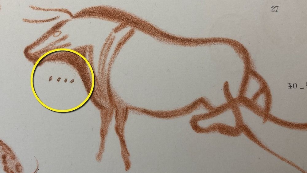
An annotated image of a roughly 23,000-year-old painting showing four dots associated with a red ochre drawing of an aurochs in La Pasiega cave in Cantabria, Spain.
The researchers’ statistical analysis of more than 800 sequences of marks associated with animals supports their idea — they found strong correlations between the number of marks and the lunar months in which the specific animal is known to mate.
Taking their hypothesis a step further, Bacon and colleagues focused on a Y-shaped sign that they think refers to a particular event in an animal’s life cycle. The similar statistical analysis supports their conclusion that the placement of the Y-shaped sign within a series of marks signals an animal species’ birthing season.
“The ability to assign abstract signs to phenomena in the world,” they wrote, “to record past events and predict future events, was a profound intellectual achievement.”
Writing or proto-writing?
But is this the earliest known writing? Bacon and colleagues demur, suggesting that “it is best described as a proto-writing system, an intermediary step between a simpler notation/convention and full-blown writing.”
April Nowell, a Paleolithic archaeologist at the University of Victoria in Canada who was not involved in this study, told Live Science by email that “any study that explores non-figurative signs in more detail is welcome, but I think there are a number of assumptions being made here that have yet to be proven.” Nowell questioned the Y sign, in particular. “The majority of animals considered in this study are quadrupeds, and humans normally squat giving birth,” she said. “If this sign is supposed to be iconic of the birth process, it is not obvious to me.”
Chang, the paleoanthropologist who is also an equestrian and horse owner, posed two alternative explanations for the Y sign. In some cases, it could represent the edge of the brachiocephalic muscle, a prominent landmark on a horse’s neck. “In other cases,” she said, “it is possible that what they recorded as Y’s represent what modern horsepeople refer to as ‘primitive markings’ such as leg bars that are associated with wild-type horse colors, or they may represent hair patterns, or other anatomical features.”
Study co-author Robert Kentridge, a professor in the Department of Psychology at Durham University in the U.K., told Live Science in an email that one of the strengths of their study is that they “have formally tested Ben [Bacon’s] hypotheses about the meaning of the Y-sign’s position in sequences of marks and the lengths of sequences of dots and lines and shown that these do convey meaning, indeed meaning that would be important in the lives of Palaeolithic hunters.”
In summarizing their conclusions, Bacon and colleagues wrote that they have “proposed the existence of a notational system associated with an unambiguous animal subject relating to biologically significant events” and that this allows them “for the first time to understand a Palaeolithic notational system in its entirety.”
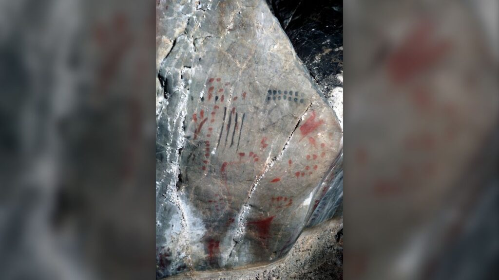
Nonfigurative signs dating to 15,000 years ago that hunter-gatherers drew in black manganese and red ochre in Niaux Cave in the French Pyrenees.
A decade ago, however, Nowell and then-graduate student Genevieve von Petzinger co-created a database of dozens of signs and repeating motifs from more than 200 caves in southern France and Spain. Von Petzinger’s thesis detailed patterns of cave wall symbols across time and space in order to better understand what these signs meant for ice age people.
“There are at least 32 different recurring signs,” Nowell explained. “The authors have chosen to study three of them in a very specific context.”
But the authors defended their decision to focus on the trio.
“It seemed sensible to focus first on the most common markings associated with figurative images,” study co-author Paul Pettitt, a professor of archaeology at Durham University, told Live Science in an email. “Simple dots and lines are by far the most common. Of the more elaborate signs, the Y sign is the most common.”
The researchers plan to expand on their work. “We are analyzing other signs,” Bacon told Live Science in an email. “Rather than searching for the meaning of individual signs, what we are looking for is the linguistic and cognitive bases that underpin the ‘writing’ system.”
Nowell agreed with the study authors that the symbols were likely not randomly chosen and that it is possible the lines and dots represent numbers. Even if the authors are correct, she noted, that leaves 90% of the signs without any known meaning.
“There is still a lot about graphic communication in the Paleolithic that we do not understand,” Nowell said.
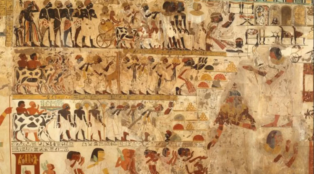
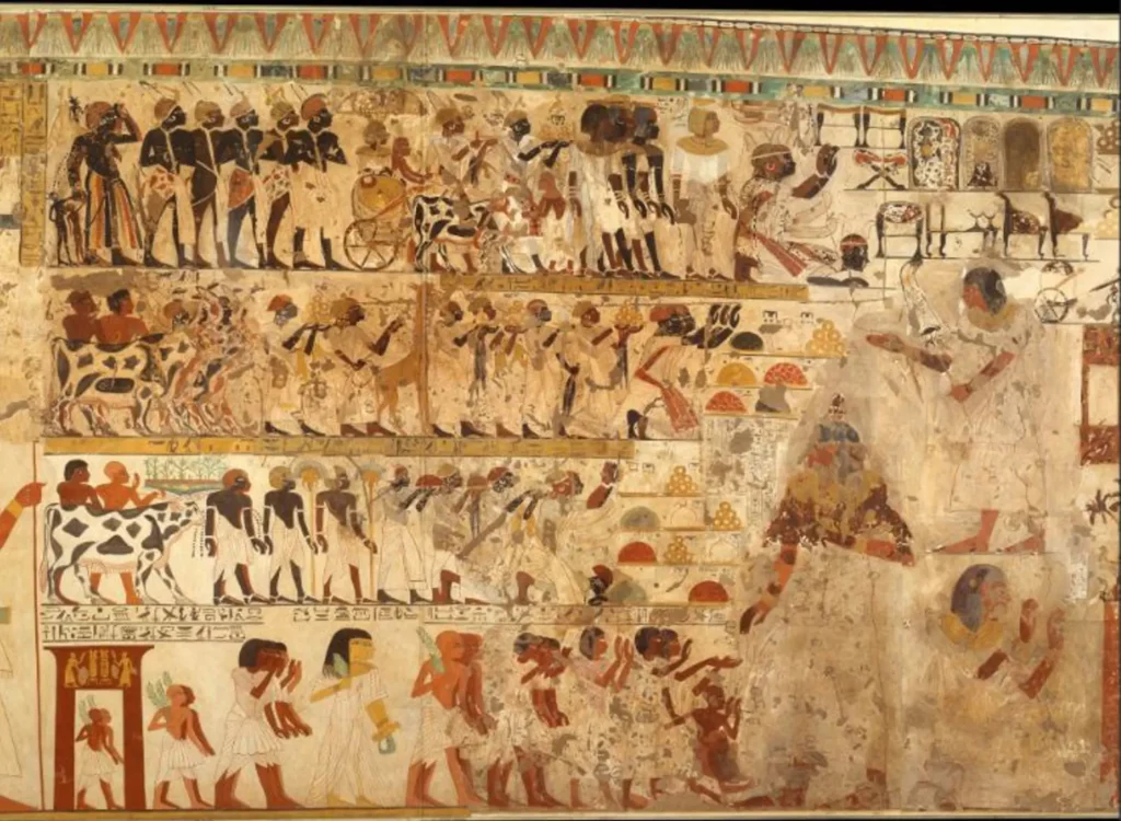
Discovery of 60 mummies in Egyptian city of Luxor points to elaborate burial ground
A wall drawing in the tomb of Amenhotep-Huy in Luxor.
A team of Spanish archaeologists have discovered tombs housing around 60 mummies in the ancient Egyptian city of Luxor, according to Spanish press reports.
The Spanish news agency Efe posted a video on YouTube, describing how the Spanish archaeological mission known as the Vizier Amenhotep Huy Project discovered the tombs late last year in the southern Egyptian city.
The mission was led by Francisco Martin-Valentin, director of the Madrid-based Institute of Ancient Egyptian Studies, and the institute’s co-director Teresa Bedman.
The Institute of Ancient Egyptian Studies also posted a corresponding article on Twitter from Efe.
Compartimos con vosotros una interesante entrevista realizada a nuestros directores, el Dr. Francisco Martín-Valentín y Teresa Bedman, en donde hablaron sobre el «Proyecto Visir Amen-Hotep Huy».
Martin-Valentin says that the two tombs were built after the 18th dynasty (1550-1292 BC) and are linked to Amenhotep-Huy who served as vizier (high-ranking official) under pharaoh Amenhotep III.
Two chambers connect the newly discovered tombs to the vizier’s tomb, a chapel comprising 30 columns.
Martin-Valentin tells The Art Newspaper: “In the excavations of two secondary tombs existing in the courtyard of the main tomb of the Vizier Amen-Hotep Huy (Asasif nº -28) have been found stripped mummies—more or less complete—and parts of mummies, which testify after the examination of our anthropologists to belong to about 60 individuals, originally buried in these tombs.”
Martin-Valentin adds that the new findings are “evidence that the vizier’s tomb at some point became a necropolis”. He tells us: “From the archaeological context we can affirm that the individuals found, belong to family groups of, or linked to, the medium-high clergy of Amun of Karnak.”
Items from the vizier’s tomb, including a sarcophagus adorned with the god Amun, are currently on display in an exhibition at the Luxor Museum.
Martin-Valentin says that the archaeological mission will resume at the end of September, when the vizier’s chapel will be restored with the reconstruction of six columns.
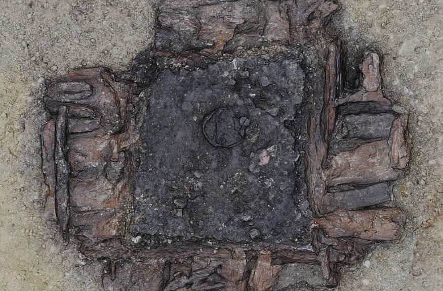
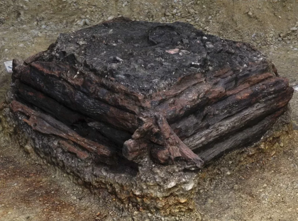
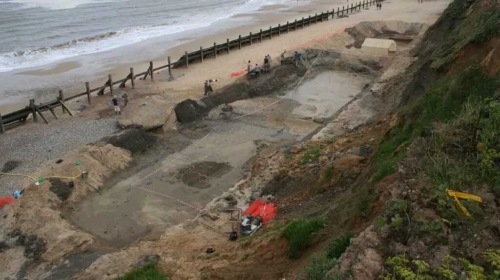
3000 years old wooden wishing well discovered in Germany
In the town of Germering, in the Germany state of Bavaria, archaeologists have unearthed the remains of a well-preserved Bronze Age wooden well filled with ritual deposits.
People may have sunk jewelry and ceramics as offerings in the special water spring, similar to how coins are still thrown into so-called wishing wells today, according to the archaeologists.
The area of today’s town of Germering in Upper Bavaria was a settlement area early on. Numerous finds from prehistory and early history bear witness to this.
Many new ones have been added since the beginning of 2021: In the run-up to construction work, numerous traces of settlements from the Bronze Age to the early Middle Ages were discovered on an excavation area of around seven hectares.
This also includes the remains of wells that were used by people of different eras to supply water. But one of the wells discovered on the site differed significantly from the others, reports the Bavarian State Office for the Preservation of Monuments (BlfD).
This wooden water point is dated to be more than 3000 years old and, at around five meters (16.4 feet), reached particularly deep into the ground compared to others.
“It is extremely rare for a well to survive more than 3,000 years so well. Its wooden walls have been completely preserved at the bottom and are still partly damp from the groundwater. This also explains the good condition of the finds made from organic materials, which are now being examined more closely. We hope this will provide us with more information about the everyday life of the settlers of the time,” adds Dr. Jochen Haberstroh, a responsible archaeologist at the Bavarian State Office for the Preservation of Monuments.
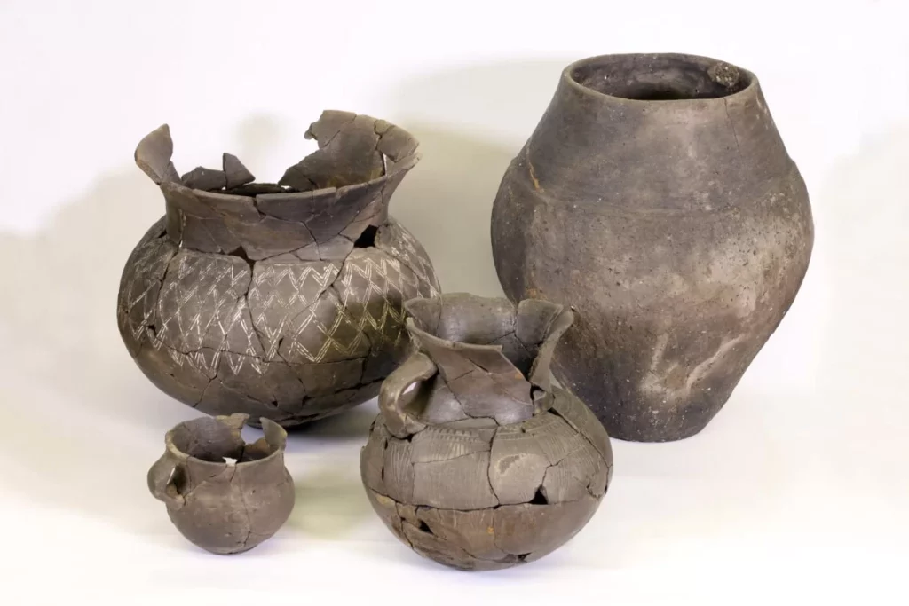
Medieval pottery from well fill.
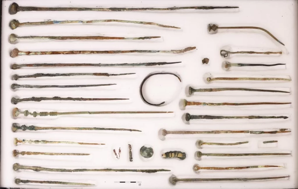
The team of archaeologists discovered in what was once the base of the fountain: 26 bronze clothing pins, a bracelet, two metal spirals, a mounted animal tooth, amber beads and more than 70 ceramic vessels.
The archaeologists emphasize that this filling makes this well fundamentally different from the others on the excavation site.
These expensive items, which were typically discovered in Middle Bronze Age graves, were not items for everyday use (1800-1200 B.C.). The state they were in when discovered at the bottom of the well suggests they were carefully lowered into the water rather than dropped or thrown.
“Even today, fountains have something magical about them for many people. They drop coins in the hope that their wishes will be granted. We cannot exactly explain what motives our ancestors 3000 years ago made to offer jewelry and other valuable gifts. But it can be assumed that they were intended as sacrifices for a good harvest,” explains Mathias Pfeil from the BlfD.
Among other things, the archaeologists discovered numerous bronze clothing pins at the bottom of the well.
There may also be a clue in the unusual features of the well: “The depth of this well shows that it was used at a time when the groundwater level had dropped considerably, which indicates a long drought and certainly poor harvest yields.
One can possibly see a reason why the people who lived here at that time sacrificed part of their possessions to their gods in this well,” says Marcus Guckenbiehl, city archaeologist and archivist of Germering.
Archaeologists have been working in advance of construction work for a letter distribution center on the site where the well has now been discovered since the beginning of 2021.
The excavations are among the largest area excavations in Bavaria this year. In the meantime, scientists have documented approximately 13,500 archaeological finds, primarily from the Bronze Age and early Middle Ages.
Some of the discoveries are currently being examined and conserved at the Bavarian State Office for Monument Preservation.
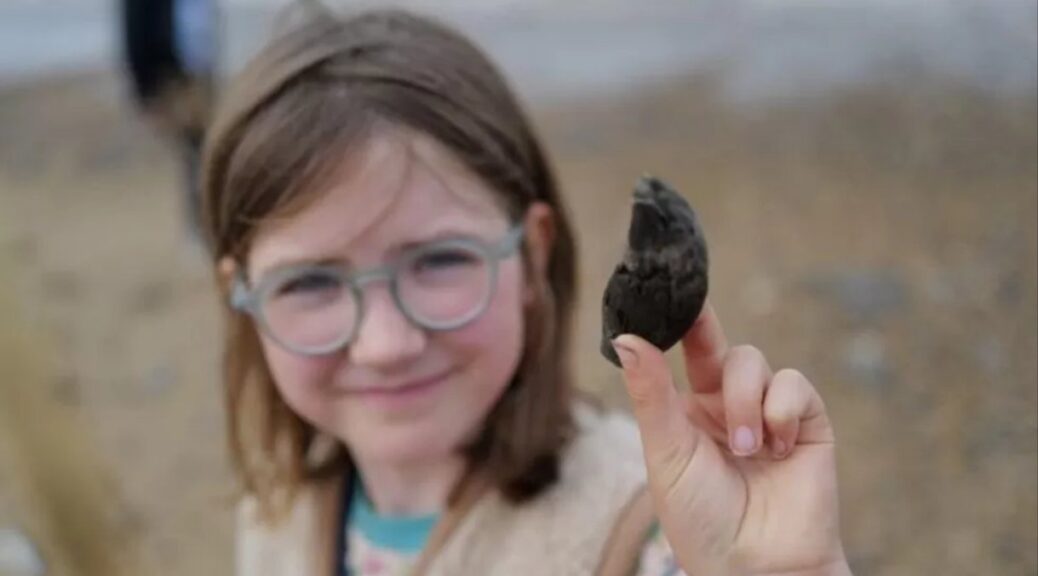
A Little Girl From London Finds a 700,000-Year-old Ancient Bear Tooth
Eagle-eyed Etta spotted the bear tooth on a family holiday – and experts were blown away by the discovery. BBC
Etta, from Hackney in London, made her discovery while on a family holiday on 22 July on Norfolk beach at West Runton.
While she was looking down she found something that she thought it was a fossilised bit of wood so she put it in her pocket, and when they got back to the car park they showed it to a fossil expert and she fell off her chair.
Etta initially thought the tooth was a piece of ancient wood, but it has since been confirmed as a bear’s tooth. BBC
“She said, ‘People search for 20 years and don’t find anything this good’ and told them it was a bear tooth.”
The nine-year-old, and her sisters aged seven and five, “really got into fossils” after attending a Norfolk Wildlife Trust fossil hunting course earlier in the year, their mother Thea Ferner explained.
Etta has loaned the tooth, which is about 9cm long (3in) from tip to root, to Norfolk Museums Service geologist David Waterhouse after meeting him at a fossil identification event at Cromer Museum.
About 1km (0.6 miles) of West Runton beach has been excavated by Norfolk Museums Service experts. BBC
“To find a perfect massive bear canine is a first for me in 16 years working here,” the senior curator of natural history said.
“We normally find lots of deer fossils, for example, but as you go up the food chain, you find fewer and fewer carnivores like the bear.”
He has identified it as an ancestor of the common brown bear.
Dr Waterhouse said “more extreme weather” is speeding up coastal erosion, which is “a double-edged sword – people’s homes and livelihoods are at risk, but it also means that amazing finds such as the Happisburgh footprints are being discovered”.
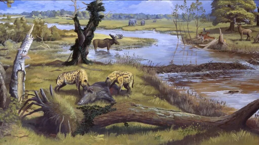
The Norfolk landscape 700,000 years ago would have had hyenas, lions, deer and mammoths. BBC
Norfolk’s Deep History Coast is a 22-mile (35km) stretch of coastline between Weybourne and Cart Gap.
Some of the more spectacular discoveries include the oldest archaeological site in northern Europe at Happisburgh, where 800,000-year-old human footprints were revealed in 2013. West Runton is also home to the oldest and largest fossilised mammoth ever found in the UK.
They are being unearthed in the Cromer Forest Bed geological layer, which at West Runton is 600,000 to 700,000 years old, said Dr Waterhouse.
The discoveries have pushed back archaeologists’ understanding of life by hundreds of thousands of years – and they have kept coming over the past 10 years, Dr Waterhouse explained.
These revealed the climate would have been like modern Poland’s, with similar summers but much colder winters than today.
About 1km (0.6 miles) of West Runton beach has been excavated by Norfolk Museums Service experts. BBC
“All these little nuances are building up to this rich picture of what animals and plants were thriving 700,000 years ago,” he said.
The earliest humans were Homo antecessor or Pioneer Man and they migrated across a landmass known as Dogger Land, which joined the British coast to present-day Germany and the Netherlands.
Dr Waterhouse said humans were still “a rare species… but everything was just right in Norfolk” for them, from wildfowl, game, shellfish “and crucially flint” to turn into sharp tools.
The nine-year-old said she planned to keep on fossil hunting.
A Mysterious Partially Submerged Structure in Ireland is a Prehistoric Tomb, New Research Finds
The Carraig á Mhaistin stone structure at Rostellan on the eastern shore of Cork Harbour, Ireland.
The tomb-like Carraig á Mhaistin stone structure, uncovered in Ireland’s Cork Harbour years ago, is now believed to be a megalithic dolmen.
Previously, experts have been unsure whether it was prehistoric or a 19th-century “folly.”
New research conducted by archaeologist Michael Gibbons indicated that the monument is in fact a megalithic dolmen.
A small chamber on the west side of an unknown cairn, a man-made stone stack marking a burial mound, measures 82 feet long by 15 feet wide. The cairn was previously concealed due to rising sea levels.
This is significant, as portal and court tombs “occasionally have intact long cairns which are both intended to provide structural support to the chamber itself, and to enhance visual presence in the landscape”, Gibbons told the Irish Examiner.
He believes that the cairn could extend well below the surface, “partially entombed in estuarine mud”.
It is unclear exactly when sea levels in the area rose, but they are believed to have been stable for the last 2,000 years.
There is only one other intertidal portal tomb on the island, and the Carraig á Mhaistin dolmen is one of three intertidal tombs in the country.
Among Irish folklore, portal tombs or dolmens were often known as Diarmuid and Gráinne’s bed—a final resting place for the fugitive couple who were pursued by Gráinne’s husband Fionn mac Cumhaill.
Many of these structures were built close to the coast; however, due to movement in the Atlantic ocean, many have not survived, including Sherkin Island’s sole megalithic tomb on Slievemore townland.
The Carraig á Mhaistin has not been previously included in the state’s survey of megalithic tombs in Ireland, conducted Ruaidhrí de Valera and Seán Ó Nualláin more than forty years ago, due to doubt surrounding its age.
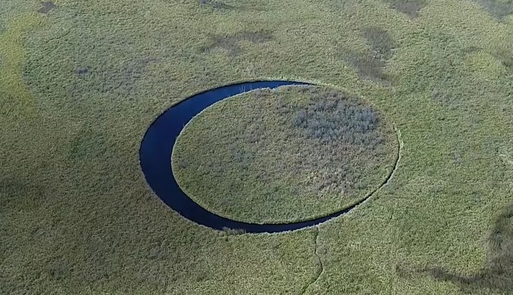
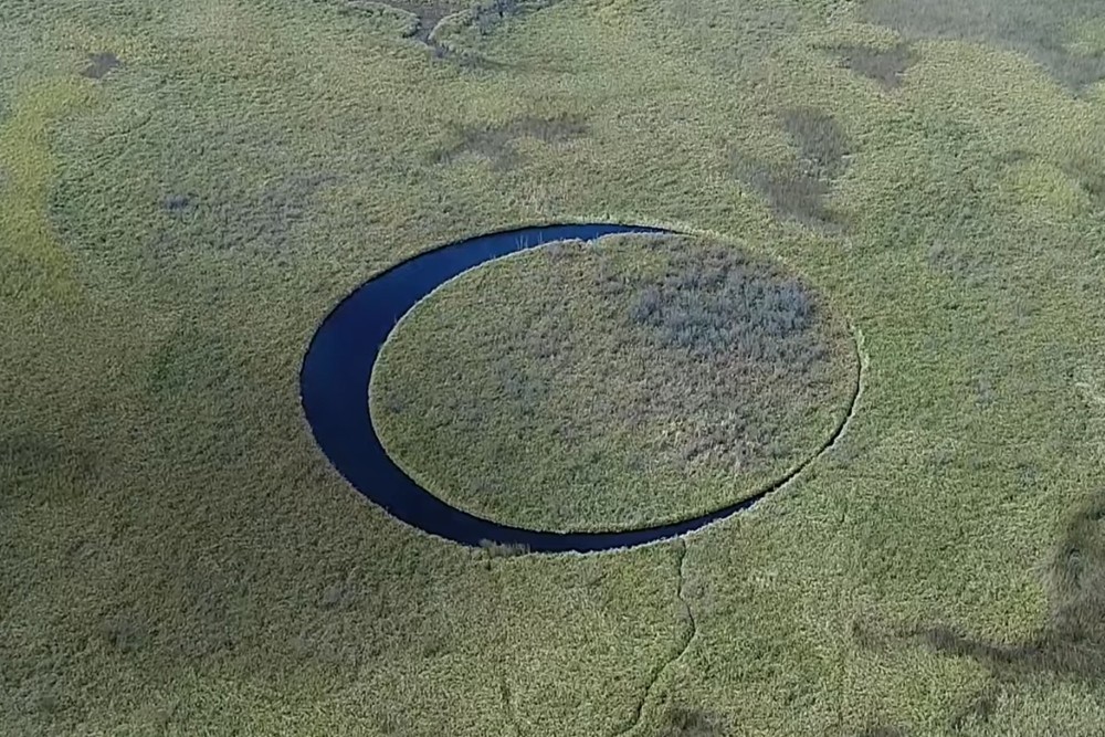
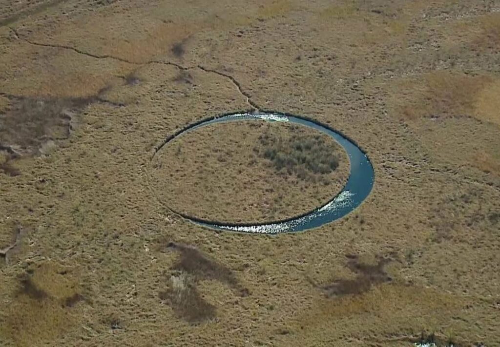
This Circular Island in Argentina Not Only Floats, But Also Rotates Constantly
South America’s second longest river, the Paraná, which has a length of 4,880 kilometers, flows through three countries: Brazil, Paraguay and Argentina. 4,880 kilometers is no short distance – it gives plenty of opportunities for discovering amazing things.
In the case of the Paraná, one of the most exciting discoveries was made at its delta: an island 120 meters in diameter, almost completely circular in shape, and floating freely on its axis.
So-called floating islands are found in many parts of the world, including Finland, Turkey, Italy, Serbia, the Danube Delta in Romania and Ukraine, Lake Titicaca on the border between Bolivia and Peru, Lake Loktak in India, and many other places. However, this Argentinean island stands out from the rest because of its shape and its continuous rotation.
Floating islands are usually based on large roots that have ended up in the water and on which some other aquatic plant starts to grow. Plants found along the shoreline of wetlands often spread inwards from the shore, to where their roots no longer reach the deeper parts of the lake or river. When this happens, they use the oxygen in their root mass as buoyancy and the surrounding vegetation as support to survive in the water.
However, occasional violent storms can tear away these floating islands of vegetation, which can then be carried back and forth across the lake by the wind. Usually, they find calm somewhere again along the shoreline or break up completely due to stronger winds.
In some cases, however, the floating islands may persist for longer periods. In the aforementioned Lake Titicaca, for example, a group of 120 islands has been taken by an indigenous tribe, the Uru, but these islands require constant maintenance to survive.
The unusual piece of land known only as “El Ojo” (Eye Island) was formed by some very special currents that keep the circular island in constant motion. As it collides with its surroundings, it repeatedly detaches the muddy bits that might have given it a rest.
The island itself was just recently discovered by Argentine filmmaker Sergio Neuspiller, who was looking for a location for one of his films about paranormal phenomena when he came across the island in the delta. He didn’t know at the time that the piece of land was spinning around slowly – he only found out when he returned to the site shortly afterwards and was surprised to see that the island had moved elsewhere in the meantime.
The recordings also prove that the island has been in the Paraná delta for almost 20 years, since 2003.
Neuspiller got preoccupied with the question of the rotating island later, around 2016, when he, together with an engineer from New York, started raising funds to find out what’s behind the phenomenon.
They wanted to collect 50,000 dollars to solve the mystery, but since not even a fifth of the amount came together, their investigation, which would have also covered the supernatural, was not completed. What a shame.
Study Investigates Source of Amazon’s “Dark Earth”
Indigenous people in the Amazon may have been deliberately creating fertile soil for farming for thousands of years.
Growing crops in the Amazon’s nutrient-poor dirt is tough. In a tradition that may be thousands of years old, indigenous Kuikuro people in Brazil overcome this issue by making their own fertile soil from ash, food scraps and controlled burns.
At archaeological sites across the Amazon River basin, mysterious patches of unusually fertile soil dot the landscape. Scientists have long debated the origin of this “dark earth,” which is darker in color than surrounding soils and richer in carbon.
Now, researchers have shown that indigenous Kuikuro people in southeastern Brazil intentionally create similar soil around their villages. The finding, presented December 16 at the American Geophysical Union meeting, adds evidence to the idea that long-ago Amazonians deliberately manufactured such soil too.
The fact that Kuikuro people make dark earth today is a “pretty strong argument” that people were also making it in the past, says Paul Baker, a geochemist at Duke University who was not involved in the research.
In doing so, these early inhabitants may have inadvertently stored massive quantities of carbon in the soil, says study presenter Taylor Perron, an earth scientist at MIT. The technique, he says, could provide a blueprint for developing methods of sustainably locking atmospheric carbon in tropical soils, helping fight climate change.
Indigenous people have altered the Amazon for thousands of years
The Western world has long viewed the Amazon as a vast wilderness that was relatively untouched before Europeans showed up. At the center of this argument is the idea that the Amazon’s soil, which is poor in nutrients like other tropical soils, precluded its inhabitants from developing agriculture at a scale required to support complex societies.
Most scientists today agree that the presence of dark earth near archaeological sites means that long-ago Amazonians used this soil to grow crops. But while some archaeologists argue that people purposely made the soil, others contend that dark earth was laid down through geologic processes.
Perron and colleagues reviewed interviews of Kuikuro people conducted by a Kuikuro filmmaker in 2018. Those conversations revealed that Kuikuro villagers actively make dark earth — eegepe in Kuikuro — using ash, food scraps and controlled burns.
“When you plant where there is no eegepe, the soil is weak,” explained elder Kanu Kuikuro in one of the interviews. “That is why we throw the ash, manioc peelings and manioc pulp.”
The researchers collected soil samples from around Kuikuro villages and archaeological sites in Brazil’s Xingu River basin. The team found “striking similarities” between dark earth samples from ancient and modern sites, Perron says. Both were far less acidic than surrounding soils — probably thanks to the neutralizing effect of ash — and contained higher levels of plant-friendly nutrients.
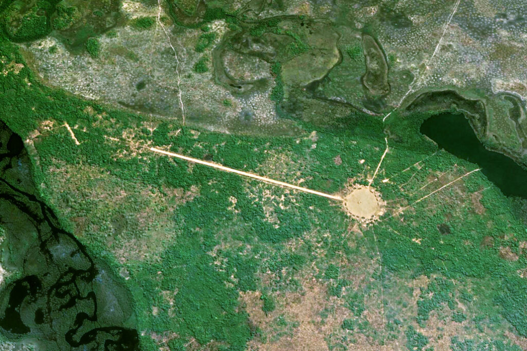
Soil that bears a striking resemblance to dark earth can be found in and around Kuikuro villages (one seen here from above) in southeastern Brazil.
Dark earth could store a lot of carbon in the Amazon
These analyses also revealed that dark earth holds twice the amount of carbon as surrounding soils on average. Infrared scans of the Xingu region suggest that the area is pockmarked with dark earth, and that as much as roughly 9 megatons of carbon — the annual carbon emissions of a small, industrialized country — may have gone unaccounted in the area, the researchers reported at the meeting.
This number, while preliminary, could inflate to roughly the annual carbon emissions of the United States when all dark earth across the Amazon is taken into consideration, Perron says.
Figuring out how much carbon is actually stored in the Amazon could help improve climate simulations. But the researchers’ estimates are a “huge extrapolation from a very small dataset,” Baker cautions — a sentiment echoed by Perron.
Pinning down the true value of carbon stored in the Amazon’s dark earth will require more data, says Antoinette WinklerPrins, a geographer at Johns Hopkins University who was not involved in the study. Still, the research has “profound implications of the past and future” of the Amazon, she says.
For one thing, the technique highlights how ancient people were able to thrive in the Amazon by developing sustainable farming that doubled as a carbon-sequestration technique. With more and more greenhouse gases entering the atmosphere, making dark earth — or something like it — could be a method of mitigating climate change while supporting agriculture in the tropics.
“People in the ancient past figured out a way to store lots of carbon for hundreds or even thousands of years,” Perron says. “Maybe we can learn something from that.”