Possible Medieval Shipwreck Spotted in Norway Lake

Possible Medieval Shipwreck Spotted in Norway Lake

Possible Medieval Shipwreck Spotted in Norway Lake
Sonar images reveal the existence of a shipwreck, possibly from the Middle Ages, at the bottom of Norway’s largest lake, Mjøsa

“Mjøsa is like a mini-ocean, or a really large fjord,” says marine archaeologist Øyvind Ødegård from NTNU. For centuries, ships and boats have travelled these waters. Diving archaeologists have registered around 20 wrecks in shallow water. But the lake has never been examined beyond scuba diving depth of around 20-30 metres.

“We believed that the chance of finding a shipwreck was quite high, and sure enough, a ship turned up,” Ødegård says.

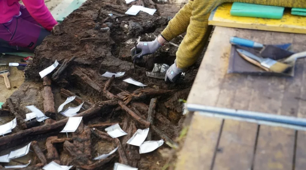
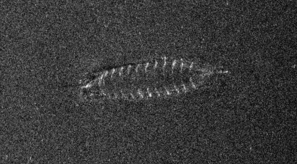
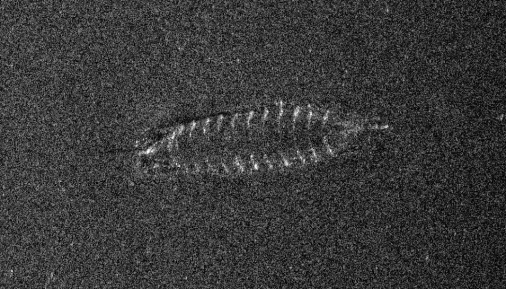
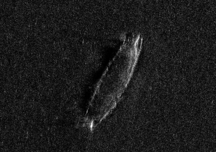
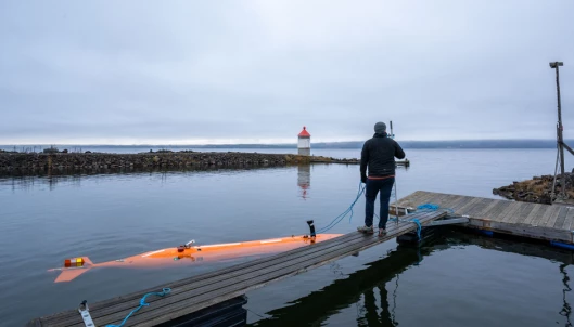
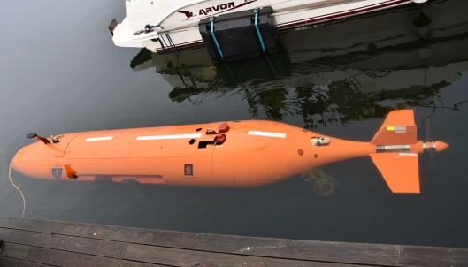
The mapping of the sea bottom of Mjøsa started a couple of weeks ago. It yielded results on the very last day. At 410 metres, the autonomous underwater vehicle Hugin from the Norwegian Defence Research Establishment found a shipwreck.

“If we found a medieval ship, we would really be hitting the bullseye, it would be fantastic, but we don’t dare to hope yet,” Ødegård said in an article about exploring Mjøsa two years ago. Now it seems they may have found just that.

Possibly a medieval shipwreck

The ship is about ten metres long – it’s possible that it originally was a bit longer – and 2,5 metres wide. This places it somewhere in between the categories of a large boat or a ship, according to Ødegård.

At one end, it looks as though the strakes are no longer fastened properly to the ship, which indicates that the iron nails fastening them have probably begun to rust and disintegrate.

“This tells us that the ship has probably been at the bottom of Mjøsa for a while,” Ødegård says.

The Norwegian newspaper VG excitedly announced for a brief time that the archaeologists had discovered a Viking ship, but this is not the case.

Ødegård explains that Viking ships usually have the steering oar on the side of the ship. During the Middle Ages, the steering oar was rather placed right at the back of the ship – and judging by the images obtained, this is what the shipwreck in question has.

“If this is correct, it is highly likely that the ship is not older than from the 1300s,” Ødegård says.

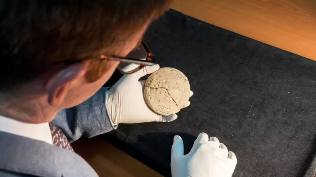
The ship is clinker built, a Nordic tradition of ship building also known from the Viking ships and listed on the UNESCO list of Intangible Cultural Heritage.

“This tradition is recognized as a very important part of our cultural heritage,” says Ødegård.

Naval battles and trade routes

The Norwegian Defence Research Establishment was given the task of mapping Mjøsa by The Norwegian Environment Agency. The job was to find possible explosives and ammunition that may have been dumped in the lake by an ammunition factory which is said to have done so between the 1940s and up until the 70s. Researchers from NTNU had simultaneously started up a project about Mjøsa, and so a collaboration came about.

“We realized that the entire lake is more or less unknown territory,” says Ødegård.

NTNU has therefore started up a research project about Mjøsa starting next year, which will go on for about five years.

Vice principle for NTNU, in Gjøvik, Gro Dæhlin, says to the newspaper VG that Mjøsa is a treasure trove for old ships.

Director of Mjøsmuseet, Arne Julsrud Berg, is also very excited about the find.

He tells VG that there were huge naval battles on Mjøsa in the 1100s and 1200s, when large fleets including ships the size of the famous Gokstad Viking ship met in battle on the water.

“Even during the Viking Age there were huge sea battles on Mjøsa,” Berg says to VG.

The areas surrounding Mjøsa were wealthy farm areas, and goods have been transported across Mjøsa to and from Oslo throughout the centuries.

More to come

Raising the ship would probably pose a very complex task.

“I don’t know if that has ever been done with robots,” says Ødegård.

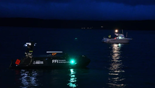
On Thursday evening this week, having discovered the shipwreck in the sonar images from FFI, Ødegård and the team went out to try and get better images with a different robot, but the waters were too rough.

“What we want to do now is to get data from cameras and other sensors. We can blow away some sand from sediments with the propels on the robot, and we can use manipulator arms, but it will be what we call a non-intrusive investigation at first,” says Ødegård.

The two-week mapping only covered around 40 square kilometres of the 360 sqare kilometre large lake. More ships may turn up – within the next few days, when the researchers analyse more of the data collected, or sometime during next spring, when the next field trip will take place.

“Because this is a freshwater lake, the wood in such a ship is preserved. The metal may rust, and the ship may lose its structure, but the wood is intact. A similar ship to the one we now found, would not have survived for more than a few decades if it had gone down on the coast,” Ødegård says.

“So if we are going to find a Viking shipwreck in Norway, then Mjøsa is probably the place with the most potential for such a find,” he says.

Were Europe’s Early Humans Connected to Each Other?

Were Europe’s Early Humans Connected to Each Other?

Were Europe’s Early Humans Connected to Each Other?
Part of the tibia of an early human believed to be Homo heidelbergensis was discovered at the Boxgrove archaeological site in West Sussex.

Piecing together the story of human evolution is an undeniably complex task. However, new research has brought us closer to understanding how early humans in Britain may have been related to other European populations over 400,000 years ago. In the 1990s, part of a lower leg bone and two fossil teeth were unearthed at an archaeological site in Boxgrove, West Sussex.

Dating to around 480,000 years ago during the Middle Pleistocene, the Boxgrove fossils are the oldest human remains discovered in the UK and were identified as most likely belonging to the ancient human species Homo heidelbergensis. Scientists are now trying to determine if the Boxgrove humans belong to the same population as other early human fossils discovered at Sima de Los Huesos (meaning ‘pit of bones’) at the Archaeological site of Atapuerca in Spain, which date to a similar time period.

The new study, published in the Journal of Human Evolution, found that the incisor teeth from Boxgrove fit comfortably within the range of fossil teeth found at the Sima site in Spain. Therefore, they could potentially represent similar populations. However, the Boxgrove leg bone, or tibia, differed significantly from those discovered in Spain, suggesting it could be from entirely separate populations.

Professor Chris Stringer, an expert in human evolution at the Museum and co-author of the study, says, ‘We’ve got two options. First, suppose the Boxgrove incisors and tibia are from the same population. In that case, they belong to a different population than the sample in Spain because the Boxgrove tibia has more primitive features.’

‘However, because the Boxgrove incisors were found lower and therefore earlier in the sequence of deposits than the tibia, the other option is that those individuals at Boxgrove represent two different populations. In other words, the incisors at Boxgrove and Sima could represent the same population, but the Boxgrove tibia people are different. So that’s the issue.’

Four human species are represented here (H. erectus, H. heidelbergensis, H. neanderthalensis, H. sapiens).

What is Homo heidelbergensis?

Homo heidelbergensis is a species of early human first described from a fossil jawbone discovered near Heidelberg in Germany in 1907. It’s often argued that this species not only lived in Europe but also in Africa and probably Asia between 700,000 and 300,000 years ago. However, some researchers feel that the name has been applied to too wide a range of fossils from this period of time.

The discovery of stone tools more than 700,000 years old from sites in Suffolk and Norfolk shows that humans were living in Britain long before those from Boxgrove. However, the Boxgrove fossils are the earliest human remains in Britain for which there is currently physical rather than archaeological evidence. But trying to define whether they belong to H. heidelbergensis is not easy.

‘The whole heidelbergensis story has become much more complicated,’ says Chris. ‘Since the Boxgrove discovery, many more fossils have been attributed to heidelbergensis and they show a lot of variation. When the fossils at Sima de los Huesos started to be found in the 1990s, they were also called Homo heidelbergensis.’

‘If a fossil didn’t appear to belong to Homo erectus, Homo sapiens or Neanderthals, it was often placed into the category of Homo heidelbergensis. But more work has since been done on the Sima sample, which showed it was much more likely to be early Neanderthal based on physical features and DNA analysis.’

Why are the fossils at Boxgrove compared with those in Spain?

The fossils found at Sima de los Huesos represent the biggest sample of early human fossils ever discovered from the Middle Pleistocene epoch.

Many of these fossils are unusually well preserved and are thought to come from around 29 separate people. Therefore, this site can reveal a lot about this population that existed about 430,000 years ago.

‘Trying to piece together how human populations were similar during the Middle Pleistocene is tricky as fossils are very rare and scattered,’ says Chris. ‘It’s hard to piece the evidence together when we’re trying to match a jawbone from Germany with a leg bone from Britain.’

‘The sample of fossil humans from Spain is by far the biggest from this time period from anywhere in the world. So we can compare the two incisors and tibia from Boxgrove with the 22 incisors and seven tibiae from the Sima sample.’  

‘We found that the Boxgrove incisors fitted within the Sima sample comfortably, and hence might also represent an early Neanderthal population rather than heidelbergensis, but the tibia did not match with those from the Sima. Hence the tibia is something different, but whether it represents heidelbergensis or something else, we cannot tell from this research. ‘

Scaffolding covers the hillside of an archaeological site at Atapuerca in Spain.

How were the fossils analysed?

To determine the relationship between the fossils, the team studied external features and used CT scanning for a more in-depth analysis.

Dr Lucile Crété, Museum researcher and co-author of the study, says, ‘Advances in the field of 3D imaging and virtual reconstruction analysis over the last few years has helped to further our knowledge of fossil teeth and bone morphology and structure across the complex Middle Pleistocene hominin fossil record.’

‘CT data acquired for this study has been essential to compare the Boxgrove and Sima de los Huesos fossils and other comparative material to help make a coherent story.’

Since the discovery of the Boxgrove fossils, more material from the Middle Pleistocene has been analysed in even more detail. However, the story of human evolution and how populations were related has been revealed to be even more complex.

Dr Matthew Pope, a co-author on the paper, says, ‘This research brings us a step closer to understanding how the Boxgrove people were related to other European populations in the Pleistocene.’

‘The picture is complex, given the teeth appear close to those from Sima and the tibia a little more distant. But we must remember that they were found in different sediments at the Boxgrove site. Establishing how separated in time these sediments are from each other is now an important research question for science to address.’

Colonnaded Hall Discovered in Egypt’s Nile Delta

Colonnaded Hall Discovered in Egypt’s Nile Delta

Remains of the colonnades hall of Butu Temple were uncovered during excavations carried out by an Egyptian archaeological mission at Tel Al-Farayeen, Kafr El-Sheikh in the northern Nile Delta.

Colonnaded Hall Discovered in Egypt’s Nile Delta

A collection of pots used in religious rituals was unearthed along with decorated stone engravings depicting scenes that date back to the 26th Dynasty Saitie period.

The hall, has three aligned columns in ruins with a probable papyrus on the top – emblematic of the of prevailing art forms in that period – could be associated withe deity Wadjet who is the master of Butu Temple.

The mission also unearthed a limestone relief showing a deity with a bird head wearing a white crown surrounded by feathers – possibly Nekhpet or Mut.

“This is a very important discovery,” said Mostafa Waziri, secretary-general of the Supreme Council of Antiquities.

“It shows a major part of the temple, which sheds light on the original plan of the temple and the architectural design of the surrounding area extending for 11 feddans,” Waziri added.

He noted that the area was surrounded by a huge mud brick wall built during the New Kingdom.

More height was added to the wall during the Saitie period, he explained.

A small limestone shrine, pots, and vessels were also discovered in the temple area.

“The shrine might have been built to preserve small statues sacrificed for the temple,” said Ayman Ashmawi, head of the Ancient Egyptian Antiquities Sector at the Supreme Council of Antiquities, adding that excavations will continue to reveal more secrets of the site.

The mission had earlier uncovered a huge stone building with tools used in religious rituals and a collection of distinguished scenes carved in ivory and inlaid with gold and hieroglyphic engravings.

46 Eagles in vivid colour revealed on Ancient Egyptian temple ceiling

46 Eagles in vivid colour revealed on Ancient Egyptian temple ceiling

A joint German/Egyptian archaeological mission at the Temple of Esna on the west bank of the Nile, 35 miles south of Luxor in Egypt, has revealed some original colours and patterns in the part of the temple complex during restoration work.

Sand dust, filth, salt efflorescence, and bird and bat guano and bones had collected on the walls, ceilings, and columns over the ages, obscuring the inscriptions to the point that they were almost invisible to the human eye.

The construction of the Esna Temple dates from Ptolemaic times, however, most of the parts that survive today are from the Roman period.

The Esna Temple is dedicated to the Ancient Egyptian god, Khnum, and his consorts Menhit and Nebtu, their son, Heka, and the goddess Neith.

46 Eagles in vivid colour revealed on Ancient Egyptian temple ceiling
46 eagles in vivid colour revealed on Ancient Egyptian temple ceiling

The restoration project found the original colours and patterns under the middle ceiling above the entrance to the temple.

A careful process of cleaning revealed a painting that depicts 46 eagles in a row, 20 of which have an eagle head (representing Upper Egypt), whilst the remainder is the head of a cobra (representing Lower Egypt).

The murals on the middle ceiling over the entry hall are particularly noteworthy. The ceiling is more than 45 feet high and decorated with 46 eagles in two rows.

The goddess Nekhbet and Upper Egypt are represented by twenty-four of them, which have eagle heads. Wajit, the goddess of Lower Egypt, is represented with twenty-two cobra heads. Between 1963 and 1975, French Egyptologist Serge Soniron studied and photographed the temple inscriptions, but the ceiling with the 46 eagles was never recorded or published.

Dr. Hisham El-Lithy, head of the Central Administration for Egyptian Archaeology Registration and Head of the Egyptian Archaeological Mission said: “The colourful inscriptions have suffered over the past centuries from the accumulation of thick layers and impurities.”

Researchers also discovered Greek inscriptions written in red ink while cleaning the western wall of the temple.

It was discovered in the temple axis’ western wall frieze, totally buried in layers of black soot.

The inscription specifies the date and month, Epiphi 5, which corresponds to late June or early July during Emperor Domitian’s reign (81-96 A.D.) Archaeologists think that this is the date when the Esna Temple was finished.

Hima, a rock art site in Saudi Arabia, added to the UNESCO World Heritage List

Hima, a rock art site in Saudi Arabia, added to the UNESCO World Heritage List

The rock art site Hima in Najran has been included in the UNESCO World Heritage List, becoming the sixth registered site in Saudi Arabia.

Hima, a rock art site in Saudi Arabia, added to the UNESCO World Heritage List

The site is located in southwestern Saudi Arabia and has one of the largest rock art complexes in the world.

Saudi Arabia’s rock art has gained popularity in recent years and is considered to be one of the richest in the world, in addition to other rock paintings in Australia, India, and South Africa.

Hima was a conduit for caravans on the Hajj and trade routes going to and from the southern parts of Arabia, to the ancient world markets of Arabia, Mesopotamia, the Levant, and Egypt.

People who passed through the area between prehistoric and post-historic times have left behind a substantial collection of rock art depicting hunting, wildlife, plants, symbols, and tools used at the time, as well as thousands of written inscriptions in various ancient writings including Musnad, Thamudic, Nabataean, and the early Arabic.

Hima a rock art site in Najran has been added to UNESCO’s World Heritage List, becoming the sixth Saudi site to find a place in the coveted list.

Dr. Jasir Alherbish, CEO of the Heritage Commission, stated, “The region has great global significance, providing us with numerous lessons regarding the evolution of human civilization and life in ancient times.” (Saudi Gazette)

“We are thrilled to have this exceptional ancient site recognized by UNESCO as a World Heritage Site.

“We are working to preserve the area and conduct research to further understand the rock inscriptions, and are looking forward to welcoming more local and international visitors to come and see this historic cultural site for themselves.”

The Kingdom’s 2030 Vision prioritizes the preservation and protection of the Kingdom’s cultural and natural assets.

A slew of fresh finds, overseen by the Heritage Commission, has reinforced the country’s status as a go-to destination for archaeologists, historians, and scientists interested in regional human history.

The Kingdom has also taken significant steps to safeguard national and international cultural assets.

The Ministry of Culture signed a Memorandum of Understanding with UNESCO in 2019, agreeing to donate $25 million to the organization’s global heritage protection plan.

A 7,800-year-old female figurine discovered in Ulucak Höyük in western Turkey

A 7,800-year-old female figurine discovered in Ulucak Höyük in western Turkey

A 7,800-year-old female figurine discovered in Ulucak Höyük in western Turkey

A 7,800-year-old female figurine was found in the Ulucak Höyük (Ulucak Mound) in the Kemalpaşa district of Izmir.

It was stated that the figurine made of clay was used in various rituals such as increasing abundance and fertility. Generally, such artefacts are found broken and the number of artefacts found as a whole is quite low. A very rare artefact. Third work ever found as a whole.

With the support of the Turkey Ministry of Culture and Tourism, İzmir Metropolitan Municipality, Kemalpaşa Municipality, and Kemalpaşa Organized Industrial Zone, excavations in İzmir’s oldest settlement, the 8,850-year-old Ulucak Höyük, started this year as well.

Trakya University Faculty of Letters Protohistory and Near Eastern Archaeology Faculty Member of the Department Professor Dr. Özlem Çevik took over the excavation directorship in 2009, and the first find of this year was unearthed during the work on the mound.

Earlier excavations revealed that Ulucak Mound hosted the first farmers of the Aegean Region; It had revealed that the first settlers built their houses on top of each other along the 7.5-meter cultural layer and settled in the same place for 1150 years without interruption.

Professor Özlem Çevik said the female figurine was 8 cm tall and about 7,800 years old.

Ulucak Mound, located in the Ulucak district of Kemalpaşa county on the 15th km of Bornova-Ankara road, was the location of one of the oldest settlements of Western Anatolia and it illuminates cultural history both by its architectural structure and its foundlings.

Excavations were started in 1995 and three cultural layers were identified.

These are the Late Roman period at the top; the Early Bronze Age layers underneath Early Byzantine settlements and the Late Neolithic settlement at the bottom.

In the excavations, a large number of ceramic pots, tools made of ganister, stone weapons, mother goddess figurines, and anthropomorphic pots were unearthed, some of which are exhibited in the Izmir Archeology Museum.

The oldest grave in northern Germany is 10,500 years old

The oldest grave in northern Germany is 10,500 years old

The oldest grave in northern Germany is 10,500 years old

Archaeologists have discovered the oldest known human remains in northern Germany in a 10,500-year-old cremation grave in Lüchow, Schleswig-Holstein.

The remains were discovered in the Duvensee bog, a prehistoric inland lake that contains more than 20 Mesolithic and Neolithic archaeological sites.

The bog’s anaerobic environment preserves organic remains, including burned bones, but there was so little left that it wasn’t until the team discovered a human thigh bone that they were able to confirm they had discovered a burial.

Burials of hunter-gatherer-fisher people who lived in Europe during the early Mesolithic period are extremely rare. Mesolithic burials have previously been discovered in northern Germany and southern Scandinavia, but only from the Late Mesolithic period (7th-6th millennia B.C.).

The only burial that was comparable in time was discovered in Jutland, Denmark. It, too, is a cremation burial, an indication that cremation may have been the preferred method of burial among Mesolithic hunter-gatherers.

Archaeologists unearth the oldest burial site to date in northern Germany.

Several bone fragments that were not completely charred were found during the excavation. Excavation director Harald Lübke hopes to recover archaeological DNA from them.

The entire grave was raised in a soil block for additional excavation and laboratory study.

Archaeologists have been excavating Duvensee Moor since 1923 and have also discovered the shelter of Stone Age hunters and gatherers.

The oldest known North German raises a lot of questions. For example, according to the circumstances of death. In the case of burned bones, it is difficult to determine the cause of death, says Harald Lübke.

For archaeologists, the entire Duvenseer Moor is a hotspot. “We’ve only opened a new door here at the moment. But behind it, there are only dark rooms at the moment.”

Due to their spectacular cremation find, they will probably continue digging there in the coming year.

Babylonians used the Pythagorean theorem 1,000 years before it was ‘invented’ in ancient Greece

Babylonians used the Pythagorean theorem 1,000 years before it was ‘invented’ in ancient Greece

Babylonians used the Pythagorean theorem 1,000 years before it was 'invented' in ancient Greece
The tablet was used by a surveyor to accurately divide up the land.

A 3,700-year-old clay tablet has revealed that the ancient Babylonians understood the Pythagorean theorem more than 1,000 years before the birth of the Greek philosopher Pythagoras, who is widely associated with the idea.

The tablet, known as Si.427, was used by ancient land surveyors to draw accurate boundaries and is engraved with cuneiform markings which form a mathematical table instructing the reader on how to make accurate right triangles. The tablet is the earliest known example of applied geometry.

A French archaeological expedition first excavated the tablet, which dates to between 1900 and 1600 B.C in what is now Iraq in 1894, and it is currently housed in the Istanbul Archeological Museum. But it is only just now that researchers have discovered the significance of its ancient markings.

“It is generally accepted that trigonometry — the branch of maths that is concerned with the study of triangles — was developed by the ancient Greeks studying the night sky,” in the second century B.C., Daniel Mansfield, a mathematician at the University of New South Wales in Australia and the discoverer of the tablet’s meaning, said in a statement.

“But the Babylonians developed their own alternative ‘proto-trigonometry’ to solve problems related to measuring the ground, not the sky.”

According to Mansfield, Si.427 is the Old Babylonian period’s only known example of a cadastral document, or plan surveyors used to define land boundaries. “In this case, it tells us legal and geometric details about a field that’s split after some of it was sold off,” Mansfield said.

The tablet details a marshy field with various structures, including a tower, built upon it. The tablet is engraved with three sets of Pythagorean triples: three whole numbers for which the sum of the squares of the first two equals the square of the third. The triples engraved on Si.427 are 3, 4, 5; 8, 15, 17; and 5, 12, 13. These were likely used to help determine the land’s boundaries.

The tablet’s significance went unrecognized for more than 100 years until it was tracked down.

Though the tablet does not express the Pythagorean theorem in the familiar algebraic form it’s expressed in today, coming up with those triples would have required understanding the general principle that governs the relationship between the length of the sides and the hypotenuse.

In 2017, Mansfield had discovered a tablet from the same period, named Plimpton 322, which he identified as containing another trigonometric table. But it wasn’t until he saw the triples on Si.427 that he was able to piece together that the ancient Babylonians were using rudimentary trigonometric theory to split up parcels of land.

Si.427 is thought to pre-date Plimpton 322 — and may have even inspired it, Mansfield said.

“There is a whole zoo of right triangles with different shapes. But only a very small handful can be used by Babylonian surveyors. Plimpton 322 is a systematic study of this zoo to discover the useful shapes,” Mansfield said, referring to the fact that different types of right triangles can have different interior angles.

“This is from a period where land is starting to become private — people started thinking about the land in terms of ‘my land and your land’, wanting to establish a proper boundary to have positive neighbourly relationships. And this is what this tablet immediately says. It’s a field being split, and new boundaries are made.”

Although the reasons behind the calculations of land boundaries on the tablet aren’t entirely clear, Si.427 does mention a dispute over date-palms on the border between the properties of a prominent individual called Sin-bel-apli and a wealthy female landowner, according to Mansfield. “It is easy to see how accuracy was important in resolving disputes between such powerful individuals,” he said.

Even though 1,000 years would pass between the creation of the tablets and the birth of Pythagoras of Samos in 570 B.C. — leading to the formalized Pythagorean rule students are taught in school today — experts have long known that the Greeks inherited mathematical teachings from Egyptians, and the Egyptians in turn from the Babylonians.

What is surprising to Mansfield, however, is the level of theoretical sophistication the tablets reveal the ancient Babylonians to have had at such an early stage of human history.

“Nobody expected that the Babylonians were using Pythagorean triples in this way,” he said. “It is more akin to pure mathematics, inspired by the practical problems of the time.”

All In One Magazine