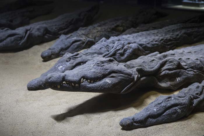
Late Roman Era Sarcophagus Found By Turkish Farmer

Late Roman Era Sarcophagus Found By Turkish Farmer

A project in Turkey to stop illegal excavations has resulted in the discovery of rare sarcophagi. To detect the looters, the authorities used the new surveillance technologies, which in turn led to these unexpected discoveries.

The findings are related to Aphrodisias and may have originated from a part of the ancient city that was previously unknown.

Turkish authorities have been notified of possible illegal excavations in Karacasu, a town near Aphrodisias, a Hellenistic-era city and a UNESCO World Heritage Site, in western Turkey.

Late Roman Era Sarcophagus Found By Turkish Farmer
After being tipped off about suspicious activity, Turkish authorities conducted surveillance which led to the impressive discovery of an illegal dig which had unearthed the sarcophagi in Turkey.

Officials decided to monitor the activities of the looters by setting up motion-sensitive cameras to detect any possible criminal activity. Drones were also employed as part of the operation.

After weeks of surveillance, a group of men was detected in the area. The local gendarmerie investigated and uncovered signs of an illegal excavation in an olive grove. Further investigations revealed a half-unearthed sarcophagus.

The authorities immediately placed the site under their protection. Further investigations also revealed another sarcophagus and an altar.

Surveillance Operation Uncovers Illegal Excavation

The district governor Ahmet Soley is quoted by Archaeology News Network as saying that groups of people were coming from elsewhere and were engaging in suspicious activity. “As a result of the gendarme’s work, the places to be excavated were found and two sarcophagi, along with an altar, were discovered in the area.”

However, the treasure hunters behind the illegal excavation got away. Greece in High Definition reports Soley as saying that “the perpetrators of the illegal diggings are still unclear.”

One of the sarcophagi is better preserved than the other and still has many of its original decorations. According to Greece in High Definition, the Provincial Culture and Tourism Director Umut Tuncer announced that “there is a Medusa relief among others that have not yet been identified on one of the sarcophagi.” The identity of the person who was buried in this tomb has not been established.

Authorities excavating one of the impressive sarcophagi discovered near Karacasu in western Turkey.

Given the size of the sarcophagus, it is likely that the person interred was a member of the local elite. Tuncer is quoted by Archaeology News Network as explaining that the authorities believe that “the person in this sarcophagus was an important figure of the region.” It is estimated that the burials date back to at least 2,300 years ago to the Hellenistic era.

The finds are probably connected to the city of Aphrodisias, an ancient Greek City named after the Goddess of Love, Aphrodite.

The city grew wealthy because of its rich agricultural hinterland. Aphrodisias was also famed for its marble and its school of sculptors.

The city became part of the Roman province of Caria and it was favored by Sulla and Julius Caesar. As a result, it was largely autonomous. The city’s name after the rise of Christianity was “changed to Stavropolis and then Caria, and it became the seat of the metropolitan bishop of Caria,” explains an entry in the Encyclopaedia Britannica.

It went into decline and was abandoned during the Seljuk Turk invasions of Anatolia in the Middle Ages.

The discovery of the sarcophagus means that it is likely that other burials could be found. But that’s not all! Experts also believe that the sarcophagus has revealed a new part of the city. This could mean that even more important finds and long-lost structures could be recovered at a future date.

The remains of the city of Aphrodisias are now part of an archaeology park, the centerpiece of which is the remains of a temple of Aphrodite. Thanks to its UNESCO designation, the park is very popular with tourists which has become increasingly important for the local economy.

The unexpected find has created excitement amongst local authorities as “the discovery of a new metropolitan area creates great potential in terms of regional tourism,” highlights Tuncer in Archaeology News Network.

The thrilling discoveries demonstrate the threat posed by illegal excavations and how technology can play a critical role in the prevention of this crime.

Archaeologists discover a secret Aztec tunnel built 600 years ago by emperor Moctezuma

Archaeologists discover a secret Aztec tunnel built 600 years ago by emperor Moctezuma

Archaeologists from the National Institute of Anthropology and History (INAH) discovered 11 pre-Hispanic images in a tunnel in Ecatepec, México’s state capital, that is part of a colonial dike system.

Petroglyphs and stucco relief panels were among the photos found on the sides of the 8.4-meter-long tunnel, according to INAH.

The tunnel is part of the Albarradón de Ecatepec, a four-kilometer-long 17th-century dike system.

Archaeologists discover a secret Aztec tunnel built 600 years ago by emperor Moctezuma
Archaeologists have unearthed a secret Aztec tunnel chamber that has been hiding under the bustling streets of Mexico City for more than 600 years

A war shield, the head of a bird of prey, and a “paper ornament” are among the images carved into the walls of the tunnels while a teocalli, or temple, is etched into the central stone of the arch entrance.

The temple is dedicated to the rain god Tláloc, the INAH archaeologists concluded.

Some of the images are still being studied to determine their exact nature and meaning.

Raúl García, coordinator of a project to preserve the archaeological treasures of the dike system, said that one hypothesis is that the images were made by indigenous people who lived in the pre-Hispanic towns of Ecatepec and Chiconautla. Residents of both towns worked on the construction of the dike, he said.

Adorned with carvings and paintings, the passageway that dates back to the 15th century is believed to have been built by Emperor Montezuma I and linked to the god of water and fertility – Tlaloc

The archaeologist explained that the tunnel where the images were discovered is in a section of the dike known as the Patio de Diligencias.

The glyphs and stucco panels, all of which have been damaged by hundreds of years of rain, will be covered for protection, García said.

The Albarradón de Ecatepec was declared a historical monument in 2001 and will soon be incorporated into a public park.

México state INAH director Antonio Huitrón said the opening of the park will allow people to enjoy the “cultural heritage to which they are heirs.”

The tunnel where the images were discovered will also be open to the public although the originals won’t be on display.

The site in which the wall was found is part of a more than decade long conservation project around la Calzada de San Cristobal

Aztecs were famous for their agriculture, introducing irrigation, draining swamps, creating artificial islands in the lakes and building intricate structures like

Huitrón said the stones featuring the petroglyphs and stucco panels will be removed and transferred to the Casa Morelos Community Center in Ecatepec. Stones with replicas of the images will be installed in their place, he explained.

Ecatepec, Mexico’s second most populous municipality, is located just north of Mexico City and is part of the Valley of Mexico metropolitan area.

Research uncovers how Christianity changed Anglo-Saxon burial practices

Research uncovers how Christianity changed Anglo-Saxon burial practices

In a field three miles south of Cambridge, the bones of a mysterious Anglo-Saxon princess who died thirteen and a half centuries ago have been discovered. She died at the age of 16 and was buried with a small solid gold Christian cross encrusted with garnets on her chest, lying on a special high-status funerary bed.

Research uncovers how Christianity changed Anglo-Saxon burial practices
The skeleton and a Christian cross were found in Trumpington Meadows, Cambs a site that has been confirmed as one of the UK’s earliest Christian burial sites.

Her true identity has yet to be revealed. However, she was most likely a member of one of the period’s newly Christianized Anglo-Saxon royal families.

She was buried fully clothed, her bronze and iron chatelaine (belt hook) and purse, still attached to her leather belt.

A clue to the circumstances of her death is the presence of three other individuals buried in separate graves alongside her (two women aged around 20 and one other slightly older individuals of indeterminate sex, but conceivably female).

Skeleton of an Anglo-Saxon teenager who was buried with the Trumpington Cross.

It’s likely that they died at the same time – probably from some sort of epidemic. Significantly, the Anglo-Saxon Chronicle mentions that England was devastated by the plague in 664 AD (around the very time that the archaeological evidence also suggests they died).

The archaeological investigation – carried out by Cambridge University Archaeological Unit – has also revealed that they were interred adjacent to a high-status settlement consisting of a 12-meter long timber hall and at least half a dozen other buildings with substantial semi-subterranean storage cellars.

Among the finds unearthed were fragments of posh French-originating shiny black ceramic wine jugs – in England a type of pottery previously found mainly on monastic sites.

The female graves, the high-status nature of the site, and the Christian burial rite all combine to suggest that the princess and her companions may well have been nuns – and that the settlement may have been part of a nunnery.

It’s known that the various newly Christianized Anglo-Saxon monarchs of the time competed with each other to establish monasteries and nunneries as proof of their Christian piety. Indeed it’s conceivable that the princess’s parents enrolled their daughter in such a nunnery to further demonstrate their commitment to their new faith (a common practice at the time).

The area itself probably enjoyed some sort of royal or otherwise elevated status inherited from Roman and immediately post-Roman times when it formed part of a native Romano-British territory centered on Cambridge and known as the Granta Saete – the territory (saete) of the River Granta (now more often known as the Cam).

Just 500 meters to the north of the princess’s grave in the village of Grantchester (derived from the ‘Granta Saete’ territorial name) – the site of what was once a substantial Roman villa, the owners of which conceivably became the area’s ruling family.

Historians believe that the Roman villa, the high-status Anglo-Saxon settlement, and the princess’s grave were in one of several quasi-independent mini-kingdoms which acted as buffer states between the larger kingdoms of East Anglia and Mercia (central England).

The princess may well, therefore, have been the daughter of a mid-7th-century king of Mercia or East Anglia or of one of the buffer states in between.

Continuing scientific investigations over the next few months are expected to reveal more information about the princess, her companions, and the site as a whole. Isotopic tests are likely to reveal their geographical origins by demonstrating where they had spent their early childhoods.

Other isotopic analyses will reveal their diet. Efforts will also be made to reconstruct aspects of the princess’s clothing from fragments of mineralized textile which survived in her grave.

“This is an incredibly important and exciting discovery which is already shedding remarkable new light on the early years of English Christianity,” said Alison Dickens, a senior manager at the Cambridge University Archaeological Unit.

The excavation carried out near the village of Trumpington, south of Cambridge, and the ongoing scientific investigations, have been funded by the Trumpington Meadows Land Company – a joint housing development venture between London’s Grosvenor property company and USS, the UK-wide universities pension scheme.

2,000-Year-Old Ancient Egyptian Child Mummy Revealed in Incredible Detail Through 3D Scanning Technology

2,000-Year-Old Ancient Egyptian Child Mummy Revealed in Incredible Detail Through 3D Scanning Technology

The remains of a little child, about 5 years old, was mummified and buried in Egypt about 2,000 years ago. She was dressed in fine linen with circular earrings, a belt, and an amulet, and all of her internal organs were removed.

2,000-Year-Old Ancient Egyptian Child Mummy Revealed in Incredible Detail Through 3D Scanning Technology
The CT scans were merged with 3D scans of the child mummy’s surface to create a single 3D model.

Now, a new technique that merges colorful 3D scans of the mummy’s surface with CT scans that look beneath the mummy’s wrappings will allow people to examine the mummy in amazing detail.

Though the new technique is being used to help tell this mummy’s story, researchers believe it will have many applications in archaeology, biology, geology, paleontology, and manufacturing.

Peering inside a mummy

Scientists peered beneath the mummy’s wrappings using CT scans in 2005. And more recently, they complemented that imaging with an Artec Eva handheld 3D scanner, which could take images of parts of the mummy that could be scanned without touching the mummy.

While a CT scanner is better at penetrating beneath the surface of the mummy wrappings, the handheld 3D scanner is able to scan in color, capturing details that a CT scanner cannot detect. Both scans were then combined into a single 3D model using software developed by Volume Graphics.

An Artec Eva handheld 3D scanner was used to scan the mummy’s surface.

The model will allow visitors to the Rosicrucian Egyptian Museum in San Jose, California, where the mummy is now located, to see the mummy in exceptional detail simply by using an iPad.

“Guests will be able to move an iPad over the mummy case, in order to see the associated scans,” Julie Scott, executive director of the museum, said in a statement.

“Our hope is that this new technology will help inspire guests to deeply relate to this little girl who lived so many years ago,” said Scott, noting that the girl’s real name is unknown, though scientists today call her “Sherit,” which is an ancient Egyptian name for “little one.”

Sherit, who may have died of dysentery and lived at a time when the Roman Empire ruled Egypt, is one of the first people/artifacts to be analyzed with the new technique.

Beyond mummies

The new technique will have many applications, the researchers said. It “allows for a more life-like, accurate representation of all kinds of objects and thus improves our understanding of these scanned objects,” Christof Reinhart, CEO of Volume Graphics, told Live Science.

“We can only imagine how this function will be used. Obvious applications in science would be archaeology, biology, geology, or paleontology.

“Industrial applications could arise in quality assurance — [for example], when optical features on the surface of an object are to be associated with features inside the object,” Reinhart added.

Mother Found Still Cradling Baby After 4,800 Years

Mother Found Still Cradling Baby After 4,800 Years

It is a fitting discovery as Mother’s Day approaches. Archaeologists have uncovered the ancient remains of a young mother and an infant child locked in a 4,800-year-old embrace. The remarkable find was among 48 sets of remains unearthed from graves in Taiwan, including the fossils of five children.

The mother is seen looking towards the child

Researchers were stunned to discover the maternal moment, and they say these Stone Age relics are the earliest sign of human activity found in central Taiwan.

Preserved for nearly 5,000 years, the skeleton found in the Taichung area shows a young mother gazing down at the baby cradled in her arms.

Researchers turned to carbon dating to determine the ages of the fossils, which they traced back to the Neolithic Age, a period within the Stone Age.

Excavation began in May 2014 and took a year for archaeologists to complete. But of all the remains found in the ancient graves, one pair set stood out from the rest.

‘When it was unearthed, all of the archaeologists and staff members were shocked.

‘Why? Because the mother was looking down at the baby in her hands,’ said Chu Whei-lee, a curator in the Anthropology Department at Taiwan’s National Museum of Natural Science.

According to the researchers’ measurements, the mother was just 160 cm tall, or 5 foot 2 inches. The infant in her arms is 50 cm tall – just over a foot-and-a-half.

Archaeologists say they have discovered the earliest trace of human activity in central Taiwan among graves from 4,800 years ago

This breathtaking discovery came as a surprise to the researchers on sight, but it isn’t the first of its kind.

In the past, archaeologists have dug up remains of similar moments which have been preserved for thousands of years.

Notably, Chinese archaeologists unearthed the interlocked skeletons of a mother and child last year from an Early Bronze Age archaeological site branded the ‘Pompeii of the East, the People’s Daily Online reported.

The mother is thought to have been trying to protect her child during a powerful earthquake that hit Qinghai province, central China, in about 2,000 BC.

Experts speculated that the site was hit by an earthquake and flooding of the Yellow River.

Photographs of the skeletal remains show the mother looking up above as she kneels on the floor, with her arms around her young child. Archaeologists say they believe her child was a boy.

Seahenge: A Subaquatic Monument of the European Bronze Age

Seahenge: A Subaquatic Monument of the European Bronze Age

Seahenge, which is also known as Holme I, was a prehistoric monument located in the village of Holme-next-the-Sea, near Old Hunstanton in the English county of Norfolk.

A timber circle with an upturned tree root in the center, Seahenge was apparently built in the 21st century BC, during the early Bronze Age in Britain. Contemporary theory is that it was used for ritual purposes.

The structure was perceived to be under threat from damage and erosion from the sea – as such it was fully excavated. This involved the removal of the timbers, a program of stratigraphic recording, and environmental sampling.

The structure comprised an elliptical circumference of fifty-five large oak posts and one smaller upright timber, set around an inverted oak tree.

Maximum diameter of 6.78m, with the tree, set slightly southwest of the center.

The central tree had two holes cut through the trunk on opposite sides, with a length of honeysuckle rope passed through the holes and tied in a knot.

A maximum of twenty-five trees was used to build the structure. Evidence of woodworking was recovered, including felling, trimming, splitting, and flattening.

422 pieces of wood debris were found, including woodchips. Toolmarks recorded from a total of fifty-nine possible tools; the maximum number of tools used is probably nearer 51.

The toolmarks are probably the largest assemblage of Early Bronze Age toolmarks yet recorded in Britain.

The structure was built at a single point in time. Dendrochronological dating of fifty-five samples revealed that the timber circle was constructed in the spring or early summer of 2049 BC, during the Early Bronze Age.

The environmental analysis demonstrated that the structure was built on a salt marsh. During the Bronze Age, freshwater reed swamp and alder carr spread over the saltmarsh and the monument itself.

Two timbers (context 35=37 and 65) may have been the first timbers set in place. These were placed on a southwest to northeast alignment, in the approximate direction of the midsummer rising sun and midwinter setting sun. This may have been deliberate or unintentional.

All but one of the circumference timbers were placed with their bark facing outwards. The timber with the split face facing outwards must have had significance.

The structure has been interpreted in various ways. These include a monument to mark the death of an individual, the death of a tree or the regenerative failure of trees, and the commemoration of an event, life, or the culmination of a celebration or festival.

The fragmentary remains of the timber circle are now in the King’s Lynn Museum.

Egyptian Pompeii: 3,000-year-old ‘lost golden city’ discovered in Egypt

Egyptian Pompeii: 3,000-year-old ‘lost golden city’ discovered in Egypt

A team has discovered the country’s largest known ancient site, So’oud Atun, or the “Rise of Aten,” in what experts are lauding as one of the most important Egyptian archaeological finds of the past century.

Egyptian Pompeii: 3,000-year-old 'lost golden city' discovered in Egypt
A team uncovered the lost city while searching for a mortuary temple last September.

Zahi Hawass, a famous—and controversial—Egyptian scholar, announced the discovery of the “lost golden city” near Luxor, site of the ancient city of Thebes, on Thursday. As BBC News reports, the city was established during the reign of Amenhotep III, between roughly 1391 and 1353 B.C.

Many of the Rise of Aten’s walls are well preserved. So far, the research team has identified a bakery, an administrative district, and a residential area, as well as scarab beetle amulets, pottery, and other everyday items.

Betsy M. Bryan, an Egyptian art specialist at Johns Hopkins University who visited the site but was not involved in the excavation, says in a statement that the find is “the second most important archeological discovery since the tomb of Tutankhamun.” (Through his father, Akhenaten, Tut is actually the grandson of Amenhotep.)

Archaeologists discovered the city in September while searching for a mortuary temple. It’s located close to a number of important ancient Egyptian monuments, including the Colossi of Memnon, the Madinat Habu Temple, and the Ramesseum.

Amenhotep, the ninth king of the 18th Dynasty, ruled during the second half of the New Kingdom period. He sponsored the construction of a number of huge temples and public buildings. Toward the end of his reign, he shared power with his eldest son, the soon-to-be Amenhotep IV.

Per National Geographic’s Erin Blakemore, the younger Amenhotep dramatically changed the country’s direction following his father’s death.

He abandoned all the Egyptian gods except the sun god Aten; changed his name from Amenhotep IV to Akhenaten, meaning “devoted to Aten”; and oversaw the rise of a new artistic movement. He and his wife, Nefertiti, also moved Egypt’s royal seat from Thebes to a new city called Akhetaten (now known as Amarna).

The city’s walls are well preserved, allowing archaeologists to see where its different districts were located.

The city’s walls are well preserved, allowing archaeologists to see where its different districts were located. (Egyptian Ministry of Tourism and Antiquities)

As Mia Alberti and Jack Guy report for CNN, the team found an inscription in So’oud Atun dated to 1337 B.C., just one year before Akhenaten established his capital at Amarna.

In the statement, Bryan notes that the newly discovered city offers a “rare glimpse into the life of the ancient Egyptians” at the height of the empire, in addition to shedding light on the mystery of why the pharaoh and his queen moved to Amarna.

After Akhenaten’s death, his son Tutankhamun’s government reversed his transformation of the country. Tutankhamen and his successor, Ay, continued to use the Rise of Aten, notes BBC News.

Egypt Today’s Mustafa Marie reports that the archaeologists examined hieroglyphic inscriptions on the lids of wine vessels and other containers for clues to the city’s history.

One vase containing dried or boiled meat was inscribed with the names of two people from the city and information showing that Amenhotep and Akhenaten ruled the city jointly at the time it was made.

The team also found a production area for mud bricks used to build temples and other structures. The bricks bear Amenhotep’s seal. Casting molds show that workers in the city produced amulets and decorations for temples and tombs; evidence of spinning and weaving exists at the site, too.

A zig-zag wall with just one entry point encloses an administrative and residential area, suggesting that authorities maintained security by limiting movement in and out.

One room within the city contains the burial of two cows or bulls—an unusual find that researchers are still investigating. In another odd discovery, the team found a human burial with the remains of a rope wrapped around the knees.

The team has not yet been able to fully explore a group of rock-cut tombs accessible through stairs carved into the rock.

“There’s no doubt about it; it really is a phenomenal find,” Salima Ikram, an archaeologist at the American University in Cairo, tells National Geographic. “It’s very much a snapshot in time—an Egyptian version of Pompeii.”

Victoria Cave: The underground Dales cavern that changed history

Victoria Cave: The underground Dales cavern that changed history

Victorian excavators were particularly fascinated by ‘bone caves’ where there might be a possibility of finding evidence for the earliest humans along with long-extinct animals.

The cavern near Settle is home to the skeletons of mammoths and Roman remains. Described as an ‘archaeologist’s dream’, Victoria Cave is made of limestone and can be found east of Langcliffe, in Ribblesdale.

It was discovered by chance in 1837 – the year Queen Victoria was crowned – and since then has yielded a number of incredible finds. It’s been completely excavated and has provided vital information about climate change over thousands of years.

Victoria Cave, the most famous of the ancient truncated caves that lie along Langcliffe Scar above Settle, although it was unknown until 1837 and discovered purely by chance. Stephen Oldfield

An amazing discovery

A group of men from Settle was out walking their dogs in 1837 when one of them disappeared inside a foxhole. Its owner, Michael Horner, followed and found himself in a passage that led to a cave with Roman objects clearly visible on the ground.

The original entrance discovered by Michael Horner: an ancient passage that once continued towards the camera and beyond. Stephen Oldfield
The artificial entrance leading to the excavated main chamber. Stephen Oldfield

He returned with his employer, Joseph Jackson, and the pair discovered a deeper chamber sealed from daylight. 20-year-old plumber Joseph had no knowledge of archaeology but began a large-scale candlelit excavation of the cave.

In 1840, he contacted Roman expert Charles Roach Smith, who visited the site just before Joseph dug up a hyena’s jawbone. A Victorian fascination with ‘bone caves’ soon developed, and the hunt for evidence of early man and the animals they had eaten began.

The excavated Main Chamber of Victoria Cave – once completely blocked by glacial sediment and containing the remains of animals over 120,000 years old. A passage known as Birkbeck’s Gallery can be seen leading off at the back. Stephen Oldfield

Charles Darwin himself even took an interest in Victoria Cave, and he became involved in another dig in 1870 that was linked to his emerging theories about human evolution. By this time, Joseph Jackson had become a full-time, eminent archaeologist.

Victoria Cave looked set to become a crucial archaeological and geological site – but two of the scientists involved later fell out over its contents.

The repercussions from the dispute, which centered around their conflicting views on cyclical climate change, led to Victoria Cave falling out of favor with the scientific community and it was gradually forgotten.

In the 1930s, the cave was re-discovered when a local greengrocer set up a society for cave explorers in his father’s pig yard. Tot Lord and his group collected as many of the artifacts as possible from the earlier digs and uncovered further remains.

His family has taken possession of the collection and archive material, and Victoria Cave returned to international prominence, with its importance highly valued. It offers the first proof that the Ice Age was cyclical and the final record of wild lynx living in Britain.

A prehistoric cache

Ancient bones found inside the cave, which is managed by the Yorkshire Dales National Park Authority, include those of mammoths, hippos, rhino, elephants, and spotted hyenas who lived in the Dales over 130,000 years ago – when the climate was warm enough to support species that are nowadays more commonly found in Africa.

After the last Ice Age, evidence that a brown bear had hibernated in the cave was uncovered, and reindeer bones were found. One of the key discoveries was a key indicator of the first human life in the Dales – an 11,000-year-old antler harpoon point used for hunting the deer.

Scene outside Victoria Cave 130,000 years ago.
This barbed harpoon point is made from deer antler and was found during the 19th-century excavations of Victoria Cave. The tip is broken. It dates to around 11,000 years ago and it probably arrived in the cave embedded in a scavenged or dying animal that had been hunted by the first known inhabitants of the Yorkshire Dales. An antler rod and ‘lance point’ were also found.

Roman remains

The area seems to have later been inhabited by the Romans – artifacts such as brooches, coins, and pottery from the period were buried in the cave, some of them imported from France and Africa.

Experts believe the cave could have been a religious shrine, with a workshop outside. Some of the items have been put on display at the Craven Museum in Skipton.

Access to the cave is limited as the roof is dangerously unstable, but walkers can visit the entrance.

All In One Magazine