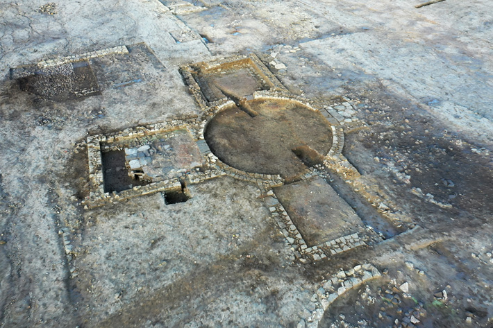
BBC News reports that a large villa complex with its own bathhouse has been discovered at a construction site in northern England. Keith Emerick of Historic England said the house, which has a circular central room flanked by additional rooms, is the first of its kind to be found in Britain.
Keepmoat Homes, which was hoping to develop a new housing estate in the Eastfield area of the North Yorkshire region, found the ruins of the settlement.
But the importance of the find may well have caused a headache for bosses of the firm, with Historic England saying it’s ‘easily the most important discovery of its kind.
The site will be reburied under a public space in the new housing development
Historians believe they’ve identified a whole complex of buildings. It includes a tower-shaped structure, which is thought to have had rooms and a bathhouse leading from it.
They are continuing to study the site, but so far it’s thought it would have been built by a wealthy landowner and could have become a religious building, a ‘stately home cum – gentleman’s club’, or even a combination of both.
Keith Emerick, inspector of ancient monuments at Historic England, said: ‘One of the descriptions we had was that it is something like a religious building that is almost like a gentleman’s club, there’s a bathhouse as well. So it’s a really interesting hybrid building at the moment.’
He added:
These archaeological remains are a fantastic find and are far more than we ever dreamed of discovering at this site. They are already giving us better knowledge and understanding of Roman Britain.
We are grateful to Keepmoat Homes for their sensitive and professional approach to helping ensure the future conservation of this important historical site.
Emerick told The Guardian: ‘It’s not like a jigsaw, where each new discovery adds to the picture, each new discovery actually gives a twist to the kaleidoscope and changes the picture entirely. This is a really exciting discovery and definitely of national importance.’
The complex of buildings includes a circular room and a bathhouse
Not only is it a first for Britain, but it could also be a first for the whole of the former Roman Empire.
Emerick added: ‘I would say this is one of the most important Roman discoveries in the past decade, actually. Easily.’
Keepmoat Homes have changed the initial plans and will not build on top of the site, but will still build in the area.
Historic England hopes the remains will be accessible to the public in future.
In the UK found children’s shoes which is 600 years old
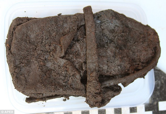
A child’s shoe discovered during an excavation in Devon maybe hundreds of years old. When archaeologists discovered the ancient footwear during a dig in Newton Abbot, they were shocked.
The leather shoe, which has been well-preserved in the site’s clay soil, maybe from the 1400s.
The team involved in the dig have voiced their excitement at finding such an everyday object intact after centuries in the ground.
Archaeologists carrying out a dig in the heart of Newton Abbot in Devon have unearthed an ancient leather shoe which could date back to the 1400s
‘It’s this day-to-day stuff which is exciting,’ said Simon Sworn, of Cotswold Archaeology and the site’s senior archaeological project officer.
‘The job is not all about kings under car parks,’ he added.
Along with the shoe, a number of other artifacts have been unearthed at the site.
Other historic treasures include an iron spur from a child’s boot, three wooden barrel bases, and a 27 inch (70 cm) diameter Dartmoor granite millstone, used to grind wheat into flour.
‘We will keep going down until we hit natural geology – or water at the site makes it unsafe,’ added Mr. Sworn.
The team is hoping to uncover more household artifacts dating back to the 13th century when Newton Abbot was a hastily built new town of its day.
Other historic treasures include an iron spur from a child’s boot, three wooden barrel bases and a 27 inch (70 cm) diameter Dartmoor granite millstone, used to grind wheat into flour (pictured)
Mr. Sworn explained: ‘As the name suggests, Newton Abbot was essentially founded as a medieval new town but there is some evidence for 6th/7th-century activity in the immediate vicinity of the site so we may find earlier remains lurking below the medieval burgage plots.’
He added: ‘We’ve been learning a lot about how the town developed and how it came to be the place we live in – and who the people were who made Newton Abbot what it is today.’
A number of well-preserved wooden barrels were found in waterlogged the clay soil (pictured)
Conditions at the site (pictured) have enabled artifacts to be so well preserved due to a lack of oxygen in the soil
Conditions at the site have enabled artifacts to be so well preserved due to a lack of oxygen in the soil.
The waterlogged conditions have enabled organic materials such as leather and wood, which would have rotted long ago, to last for centuries.
‘I’ve never worked on a site where so much local interest has been shown,’ added Mr Sworn.
He added: ‘A lot of perceptive questions have been asked – and we’ve been happy to answer them.
‘Over the next few weeks, we will gradually peel away the medieval layers and go deeper.’
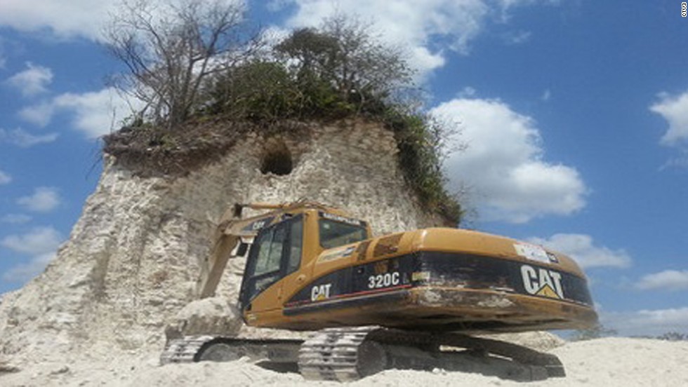
Ancient Mayan pyramid destroyed in Belize by the construction company
A construction company in Belize destroyed one of the oldest and most famous Mayan pyramids while digging for crushed rock for a road they were constructing.
Authorities reported that the company was carrying out the work with bulldozers and backhoes, chipping away at the pyramid’s sides until there was barely anything left.
The Belize Institute of Archaeology’s director, Jaime Awe, said the building had been discovered the previous week. The ceremonial center at the Nohmul complex is thought to be at least 2,300 years old, and it is considered the most significant historical site in northern Belize, near the Mexican border.
The pyramid, which stood 65 feet tall, was built around 250 B.C. with hand-cut limestone bricks. The pyramid probably contained living quarters as well as tombs for local residents.
The limestone from which the pyramid is made is prized by local contractors for building and repairing.
“It’s a feeling of Incredible disbelief because of the ignorance and the insensitivity … they were using this for road fill,” Awe told AP. “It’s like being punched in the stomach, it’s just so horrendous.”
Nohmul is located in the middle of a privately owned sugar cane field and its structures lacked the tell-tale signs of a restored cultural site – like the evenly trimmed stone borders at the sides.
Yet, Awe said this could not possibly have been an explanation for how the workers had managed not to take note of what they were doing.
The pyramid is 100 feet (30 meters) tall, while the land around it is flat, so making that kind of mistake is difficult to imagine.
“These guys knew that this was an ancient structure. It’s just bloody laziness”, Awe continued. “Just to realize that the ancient Maya acquired all this building material to erect these buildings, using nothing more than stone tools and quarried the stone, and carried this material on their heads, using tump lines,” he said.
“To think that today we have modern equipment, that you can go and excavate in a quarry anywhere, but that this company would completely disregard that and completely destroyed this building.
Why can’t these people just go and quarry somewhere that has no cultural significance? It’s mind-boggling.”
An investigation is underway by Belizean police, with criminal charges looking like a possibility. Although the Nohmul complex is situated on private land, the law says that any ruins or monuments of pre-Hispanic origin are exempt from it and are under government protection.
A community organization calling itself the Citizens Organized for Liberty through Action has condemned the demolition of the site as “an obscene example of disrespect for the environment and history.”
Hundreds of Mayan ruins remain in Belize, which is largely covered with jungles and counts around 350,000 people among its population. Although this is not the first case that such lack of regard was employed in Belize, Nohmul is among the largest pyramids ruined by such activities.
Archeologists in the area are outraged and hope to salvage artifacts from the rubble.
Many scientists spoke out against what happened. Arlen Chase, chairman of the Department of Anthropology at the University of Central Florida, told AP that “Archaeologists are disturbed when such things occur, but there is only a very limited infrastructure in Belize that can be applied to cultural heritage management.”
The ’70s and 80’s saw much exploration take place around the Nohmul area, but it is important to understand that more knowledge could still be gained, as scientists say.
And such instances of lazy negligence and destruction of Mayan cultural heritage aren’t limited only to Belize. The remnants of the great Mayan nation are under threat in Mexico, Guatemala, and Honduras as well.
Francisco Estrada-Belli, a professor of anthropology at Tulane University, said “I don’t think I am exaggerating if I say that every day a Maya mound is being destroyed for construction in one of the countries where the Maya lived.”
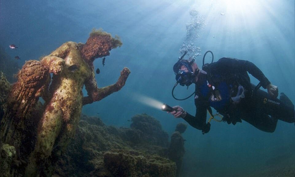
The sunken Roman city now lies beneath the waves off of Italy
The sunken city of the Caesars, which has been lost beneath the waves off Italy’s west coast for 1,700 years, has been revealed in stunning new photographs taken by divers who were given permission to explore the region. According to historians, Baiae was ancient Rome’s Las Vegas for the super-rich, with sprawling mansions and a reputation for luxury and wickedness.
Baiae was the Las Vegas for the super-rich of ancient Rome, covered in sprawling mansions and synonymous with luxury and wickedness, historians claim. The 1st Century city has been revealed in stunning new photographs taken by divers who were allowed to explore the area
However, when volcanic activity forced the coastline to retreat 400 meters inland, driving the entire city underwater into what is now the Gulf of Naples in modern-day Italy, most of it was lost to the sea. The site has since been re-discovered, 1,700 years after disappearing beneath the waves on the west coast of Italy. Divers were allowed to explore the site recently and snapped photos of the treasures that can still be found in the underwater city.
Antonio Busiello, who lives in Naples, photographed the site and found that roads, walls, mosaics, and even statues had survived the ravages of time.
Incredibly, parts of the city are still in-tact 1,700 years later. Pictured above, a diver shows off a tiled floor that was discovered in a search of the city
The 45-year-old said: ‘The beautiful mosaics and the villas and temples that have reemerged or still underwater show the opulence and wealth of this area.
‘It was considered one of the most important Roman cities for centuries. Pliny the Younger used to live here and from here, across the gulf, he witnessed and described the 79 AD eruption of Mount Vesuvius that destroyed Pompeii and Herculaneum.’
He added: ‘Diving here is like a dive into history, looking at ancient Roman ruins underwater is something hard to describe, a beautiful experience indeed.’
Among the sights now visible are the Pisoni and Protiro villas, where intricate white mosaics as well as residential rooms can be seen
In its heyday, Baiae was frequented by famous Romans including Julius Caesar, Nero, Pompey the Great, Marius, and Hadrian – who died there. Among the sights now visible are the Pisoni and Protiro villas, where intricate white mosaics, as well as residential rooms, can be seen.
There’s also the Nymphaeum of Punta Epitaffio, where divers swim among the statues of Ulysses and his helmsman Baius, for whom Baiae was named. A documentary released earlier this year, titled Rome’s Sunken Secrets, followed a series of dives led by underwater archaeologist Dr. Barbara Davidde and involving historians and scientists from across the world. They revealed vast villas, priceless statues, and breathtaking mosaics, as well as heated spas, cobbled streets, and even a nymphaeum – a grotto of pleasure – in the city that lies 150 miles south of Rome and 50 north of Pompeii.
Walls of estates in the ancient city sit just below the water’s surface off the coast of western Italy. Divers can now explore the region
One significant find was a section of lead water pipe just a few inches in diameter inscribed ‘L Pisonis’. This pinpoints the exact location where one of the greatest scandals in Roman history unfolded. As classics professor Kevin Dicus explains, ‘L Pisoni’s was the mark of the Piso family. The villa it was attached to was almost certainly the property of Gaius Calpurnius Piso, who was a close friend of Emperor Nero.
‘Ancient texts tell us that Piso plotted to murder the emperor at his holiday villa in Baiae so he could become emperor instead, but he had a change of heart at the last minute. When Nero learned about the plan, he ordered Piso to commit suicide.
The sunken city of the Caesars, lost for 1,700 years beneath waves off of Italy’s west coast, has been revealed in stunning new photographs taken by divers who were allowed to explore the area. Baiae was the Las Vegas for the super-rich of the 1st Century’s ancient Rome, covered in sprawling mansions and synonymous with luxury and wickedness, historians claim.
But as time passed, much of it was lost to the sea as volcanic activity caused the coastline to retreat 400metres inland, forcing the entire city underwater into what is now the Gulf of Naples in modern-day Italy. The site has since been re-discovered, 1,700 years after disappearing beneath the waves on the west coast of Italy. Divers were allowed to explore the site recently and snapped photos of the treasures that can still be found in the underwater city.
Antonio Busiello, who lives in Naples, photographed the site and found that roads, walls, mosaics, and even statues had survived the ravages of time. The 45-year-old said: ‘The beautiful mosaics and the villas and temples that have reemerged or still underwater show the opulence and wealth of this area.
‘It was considered one of the most important Roman cities for centuries. Pliny the Younger used to live here and from here, across the gulf, he witnessed and described the 79 AD eruption of Mount Vesuvius that destroyed Pompeii and Herculaneum.’
He added: ‘Diving here is like a dive into history, looking at ancient Roman ruins underwater is something hard to describe, a beautiful experience indeed.’ In its heyday, Baiae was frequented by famous Romans including Julius Caesar, Nero, Pompey the Great, Marius, and Hadrian – who died there.
Among the sights now visible are the Pisoni and Protiro villas, where intricate white mosaics, as well as residential rooms, can be seen. There’s also the Nymphaeum of Punta Epitaffio, where divers swim among the statues of Ulysses and his helmsman Baius, for whom Baiae was named. A documentary released earlier this year, titled Rome’s Sunken Secrets, followed a series of dives led by underwater archaeologist Dr. Barbara Davidde and involving historians and scientists from across the world.
They revealed vast villas, priceless statues, and breathtaking mosaics, as well as heated spas, cobbled streets, and even a nymphaeum – a grotto of pleasure – in the city that lies 150 miles south of Rome and 50 north of Pompeii. One significant find was a section of lead water pipe just a few inches in diameter inscribed ‘L Pisonis’. This pinpoints the exact location where one of the greatest scandals in Roman history unfolded.
As classics professor Kevin Dicus explains, ‘L Pisoni’s was the mark of the Piso family. The villa it was attached to was almost certainly the property of Gaius Calpurnius Piso, who was a close friend of Emperor Nero.
‘Ancient texts tell us that Piso plotted to murder the emperor at his holiday villa in Baiae so he could become emperor instead, but he had a change of heart at the last minute. When Nero learned about the plan, he ordered Piso to commit suicide.
‘So we now know where the assassination attempt would have taken place. For the archaeologists, it was like finding the Holy Grail.’
Piso’s villa had its own jetty and two huge bath complexes, but that was nothing compared to the opulence at another estate the team discovered. Slowly revealed over many dives was a mansion so luxurious archaeologists believe it was the Imperial Villa specially built for Emperor Claudius.
‘So we now know where the assassination attempt would have taken place. For the archaeologists, it was like finding the Holy Grail.’ Piso’s villa had its own jetty and two huge bath complexes, but that was nothing compared to the opulence at another estate the team discovered.
Slowly revealed over many dives was a mansion so luxurious archaeologists believe it was the Imperial Villa specially built for Emperor Claudius.
Monumental Neolithic Tomb Discovered in Saudi Arabia
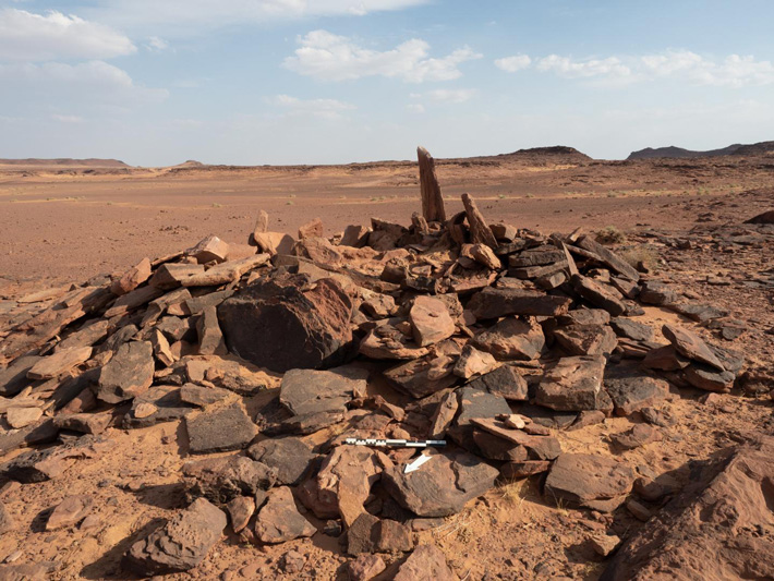
According to a statement released by Taylor & Francis, the remains of a dog and 11 people have been found in a monumental tomb near the archaeological site of Al-Ula, which is located in northwestern Saudi Arabia.
The discovery came from one of the projects in the large-scale archaeological surveys and excavations of the region commissioned by the Royal Commission for AlUla (RCU).
The researchers found the dog’s bones in a burial site that is one of the earliest monumental tombs identified in the Arabian Peninsula, roughly contemporary with such tombs already dated further north in the Levant.
This burial site in a badlands area of AlUla in north-west Saudi Arabia is currently rare for Neolithic-Chalcolithic Arabia in being built above-ground and meant to be visually prominent.
Evidence shows the earliest use of the tomb was circa 4300 BCE and received burials for at least 600 years during the Neolithic-Chalcolithic era – an indication that the inhabitants may have had a shared memory of people, places, and the connection between them.
“What we are finding will revolutionize how we view periods like the Neolithic in the Middle East. To have that kind of memory, that people may have known for hundreds of years where their kin was buried – that’s unheard of in this period in this region,” said Melissa Kennedy, assistant director of the Aerial Archaeology in the Kingdom of Saudi Arabia (AAKSAU) – AlUla project.
“AlUla is at a point where we’re going to begin to realize how important it was to the development of mankind across the Middle East,” said the AAKSAU director, Hugh Thomas.
This is the earliest evidence of a domesticated dog in the Arabian Peninsula by a margin of circa 1,000 years.
The findings are published in the Journal of Field Archaeology.
The project team, with Saudi and international members, focused its efforts on two above-ground burial sites dating to the 5th and 4th millennia BCE and located 130 kilometers apart, one in volcanic uplands and the other in arid badlands. The sites were above ground, which is unique for that period of Arabian history, and were positioned for maximum visibility.
The research team detected the sites by using satellite imagery and then by aerial photography from a helicopter. Ground fieldwork began in late 2018.
It was in the volcanic uplands site that 26 fragments of a single dog’s bones were found, alongside bones from 11 humans – six adults, an adolescent, and four children.
The dog’s bones showed signs of arthritis, which suggests the animal lived with the humans into its middle or old age. After assembling the bones, the team then had to determine that they were from a dog and not from a similar animal such as a desert wolf.
The team’s zooarchaeologist, Laura Strolin, was able to show it was indeed a dog by analyzing one bone in particular, from the animal’s left front leg. The breadth of this bone was 21.0 mm, which is in the range of other ancient Middle Eastern dogs. In comparison, the wolves of that time and place had a breadth of 24.7 to 26 mm for the same bone.
The dog’s bones were dated between circa 4200 and 4000 BCE.
Rock art found in the region indicates that the Neolithic inhabitants used dogs when hunting ibex, and other animals.
The fieldwork uncovered other noteworthy artifacts, including a leaf-shaped mother-of-pearl pendant at the volcanic uplands site and a carnelian bead found at the arid badlands site.
The researchers expect more findings in the future as a result of the massive survey from the air and on the ground, and multiple targeted excavations in the AlUla region undertaken by the AAKSAU and other teams, which are operating under the auspices of the Royal Commission for AlUla (RCU). The AAKSAU team is led by researchers from the University of Western Australia in Perth, Australia.
The researchers note that AlUla is a largely unexplored area located in a part of the world that has a fertile archaeological heritage of recognized global value.
“This article from RCU’s work at AlUla establishes benchmarks. There is much more to come as we reveal the depth and breadth of the area’s archaeological heritage,” said Rebecca Foote, Director of Archaeology and Cultural Heritage Research for RCU.
Late Roman Era Sarcophagus Found By Turkish Farmer
A project in Turkey to stop illegal excavations has resulted in the discovery of rare sarcophagi. To detect the looters, the authorities used the new surveillance technologies, which in turn led to these unexpected discoveries.
The findings are related to Aphrodisias and may have originated from a part of the ancient city that was previously unknown.
Turkish authorities have been notified of possible illegal excavations in Karacasu, a town near Aphrodisias, a Hellenistic-era city and a UNESCO World Heritage Site, in western Turkey.
After being tipped off about suspicious activity, Turkish authorities conducted surveillance which led to the impressive discovery of an illegal dig which had unearthed the sarcophagi in Turkey.
Officials decided to monitor the activities of the looters by setting up motion-sensitive cameras to detect any possible criminal activity. Drones were also employed as part of the operation.
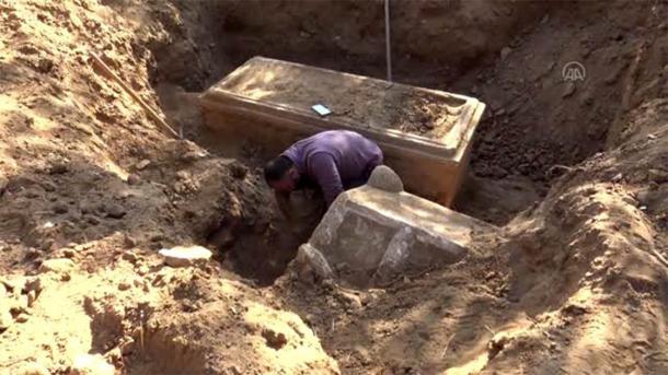
After weeks of surveillance, a group of men was detected in the area. The local gendarmerie investigated and uncovered signs of an illegal excavation in an olive grove. Further investigations revealed a half-unearthed sarcophagus.
The authorities immediately placed the site under their protection. Further investigations also revealed another sarcophagus and an altar.
The district governor Ahmet Soley is quoted by Archaeology News Network as saying that groups of people were coming from elsewhere and were engaging in suspicious activity. “As a result of the gendarme’s work, the places to be excavated were found and two sarcophagi, along with an altar, were discovered in the area.”
However, the treasure hunters behind the illegal excavation got away. Greece in High Definition reports Soley as saying that “the perpetrators of the illegal diggings are still unclear.”
One of the sarcophagi is better preserved than the other and still has many of its original decorations. According to Greece in High Definition, the Provincial Culture and Tourism Director Umut Tuncer announced that “there is a Medusa relief among others that have not yet been identified on one of the sarcophagi.” The identity of the person who was buried in this tomb has not been established.
Authorities excavating one of the impressive sarcophagi discovered near Karacasu in western Turkey.
Given the size of the sarcophagus, it is likely that the person interred was a member of the local elite. Tuncer is quoted by Archaeology News Network as explaining that the authorities believe that “the person in this sarcophagus was an important figure of the region.” It is estimated that the burials date back to at least 2,300 years ago to the Hellenistic era.
The finds are probably connected to the city of Aphrodisias, an ancient Greek City named after the Goddess of Love, Aphrodite.
The city grew wealthy because of its rich agricultural hinterland. Aphrodisias was also famed for its marble and its school of sculptors.
The city became part of the Roman province of Caria and it was favored by Sulla and Julius Caesar. As a result, it was largely autonomous. The city’s name after the rise of Christianity was “changed to Stavropolis and then Caria, and it became the seat of the metropolitan bishop of Caria,” explains an entry in the Encyclopaedia Britannica.
It went into decline and was abandoned during the Seljuk Turk invasions of Anatolia in the Middle Ages.
The discovery of the sarcophagus means that it is likely that other burials could be found. But that’s not all! Experts also believe that the sarcophagus has revealed a new part of the city. This could mean that even more important finds and long-lost structures could be recovered at a future date.
The remains of the city of Aphrodisias are now part of an archaeology park, the centerpiece of which is the remains of a temple of Aphrodite. Thanks to its UNESCO designation, the park is very popular with tourists which has become increasingly important for the local economy.
The unexpected find has created excitement amongst local authorities as “the discovery of a new metropolitan area creates great potential in terms of regional tourism,” highlights Tuncer in Archaeology News Network.
The thrilling discoveries demonstrate the threat posed by illegal excavations and how technology can play a critical role in the prevention of this crime.
Archaeologists discover a secret Aztec tunnel built 600 years ago by emperor Moctezuma
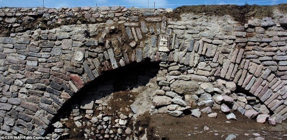
Archaeologists from the National Institute of Anthropology and History (INAH) discovered 11 pre-Hispanic images in a tunnel in Ecatepec, México’s state capital, that is part of a colonial dike system.
Petroglyphs and stucco relief panels were among the photos found on the sides of the 8.4-meter-long tunnel, according to INAH.
The tunnel is part of the Albarradón de Ecatepec, a four-kilometer-long 17th-century dike system.
Archaeologists have unearthed a secret Aztec tunnel chamber that has been hiding under the bustling streets of Mexico City for more than 600 years
A war shield, the head of a bird of prey, and a “paper ornament” are among the images carved into the walls of the tunnels while a teocalli, or temple, is etched into the central stone of the arch entrance.
The temple is dedicated to the rain god Tláloc, the INAH archaeologists concluded.
Some of the images are still being studied to determine their exact nature and meaning.
Raúl García, coordinator of a project to preserve the archaeological treasures of the dike system, said that one hypothesis is that the images were made by indigenous people who lived in the pre-Hispanic towns of Ecatepec and Chiconautla. Residents of both towns worked on the construction of the dike, he said.
Adorned with carvings and paintings, the passageway that dates back to the 15th century is believed to have been built by Emperor Montezuma I and linked to the god of water and fertility – Tlaloc
The archaeologist explained that the tunnel where the images were discovered is in a section of the dike known as the Patio de Diligencias.
The glyphs and stucco panels, all of which have been damaged by hundreds of years of rain, will be covered for protection, García said.
The Albarradón de Ecatepec was declared a historical monument in 2001 and will soon be incorporated into a public park.
México state INAH director Antonio Huitrón said the opening of the park will allow people to enjoy the “cultural heritage to which they are heirs.”
The tunnel where the images were discovered will also be open to the public although the originals won’t be on display.
The site in which the wall was found is part of a more than decade long conservation project around la Calzada de San Cristobal
Aztecs were famous for their agriculture, introducing irrigation, draining swamps, creating artificial islands in the lakes and building intricate structures like
Huitrón said the stones featuring the petroglyphs and stucco panels will be removed and transferred to the Casa Morelos Community Center in Ecatepec. Stones with replicas of the images will be installed in their place, he explained.
Ecatepec, Mexico’s second most populous municipality, is located just north of Mexico City and is part of the Valley of Mexico metropolitan area.
Research uncovers how Christianity changed Anglo-Saxon burial practices
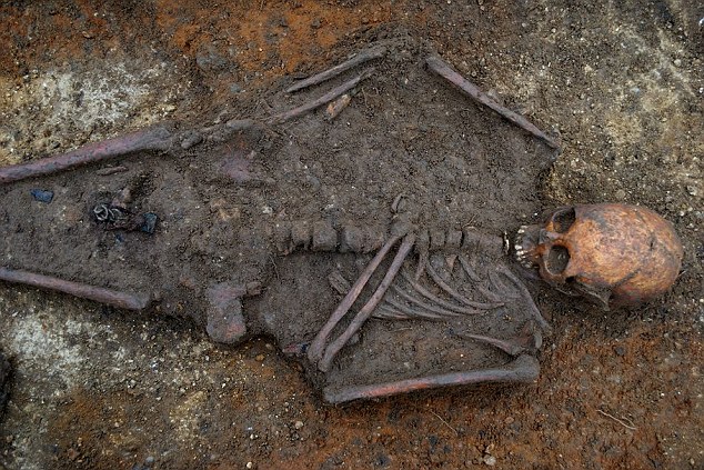
In a field three miles south of Cambridge, the bones of a mysterious Anglo-Saxon princess who died thirteen and a half centuries ago have been discovered. She died at the age of 16 and was buried with a small solid gold Christian cross encrusted with garnets on her chest, lying on a special high-status funerary bed.
The skeleton and a Christian cross were found in Trumpington Meadows, Cambs a site that has been confirmed as one of the UK’s earliest Christian burial sites.
Her true identity has yet to be revealed. However, she was most likely a member of one of the period’s newly Christianized Anglo-Saxon royal families.
She was buried fully clothed, her bronze and iron chatelaine (belt hook) and purse, still attached to her leather belt.
A clue to the circumstances of her death is the presence of three other individuals buried in separate graves alongside her (two women aged around 20 and one other slightly older individuals of indeterminate sex, but conceivably female).
Skeleton of an Anglo-Saxon teenager who was buried with the Trumpington Cross.
It’s likely that they died at the same time – probably from some sort of epidemic. Significantly, the Anglo-Saxon Chronicle mentions that England was devastated by the plague in 664 AD (around the very time that the archaeological evidence also suggests they died).
The archaeological investigation – carried out by Cambridge University Archaeological Unit – has also revealed that they were interred adjacent to a high-status settlement consisting of a 12-meter long timber hall and at least half a dozen other buildings with substantial semi-subterranean storage cellars.
Among the finds unearthed were fragments of posh French-originating shiny black ceramic wine jugs – in England a type of pottery previously found mainly on monastic sites.
The female graves, the high-status nature of the site, and the Christian burial rite all combine to suggest that the princess and her companions may well have been nuns – and that the settlement may have been part of a nunnery.
It’s known that the various newly Christianized Anglo-Saxon monarchs of the time competed with each other to establish monasteries and nunneries as proof of their Christian piety. Indeed it’s conceivable that the princess’s parents enrolled their daughter in such a nunnery to further demonstrate their commitment to their new faith (a common practice at the time).
The area itself probably enjoyed some sort of royal or otherwise elevated status inherited from Roman and immediately post-Roman times when it formed part of a native Romano-British territory centered on Cambridge and known as the Granta Saete – the territory (saete) of the River Granta (now more often known as the Cam).
Just 500 meters to the north of the princess’s grave in the village of Grantchester (derived from the ‘Granta Saete’ territorial name) – the site of what was once a substantial Roman villa, the owners of which conceivably became the area’s ruling family.
Historians believe that the Roman villa, the high-status Anglo-Saxon settlement, and the princess’s grave were in one of several quasi-independent mini-kingdoms which acted as buffer states between the larger kingdoms of East Anglia and Mercia (central England).
The princess may well, therefore, have been the daughter of a mid-7th-century king of Mercia or East Anglia or of one of the buffer states in between.
Continuing scientific investigations over the next few months are expected to reveal more information about the princess, her companions, and the site as a whole. Isotopic tests are likely to reveal their geographical origins by demonstrating where they had spent their early childhoods.
Other isotopic analyses will reveal their diet. Efforts will also be made to reconstruct aspects of the princess’s clothing from fragments of mineralized textile which survived in her grave.
“This is an incredibly important and exciting discovery which is already shedding remarkable new light on the early years of English Christianity,” said Alison Dickens, a senior manager at the Cambridge University Archaeological Unit.
The excavation carried out near the village of Trumpington, south of Cambridge, and the ongoing scientific investigations, have been funded by the Trumpington Meadows Land Company – a joint housing development venture between London’s Grosvenor property company and USS, the UK-wide universities pension scheme.