The Mosaics of Piazza Armerina: The Villa Romana Del Casale
This wonderful ancient Roman site near the town of Piazza Armerina was entirely off my radar and is the kind of spot that you will easily overlook without noticing it. But if you may, you really need to visit Villa Romana del Casale, since it is one of the best-preserved Roman ruins I have ever seen.
Villa Romana, rightly a UNESCO World Heritage Site, is most renowned for its incredible mosaics. Now, you could be saying, “So what, I’ve seen ancient mosaics before, and usually they’re not that complete or impressive.” But I’m telling you, the mosaics here are going to blow away your expectations. I’m wary of over-hyping this attraction, so hopefully, the rest of this article will show you why you need to visit.
History of Villa Romana del Casale
With any historical attraction like this, you have to acknowledge its history to truly appreciate it. Although today found right outside Piazza Armerina Villa Romana del Casale predates the small city by many centuries. Built-in the 4th century AD, the villa replaced a smaller rustic residence from the 3rd century. Historians believe that a member of the Roman provincial aristocracy, possibly a governor, owned the villa at this time.

Following the fall of the Roman Empire, the villa was fortified in the 5-6th century AD. In later centuries, it grew to become a large medieval settlement, until its people abandoned it in the 13th century. In around the 15th century, a small community known as Casale was founded here over the now-forgotten ruins. The ruins were then essentially lost to time until the 19th-20th century when people started to discover the treasure trove beneath.
More and more of the ancient villa was uncovered by excavations in the 40s, 50s and 60s. It was only a matter of time before UNESCO declared it a Worth Heritage Site in 1997. Since 2004, those responsible for the sight have undertaken major recovery work to preserve the site and its incredible mosaics.
The Villa Romana Mosaics

Although there are quite a few elements to Villa Romana, the mosaics are easily the most noteworthy. I will touch on the other parts of the ruins a little later, but if I’m honest, they’re greatly overshadowed by the mosaics. Seeing the ruined outline of an ancient Roman villa is a rare thing, but to see room after room of that villa covered in intact mosaics is another thing entirely.
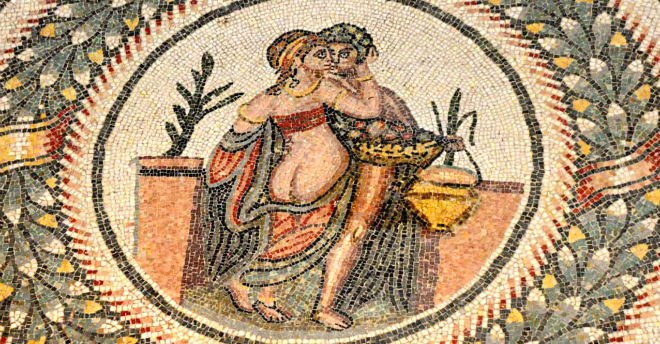
And it’s not like it’s the same mosaic patterns over and over. There’s an incredible variety of designs here, from mosaics with scenes related to a particular theme to beautiful geometric patterns. While the geometric patterns are nice enough, I personally enjoyed the thematic ones as they had a story or idea behind them.
Understanding the Mosaics

Some mosaics are centred around a theme like the seasons, showing you how that concept was perceived at the time. Others relayed an aspect of life at the time, such as women competing in athletic sports. Then there are the ones recounting a local legend or story from mythology, like the tale of Orpheus and the labours of Hercules. Imagine having a story from Roman mythology sprawled across your floor.
Because you’ll see these mosaics in most of the villa’s rooms. They decorated the floors of important halls, but also bedrooms and even regular service rooms and side rooms. That seems a little extravagant for the servant’s quarters or your pantry, but apparently not for them.
By the way, you do learn about each room, its purpose and design throughout your tour of the villa. As you go there are information boards that identify the themes and characters of the mosaic. They also often point out subtle symbolic or figurative elements that show the level of thought and detail that went into the mosaic design. With that understanding, you appreciate what you’re seeing even more.
Peristyle Courtyard

While there are a few fragments of mosaics in the entrance to the villa, it’s the peristyle where you first get a real sense of the mosaics here. The peristyle is basically a central courtyard for the villa, with a portico surrounding a garden and fountain. What makes the peristyle special is that the walkways around the outside are covered in mosaics, most of which are nearly complete. That said, there’s also the ornately carved columns and even fragments of frescoes on the walls.
The mosaics here all follow a single design, that of an animal surrounded by a wreath. There’s quite some variety in the animals depicted, but also in the colours used. To see the mosaics, visitors walk on elevated walkways that really help give you a sense of the scale here. What’s more, the walkways bring you across to the rooms off the peristyle, many of which have their own unique mosaics inside.
Ambulatory of the Big Hunt
At this point in the visit, it’s hard to imagine anyone spot being a clear highlight. But then you come to the Ambulatory of the Big Hunt and it becomes clear that this is the highlight. You may have seen lots and lots of mosaics so far, but none quite like.
That’s because the Ambulatory of the Big Hunt is one continuous corridor mosaic that runs 60 metres from one side of the villa to the other. The scale of this mosaic is unbelievable, but the fact that it creates such a comprehensive scene is even more remarkable.
The ambulatory tells the story of the Roman Venatio, where wild animals were fought in amphitheatres for the purposes of entertainment, broken down into distinct episodes.

As you move from one side of the Ambulatory to the other, you follow the story of the Venatio. First, you see scenes of how wild animals were captured from across the Roman Empire. The size of the Roman Empire means that the scene includes quite an exotic range of creatures, from lions and rhinoceroses, but also mythical ones like griffins. Then, the scenes show the animals transported across the seas back to Rome. Once you understand the theme it’s amazing how clear the meaning is behind each episode.
Other Ruins of the Villa
Having talked about the mosaics to death, let’s take a quick look at the other things to see here. You’ll encounter other parts of the villa both before and after the mosaics, with the Roman baths and the Basilica the two most memorable. Admittedly, Roman baths with each of the different temperature rooms are fairly common at archaeological excavations. But I did like how you can see they heat each of the rooms with the cutaway floor inside.
Then there’s the Basilica, the largest and most important room of the villa, which hosted the court. Although it too has some mosaics to look at, what makes the Basilica special is its rare polychrome marble surfaces. The different marble used originates across the Mediterranean and its liberal use for the floors and walls highlights just how important this stately hall was.