Traces of Possible Neolithic Tsunami Found in Israel

Traces of Possible Neolithic Tsunami Found in Israel

Prehistoric tsunami disasters had a significant impact on coastal societies,” said lead author Dr Gilad Shtienberg from the Department of Anthropology at the University of California, San Diego, and colleagues at the Scripps Center for Marine Archaeology.”

“6,000 years of historical records and geological data show that tsunamis are a common phenomenon affecting the eastern Mediterranean coastline, occurring at a rate of around 8 events per century in the Aegean region over the past 2,000 years and approximately 10 per century over the past 3,000 years in the Levant basin.”

“Most of these events are small and have only local impacts.”

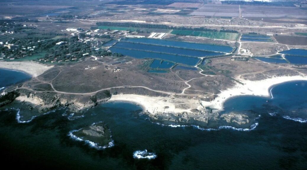
In the study, the researchers found a large paleo-tsunami deposit (between 9,910 to 9,290 years ago) at the archaeological site of Tel Dor in northwest Israel.

“Tel Dor, located along the Carmel coast of northwest Israel, is a maritime city-mound that has been occupied from the Middle Bronze II period (2000 to 1550 BCE) throughout the Roman period (3rd century CE) while Byzantine and Crusader remains are also found on the tel,” they said.

“The local environment of Dor is characterized by a series of unique embayments/pocket beaches that stand out from the linear morphology of the southeastern Mediterranean littoral shoreface.”

To conduct their analysis, the scientists used photogrammetric remote sensing techniques to create a digital model of the Tel Dor site, combined with underwater excavation and terrestrial borehole drilling to a depth of 9 m (29.5 feet).

In their samples, they found an abrupt layer of seashells and sand, dated to between 9,910 and 9,290 years ago, in the middle wetland layers deposited 15,000 to 7,800 years ago.

They estimate that the ancient tsunami had a run-up of at least 16 m and travelled between 3.5 to 1.5 km inland from the paleo-coastline.

The near absence of Pre-Pottery Neolithic A-B archaeological sites (11,700-9,800 years ago) suggest these sites were removed by the tsunami, whereas younger, late Pre-Pottery Neolithic B-C (9,250-8,350 years ago) and later Pottery-Neolithic sites (8,250-7,800 years ago) indicate resettlement following the event.

“We can’t know for sure why people weren’t living there, in a place otherwise abundant with evidence of early human habitation and the beginnings of village life in the Holy Land,” said Professor Thomas Levy, a researcher in the Department of Anthropology and the Levant and Cyber-Archaeology Laboratory in the Scripps Center for Marine Archaeology at the University of California, San Diego.

“Was the environment too altered to support life? Was the tsunami part of their cultural knowledge — did they tell stories of this destructive event and stay away? We can only imagine.”

“Our project focuses on reconstructing ancient climate and environmental change over the past 12,000 years along the Israeli coast, and we never dreamed of finding evidence of a prehistoric tsunami in Israel,” Dr Shtienberg said.

“Scholars know that at the beginning of the Neolithic, around 10,000 years ago, the seashore was 4 km (2.5 miles) from where it is today.”

“When we cut the cores open in San Diego and started seeing a marine shell layer embedded in the dry Neolithic landscape, we knew we hit the jackpot.”

Mosaics From The Roman Era Were Just Uncovered In Lebanon

Mosaics From The Roman Era Were Just Uncovered In Lebanon

Arab News reports that a six-foot section of Roman mosaic dated to between 60 B.C. and A.D. 300 was uncovered in the city of Baalbek, which is located in eastern Lebanon, during work to install sewage pipes.

The two-meter-long artefact was uncovered under a municipality building by a team of workers from the Lebanese Organization for Studies and Training who were carrying out excavations to extend a drainage network.

A technical team from the Directorate General of Antiquities in Baalbek protected the coloured mosaic with sand and special geotextile covering.

City Mayor Fouad Blog said: “Baalbek is one of the most important cities in Lebanon and, indeed, the world because of its archaeological monuments and riches dating back to the Phoenician, Roman, Greek, Byzantine, Arabic and Islamic eras.”

He called on state authorities “to give Baalbek more care and attention, and to meet our vision with a strategic plan to search for lost treasures, and highlight the cultural, human and civilizational value of the city.”

Baalbek was famous throughout the ages due to its location at the intersection of several major trading routes.

The Romans built huge temples, the ruins of which are still perched on the edge of the city after an earthquake around 600 A.D. destroyed many landmarks. The Temple of Jupiter, one of the most imposing Roman sites, has only six of its original 54 columns remaining.

Dr Jaafar Fadlallah, professor of archaeology, told Arab News: “The Lebanese should not be surprised by the antiquities that can be found in Baalbek.

The extent of the ancient city is not known yet. No one knows where the graveyards of that era are located.”

He added: “The coloured mosaic found on Tuesday indicates that the place was a huge hall within a Roman palace. Roman Baalbek was inhabited by many emperors, and it is rich with the distinctive architecture that surrounded the ancient temples.”

Fadlallah said that during the second half of the 20th century, the Department of Antiquities failed to stop people from building on land that could be rich in antiquities.

During the civil war in the 1970s, people built on archaeological sites in violation of the law. Any excavation work “could reveal buried monuments,” he added.

Archaeologists uncover ancient street food shop in Pompeii

Archaeologists uncover ancient street food shop in Pompeii

Archaeologists in Pompeii, the city buried in a volcanic eruption in 79 AD, have made the extraordinary find of a frescoed hot food and drinks shop that served up the ancient equivalent of street food to Roman passersby.

Known as a termopolium, Latin for hot drinks counter, the shop was discovered in the archaeological park’s Regio V site, which is not yet open the public, and unveiled on Saturday.

Traces of nearly 2,000-year-old food were found in some of the deep terra cotta jars containing hot food which the shop keeper lowered into a counter with circular holes.

Frescoes on an ancient counter discovered during excavations in Pompeii, Italy.

The front of the counter was decorated with brightly coloured frescoes, some depicting animals that were part of the ingredients in the food sold, such as a chicken and two ducks hanging upside down.

“This is an extraordinary find. It’s the first time we are excavating an entire termopolium,” said Massimo Ossana, director of the Pompeii archaeological park.

Archaeologists also found a decorated bronze drinking bowl known as a patera, ceramic jars used for cooking stews and soups, wine flasks and amphora.

Pompeii, 23 km southeast of Naples, was home to about 13,000 people when it was buried under ash, pumice pebbles and dust as it endured the force of an eruption equivalent to many atomic bombs.

“Our preliminary analyses show that the figures drawn on the front of the counter, represent, at least in part, the food and drink that were sold there,” said Valeria Amoretti, a site anthropologist.

Amoretti said traces of pork, fish, snails and beef had been found in the containers, a discovery she called a “testimony to the great variety of animal products used to prepare dishes”.

About two-thirds of the 66-hectare (165-acre) ancient town has been uncovered. The ruins were not discovered until the 16th century and organised excavations began about 1750.

Rare documentation of Greco-Roman life, Pompeii is one of Italy’s most popular attractions and a UNESCO World Heritage Site.

10,800 Years Ago, Early Humans Planted Forest Islands in Amazonia’s Grasslands

10,800 Years Ago, Early Humans Planted Forest Islands in Amazonia’s Grasslands

Thousands of artificial forest islands were built by Amazon’s earliest human settlers as they tamed wild plants to produce food, a new study reveals.

The discovery of the mounds is the latest evidence to show the extensive impact people had on the area. From their arrival 10,000 years ago they transformed the landscape when they began cultivating manioc and squash.

This led to the creation of 4,700 of the forest islands in what is now Llanos de Moxos in northern Bolivia, the team has found.

10,800 Years Ago, Early Humans Planted Forest Islands in Amazonia's Grasslands
An aerial shot of the Llanos de Moxos region in South America shows the strangely isolated mounds of trees that grow among expansive grasslands. Scientists’ explanation for these islands: Ancient humans planted and cultivated crops, making them some of the oldest domesticated plants in history.

This savannah area floods from December to March and is extremely dry from July to October, but the mounds remain above the water level during the rainy season allowing trees to grow on them.

The mounds promoted landscape diversity, and show that small-scale communities began to shape the Amazon 8,000 years earlier than previously thought.

The research confirms this part of the Amazon is one of the earliest centres of plant domestication in the world.

Using microscopic plant silica bodies, called phytoliths, found well preserved in tropical forests, experts have documented the earliest evidence found in the Amazon of manioc -10,350 years ago, squash — 10,250 years ago, and maize — 6,850 years ago.

The plants grown on the forest islands were chosen because they were carbohydrate-rich and easy to cook, and they probably provided a considerable part of the calories consumed by the first inhabitants of the region, supplemented by fish and some meat.

The study, in the journal Nature, was conducted by Umberto Lombardo and Heinz Veit from the University of Bern, Jose Iriarte and Lautaro Hilbert from the University of Exeter, Javier Ruiz-Pérez from Pompeu Fabra University and José Capriles from Pennsylvania State University.

Umberto Lombardo, from the University of Bern, who is one of the researches involved in the study, sampling sediment cores in the Llanos de Moxos savannah.

The study involved an unprecedented large scale regional analysis of 61 archaeological sites, identified by remote sensing, now patches of forest surrounded by savannah. Samples were retrieved from 30 forest islands and archaeological excavations carried out in four of them.

Dr Lombardo said: “Archaeologists, geographers, and biologists have argued for many years that southwestern Amazonia was a probable centre of early plant domestication because many important cultivars like manioc, squash, peanuts and some varieties of chilli pepper and beans are genetically very close to wild plants living here.

However, until this recent study, the scientist had neither searched for nor excavated, old archaeological sites in this region that might document the pre-Columbian domestication of these globally important crops.”

Professor Iriarte said: “Genetic and archaeological evidence suggests there were at least four areas of the world where humans domesticated plants around 11,000 years ago, two in the Old World and two in the New World. This research helps us to prove South West Amazonia is likely the fifth.

“The evidence we have found shows the earliest inhabitants of the area were not just tropical hunter-gatherers, but colonizers who cultivated plants. This opens the door to suggest that they already ate a mixed diet when they arrived in the region.”

Forest islands are seen from above

Javier Ruiz-Pérez said: “Through an extensive archaeological survey including excavations and after analysing dozens of radiocarbon dates and phytolith samples, we demonstrated that pre-Columbian peoples adapted to and modified the seasonally flooded savannahs of south-western Amazonia by building thousands of mounds where to settle and by cultivating and even domesticating plants since the beginning of the Holocene.”

12-year-old boy finds 69 million-year-old dinosaur fossil during a hike with his dad

12-year-old boy finds 69 million-year-old dinosaur fossil during a hike with his dad

For as long as he can recall, Nathan Hrushkin had decided to be a palaeontologist, and the 12-year-old had already made a major discovery. When exploring with his dad this summer at a protected site in the Horseshoe Canyon in the Badlands of Alberta, Canada, he uncovered a partly uncovered dinosaur fossil.

12-year-old boy finds 69 million-year-old dinosaur fossil during a hike with his dad
A 12-year-old boy made the discovery of his lifetime when he found a dinosaur skeleton dating back 69 million years.

It’s incredible to find something that’s real, like the real discovery of a fossil, like an actual dinosaur discovery,” “It’s kind of been my dream for a while.”

Nathan is a seventh-grader in Calgary, which is about an hour-and-a-half away. The fossil was a humerus bone from the arm of a juvenile hadrosaur — a duck-billed dinosaur that lived about 69 million years ago, according to a news release from the Nature Conservancy of Canada.

Nathan and his dad, Dion, had found bone fragments in the area on a previous hike and thought that they might have washed down from farther up the hill.

They were just finishing lunch when Nathan climbed up the hill to take a look.

“He called down to me, he’s like, ‘Dad, you need to get up here,’ and as soon as he said that I could tell by the tone in his voice that he found something,” Dion Hrushkin said.

“They looked like bones made of stone – you could not mistake them for anything else,” his father, Dion Hrushkin, said.

Nathan said the fossil was very obvious and it looked like “a scene on a TV show or a cartoon or something.”

They sent pictures of the bone to the Royal Tyrrell Museum of Paleontology, which identified the fossil and sent a team of palaeontologists to the site.

Fossils are protected by law in Alberta, and the NCC said that it is important that people don’t disturb any fossils they may find.
The crew has been working at the site for about two months and uncovered between 30 and 50 bones that came from a single young hadrosaur that was about three or four years old, according to the statement.

Hadrosaur bones are the most common fossils found in Alberta’s badlands, but few juvenile skeletons have been found, the statement said. It was also found in a layer of rock that rarely preserves fossils.

“This young hadrosaur is a very important discovery because it comes from a time interval for which we know very little about what kind of dinosaurs or animals lived in Alberta,” François Therrien, the Royal Tyrrell Museum’s curator of dinosaur palaeoecology, said in the statement. “Nathan and Dion’s find will help us fill this big gap in our knowledge of dinosaur evolution.”

The fossils were very close together, so the palaeontologists removed large pieces of the surrounding rock from the canyon walls.

The bones were then covered in a protective jacket of burlap and plaster, so they could be taken to the museum for cleanup and further study.

One of the fossil-rich slabs weighed about 1,000 pounds and was more than four feet wide, according to Carys Richards, a communications manager with the NCC.

Nathan had heard of the hadrosaur before his big find but said it wasn’t the most well-known dinosaur. It’s probably his favourite now — beating out the wildly popular Tyrannosaurus rex.

Nathan and his dad have come to watch the dig several times since the discovery and were there on Thursday when the team was hauling out the last specimens.

“It was pretty fun to be there and watch them do their things,” Nathan said.

57,000-Year-Old Wolf Pup Mummy Uncovered in Canadian Permafrost

57,000-Year-Old Wolf Pup Mummy Uncovered in Canadian Permafrost

In Yukon, Canada, a perfectly preserved wolf puppy, hidden away for 57,000 years in permafrost and identified by researchers as “the oldest, most complete wolf,” has been discovered in Yukon, Canada.

At the Klondike goldfields, near Dawson City, a miner had seen something in the frozen mud wall, and he had to blast through it to get to it to see what it was. He found a creature that was named the Zhùr by the local Tr’ondëk Hwëch’in First Nation people.

Julie Meachen, an associate professor of anatomy at Des Moines University in Iowa, told CNN, “This mummy is so complete, she has basically got all her skin, most of her fur … all her soft tissues present, and she’s 56,000 years old.

57,000-Year-Old Wolf Pup Mummy Uncovered in Canadian Permafrost
This photo shows a closeup of the wolf pup’s head, showing her teeth.

The female pup, according to Meachen, is “the oldest, most complete wolf that’s ever been found,” allowing researchers to delve deeper into what her life would have looked like.

Using X-ray techniques, experts determined that the puppy, which had been preserved in permafrost, died at 6 or 7 weeks old.

Meanwhile, a technique called stable isotope analysis revealed that the animal lived during a time when glaciers had receded.

This photo shows an x-ray view of the wolf pup.

“There weren’t quite as many glaciers around, which means there was a lot more freshwater,” she said. “There were a lot of streams, a lot of rivers flowing, and probably a lot of other animals around. She lived in a lush time.”

The wolf cub’s diet, researchers found, was influenced by her proximity to water: Isotope analysis revealed “she and her mom were eating mostly aquatic resources — things like salmon, maybe some shorebirds,” Meachen said.

DNA analysis revealed the pup is descended from ancient wolves — the ancestors of modern wolves — from Russia, Siberia and Alaska.

This photo shows the wolf pup as she was found

“It’s not a surprise — she is related to the things that were there at the time,” she explained. “But the cool thing about that, that most people might not know, is that wolves in the ice age were only distantly related to wolves that are around today.

“They are still the same species, but they are very different, for being in the same species. Their genetics have changed quite a bit over time — the diversity of wolf has been diminished over time, and again, expanded.

“She is truly an ancient wolf, and she was related to all the wolves around her at the time,” Meachen said.

It takes very specific circumstances to create a permafrost mummy, the researchers said, although several well-preserved wolf cubs have been retrieved from Siberia. However, this cub, found in North America, was particularly rare.”It’s rare to find these mummies in the Yukon.

The animal has to die in a permafrost location, where the ground is frozen all the time, and they have to get buried very quickly, like any other fossilization process,” Meachen said in a statement. “If it lays out on the frozen tundra too long it’ll decompose or get eaten.”

Because of her “pristine” condition, experts think that the wolf cub died instantaneously, perhaps when her den collapsed, as data showed she didn’t starve.

66 Roman Army Campsites Identified in Spain

66 Roman Army Campsites Identified in Spain

According to a statement released by the University of Exeter, more than 60 Roman Army camps have been identified on the Iberian Peninsula, where Roman soldiers battled local peoples in the first century B.C.

While seeking to expand their empire and procure natural resources such as tin and gold. Researchers based in Spain and the United Kingdom spotted the sites through the use of airborne laser scanning, aerial photography, and satellite images. 

Analysis of the 66 camps shows the Roman army had a larger presence in the region than previously thought during the 200-year battle to conquer the Iberian Peninsula.

66 Roman Army Campsites Identified in Spain
Roman military presence in Castile.

The discovery of camps of different sizes – used for training and shelter – has allowed experts to map how soldiers attacked indigenous groups from different directions and to learn more about the footprint of the Roman military presence in the northern fringe of the River Duero basin – the León, Palencia, Burgos and Cantabria provinces.

Experts analysed aerial photography and satellite images, created three-dimensional models of the terrain from LiDAR data and used drones to create detailed maps of the sites. This included resources from the Spanish National Geographic Institute (IGN) and geoportals such as Google Earth or Bing Maps. Pinpointing locations allowed fieldwork to then take place.

Aerial photographs of the canteen of Tintolondro (black) (A), Roman Road (white) and Canti (black) are in Quintanilla di Riofresno

These temporary occupations usually left fragile and subtle traces on the surface. The ditches or the earth and stone ramparts protecting these fortifications have been filled in and flattened. Combining different remote sensing images and fieldwork shows the perimeter shape of the temporary Roman military camps, often a rectangle like a playing card.

These new sites are located at the foothills of the Cantabrian Mountains, where the conflict between Romans and natives was focused at the end of the 1st century BC. This suggests soldiers crossed between lowlands and uplands, using ridges in the mountains to stay out of site and give themselves more protection.

The fact there were so many army camps in the region shows the immense logistical support which allowed soldiers to conquer the area. Sites were used to aid movement to remote locations and to help soldiers stay in the area over the cold winter months. Some of the camps may have housed soldiers for weeks or months, and overs overnight.

The aim of the occupation was to expand the empire and to be able to exploit natural resources such as tin and gold.

The research, published in the journal Geosciences, was carried out by Andrés Menéndez Blanco, Jesús García Sánchez from the Archaeology Institute of Mérida, José Manuel Costa-García and Víctor Vicente García from the University of Santiago de Compostela, João Fonte from the University of Exeter and David González-Álvarez from the Institute of Heritage Sciences, Spanish National Research Council.

Dr Fonte said: “We have identified so many sites because we used different types of remote sensing. Airborne laser scanning gave good results for some sites in more remote places because it showed earthworks really well. Aerial photography worked better in lowland areas for the detection of cropmarks.”

“The remains are of the temporary camps that the Roman army set up when moving through hostile territory or when carrying out manoeuveres around their permanent bases. They reveal the intense Roman activity at the entrance to the Cantabrian Mountains during the last phase of the Roman conquest of Hispania.”

There is an important concentration of 25 sites along the valleys of northern Palencia and Burgos, as well as southern Cantabria. In the province of León, as many as 41 sites have been documented in different valleys. These range from small forts of a few hundred square meters to large fortified enclosures of 15 hectares.

Most of these Roman military sites were located in close proximity of later important Roman towns. Sasamón, a village in Burgos that was probably where nearby Emperor Augusto established his camp during his presence in the front.

The research will continue so experts can examine the relationships the Romans established with indigenous communities, named Vaccaei, Turmogi, Cantabri, Astures and Callaeci, according to the Greek and Latin sources.

The team is currently developing a project to catalogue and document all the Roman camps in the province of León by means of drones, in order to gain a better understanding of their structures or the evolution of their state of conservation. Work is also continuing in Burgos and in Sasamón, including a study of the Cerro de Castarreño settlement and its conquest in the 1st century BC.

Boudicca revolt: Essex dig reveals ‘evidence of Roman reprisals’

Boudicca revolt: Essex dig reveals ‘evidence of Roman reprisals’

BBC News reports that archaeologists have found a ten-acre settlement made up of 17 roundhouses surrounded by a defensive structure that was burned down and abandoned in the late first century A.D.

Researchers think the residents of this high-status village may have participated in the revolt against the Roman invasion led by Boudicca, the queen of the Iceni tribe.

“The local Trinovantes tribe joined the A.D. 61 rebellion and after Boudicca’s defeat we know the Romans punished everyone involved,” said Andy Greef of Oxford Archaeology East.

“The local Trinovantes tribe joined the AD61 rebellion and after Boudicca’s defeat we know the Romans punished everyone involved,” said Andy Greef.

The excavation by Oxford Archaeology East ahead of a housing development by Countryside Properties began during the first lockdown and lasted eight months.

The four-hectare (10-acre) site had been little disturbed in the centuries since the Iron Age settlement was abandoned
One of the more unusual finds was this copper alloy cockerel, which is believed to have been an offering to the gods

The enclosure was “clearly an important place” with an “avenue-like entrance” and continued to expand after the Roman invasion in AD43, so archaeologists were surprised it was not resettled after its destruction.

Further evidence of the settlement’s abandonment was the complete lack of Roman burials in subsequent centuries, Mr Greef added.

Despite this, the site remained a centre of “votive offerings” – possibly linked to the cult of the Roman god Mercury – until the end of the Roman occupation in the Fourth Century AD.

Mr Greef said: “More than 100 brooches, 10 Iron Age coins, dozens of Roman coins, hairpins, beads, finger rings and a lovely copper alloy cockerel figurine were discovered.

“It could be there was a shrine on the site that continued to attract people and, as it’s very close to the Roman road Stane Street, it was easy to access.”

The dig also revealed “one of the most significant assemblages of late Iron Age pottery from Essex in recent years”.

Many months of analysis lie ahead, but once completed, it is hoped some of the finds will find homes in Essex museums.

The dig continued throughout lockdown with archaeologists observing social distancing

All In One Magazine