Archaeologists Uncover Unique 6th Century Mosaic in Abandoned Byzantine Monastery

A recent excavation report from the Israel Antiquities Authority has revealed the discovery of a well-preserved Byzantine-period monastery and farmhouse in Naḥal Peḥar, located within the modern settlement of Giv‘ot Bar, north of Beersheba.
According to excavator Nir-Shimshon Paran, “The monastery was well-preserved, attesting to the daily life of the monks in the Negev during the Byzantine period. It featured poorly executed mosaic floors, likely laid by the monks themselves.”
“Most of the finds in the monastery were uncovered on the floors, indicating its orderly abandonment in the late Byzantine or early Umayyad period (sixth to seventh centuries CE),” Paran noted. “It is possible that the monastery was abandoned during the transition to the Early Islamic period due to a deterioration in the security situation in the region.”
The monastery complex included a chapel, dining room (refectory), kitchen, service wings, and a winepress. “The main building had thickened walls, giving it the appearance of a fortified structure,” the study reported.

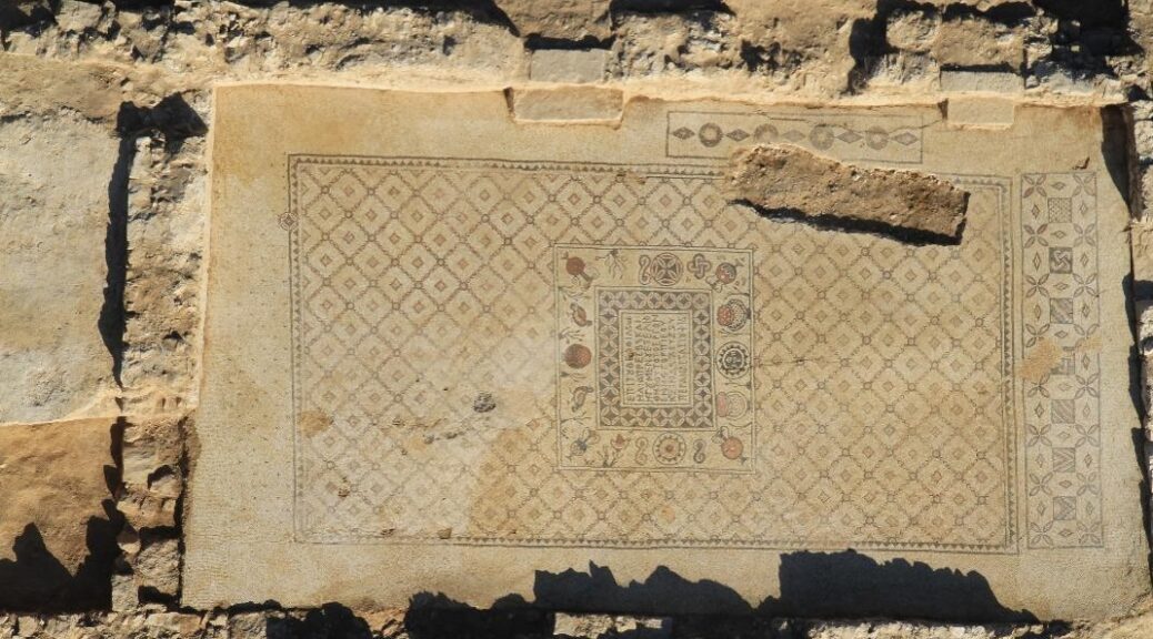
One of the most striking discoveries was a unique mosaic in the chapel: “In the center of the mosaic is a Maltese cross, and below it, within a frame, a three-line Greek inscription mentioning the monastery’s name and the names of four monks who lived there.”
Adjacent rooms contained evidence of daily life. “A cone-shaped depression in the mosaic floor likely served to hold a vessel,” Paran noted. Finds included pottery dated to 460–475 CE and a cooking pot from the end of the fifth to seventh centuries.
Two tombs were found in the stone-paved apse: “At the eastern end of the southern tomb was an engraved cross,” according to Paran. Additional items, such as a collapsed chancel-screen post, bronze hook, chains, and glass lamps, suggest that the area was used for liturgical purposes.

The kitchen was identified by an “ash layer (0.1 m thick), indicating a cooking area,” along with work tables. “Below the table, the lower half of a storage jar was sunk into the floor, likely used as a ṭabun (oven).”
The monastery also featured a wine production facility: “In the service wing’s northeastern section, a winepress treading floor (5.7 × 6.0 m) sloping to the south was discovered.” A plastered settling pit and a probable cistern were also excavated.
Inscriptions found included two epitaphs written in red-brown ink, confirming burial use.
Archaeologists uncovered a farmhouse from the same period just south of the monastery. The structure included a rectangular watchtower with a small window. A coin that was found on the floor dates to the first half of the sixth century CE.

“Both the monastery and farmhouse were one-period sites… it seems that both buildings were abandoned at the end of the Byzantine period (end of the sixth/early seventh century CE),” Paran noted.
The findings were published in ‘Atiqot (Volume 116) by the Israel Antiquities Authority. This discovery sheds light on desert monastic life in the region over 1,400 years ago, providing valuable insights into the daily lives of the monks who inhabited the area during the Byzantine era.


