5,500-Year-Old Sumerian Star Map Recorded the Impact of a Massive Asteroid

5,500-Year-Old Sumerian Star Map Recorded the Impact of a Massive Asteroid

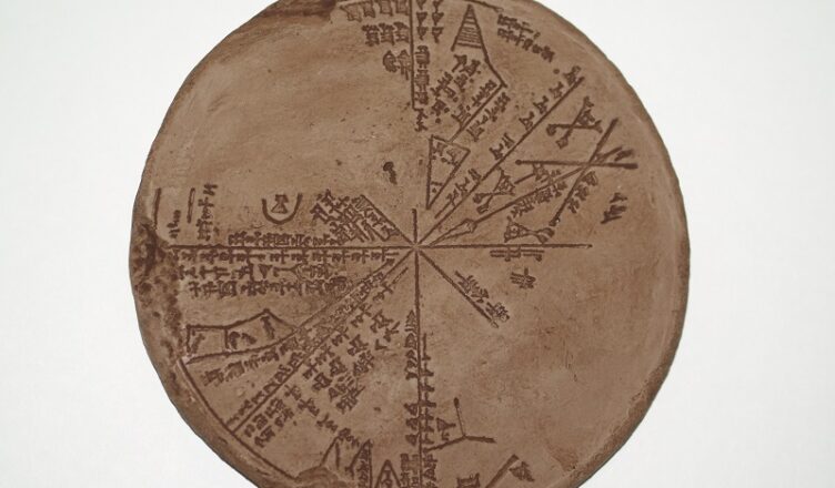
For more than 150 years scientists have tried to solve the mystery of a notorious cuneiform clay tablet that reveals that in the past the impact case of so-called Köfel was detected. The circular stone-cast tablet was discovered in the late 1800s from the 650 BC King Ashurbanipal‘s underground library in Nineveh, Iraq.

Data processing, which was long believed to be an Assyrian tablet, mirrored the sky over Mesopotamia in 3,300 BC and proved to be much more ancient Sumerian origin. The tablet is the first astronomical instrument, the “Astrolabe.”  It consists of a segmented, disk-shaped star chart with marked units of angle measure inscribed upon the rim.

Unfortunately, considerable parts of the planisphere on this tablet are missing (approximately 40%), damage which dates to the sacking of Nineveh. The reverse of the tablet is not inscribed.

Still, under study by modern scholars, the cuneiform tablet in the British Museum collection No K8538 (known as “the Planisphere”) provides extraordinary proof for the existence of sophisticated Sumerian astronomy. In 2008 two authors, Alan Bond and Mark Hempsell published a book about the tablet called “A Sumerian Observation of the Kofels’ Impact Event”.

Raising a storm in archaeological circles, they re-translated the cuneiform text and assert the tablet records an ancient asteroid strike, the Köfels’ Impact, which struck Austria sometime around 3,100 BC. The giant landslide centered at Köfels in Austria is 500m thick and five kilometers in diameter and has long been a mystery since geologists first looked at it in the 19th century.

The conclusion drawn by research in the middle 20th century was that it must be due to a very large meteor impact because of the evidence of crushing pressures and explosions. But this view lost favor as a much better understanding of impact sites developed in the late 20th century.

In the case of Köfels there is no crater, so to modern eyes it does not look as an impact site should look. However, the evidence that puzzled the earlier researchers remains unexplained by the view that it is just another landslide.

So what is the connection between the sophisticated Sumerian star chart discovered in the underground library in Nineveh and mysterious impact that took place in Austria?

Examination of the clay tablet reveals that it is an astronomical work as it has drawings of constellations on it and the text has known constellation names. It has attracted a lot of attention but in over a hundred years nobody has come up with a convincing explanation as to what it is.

With modern computer programs that can simulate trajectories and reconstruct the night sky thousands of years ago, the researchers have established what the Planisphere tablet refers to. It is a copy of the night notebook of a Sumerian astronomer as he records the events in the sky before dawn on the 29 June 3,123 BC (Julian calendar).

Half the tablet records planet positions and cloud cover, the same as any other night, but the other half of the tablet records an object large enough for its shape to be noted even though it is still in space.

The astronomers made an accurate note of its trajectory relative to the stars, which to an error better than one degree is consistent with an impact at Köfels.

The observation suggests the asteroid is over a kilometer in diameter and the original orbit about the Sun was an Aten type, a class of asteroid that orbit close to the earth, that is resonant with the Earth’s orbit.

This trajectory explains why there is no crater at Köfels. The in coming angle was very low (six degrees) and means the asteroid clipped a mountain called Gamskogel above the town of Längenfeld, 11 kilometers from Köfels, and this caused the asteroid to explode before it reached its final impact point. As it traveled down the valley it became a fireball, around five kilometers in diameter (the size of the landslide).

Around 700 BC an Assyrian scribe in the Royal Place at Nineveh made a copy of one of the most important documents in the royal collection. Two and a half thousand years later it was found by Henry Layard in the remains of the palace library. It ended up in the British Museum’s cuneiform clay tablet collection as catalogue No. K8538 (also called “the Planisphere”), where it has puzzled scholars for over a hundred and fifty years.

In this monograph, Bond and Hempsell provide the first comprehensive translation of the tablet, showing it to be a contemporary Sumerian observation of an Aten asteroid over a kilometer in diameter that impacted Köfels in Austria in the early morning of 29th June 3123 BC.

When it hit Köfels it created enormous pressures that pulverized the rock and caused the landslide but because it was no longer a solid object it did not create a classic impact crater.

Mark Hempsell, discussing the Köfels event, said: “Another conclusion can be made from the trajectory. The back plume from the explosion (the mushroom cloud) would be bent over the Mediterranean Sea re-entering the atmosphere over the Levant, Sinai, and Northern Egypt.

“The ground heating though very short would be enough to ignite any flammable material – including human hair and clothes. It is probable more people died under the plume than in the Alps due to the impact blast.”

In other words, the remarkable ancient star map shows that the Sumerians made an observation of an Aten asteroid over a kilometer in diameter that impacted Köfels in Austria in the early morning of 29th June 3123 BC.

The Yakhchāl: 2,400-Year-old Persian “refrigerator” that stored food in the desert

The Yakhchāl: 2,400-Year-old Persian “refrigerator” that stored food in the desert

Looking up inside a Yakhchal

The refrigerator is one of the most indispensable appliances of modern life. it’s almost unthinkable that a person can live with one or least have other means to keep their food refrigerated. so, imagine what if life was like during ancient times when electricity was still unheard of.

Ancients were wiser than some today belief. They had no rockets or electronics, no indisputable proof of such inventions was discovered, but they developed the technology that we don’t usually associate with the ancient world.

The yakhchal (meaning ice pit) was a type of ancient refrigerator built in the deserts of Persia (now Iran), which was made without electricity, modern coolants, or most elements of modern refrigerators. It demonstrates the ability of humans to find solutions to problems with any materials or technology they have available.

This approach to making refrigerators was mastered by Persian engineers around 400 B.C., though it is possible that people were making them before that.

Yakhchals are fairly simple to make so that even those who were relatively poor could afford them. Most yakhchals were domed structures with an underground square-shaped containment area.

Yakhchal in Yazd, Iran

After the containment area was dug and the dome was erected, a type of mortar made from clay, sand, ash, goat hair, and lime called sarooj was used to make it waterproof.

The collection area for the water needed to be deep enough to keep cool and the material out of which the yakhchal was made needed to be enough of an insulator to keep out heat.

Water was brought to the yakhchal either by directly transporting ice from nearby mountains or diverting water from an aqueduct into the yakhchal using underground water channels called qanats.

Adjacent to some yakhchals, an east-west oriented wall would be built on the south side of the refrigerator and water would be brought into the yakhchal from the north side of the wall. The reason for this was to keep the water cool during the middle of the day as it entered the yakhchal.

Another device used to keep the yakhchal cool is a badgir, a type of wind-catching mechanism which would catch the breeze and divert it down into the yakhchal.

As the air descended, it would be cooled by the ice as well as the cool air accompanying the water in the qanat. Alternatively, the badgir could be used to cause warm air to rise and cool air to replace it. This mechanism is still used in many desert towns in modern Iran.

A diagram showing how the yakhchal kept the inside refrigerated

Once in the yakhchal, the water would freeze overnight. This process could be expedited through having ice, transported from the mountains, already present in the yakhchal to act as a seed.

Once the water was frozen, it would be cut up into blocks so that the water could be easily transported out of the yakhchal for drinking and other purposes. In addition to storing drinking water, the yakhchal was also used to keep food such as fruit, dairy products, and probably meat cool so that it would last longer.

Many Yakhchals in Iran, Afghanistan, and other parts of west and central Asia are still standing even after thousands of years. They represent the remnants of ancient Persia and are a part of the cultural heritage of Iran.

A yakhchal in the Dasht-e-Kavir desert, Iran

In addition to being historically interesting, yakhchals have also been suggested as an inexpensive and sustainable way for modern Iranians and other central Asian communities to have refrigeration without requiring the use of electricity.

Theoretically, the process used to make yakhchals could also be replicated and used in other regions with climates similar to desert areas in Iran and Central Asia such as the American Southwest or parts of northwestern China. In this way, the revival of ancient technology could help modern people around the world live more sustainably and still have modern conveniences, specifically refrigeration.

Modern westerners tend to assume that conveniences like refrigeration require advanced technologies such as electricity and the ability to produce powerful coolant chemicals, but it turns out that refrigeration can be produced using surprisingly simple methods.

Inside ice house, Meybod Iran
https://www.youtube.com/watch?v=hRYuUqYI3nM
Ancient Persian Air Conditioning

Archaeology reveals how pandemics were handled in ancient African societies

Archaeology shows how ancient African societies managed pandemics

In past cultures, archaeologists have studied diseases for a long time. To do so, they consider a wide array of evidence: settlement layout, burials, funerary remains, and human skeletons.

Studying ancient African societies, like Great Zimbabwe, can reveal how communities dealt with disease and pandemics

We do not know, for example, that the damaging impact of epidemics prompted the abandonment of settlements at Akrokrowa in Ghana during the early 14th century AD. About 76 infant burial sites at an abandoned settlement that now forms part of the Mapungubwe World Heritage site in the Limpopo Valley of South Africa suggest a pandemic hit the people living there after 1000 AD.

Some of the techniques which civilizations have implemented to cope with pandemics are also described in archaeological and literary. These included burning settlements as a disinfectant and shifting settlements to new locations. Social distancing was practised by dispersing settlements.

Archaeologists’ findings at Mwenezi in southern Zimbabwe also show that it was a taboo to touch or interfere with remains of the dead, lest diseases are transmitted in this way. In the late 1960s, some members of an archaeological dig excavating 13th-century house floors in Phalaborwa, South Africa, refused to keep working after encountering burials they believed were sacred. They also worried that the burials were related to a disease outbreak.

Social distancing and isolation have become watchwords during the COVID-19 pandemic. From archaeology, we know that the same practices formed a critical part of managing pandemics in historical African societies.

In what is Zimbabwe today, the Shona people in the 17th and 18th centuries isolated those suffering from infectious diseases – such as leprosy – in temporary residential structures. This meant that very few people could come into contact with the sick. In some cases, corpses were burnt to avoid spreading the contagion.

Humans have a propensity to relax and shift priorities once calamities are over. Data collected by archaeologists, that show how indigenous knowledge systems helped ancient societies in Africa deal with the shock of illness and pandemics, can help remind policymakers of different ways to prepare modern societies for the same issues.

Social distancing and isolation

Research at the early urban settlement of K2, part of the Mapungubwe World Heritage site, has thrown significant light on ancient pandemics.

The inhabitants of K2 (which dates back to between AD1,000 and AD1,200) thrived on crop agriculture, cattle raising, metallurgy, hunting and collecting food from the forest. They had well developed local and regional economies that fed into international networks of exchange with the Indian Ocean rim. Swahili towns of East Africa acted as conduits.

Archaeological work at K2 uncovered an unusually high number of burials (94), 76 of which belonged to infants in the 0-4 age category. This translated into a mortality rate of 5%. The evidence from the site shows that the settlement was abruptly abandoned around the same time as these burials. That means a pandemic prompted the community’s decision to shift to another settlement.

Shifting to another region of Africa, archaeological work at early urban settlements in central and southern Ghana identified the impact of pandemics at places such Akrokrowa (AD950 – 1300) and Asikuma-Odoben-Brakwa in the central district of Ghana.

These settlements, like others in the Birim Valley of southern Ghana, were bounded by intricate systems of trenches and banks of earth. Evidence shows that after a couple of centuries of continuous and stable occupation, settlements were abruptly abandoned. The period of abandonment appears to coincide with the devastation of the Black Death in Europe.

Post-pandemic, houses were not rebuilt; nor did any rubbish accumulate from daily activities. Instead, the disrupted communities went to live elsewhere. Because there are no signs of long term effects – in the form of long periods of hardship, deaths or drastic socioeconomic or political changes – archaeologists believe that these communities were able to manage and adapt to the pandemic. This is different to how society has handled illness and pandemics ever since. Modern-day life allows us to accommodate to those who are in need of recovery, such as by being able to access a disability insurance guide or help from the NHS. People back then adapted in the way of fleeing the post-pandemic locations and starting again – there was no help available to let areas fight the pandemic. Instead, they found their own way.

Analysis of archaeological evidence reveals that these ancient African communities adopted various strategies to manage pandemics. These include burning settlements as a disinfectant before either reoccupying them or shifting homesteads to new locations. African indigenous knowledge systems make it clear that burning settlements or forests was an established way of managing diseases.

The layout of settlements was also important. In areas such as Zimbabwe and parts of Mozambique, for instance, settlements were dispersed to house one or two families in a space. This allowed people to stay at a distance from each other – but not too far apart to engage in daily care, support and cooperation.

While social coherence was the glue that held society together, social distancing was inbuilt, in a supportive way. Communities knew that outbreaks were unpredictable but possible, so they built their settlements in a dispersed fashion to plan ahead.

These behaviours were also augmented by diversified diets that included fruits, roots, and other things that provided nutrients and strengthened the immune system.

Africa’s past and the future of pandemics

There were multiple long-term implications of pandemics in these communities. Perhaps the most important was that people organised themselves in ways that made it easier to live with diseases, managing them and at the same time sticking to the basics such as good hygiene, sanitation and environmental control. Life did not stop because of pandemics: populations made decisions and choices to live with them.

Some of these lessons may be applied to COVID-19, guiding decisions and choices to buffer the vulnerable from the pandemic while allowing economic activity and other aspects of life to continue. There will also be more modern technologies and strategies used, such as requiring citizens to wear N95 masks. A mixture of the two seems the most sensible approach. As evidence from the past shows, social behaviour is the first line of defence against pandemics: it’s essential this be considered when planning for the latest post-pandemic future.

600-Year-Old Skeleton found beneath Edinburgh School Playground

600-Year-Old Skeleton found beneath Edinburgh School Playground

A skeleton discovered in a school playground could be that of a 600-year-old pirate, according to archaeologists. City of Edinburgh Council workers found the remains at the city’s oldest primary school while carrying out survey work to build an extension.

Victoria Primary School is close to Newhaven’s harbour, where workers had expected to find remains of the original marina but instead made the gruesome discovery.

Archaeologists have since studied the bones and initially thought they were Bronze Age because they were in such poor condition and found next to 4,000-year-old shards of pottery.

The school, pictured, is the oldest primary in Edinburgh and the discovery came as workers built an extension.
Remains were found at Victoria Primary School, Edinburgh

But during carbon dating, they were found to be from the 16th to 17th centuries.

The skeleton is believed to belong to a man in his fifties – who was probably a criminal. Six hundred years ago Newhaven dockyard was home to a gibbet – commonly used to execute witches and pirates.

Experts think the man could have been killed in the device for criminal behaviour or piracy before his body was dumped in the nearby wasteland.

The condition of his bones and his burial site close to the sea rather than in any of the nearby graveyards suggests that after his execution the man’s body was displayed insight of ships to deter other pirates.

His burial in a shallow, unmarked grave also suggests he had no relatives or friends in the area. Forensic artist Hayley Fisher, along with AOC Archaeology, has created a facial reconstruction of the pirate’s skull.

Councillor Richard Lewis, Culture Convener for the City of Edinburgh Council, said: ‘Edinburgh has an undeniably intriguing past and some of our archaeological discoveries have been in the strangest of places.

‘Thanks to carbon dating techniques, archaeologists now know that the skeleton was likely to have been a murder victim – and quite possibly a pirate.

‘It’s fantastic that through the Council’s archaeology and museums service, we are able to investigate such discoveries and add to our understanding of Newhaven’s heritage.’

Laura Thompson, Head Teacher at Victoria Primary School, said her pupils were excited about the discovery.

She said: ‘As the oldest working primary school in Edinburgh, we are proud of our history and heritage and the school even has a dedicated museum to the local area.

‘The pupils think it’s fantastic that a skeleton was found deep underneath their playground.

‘The archaeologists will hold a special lesson with some of the children about how they have used science to analyse the remains and it will be a good learning opportunity for them.’ 

60,000 Mayan structures preserved under dense Guatemalan jungle

Lasers Reveal 60,000 Ancient Maya Structures in Guatemala

Researchers have identified more than 60,000 previously unknown structures in northern Guatemala after extensive aerial LiDAR (Light Detection And Ranging) surveys.

Extensive LiDAR scans demonstrated that the region was more densely populated than previously thought

Their findings show that the region’s pre-Columbian civilization was “far more complex and interconnected than most Maya specialists had supposed,” according to National Geographic.

Scientists mapped more than 800 square miles of Guatemala’s Maya Biosphere Reserve and uncovered an extensive network of previously-unknown structures, quarries, farmland, and roads.

Based on the data, researchers believe that the region supported an advanced civilization on par with that of ancient Greece or China, rather than a series of isolated city-states.

Tulane University archaeologist Francisco Estrada-Belli says that the surveys reveal that the region was far more densely populated than previously thought: “it’s no longer unreasonable to think that there were 10 to 15 million people there,” even in areas that were thought to be uninhabitable.

Archaeologists will now study the data to refine their understandings of the region’s inhabitants. The surveys found more than just ancient structures: they found evidence of pits from modern-day looters.

LiDAR mapping has proven to be a useful tool for archaeologists in recent years, who have used the technology to penetrate the dense rainforests of South America to reveal human-made structures that have long been hidden.

The ancient Maya city of Tikal in Guatemala.
Extensive defensive systems and irrigation canals suggest a highly organised workforce.

Aircraft-mounted LiDAR sensors shoot lasers into the ground, which bounce back once they hit an object. While the lasers hit tree leaves and vegetation, they also hit the ground.

Once scientists peel back the forest canopy and underbrush, they’re left with detailed images of the ground.

Last year, author Douglas Preston detailed an expedition to Honduras in his book The Lost City of the Monkey God, where archaeologists used LiDAR to uncover a pair of ancient cities in the middle of an impenetrable rainforest.

The survey comes from The Foundation for Maya Cultural and Natural Heritage (PACUNAM), a Guatemalan nonprofit organization dedicated to historical preservation, archaeological research, environmental conservation, and sustainable economic development.

This project is just the first phase of a three-year project that’s expected to survey 5,000 square miles of the region.

According to Ars Technica, researchers on the project will be submitting their findings to papers soon, but they will be revealing some of their work in an upcoming National Geographic special.

Amateur metal detector uncovers 22,000 Roman coins

Amateur metal detector uncovers 22,000 Roman coins

An enthusiast of an East Devon metal detector has stumbled on one of Britain’s largest hoards of Roman coins ever discovered, prompting a local museum to launch a campaign to buy the “remarkable” collection for the nation.

It is the fifth-largest discovery of Roman coins in Britain, comprising approximately 22,000 coins dating back more than 1,700 years. The British Museum announced the discovery of the Seaton Down Hoard

Laurence Egerton, 51, a semi-retired builder from East Devon, discovered two ancient coins “the size of a thumbnail” buried near the surface of a field with his metal detector in November last year.

After digging deeper, his shovel came up full of the copper-alloy coins. “They just spilled out all over the field,” he said. “It was an exciting moment. I had found one or two Roman coins before but never so many together.”

The metal detectorist called in the experts and watched amazed as archaeologists discovered thousands of more coins buried about a foot deep. To ensure the site did not tamper with Mr Egerton slept in his car nearby “for three cold nights” until the dig was finished.

According to Devon County Archaeologist, Bill Horner, the Roman copper-alloy coins (pictured) date back to between AD 260 and AD 348 and bear the images of Emperor Constantine, his family, co-Emperors and immediate predecessors and successors

“It’s by far the biggest find I’ve ever had. It really doesn’t get any better. It is so important to record all of these finds properly because it is so easy to lose important insights into our history,” Mr Egerton said. He found the coins near the Honeyditches site in Devon where a Roman villa had previously been excavated.

Bill Horner, county archaeologist at Devon County Council, said: “We realised the significance and mobilised a team as fast as we could.” He continued: “The coins were in remarkably good condition. Coming out of the ground you could see the portrait faces; a family tree of the House of Constantine.”

Over the past 10 months the coins have been lightly cleaned, identified and catalogued at the British Museum, although there is still more work to do. They range from late AD 260 to almost AD 350. Mr Horner said the coins bore a range of portraits, describing it as a “family tree of the House of Constantine”.

The British Museum called the scale of the find “remarkable”, adding that it was “one of the largest hoards ever found within the whole Roman Empire”. The largest find in Britain was the Cunetio Hoard of almost 55,000 coins discovered near Mildenhall, Wiltshire in 1978

The coins would not have been particularly valuable at the time; with experts estimated they would then have been worth about four gold coins, equivalent to a worker’s pay for two years. The Royal Albert Memorial Museum & Art Gallery in Exeter hopes to raise money to buy the collection and appealed to the public to donate.

A cluster of coins that were discovered 

The hoard is yet to be fully valued, but one expert said it would be worth less than £100,000. The proceeds will be split between Mr Egerton and the landowner, Clinton Devon Estates.

One of the coins is particularly special. It marks the one millionth find of the Portable Antiquities Scheme, set up in 1997 to provide a record of all the finds brought in by members of the public. The scheme is managed by the British Museum and funded by the Department for Culture, Media, and Sport’s grant-in-aid to the institution.

Neil MacGregor, director of the British Museum said: “You know what it’s like; you sit waiting for the millionth object to come along and 22,000 come along at once.”

The special coin, called a nummus, was struck by Constantine the Great to celebrate the inauguration of the new city of Constantinople, now Istanbul.

The trove of 22,000 Roman coins (pictured) was found by Laurence Egerton in East Devon. Dubbed Seaton Down Hoard, it was declared treasure at a Devon Coroner’s Inquest earlier this month. This means it is eligible for acquisition by a museum, once it has been valued by the Treasure Valuation Committee

The scheme was set up to keep track of all the finds by metal detectorists and enthusiasts and provide a resource for scholars to study historical objects. Since 1997 a total of 500 Roman coin hoards have been discovered across the country.

Major finds since the PAS scheme was set up include the Staffordshire Hoard, dating to the 7th century, the largest Anglo-Saxon hoard of gold and silver ever found. There have also been significant Viking and Bronze Age finds.

The British Museum said recording the finds has helped revolutionise the understanding of battlefields including Naseby in 1645 and the Battle of Bosworth in 1485. There, the find of a silver-gilt boar badge helped pinpoint where Richard III met his death.

Extremely rare mass grave of decapitated Vikings found in the UK

Extremely rare mass grave of decapitated Vikings found in the UK

Archaeologists made the gruesome discovery of 51 Viking corpses buried in the UK – with researchers claiming they may have been killed in sacrifice. Archaeologists believed that the violent killing happened 1000 years ago – the 51 skeletons had languished near Weymouth, Dorset.

Oxford Archaeology removed the skulls which had been placed together in one part of a pit, and the bodies which had been thrown roughly into a heap a few feet away.

Chemical analysis was used to study the teeth from 10 men – and led to a remarkable piece of information.

The men are thought to have grown up in an environment much colder than the UK, with one set of remains believed to be from the Arctic Circle.

Carbon dating showed they were buried between 910 and 1030AD, a time when England was being unified under Saxon kings and when Vikings from Denmark had begun a second wave of raids on the South Coast.

Oxford Archaeology project manager David Score said: “To find out that the young men executed were Vikings is a thrilling development.

“Any mass grave is a relatively rare find, but to find one on this scale, from this period of history, is extremely unusual.”

The vikings were decapitated
51 bodies were found

Researchers had no doubts that the bodies belonged to Vikings.

Evidence suggested they were captured by British soldiers after arriving in the country to raid.

The blows to the back of their necks were so fierce that the swords cut into the jaws and collarbones.

One man had wounds to his hands – indicating that he grabbed for the blade in a futile bid to save himself. Others suffered blows to pelvis, stomach and chest.

There were more bodies than skulls, leading to speculation that three dismembered heads were displayed on stakes.

The first to arrive in Britain were after loot – and they saw the undefended monasteries, which boasted silver-chalices, gold crosses and bejewelled books, as key targets.

Dr Richard Hall, director of archaeology at the York Archaeological Trust, said: “Vikings would be the same build and height as us.

“But there would be few women over 35 because so many died in childbirth. And if you lived to 50 you were doing very well.”

A hidden temple was recently discovered in an ancient Roman city that’s mostly still underground

A hidden temple was recently discovered in an ancient Roman city that’s mostly still underground

The temple was once part of the city of Falerii Novi, which was abandoned more than 1,000 years ago and buried by time.

Ground-penetrating radar (GPR) map of the newly discovered temple in the Roman city of Falerii Novi, Italy.

Archaeologists recently mapped the entire town in remarkable detail with ground-penetrating radar (GPR) revealing previously unknown structures, including the temple and a bathing complex.

Located about 31 miles (50 kilometers) north of Rome, Falerii Novi was founded in 241 B.C. and was occupied until around the seventh century A.D. It was surrounded by a wall and at just 0.1 square miles (0.3 square kilometers) in area, it was quite small.

Today, Falerii Novi’s ruins lie in a rural area, and there are no modern buildings atop it. But the city has thus far only been partly excavated.

The new map demonstrates that high-resolution radar scans can reveal the secrets of buried cities, providing valuable data about their construction and evolution, scientists reported in a new study. 

“This technique really liberates us for looking at whole towns; we don’t have to rely on places like Pompeii that are already mostly excavated,” said study co-author Martin Millett, a professor of classical archaeology at the University of Cambridge in England. “This is a technique where, with a little bit of planning, you can gather fantastic quality data over a whole city,” Millett told BBC News.

Archaeologists began excavating the ruins in the 19th century; the site was later identified as Falerii Novi based on extensive historic records that described the Roman city, according to the study.

In the late 1990s, other researchers conducted magnetic surveys of the site, measuring patterns in soil magnetism to visualize buried structures.

This technique produced a map showing the street grid and most of the city buildings, but with one reading taken about every 20 inches (50 centimeters), the map’s resolution was poor, painting “a fuzzy picture” of what the city looked like, Millett said.

A slice of ground-penetrating radar data from Falerii Novi, revealing the outlines of the town’s buildings.

Buried temple

For the new study, the researchers deployed a grid of ground-penetrating radar antennae, fixed to a cart and towed over the site by an all-terrain vehicle.

They bombarded the site with radio wave pulses, taking measurements every 2 inches (6 cm) and reflecting off objects underground to a depth of 6.5 feet (2 meters), according to the study. This showed Falerii Novi’s buried structures in high resolution and in three dimensions.

Each scan provided a “slice” that the researchers then stitched together to create the map. Thanks to the new data, a much sharper picture of the long-hidden city emerged.

The exceptional resolution enabled the study authors to perform detailed architectural analysis that would otherwise have been possible only through excavation.

One structure, to the west of the city’s southern gate, was clearly a temple; “you can see steps leading up to it, the columnated courtyard around it and the altar,” Millett said. 

A market building and a bath complex were also visible for the first time, as well as a large enclosure that may have been a public monument, according to the study.

Computer-aided object detection in the GPR data from the case-study area: a) the wall objects detected in each individual GPR slice and profile were combined and projected onto a 2D map (red). Detected floors are shown in green; b) 3D representation showing the same result, with the floors semi-transparent.

Criss-crossing pipes

Another intriguing find was the unusual layout of Falerii Novi’s water supply system, as the radar scans revealed networks of pipes running underneath the city’s buildings. In other ancient Roman towns that have been fully excavated — or nearly so — water pipes typically ran parallel to the city streets.

Those water systems are therefore thought to have been installed during a later stage of the city’s construction after most of the buildings were already in place. 

But in Falerii Novi, pipes were installed under the buildings, running diagonally across the town. That would have been impossible to do unless the pipes were put in place first, before construction of any of the buildings. This offers an unexpected glimpse of how the Romans designed and built some of their cities, according to the study.

“In a sense, that changes the game for looking at Roman urbanism,” Millett said. “If we can do this across a whole series of cities, we begin to get new insights into how their urban planning worked.”

All In One Magazine