Archaeologists Find Hidden Rooms in Pyramid of Egyptian Pharaoh Sahure
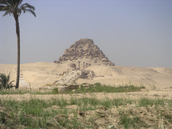
The pyramid of Sahure at Abusir, Egypt.
The pyramid complex of Sahure was built in the 26th to 25th century BCE for the Egyptian pharaoh Sahure. It introduced a period of pyramid building by Sahure’s successors at Abusir, on a location earlier used by Userkaf, founder of the Fifth Dynasty, for his Sun temple.
The pyramid of Sahure was first investigated by the British Egyptologist John Perring, who was the only one who was able to break off and clean the entrance as well as the descending access passage.
The burial chamber was very badly damaged by the stonecutters, and it is not even clear if it was comprised of one or two rooms.
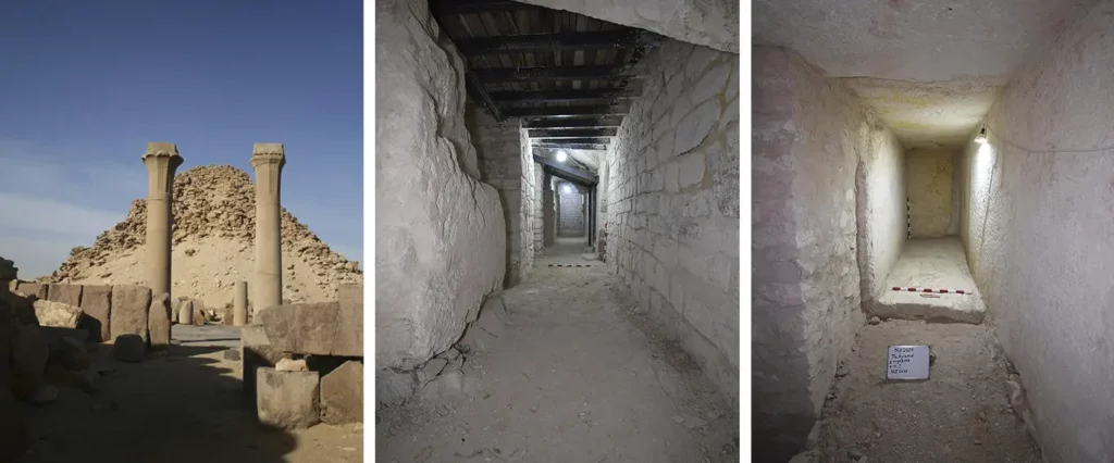
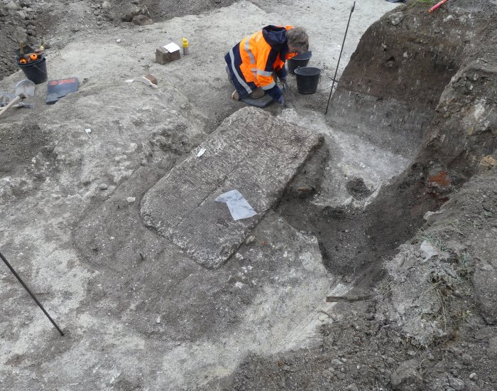
From left to right: Exterior view of the pyramid. A passage secured with steel beams. One of the discovered storage rooms.
Perring found a single fragment of basalt, thinking that it belonged to the king’s sarcophagus.
Interestingly, in the northeastern part of the eastern wall of the burial chamber, Perring discovered a low passageway.
He suggested that this could lead to a magazine area, however, the corridor was full of rubble or waste and he did not attempt to enter it.
Due to the bad state of preservation in the interior compartment of the pyramid, precise reconstruction of the substructure’s plan was impossible.
“The conservation and restoration project inside Sahure’s pyramid, initiated in 2019 and supported by the Antiquities Endowment Fund (AEF) of the American Research Center in Egypt (ARCE), aimed to safeguard the substructure of Sahure’s pyramid,” said Julius-Maximilians-Universität of Würzburg egyptologist Mohamed Ismail Khaled and his colleagues.
“Our efforts focused on cleaning the interior rooms, stabilizing the pyramid from inside, and preventing further collapse.”
“In the process, we succeeded in securing the pyramid’s burial chambers, which had previously been inaccessible.”
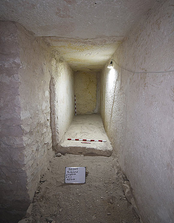
One of the newly-discovered storage rooms in the pyramid of Sahure at Abusir, Egypt.
During the restoration work, they identified the original dimensions and were able to uncover the floor plan of the antechamber, which had deteriorated over time. Consequently, the destroyed walls were replaced with new retaining walls.
“The eastern wall of the antechamber was badly damaged, and only the northeast corner and about 30 cm of the eastern wall were still visible,” the archaeologists said.
“Traces of a low passageway that Perring had already noticed during an excavation in 1836 continued to be excavated.”
“Perring had mentioned that this passage had been full of debris and rubbish and had been impassable due to decay.”
“He suspected that it might have led to storage rooms. However, during further exploration of the pyramid by Ludwig Borchardt in 1907, these assumptions were called into question — other experts joined his opinion.”
“All the more surprising was our discovery of the traces of a passage. Thereby proving that the observations made during Perring’s exploration were correct,” they said.
“The work was continued, and the passage was uncovered. Thus, eight storerooms have been discovered so far.”
“Although the northern and southern parts of these magazines, especially the ceiling and the original floor, are badly damaged, remnants of the original walls and parts of the floor can still be seen.”
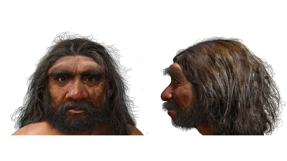
Meet ‘Dragon Man,’ the latest addition to the human family tree
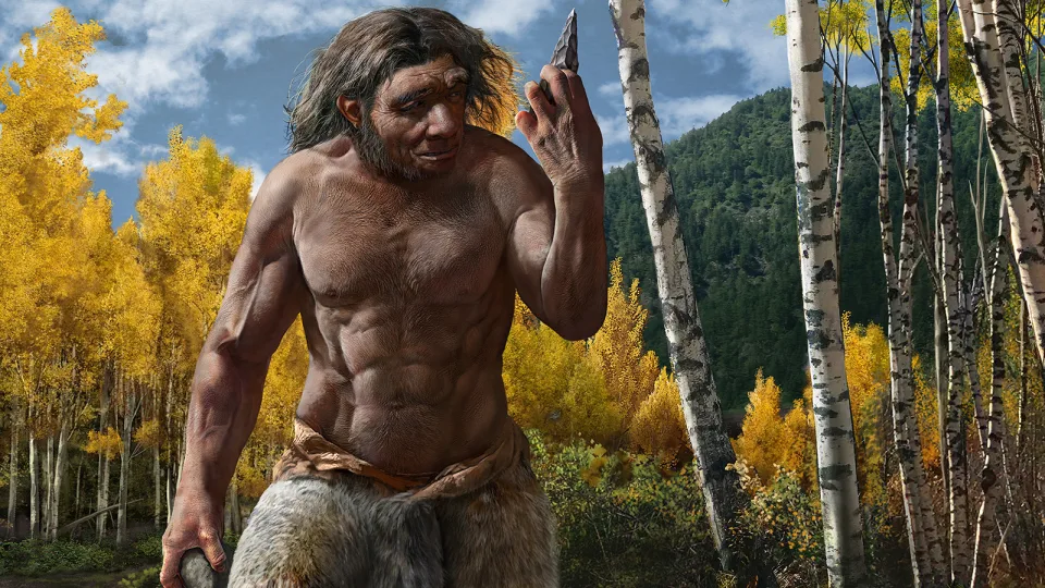
This illustration shows what Homo longi — dragon man — may have looked like.
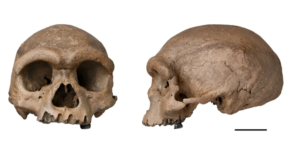
A cranium hidden at the bottom of a well in northeastern China for more than 80 years may belong to a new species of early human that researchers have called “dragon man.”
The exciting discovery is the latest addition to a human family tree that is rapidly growing and shifting, thanks to new fossil finds and analysis of ancient DNA preserved in teeth, bones and cave dirt.
The well-preserved skullcap, found in the Chinese city of Harbin, is between 138,000 and 309,000 years old, according to geochemical analysis, and it combines primitive features, such as a broad nose and low brow and braincase, with those that are more similar to Homo sapiens, including flat and delicate cheekbones.
The ancient hominin – which researchers said was “probably” a 50-year-old man – would have had an “extremely wide” face, deep eyes with large eye sockets, big teeth and a brain similar in size to modern humans.
Three papers detailing the find were published in the journal The Innovation on Friday.
“The Harbin skull is the most important fossil I’ve seen in 50 years. It shows how important East Asia and China is in telling the human story,” said Chris Stringer, research leader in human origins at The Natural History Museum in London and coauthor of the research.
Researchers named the new hominin Homo longi, which is derived from Heilongjiang, or Black Dragon River, the province where the cranium was found. The team plans to see if it’s possible to extract ancient proteins or DNA from the cranium, which included one tooth, and will begin a more detailed study of the skull’s interior, looking at sinuses and both ear and brain shape, using CT scans.
Dragon man’s large size could be an adaptation to the harsh environment in which he likely lived, researchers said.
We are family
It’s easy to think of Homo sapiens as unique, but there was a time when we weren’t the only humans on the block. In the millennia since Homo sapiens first emerged in Africa about 300,000 years ago, we have shared the planet with Neanderthals, the enigmatic Denisovans, the “hobbit” Homo floresiensis, Homo luzonensis and Homo naledi, as well as several other ancient hominins. We had sex with some of them and produced babies. Some of these ancestors are well represented in the fossil record, but most of what we know about Denisovans comes from genetic information in our DNA. The story of human evolution is changing all the time in what is a particularly exciting period for paleoanthropology, Stringer said.
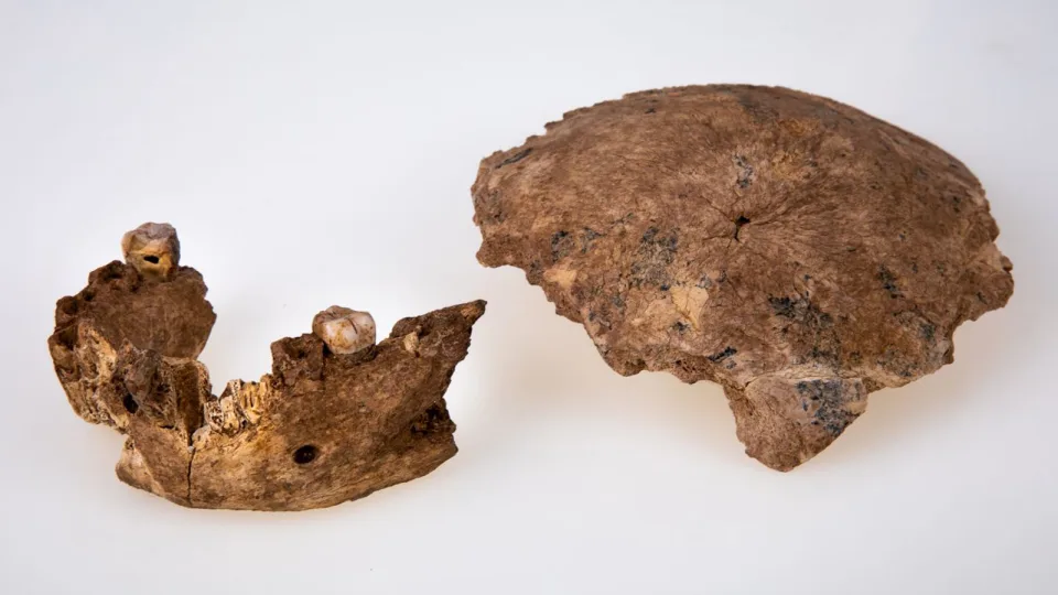
The announcement of dragon man’s discovery comes a day after a different group researchers published a paper in the journal Science on fossils found in Israel, which they said also could represent another new type of early human. The jaw bone and skull fragment suggested a group of people lived in the Middle East 120,000 to 420,000 years ago with anatomical features more primitive than early modern humans and Neanderthals.
While the team of researchers stopped short of calling the group a new hominin species based on the fossil fragments they studied, they said the fossils resembled pre-Neanderthal human populations in Europe and challenged the view that Neanderthals originated there.
“This is a complicated story, but what we are learning is that the interactions between different human species in the past were much more convoluted than we had previously appreciated,” Rolf Quam, a professor of anthropology at Binghamton University and a coauthor of the study on the Israeli fossils, said in a news release
Stringer, who was not involved in the Science research, said the fossils were less complete than the Harbin skull, but it was definitely plausible that different types of humans co-existed in the Levant, which was a geographical crossroads between Africa, Asia and Europe that today includes Lebanon, Syria, Iraq, Israel, Jordan and other countries in the Middle East.
Two fossils found in Israel challenge the idea that Neanderthals originated in Europe.
Concealed treasure
The Harbin cranium was discovered in 1933 by an anonymous Chinese man when a bridge was built over the Songhua River in Harbin, according to one of the studies in The Innovation. At the time, that part of China was under Japanese occupation, and the man who found it took it home and stored it at the bottom of a well for safekeeping.
“Instead of passing the cranium to his Japanese boss, he buried it in an abandoned well, a traditional Chinese method of concealing treasures,” according to the study.
After the war, the man returned to farming during a tumultuous time in Chinese history and never re-excavated his treasure. The skull remained unknown to science for decades, surviving the Japanese invasion, civil war, the Cultural Revolution and, more recently, rampant commercial fossil trading in China, the researchers said.
The third generation of the man’s family only learned about his secret discovery before his death and recovered the fossil from the well in 2018. Qiang Ji, one of the authors of the research, heard about the skull and convinced the family to donate it to the Geoscience Museum of Hebei GEO University.
‘Sister lineage’
The so-called dragon man likely belonged to a lineage that may be our closest relatives, even more closely related to us than Neanderthals, the study found. His large size and where the fossil was found, in one of China’s coldest places, could mean the species had adapted to harsh environments.
Dragon man had a large brain, deep set eyes, thick brow ridges, a wide mouth and oversize teeth.
“We are human beings. It is always a fascinating question about where we were from and how we evolved,” said coauthor Xijun Ni, a research professor at the Chinese Academy of Sciences and the vice director of the Key Laboratory of Vertebrate Evolution and Human Origins.
“We found our long-lost sister lineage.”
The study suggested that other puzzling Chinese fossils that paleoanthropologists have found hard to classify – such as those found in Dali in Yunnan in southwestern China and a jawbone from the Tibetan plateau, thought by some to be Denisovan – could belong to the Homo longi species.
Stringer said also it was definitely plausible that dragon man could be a representative of Denisovans, a little-known and enigmatic human population that hasn’t yet been officially classified as a hominin species according to taxonomic rules.
They are named after a Siberian cave where the only definitive Denisovan bone fragments have been found, but genetic evidence from modern human DNA suggests they once lived throughout Asia.
Denisovans is a general name, Stringer said, and they haven’t officially been recognized as a new species – in part because the five Denisovan fossils that exist are so tiny they don’t fulfill the requirements for a “designated type specimen” that would make it a name-bearing representative.
Denisovans and Homo longi both had large, similar molars, the study noted, but, given the small number of fossils available for comparison, it was impossible to say for sure, said Ni, who hoped that DNA experiments might reveal whether they are the same species.
“We’ve only just begun what will be years of studying this fascinating fossil,” Stringer said.
2,000-year-old Flower Bouquet in ‘Very Good Condition’ Found Under Mexican Pyramid
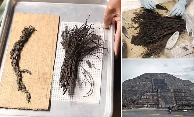
Nearly 2,000 years ago, the ancient people of Teotihuacan wrapped bunches of flowers into beautiful bouquets, laid them beneath a jumble of wood and set the pile ablaze.
Now, archaeologists have found the remains of those surprisingly well-preserved flowers in a tunnel snaking beneath a pyramid of the ancient city, located northeast of what is now Mexico City.
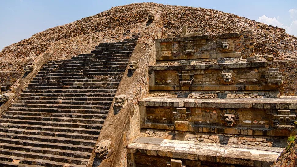
The pyramid itself is immense and would have stood 75 feet (23 meters) tall when it was first built, making it taller than the Sphinx of Giza from ancient Egypt.
The Temple of the Feathered Serpent at Teotihuacan, Mexico
The Teotihuacan pyramid is part of the “Temple of the Feathered Serpent,” which was built in honour of Quetzalcoatl, a serpent god who was worshipped in Mesoamerica.
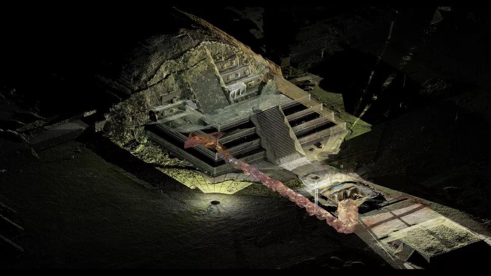
Archaeologists found the bouquets 59 feet (18 m) below ground in the deepest part of the tunnel, said Sergio Gómez-Chávez, an archaeologist with Mexico’s National Institute of Anthropology and History (INAH) who is leading the excavation of the tunnel.
A digital reconstruction of the tunnel running under the pyramid at Teotihuacan.
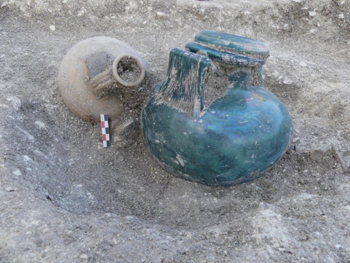
Numerous pieces of pottery, along with a sculpture depicting Tlaloc, a god associated with rainfall and fertility, were found beside the bouquets, he added.
The bouquets were likely part of rituals, possibly associated with fertility, that Indigenous people performed in the tunnel, Gómez-Chávez told Live Science in a translated email.
The team hopes that by determining the identity of the flowers, they can learn more about the rituals.
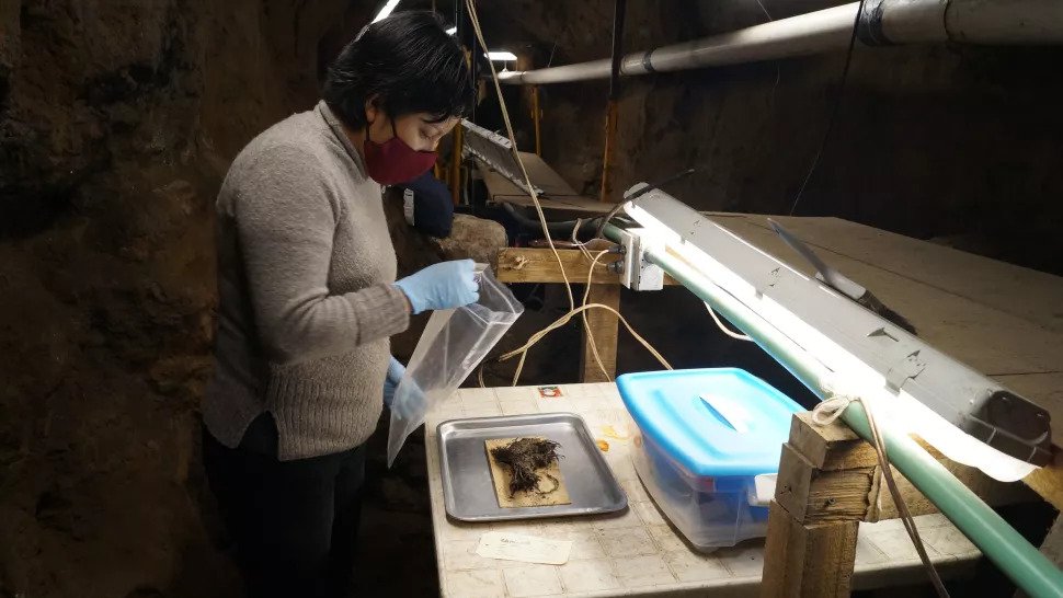
One of the 2,000-year-old bouquets is prepped for research.
The team discovered the bouquets just a few weeks ago. The number of flowers in each bouquet varies, Gómez-Chávez said, noting that one bouquet has 40 flowers tied together while another has 60 flowers.
Archaeologists found evidence of a large bonfire with numerous pieces of burnt wood where the bouquets were laid down, Gómez-Chávez said.
It seems that people placed the bouquets on the ground first and then covered them with a vast amount of wood. The sheer amount of wood seems to have protected the bouquets from the bonfire’s flames.
The tunnel that Gómez-Chávez’s team is excavating was found in 2003 and has yielded thousands of artefacts including pottery, sculptures, cocoa beans, obsidian, animal remains and even a miniature landscape with pools of liquid mercury.
Archaeologists are still trying to understand why ancient people created the tunnel and how they used it.
Teotihuacan contains several pyramids and flourished between roughly 100 B.C. and A.D. 600. It had an urban core that covered 8 square miles (20 square kilometres) and may have had a population of 100,000 people.
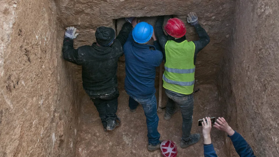
Family Looking For Lost Gold Ring Finds Viking Age Artifacts In Their Garden On The Island Of Jomfruland
While searching for a missing gold ring with a metal detector, a family in Norway found, to their big surprise, something entirely different in their garden on the island of Jomfruland.
Jan Erik Aasvik has a metal detector he almost never uses, but he thought he would try it to search for his mother’s missing gold ring.
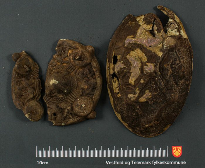
The artifacts were found by the Aasvik family. Suit buckles were not uncommon in the Viking Age. They functioned as decoration and helped keep clothes in place, says archaeologist Vibeke Lia.
After finding a couple of different objects, the detector began beeping distinctly louder than on previous finds. Aasvik suspected this was a sign that something bigger was hidden beneath the soil, but what could it be?
“I took the spade and started digging. I think I was probably no further down than about 20-30 centimeters. I didn’t understand what it was, but it looked old.
I am a member of a group of people who use metal detectors, so I posted a picture there. I am a beginner, but in that group, there are many who have more experience than me”, Aasvik told Kragerø Vestmar.
The Aasvik family was as surprised as happy.
The Aasvik family had discovered a bowl-shaped buckle and a round buckle. Both objects have been there since the 8th century and were used together with clothing in the Viking Age.
Archaeologist Vibeke Lia in Vestfold and Telemark County Municipality, who has seen the buckles, says it is an incredible find, and 1,200-year-old artifacts are in good condition.
“As far as I know, it is the first secure find we have from the Viking Age on Jomfruland,” Lia told the NRK Vestfoldogtelemark, adding this is an exciting archaeological find.
The buckle proves people lived on the island of Jomfruland during the Viking Age.
It is possible there may be a Viking Age grave belonging to a woman at the site, the Cultural Heritage Department in Vestfold and Telemark County said in a press statement.
The find is significant to the history of the region. It was previously assumed people lived on the island in Kragerø during the Viking Age, but scientists have been unable to confirm it until now.
Lia believes there may be more objects in the ground at the site but says digging for more is inappropriate.
“If it is a grave, it is protected. We will rather try to find out more in other ways,” she said.
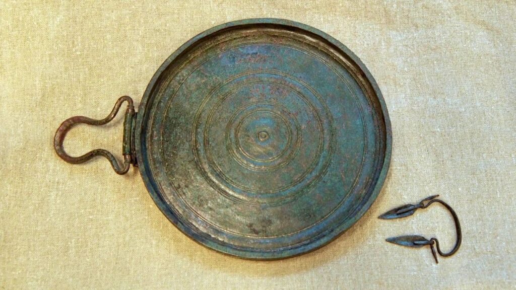
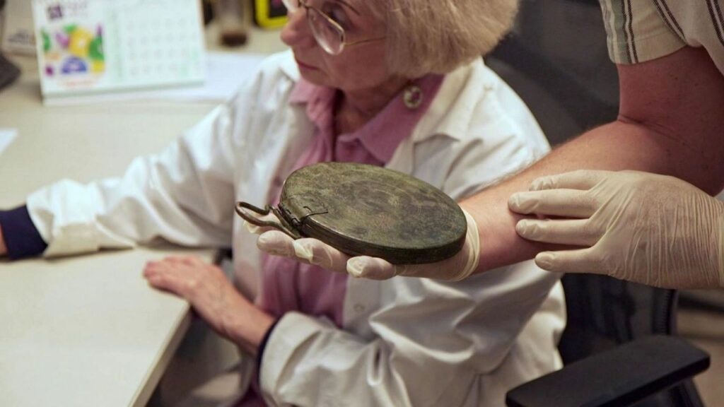
2,300-Year-Old Greek Bronze Mirror Discovered in Israel
Archaeologists in Israel have discovered what they believe to be the remains of an ancient Greek courtesan. The cremated remains of a young woman were found in a burial cave alongside a perfectly preserved bronze box mirror on a rocky slope close to Kibbutz Ramat Rachel, not far from Jerusalem.
The tomb is believed to date back to some time between the late 4th century and early 3rd century BCE, according to a joint study carried out by Tel Aviv University and the Israel Antiquities Authority (IAA).
Guy Stiebel, from the department of archeology and the Ancient Near East at Tel Aviv University, told CNN in a phone interview that the find is “very significant.”
The high-quality mirror was found to be perfectly preserved.
“It’s almost like bringing back to life a woman who passed away 2,300 years ago,” he said of the research, which he compared to a “jigsaw puzzle or riddle.”
He and his team believe this could be the first discovery of the remains of a hetaira, as courtesans were known in Ancient Greece.
“If we are correct with our interpretation, it appears that this burial points to the very unique circumstances of what we call a hetaira, a Greek lady who accompanied one of the Hellenistic government officials, or more likely a high general,” he said.
In the Middle East and eastern Mediterranean, the Hellenistic age refers to the period between the death of Alexander the Great in 323 BCE and the conquest of Egypt by Rome in 30 BCE. Stiebel told CNN that he and his team believe the woman would have been among the first Greeks to arrive in the region.
Liat Oz, the director of the excavation on behalf of the IAA, described the mirror found in the tomb alongside the remains.
“This is only the second mirror of this type that has been discovered to date in Israel, and in total, only 63 mirrors of this type are known around the Hellenistic world,” she said in a news release about the discovery.
Researchers say the mirror is incredibly rare, with just 63 discovered in the Hellenistic world.
“The quality of the production of the mirror is so high that it was preserved in excellent condition, and it looked as if it was made yesterday.”
Folding box mirrors such as this were documented in tombs and temples in the Greco-Hellenistic world, the researchers noted. They were usually decorated with engravings or reliefs of idealized female figures or goddesses.
Stiebel said a woman of high status might have received such a mirror as part of a dowry, but this was unlikely to have been the case in this instance, as married women rarely left their homes in Greece.
Alternatively, he said, she might have been a courtesan, as they often received gifts from men. Likening the hetairai to Japanese geishas, Stiebel explained that the women were regarded as “muses.”
He said: “Women in society were breaking glass ceilings in very strict and male-oriented Greek society, and we do know that they served not only as sexual escorts but were similar to geishas and provided an element of culture. For that they were given gifts and part of the economy of gifts in Ancient Greece had to do with mirrors.”
The fact that the remains were cremated also hinted at the woman’s origins, Stiebel said.
UNESCO designates ancient Jericho ruins as World Heritage Site, sparking Israeli ire
“Cremation is alien to this country and the religion,” he said, explaining that cremation is not only forbidden in Judaism but would not have been practiced by the Persian empire either, which occupied the region at that time.
“The tomb was found in the middle of nowhere, not near any village, farm, or settlement, which suggests that she would have been connected with one of the military campaigns and dated to the time of Alexandra the Great or slightly later.
“We are suggesting that maybe she was with one of the generals.”
Stiebel went on to explain the significance of the four iron nails found with the mirror and remains.
“Nails were used to protect the deceased and also to protect living people from the dead. The bodies were literally nailed down to ensure they would not come back to the world of the living,” he said.
Stiebel told CNN that the team is continuing with further research in order to “zoom in” on the finer details of the mirror.
He said, “We hope to shed more light on the origin of the production of the art and maybe shed more light on the history of the owner of the mirror, the general who bought it, or where she came from.”
The research will be presented for the first time at an Israeli archaeology conference next month.
Archaeologists recently unearthed the remains of a Roman cosmetic and jewelry shop in Turkey.
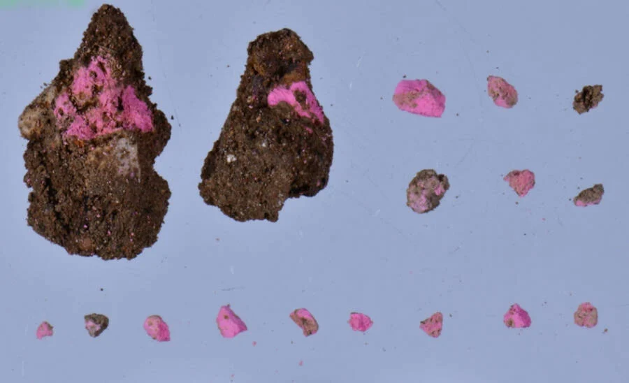
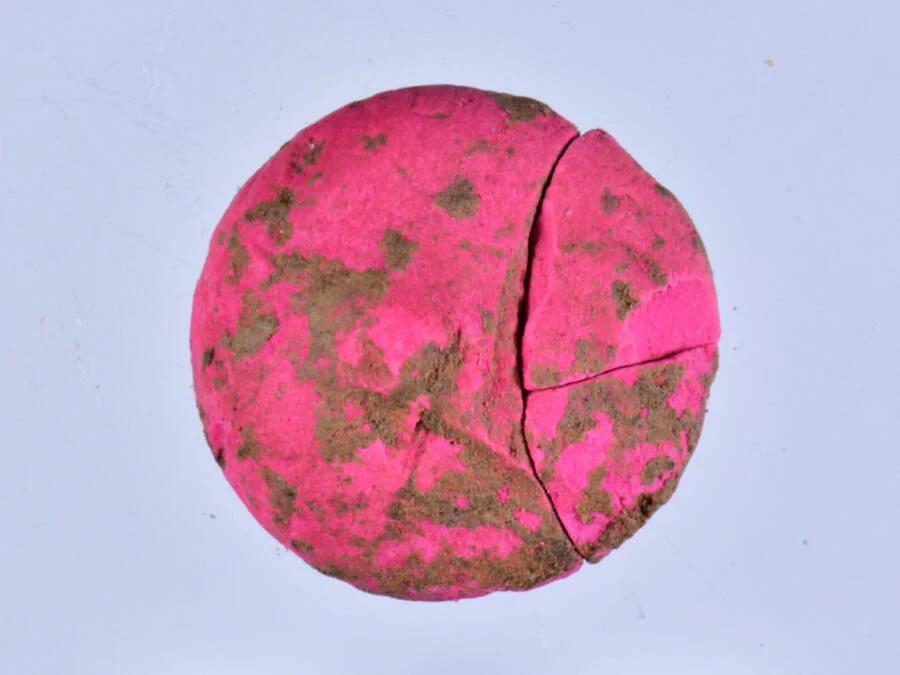
Archaeologists found makeup fragments in brightly-colored hues in the remains of a cosmetics shop in Aizanoi.
Excavations of the ancient city of Aizanoi in modern-day western Turkey have focused on the area near the Temple of Zeus in Anatolia, which was listed on the UNESCO World Heritage Tentative List in 2012, according to the Anadolu Agency.
The team of archaeologists has been focusing on the agora, or marketplace, east of the Temple of Zeus, said excavation head Gokhan Coskun, an archaeologist at Dumlupinar University.
“We determined that the place we completely uncovered was a shop that sold cosmetic products such as perfumes, jewelry, and makeup materials,” Coskun said.
“During the excavation here, we encountered a large number of perfume bottles. In addition to these, there are jewelry items. Among these, there are various beads belonging to products such as hairpins and necklaces used by women.”
Makeup kits found at the site still contained brightly-colored eyeshadow and blush, similar to makeup used today. During the Roman Empire, makeup materials were often placed inside oyster shells.
The makeup found at the Aizanoi agora was mostly in shades of bright pink and red.
“One of the most surprising findings was that we came across were makeup pigments similar to blush and eyeshadow used today,” Coskun said.
“Of course, they are not in a very well-preserved state. Sometimes they are found in 1- or 2-millimeter pieces. We also found well-preserved pieces during the excavation.”
Coskun said they found “a large number” of oyster shells in the shop area. They uncovered makeup in 10 different colors, but the vast majority were in bright hues of red and pink.
The excavations at the Aizanoi marketplace have been yielding stunning results over recent years, with another discovery in 2021 producing a bone workshop with tools and an oil lamp shop with intact lamps.
“Findings from both shops show us that local products were manufactured in Aizanoi,” Coskun said at the time. “It is an important finding for us that important production activities were carried out in Aizanoi during the Roman era.”
Excavations in Aizanoi more broadly have been ongoing since 1926, with excavations of the agora site dating back to 1970, according to Arkeonews.
The city of Aizanoi has been a significant focus of excavation in recent years. Archaeologists have found evidence of several different settlements dating back to 3000 B.C.E., and in 133 B.C.E., it was captured by the Roman Empire.
Archaeologists believe that Aizanoi was an important political and economic center during the Roman Empire. Many remains of ancient buildings and statues have been excavated, including the temple, one of the most well-preserved Zeus temples in the world.
The Temple of Zeus in Aizanoi is one of the most well-preserved Zeus temples in the world.
There was also a combined theater and stadium complex, the only known one of its kind in the ancient world, according to the UNESCO World Heritage Convention. Aizanoi was also home to one of the first stock markets in the world.
Aizanoi likely fell into decline around the seventh century C.E. European travelers discovered the remains of the city in 1824.
Excavations between 1970 and 2011 revealed the remains of several other notable buildings and structures, including public baths, a gymnasium, bridges, a necropolis, and a sacred cave believed to be an ancient cultist site.
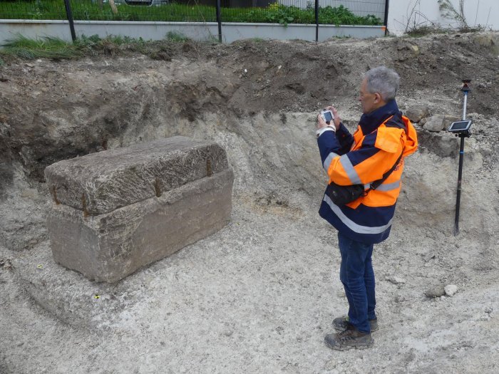
Intact 1,800-Year-Old Roman Sarcophagus With Unexpected Treasures Found In France
It does not happen often that archaeologists find an ancient, unlooted Roman sarcophagus. When it happens, like it just did in France, it is an excellent opportunity to learn more about the past.
“It’s quite exceptional, it’s the first time that we have found a tomb intact and which has not been looted. It was sealed by eight iron staples, and we were the first to explore it,” Agnès Balmelle, deputy scientific and technical director at Inrap Grand Est, told local news Le Parisien.
Archaeologists have discovered an intact Roman sarcophagus in Reims.
The 1,800-year-old sarcophagus was unearthed by a team of archaeologists from INRAP (France’s National Institute for Preventive Archaeology) excavating in the vast ancient necropolis at Rue Soussillon.
The ancient Durocortorum (Reims) was the capital of the province of Gaul Belgium, and one of the largest cities in the Roman Empire.
Scientists have excavated 1,200 m² on Rue Soussillon, which represents only a portion of a vast ancient necropolis.
The high density of tombs is particularly interesting in this part of the city since it has long been considered a swampy area unsuitable for any settlement.
Photogrammetry survey of the sarcophagus.
During the recent excavation, scientists discovered a lime sarcophagus limestone that measures 3.3 feet high, 5.4 feet long, and 2.6 feet wide, with a 1,700-pound lid held in place by iron pegs sealed with lead.
The archaeologists first did X-rays on the sarcophagus then used an endoscopic camera.
Glass urn and jug found at the archaeological site.
Inside the sarcophagus were funerary goods placed next to the skeleton of a woman.
“The skeleton occupied the entire space of the [5-foot] tank, the individual must have been around 40 years old and had a special status. Four oil lamps were found near her legs and shoulders, as well as a small mirror, an amber ring, and a comb,” Balmelle told the press.
Small jug taken during the dismantling of a burial.
Inside the sarcophagus were also two glass containers possibly containing perfumed oils.
The unearthed items indicate that the burial occurred in the 2nd century A.D. Samples of the sediment on the bones and on the bottom of the tank will make it possible to determine if there are plant remains or products linked to the treatment of bodies.
Furthermore, the Inrap team in Reims is building a genetic database on ancient Reims funerary complexes as part of a research project.
DNA taken from a tooth from the skeleton will be compared to 80 samples to determine whether this woman belongs to a local or more distant elite.
9,500-Year-Old Baskets And 6,200-Year-Old Sandals Found In Spanish Cave
Scientists have discovered and analyzed the first direct evidence of basketry among hunter-gatherer societies and early farmers in southern Europe (9,500 and 6,200 years ago), in the Cueva de los Murciélagos of Albuñol (Granada, Spain).
This site is one of the most emblematic archaeological sites of prehistoric times in the Iberian Peninsula due to the unique preservation of organic materials found there.
The work analyzes 76 objects made of organic materials (wood, reed and esparto) discovered during 19th century mining activities in the Granada cave.
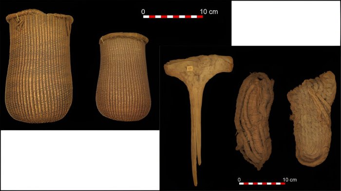
The oldest Mesolithic baskets in southern Europe, 9,500 years old (left), and wooden mace and esparto sandals, dating back to the Neolithic 6,200 years ago (right).
The researchers studied the raw materials and technology and carried out carbon-14 dating, which revealed that the set dates to the early and middle Holocene period, between 9,500 and 6,200 years ago.
This is the first direct evidence of basketry made by Mesolithic hunter-gatherer societies in southern Europe and a unique set of other organic tools associated with early Neolithic farming communities, such as sandals and a wooden mace.
As researcher of the Prehistory Department of the University of Alcalá Francisco Martínez Sevilla explains, “the new dating of the esparto baskets from the Cueva de los Murciélagos of Albuñol opens a window of opportunity to understanding the last hunter-gatherer societies of the early Holocene.”
“The quality and technological complexity of the basketry makes us question the simplistic assumptions we have about human communities prior to the arrival of agriculture in southern Europe. This work and the project that is being developed places the Cueva de los Murciélagos as a unique site in Europe to study the organic materials of prehistoric populations.”
Cueva de los Murciélagos is located on the coast of Granada, to the south of the Sierra Nevada and 2 kilometers from the town of Albuñol. The cave opens on the right side of the Barranco de las Angosturas, at an altitude of 450 meters above sea level and about 7 kilometers from the current coastline. It is one of the most emblematic prehistoric archaeological sites of the Iberian Peninsula due to the rare preservation of organic materials, which until this study had only been attributed to the Neolithic.
The objects made of perishable materials were discovered by the mining activities of the 19th century and were documented and recovered by Manuel de Góngora y Martínez, later becoming part of the first collections of the National Archaeological Museum of Madrid.
As detailed by María Herrero Otal, co-author of the work and researcher at the Universitat Autònoma de Barcelona, “The esparto grass objects from Cueva de los Murciélagos are the oldest and best-preserved set of plant fiber materials in southern Europe so far known.”
“The technological diversity and the treatment of the raw material documented demonstrates the ability of prehistoric communities to master this type of craftsmanship, at least since 9,500 years ago, in the Mesolithic period.
Only one type of technique related to hunter-gatherers has been identified, while the typological, technological and treatment range of esparto grass was extended during the Neolithic from 7,200 to 6,200 years before the present.”
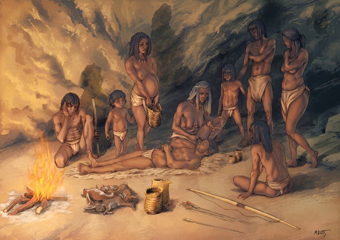
Artistic recreation of the use of Mesolithic baskets by a group of hunter-gatherers in the Cueva de los Murciélagos de Albuñol. Credit: Drawing by Moisés Belilty Molinos, with scientific supervision of Francisco Martínez-Sevilla and Maria Herrero-Otal
The work is part of the project “De los museos al territorio: actualizando el estudio de la Cueva de los Murciélagos de Albuñol (Granada)” (MUTERMUR). The objective of this project is the holistic study of the site and its material record, applying the latest archaeometric techniques and generating quality scientific data.
The project also included the collaboration of the National Archaeological Museum, the Archaeological and Ethnological Museum of Granada, the City Council of Albuñol and the owners of the cave.
“The results of this work and the finding of the oldest basketry in southern Europe give more meaning, if possible, to the phrase written by Manuel de Góngora in his work Prehistoric Antiquities of Andalusia (1868): ‘the now forever famous Cueva de los Murciélagos’,” the authors say.
The study was conducted by a team of scientists led by researchers from the Universidad de Alcalá (UAH) and the Universitat Autònoma de Barcelona (UAB), and published in the journal Science Advances.