Category Archives: ARMENIA

Ruins of a 3000-year-old Armenian castle found in Lake Van – Turkey

Ruins of a 3000-year-old Armenian castle found in Lake Van – Turkey

Ruins of a 3000-year-old Armenian castle found in Lake Van – Turkey
Underwater ruins of Armenian castle in lake Van ( Anadolu Ajansı )

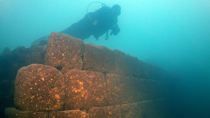
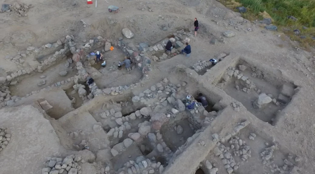
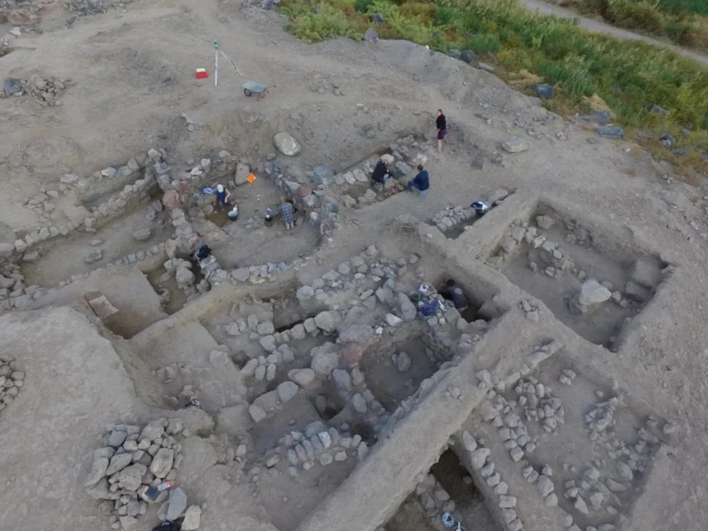
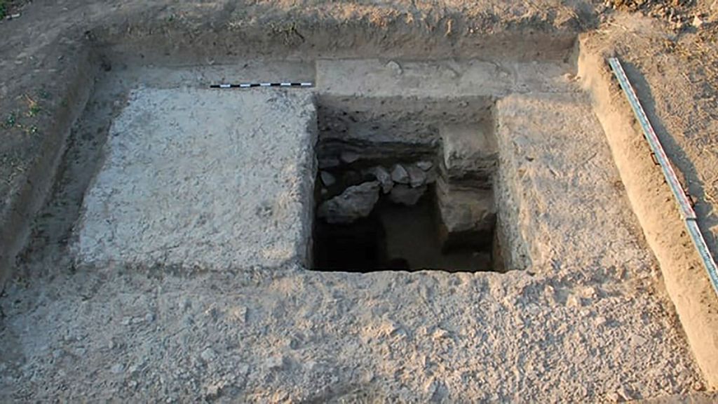
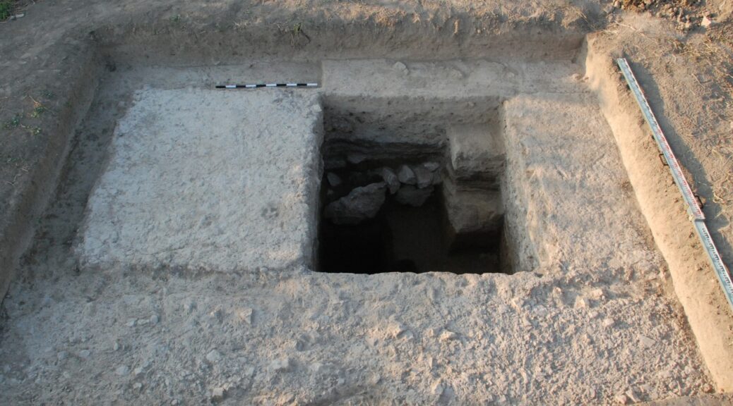
A team of Turkish archaeologists has discovered the remains of what is believed to be a 3,000-year-old castle from the Armenian kingdom of Urartu (Ararat) submerged underwater in Lake Van.

The underwater excavations were led by Van Yüzüncü Yıl University and the governorship of Turkey’s eastern Bitlis Province. The castle is said to belong to the Iron Age Armenian civilization also known as the Kingdom of Van, Urartu, Ararat, and Armenia.

The lake itself is believed to have been formed by a crater caused by a volcanic eruption of Mount Nemrut near the province of Van. The current water level of the reservoir is about 150 meters higher than it was during the Iron Age.

“Civilizations living around the lake set up large villages and settlements while the water level of the lake was low, but they had to leave the area after it increased again,”

said Tahsin Ceylan, one of the researchers of the newspaper.

The researchers are expecting to conduct further excavations to reveal the full scale of this discovery. The discovery is expected to attract tourism.

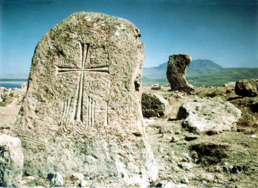
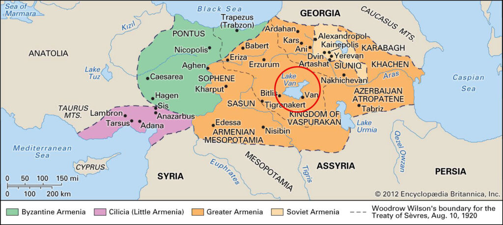
Although now within the borders of the Republic of Turkey, the Lake, and town of Van is the very heartland of Armenian civilization since times immemorial. In fact, so much so, that it is considered the very place where Armenian ethnic identity was first born. According to the records of the 5th-century Armenian historian Movses of Khorene, Hayk (the legendary founder of the Armenian nation) settled near Lake Van in 2492 BC where he first founded the village of Haykashen and build there the mighty fortress of Haykaberd.

At the very shores of Lake, Van Hayk assembled his army and told them that they must defeat the Babylonian tyrant king Bel who had marched against him and his people, or die trying to do so, rather than become his slaves. At Dyutsaznamart (meaning: “Battle of Giants”) near Lake Van, Hayk finally defeated Bel. Hereafter Hayk named the region where the battle took place after his own name and the site of the battle Hayots Dzor (meaning: “Valley of the Armenians”). Thus the Armenian nation and its first free kingdom were born on the very shores of Lake Van after which the Armenians call themselves ‘Hay’ and their country – ‘Hayk’ or ‘Hayastan’, in honor of the legendary founder Hayk.

The ancient Hittite inscriptions deciphered in the 1920s by the Swiss scholar Emil Forrer testify to the existence of a mountain country called ‘Hayasa’ and its vessel lying around Lake Van. The Annals of Mursili (14th century BC) describes the campaigns of Mursili against Hayasa:

And when I arrived in Tiggaramma, the chief cup-bearer Nuvanza and all the noblemen came to meet me at Tiggaramma. I should have marched to Hayasa still, but the chiefs said to me, ‘The season is now far advanced, Sire, Lord! Do not go to Hayasa.’ And I did not go to Hayasa.

Map of historic Armenian with Lake Van at its center. (from Encyclopædia Britannica Online)

It was exactly the works of Movses of Khorene that led to the initial discovery of the Armenian kingdom of Van (Urartu). The existence of this kingdom was unknown to science until the year 1823 when a French scholar, J. Saint-Martin, chanced upon a passage in the ‘History of Armenia’ by Movses of Khorene who had recorded the kingdom in great detail. Inspired by these writings Jean Saint-Martin sent a team to the described location and discovered a kingdom completely unknown to Western academia at the time.

Khorenatsi had described the ancient settlements in Van and attributed them to one of the descendants of Hayk; Ara the Beautiful son of Aram. His description exactly matched, the later discovered, Assyrian clay tablet attributing the foundation of the kingdom to the first king of Urartu; King Aram (c. 860 – 843 BC).

“Urartian history is part of Armenian history, in the same sense that the history of the ancient Britons is part of English history, and that of the Gauls is part of French history. Armenians can legitimately claim, through Urartu, an historical continuity of some 4000 years; their history is among those of the most ancient peoples in the world.”

– Mack Chahin, The Kingdom of Armenia, A History, 1987, revised in 2001

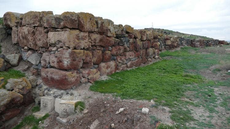
The lake was the center of the Armenian kingdom of Ararat from about 1000 BC, afterward of the Satrapy of Armenia, Kingdom of Greater Armenia, and the Armenian Kingdom of Vaspurakan. Along with Lake Sevan in today’s Armenia and Lake Urmia in today’s Iran, Lake Van was one of the three great lakes of the Armenian Kingdom, referred to as the Seas of Armenia. Its name “Van” is one of the ancient Armenian words for “town” which is still reflected in many Armenian toponyms such as Nakhichevan (meaning: “place/town of descend”), Stepananvan (meaning: “town of Stepan”), Vanadzor (meaning: “valley of Van” ), Sevan, and even the capitol city of Armenia; Yerevan.

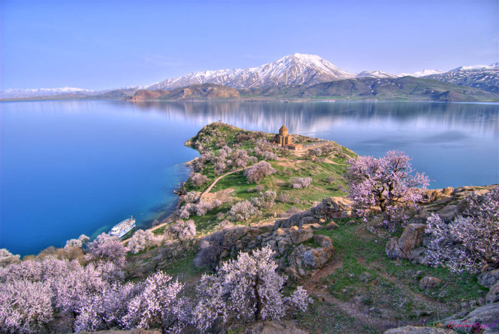
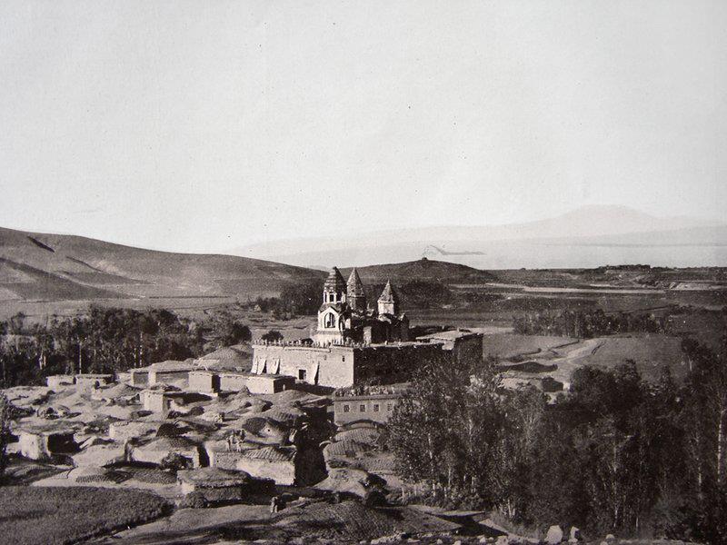
Lake Van and its adjacent town also named Van is today part of Turkey, however, its historic Armenian traces are still visible. At the very center of this lake, there is an island called Akhtamar that still holds a thousand-year-old Armenian church; the Cathedral of the Holy Cross.

Armenians lived in Van up until the early 20th century when Armenians were prosecuted by the Ottoman Turks during the Armenian Genocide. One of the last stands of the Armenian people known as the Resistance of Van, where over 55,000 Armenian civilians were massacred by Ottoman militias and bandits, was extensively discussed in newspapers of that time around the world.

The resistance occupies a significant place in Armenian national identity because it symbolizes the Armenians’ will to resist annihilation at the very heartland of the Armenian people.

General view of Akdamar (Akhtamar) Island and the Armenian cathedral of the Holy cross (915 AD).
Medieval Armenian gravestones, Lake Van.
An early 20th century picture of the 10th century Armenian monastery of Narekavank, which once stood near the southeastern shore of the lake.

Archaeologists uncovered a ‘golden tomb’ during excavations in Armenia

Archaeologists uncovered a ‘golden tomb’ during excavations in Armenia

Archaeologists uncovered a ‘golden tomb’ during excavations in Armenia

A team of archaeologists made up of Polish and Armenian scientists has discovered a “golden tomb” containing two skeletons in Metsamor, Armenia.

The team discovered the remains of three gold necklaces while excavating the grave of two people, most likely a couple (a man and a woman). The tomb dates back to Ramesses II’s rule over Egypt.

Metsamor is one of the most studied archaeological monuments of V-I century BC in the Armenian Highland, and throughout the Ancient Near East. It includes the Bronze-Iron Age settlement (citadel, city districts, and celestial observation platform) as well as the cemetery.

The land area exceeds 200 hectares. The site is located in the Ararat plain, about 35 kilometers west of Yerevan, in the Taronik administrative district.

The ancient site of Metsamor is the place where the oldest known gold jewelry in the territory of Armenia was found.

Discovery was a cist grave, meaning that the two skeletons were found in chambers dug in the ground and lined with large stones. Researchers also found the remains of a wooden burial bed.

Metsamor. View of the citadel.

“Their death is a mystery to us, we do not know the cause, but everything indicates that they died at the same time, because there are no traces of tomb reopening,” said the head of the research project, Professor Krzysztof Jakubiak from the Faculty of Archaeology of the University of Warsaw.

The bones, according to archaeologists, were well preserved. Both skeletons had slightly crouched legs. According to preliminary estimates, the couple died between the ages of 30 and 40.

Professor Krzysztof Jakubiak believes that this is a unique find because the very richly equipped grave has not been robbed.

Archaeologists discovered over a hundred beads and gold pendants inside the tomb. Some of them look like Celtic crosses. There were also a large number of carnelian pendants.

“All these elements probably made up three necklaces,” said Professor Jakubiak.

The ancient site of Metsamor is the place where the oldest known gold jewelry in the territory of Armenia was found.

A dozen or so complete ceramic vessels and a unique faience flask were also found in the grave. The flask had not been made in the area. It was brought from the Syrian-Mesopotamian borderland, according to the researchers.

Archaeologists do not know who lived in Metsamor at that time (in the second half of the 2nd millennium BCE). The people who inhabited the large, fortified settlement there were not literate, so they left no texts. This makes identifying them difficult for scientists.

Jakubiak said: “But it was a very large settlement. Even fortifications made of huge stone blocks have survived to our times, encircling the so-called citadel on the hill. At the end of the 2nd millennium BCE, there was no other settlement in the region that could be compared in terms of importance and size.”

Archaeologists discover ancient fortune-telling shrines in Armenia

Archaeologists discover ancient fortune-telling shrines in Armenia

Archaeologists say three 3,300-year-old shrines set up by an unknown culture in Armenia apparently were used for occult divination.

This shrine was excavated at the entrance of a fortress’ west terrace in Gegharot in Armenia. The stone monument was probably the focal point for rituals practised there 3,300 years ago, archaeologists say.

Three shrines, dating back about 3,300 years, have been discovered within a hilltop fortress at Gegharot in Armenia. Local rulers at the time probably used the shrines for divination, a practice aimed at predicting the future, the archaeologists involved in the discovery say.

Each of the three shrines consists of a single room holding a clay basin filled with ash and ceramic vessels. Wide varieties of artefacts were discovered, including clay idols with horns, stamp seals, censers used to burn substances and a vast amount of animal bones with markings on them.

During divination practices, the rulers and diviners may have burnt intoxicating substances and drank wine, allowing them to experience altered states of mind, the archaeologists say.

“The logic of divination presumes that variable pathways articulate the past, present and future, opening the possibility that the link between a current situation and an eventual outcome might be altered,” Adam Smith and Jeffrey Leon write in an article published recently in the American Journal of Archaeology.

Smith is a professor at Cornell University, and Leon is a graduate student there.

Excavations at the shrines are part of the American-Armenian Project for the Archaeology and Geography of Ancient Transcaucasian Societies, also known as Project ArAGATS.

The shrines were unearthed over a period stretching from 2003 to 2011.

Smith told LiveScience that the region’s rulers probably used Gegharot as an occult centre. At the time, writing had not yet spread to this part of Armenia, so the names of the polity and its rulers are unknown.

Smith and Leon found evidence for three forms of divination at Gegharot. One form was osteomancy, trying to predict the future through rituals that involved rolling the marked-up knucklebones of cows, sheep and goats like dice.

Lithomancy, trying to predict the future through the use of coloured pebbles, also appears to have been practised at Gegharot.

And at one shrine, the archaeologists found an installation used to grind flour. Smith and Leon think that this flour could have been used to predict the future in a practice called aleuromancy. 

The shrines were in use for a century or so until the surrounding fortress, along with all the other fortresses in the area, were destroyed.

The site was largely abandoned after this, Smith said. Although the rulers who controlled Gegharot put great effort into trying to predict and change the future, it was to no avail.

Water Surprise: Ancient Aqueduct Unearthed At Edge Of Roman Empire

Water Surprise: Ancient Aqueduct Unearthed At Edge Of Roman Empire

Archaeologists have unearthed what they say is the easternmost aqueduct built by the Roman Empire. Researchers from the National Academy of Sciences of the Republic of Armenia and from the University of Münster in Germany said they discovered the remains of the arched aqueduct in the ancient Armenian city of Artaxata.

Excavation of the aqueduct began in 2019, and the University of Münster released a statement this month detailing the findings of a study published in the journal Archäologischer Anzeiger.

Professor Achim Lichtenberger of the University of Münster said Romans constructed the aqueduct between A.D. 114 and 117.

Samples taken from the soil near the construction site were dated to between A.D. 60 and 460. This led the researchers to conclude that the aqueduct was most likely built under the reign of Emperor Trajan, during which the Roman Empire reached its territorial peak.

Trajan was considered a successful military ruler who oversaw the second-greatest military expansion in the history of the Roman Empire, after Augustus.

Torben Schreiber, the paper’s co-author, said that the construction was never actually completed, as Trajan died in A.D. 117 and the next emperor, Hadrian, gave up the province of Armenia, leaving the aqueduct half-completed.

The excavation area in Artaxata, Armenia, where researchers found what they say is the easternmost aqueduct built by the Roman Empire, with Mount Ararat visible behind it just over the modern border in Turkey.

Hadrian ruled from A.D. 117 to 138 and abandoned many of his predecessor’s expansionist military campaigns including the one in Armenia, resulting in disapproval from much of the empire’s elite.

He is known in Britain for having built Hadrian’s Wall, which served as a marker for the northernmost point of Roman-controlled Britannia.

Aqueducts were a cornerstone of Roman cities and towns, used to bring water into the populated territories from the surrounding areas.

German and Armenian experts used a variety of methods drawn from the fields of geophysics, archaeology, and geochemistry in the excavation work.

Geomagnetic examinations were carried out to locate areas of interest in Artaxata, then samples were taken using drills to pinpoint the aqueduct’s location. Mkrtich Zardaryan, a co-author of the study, said satellite and infrared imagery was then used to chart the path of the aqueduct’s pillars.

“We reconstructed the planned course of the aqueduct by means of a computer-assisted path analysis between the possible sources of the water and its destination,” he said.

The researchers concluded from the findings that the incomplete aqueduct in Armenia is evidence of the empire’s failure to expand into the region.

Traces of Unfinished Roman Aqueduct Uncovered in Armenia

Traces of Unfinished Roman Aqueduct Uncovered in Armenia

Archaeologists from the University of Münster and the National Academy of Sciences of the Republic of Armenia have discovered remains of a Roman arched aqueduct during excavation work on the Hellenistic royal city of Artashat-Artaxata in ancient Armenia.

It is the easternmost arched aqueduct in the Roman Empire. Excavation work took place back in 2019, and an evaluation of the find has now been published in the “Archäologischer Anzeiger” journal.

“The monumental foundations are evidence of an unfinished aqueduct bridge built by the Roman army between 114 and 117 CE,” explains author Prof. Achim Lichtenberger from the Institute of Classical Archaeology and Christian Archaeology at the University of Münster.

“At that time, Artaxata was destined to become the capital of a Roman province in Armenia.”

It was during this time that the Roman Empire reached its greatest extent – if only for a short while – because it was under Trajan, who was Emperor of Rome from 98 to 117 CE – that the Romans attempted to incorporate the province of Armenia into the Roman Empire.

“The planned, and partially completed, construction of the aqueduct in Artaxata shows just how much effort was made, in a very short space of time, to integrate the infrastructure of the capital of the province into the Empire,” says co-author Torben Schreiber from the Institute of Classical Archaeology and Christian Archaeology at the University of Münster.

“The aqueduct remained unfinished because after Trajan’s death, in 117 CE, his successor Hadrian relinquished the province of Armenia before the aqueduct was completed.”

The archaeologists, therefore, see their find as furnishing evidence for the failure of Roman imperialism in Armenia.

Methods

In their excavation campaign, the team used a multidisciplinary combination of methods from the fields of archaeology, geophysics, geochemistry and archaeoinformatics.

In the background of the excavation area is the hillock in Artaxata on which is located the Khor Virap monastery, with Mount Ararat behind it.

The area of the Hellenistic metropolis of Artaxata in the Ararat Plain was first examined geomagnetically. At this stage of their work, the experts surveyed and charted any anomalies.

The geomagnetic image showed a conspicuous dotted line, which they analysed with so-called sondages. The results were documented by the archaeologists three-dimensionally.

Additional drillings provided evidence of further unfinished or destroyed pillars of the aqueduct.

“We used satellite pictures and infrared images from a drone to visualise the course of the aqueduct’s pillars,” says co-author Dr Mkrtich Zardaryan from the Institute of Archaeology and Ethnography at the National Academy of Sciences of the Republic of Armenia.

“We reconstructed the planned course of the aqueduct by means of a computer-assisted path analysis between the possible sources of the water and its destination.”

READ ALSO: 7,500 -YEARS-OLD “ARMENIAN STONEHENGE” DISCOVERED AT CARAHUNGE (THE ARMENIAN STONEHENGE)

A scientific analysis of the lime mortar used showed that it was a typical Roman recipe.

An analysis of soil samples dated the construction of the aqueduct to between 60 and 460 CE, and in the opinion of the researchers, this makes the reign of Emperor Trajan the most likely dating for it.

Project: “Artaxata in Armenia – Fieldwork in a Hellenistic Metropolis in the Ararat Plain”

Since 2018 a team of German and Armenian scientists – headed by Achim Lichtenberger (Münster University), Mkrtich Zardaryan (Armenian Academy of Sciences) and Torben Schreiber (Münster University) – have been carrying out research into the Hellenistic metropolis of Artaxata in the Ararat Plain in Armenia. Their aim is to examine both a newly established Hellenistic royal city and the many-faceted cultural imprint between Central Asia, Iran and the Mediterranean region.

Funding

The excavation project is being funded by the National Academy of Sciences of the Republic of Armenia and by the German Research Foundation (DFG).

World’s oldest leather shoe which is 1,000 years older than the Great Pyramid.

World’s oldest leather shoe which is 1,000 years older than the Great Pyramid.

In a cave in Armenia, a fully preserved shoe has been discovered, 1,000 years older than the Great Pyramid of Giza in Egypt and 400 years older than Stonehenge in the UK.

A team of global archaeologists found the 5,500-year-old shoe, the world’s oldest leather shoe, and their findings will be published in the online science journal PLoS ONE.

The cow-hide shoe dates back to ~ 3,500 BC (the Chalcolithic period) and is in perfect condition. It was made of a single piece of leather and was shaped to fit the wearer’s foot.

It contained grass, although the archaeologists were uncertain as to whether this was to keep the foot warm or to maintain the shape of the shoe, a precursor to the modern shoe-tree perhaps? “It is not known whether the shoe belonged to a man or woman,” said lead author of the research, Dr Ron Pinhasi, University College Cork, Cork, Ireland “as while small (European size 37; US size 7 women), the shoe could well have fitted a man from that era.”

The cave is situated in the Vayotz Dzor province of Armenia, on the Armenian, Iranian, Nakhichevanian and Turkish borders, and was known to regional archaeologists due to its visibility from the highway below.

The stable, cool and dry conditions in the cave resulted in exceptional preservation of the various objects that were found, which included large containers, many of which held well-preserved wheat and barley, apricots and other edible plants.

The preservation was also helped by the fact that the floor of the cave was covered by a thick layer of sheep dung which acted as a solid seal over the objects, preserving them beautifully over the millennia!

“We thought initially that the shoe and other objects were about 600-700 years old because they were in such good condition,” said Dr Pinhasi.

“It was only when the material was dated by the two radiocarbon laboratories in Oxford, UK, and in California, the US that we realised that the shoe was older by a few hundred years than the shoes worn by Ötzi, the Iceman.”

Three samples were taken in order to determine the absolute age of the shoe and all three tests produced the same results.

The archaeologists cut two small strips of leather off the shoe and sent one strip to the Oxford Radiocarbon Accelerator Unit at the University of Oxford and another to the University of California -Irvine Accelerator Mass Spectrometry Facility. A piece of grass from the shoe was also sent to Oxford to be dated and both shoe and grass were shown to be the same age.

The shoe was discovered by an Armenian PhD student, Ms Diana Zardaryan, of the Institute of Archaeology, Armenia, in a pit that also included a broken pot and wild goat horns.

“I was amazed to find that even the shoe-laces were preserved,” she recalled. “We couldn’t believe the discovery,” said Dr Gregory Areshian, Cotsen Institute of Archaeology at UCLA, US, co-director who was at the site with Mr Boris Gasparyan, co-director, Institute of Archaeology, Armenia when the shoe was found. “The crusts had sealed the artefacts and archaeological deposits and artefacts remained fresh dried, just like they were put in a can,” he said.

The oldest known footwear in the world, to the present time, are sandals made of plant material, that were found in a cave in the Arnold Research Cave in Missouri in the US. Other contemporaneous sandals were found in the Cave of the Warrior, Judean Desert, Israel, but these were not directly dated so that their age is based on various other associated artefacts found in the cave.

Interestingly, the shoe is very similar to the ‘pampooties’ worn on the Aran Islands (in the West of Ireland) up to the 1950s.

“In fact, enormous similarities exist between the manufacturing technique and style of this shoe and those found across Europe at later periods, suggesting that this type of shoe was worn for thousands of years across a large and environmentally diverse region,” said Dr Pinhasi.

“We do not know yet what the shoe or other objects were doing in the cave or what the purpose of the cave was,” said Dr Pinhasi. “We know that there are children’s graves at the back of the cave but so little is known about this period that we cannot say with any certainty why all these different objects were found together.” The team will continue to excavate the many chambers of the cave.

The team involved in the dig included; lead author and co-director, Dr Ron Pinhasi, Archaeology Department, University College Cork, Cork, Ireland; Mr Boris Gasparian, co-director and Ms Diana Zardaryan of the Institute of Archaeology and Ethnography, National Academy of Sciences, Republic of Armenia; Dr Gregory Areshian, co-director, Research Associate at the Cotsen Institute of Archaeology, University of California, US; Professor Alexia Smith, Department of Anthropology of the University of Connecticut, US, Dr Guy Bar-Oz, Zinman Institute of Archaeology, University of Haifa, Israel and Dr Thomas Higham, Oxford Radiocarbon Accelerator Unit, University of Oxford, UK.

A researcher holds the ancient shoe at the Armenian Institute of Archaeology and Ethnography.

The research received funding from the National Geographic Society, the Chitjian Foundation (Los Angeles), US, Mr Joe Gfoeller of the Gfoeller Foundation of US, the Steinmetz Family Foundation, US, the Boochever Foundation, US, and the Cotsen Institute of Archaeology, UCLA, US.

A Mysterious 3,000-Year-Old Castle Has Been Found Under a Lake in Turkey

A Mysterious 3,000-Year-Old Castle Has Been Found Under a Lake in Turkey

A story describing the ruins of an ancient castle buried underneath the picturesque waters of Lake Van, Turkey, has been proclaimed entirely real.

The preserved ruins of a castle dating back more than 3,000 years to the Iron Age under the civilisation of Urartu have been found by archaeologists from Van Yüzüncü Yıl University.

Tahsin Ceylan, head of the dive team, told the Turkish Daily Saba that “There was a report that there was something under the water but most archaeologists and museum officials told us that we’re not going to find it.” Instead, Ceylan and his team ended up uncovering a massive fortress spanning a kilometre over the lakebed.

A Mysterious 3,000-Year-Old Castle Has Been Found Under a Lake in Turkey
The 3,000-year-old remains of an ancient fortification have been discovered at the bottom of Turkey’s largest lake. Divers exploring Lake Van discovered the incredibly well-preserved wall of a castle, thought to have been built by the Urartu civilization

“Since the water of Lake Van is alkaline, the castle has not been damaged and has kept its characteristics underwater,” Ceyland added to the Hurriyet Daily News, referencing Van’s distinction as the largest sodium lake in the world.

“We have detected the castle’s exact location and photographed it and have made progress in our research. We now believe we have discovered a new area for archaeologists and historians to study.”

As shown in the video below, the fortress appears remarkably well preserved, with mortared rocks giving way to perfectly cut, smooth stone walls.

Visible sections span some 9 to 14 feet, with much of the rest buried under sediment.

A boon to archaeology and tourism

Lake Van has been subjected to dramatic rises and falls in water levels throughout much of its history.

During the Ice Age, the lake was more than 200 feet above its present level, while some 9,500 years ago it was nearly 1,000 feet lower.

Because the lake has no outlet, it is rich in sediment, with some layers estimated to be more than 1,300 feet.

This makes it extremely interesting to climate scientists, who estimate these sediments may contain the preserved climate history of the last 800,000 years.

According to Ceyland, the discovery of the submerged castle is not only a boon to the archaeological community, but also for tourists interested in learning more about the region’s rich history.

“Many civilizations and people had settled around Lake Van,” he said. “They named the lake the ‘upper sea’ and believed it had many mysterious things. With this belief in mind, we are working to reveal the lake’s ‘secrets.”

7,500 -years-old “Armenian Stonehenge” discovered at Carahunge (the Armenian Stonehenge)

7,500-years-old “Armenian Stonehenge” discovered at Carahunge (the Armenian Stonehenge)

Opposing research institutes have agreed to set aside their disputes over the nature of the so-called ‘Armenian Stonehenge’ to solve its mysteries for once and for all.

Made up of 223 stones, Carahunge has been argued to predate Wiltshire’s Stonehenge by 2,500 years — but its purpose has long been a bone of contention.

Although some archaeologists have argued that the prehistoric site was used as an astronomical observatory, others contend it was just a conventional settlement.

Opposing research institutes have agreed to set aside their disputes over the nature of the so-called ‘Armenian Stonehenge’, pictured, to solve its mysteries for once and for all

Made up of 223 stones, Carahunge has been argued to predate Wiltshire’s Stonehenge by 2,500 years — but its purpose has long been a bone of contention

Members of the Bnorran Historic-Cultural NGO and the Armenian Institute of Archaeology and Ethnography co-signed an agreement on July 30 to collaborate in plumbing the mysteries of Carahunge, which lies near Sisian, in Armenia’s Syunik Province. 

For the former group of researchers, the archaeological site — which some experts claim is 7,500 years old — represents the earliest-known observatory.

‘We think Carahunge — where more than 200 stones are located, with 80 having holes in them — is an ancient astronomical observatory,’ Bnorran board member Arevik Sargsyan told Armenpress.

This idea is partly based on the work of the physicist Paris Herouni, who had argued that the ancient complex dated back to around 5,500 BC.

Some of the stones, he suggested, had been deliberately positioned in order to align with Deneb, the brightest star in the constellation of Cygnus, along with the positions of the sun and the moon at certain times in the year.

‘According to another opinion, Carahunge isn’t an astronomical observatory,’ Ms. Sargsyan said.

For them, she added, ‘it is simply an ancient site, a settlement, which has a status of a mausoleum.’

In this theory, the stones form the structural remains of a city wall, in which the rocks supported piles of rubble and loam that have since been removed from the site.

This is the opinion held by researchers at the Institute of Archaeology and Ethnography, who have long disagreed with the astronomical interpretation of Ms. Sargsyan and her associates.

Not a single astronomical tool has been unearthed from the Carahunge site, institute director Pavel Avetisyan and archaeological expedition team leader Ashot Piliposyan reportedly told Armenpress.

Furthermore, they noted, some of the holes in the stones — which are often cited as evidence in support of the site- have been an astronomical observatory — are located on the lower parts of the basalt rocks and thus do not even point at the stars.

Although some archaeologists have argued that the prehistoric site was used as an astronomical observatory, others contend it was just a conventional settlement
For members of the Bnorran Historic-Cultural NGO, the archaeological site — which some experts claim is 7,500 years old — represents the earliest-known observatory

Holes in the stones are often cited as evidence in support of the site having been an astronomical observatory, but some are located on the lower parts of the basalt rocks and thus do not even point at the stars

For the moment, both academic groups have agreed on a temporary suspension of their excavations and research at the Carahunge site.

Investigations will resume once a jointly-held seminar of experts from various disciplines — including archaeologists, astronomers, and ethnographers — has been held to determine a shared research plan for the ancient stone feature.

‘It requires studies in all aspects,’ said Dr. Piliposyan, who argues that the site is unique across the whole Transcaucasia region

‘We discussed many issues during the signing of the agreement, we even considered that maybe in the future it will be possible to build a museum near the monument to display all materials regarding the ancient site.’

Investigations will resume once a jointly-held seminar of experts from various disciplines — including archaeologists, astronomers and ethnographers — has been held to determine a shared research plan for the ancient stone feature