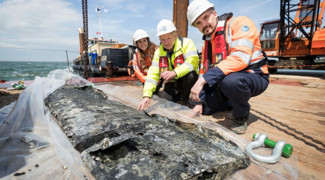
19th-Century Military Complex Unearthed in Canada

19th-Century Military Complex Unearthed in Canada

Workers on Parliament Hill dig through the remains of one of the three barracks used to house soldiers and their wives from 1826 to the late 1850s, during the initial stages of the Rideau Canal's construction.
Workers on Parliament Hill dig through the remains of one of the three barracks used to house soldiers and their wives from 1826 to the late 1850s, during the initial stages of the Rideau Canal’s construction. 

The remains of a military complex that predates both the Confederation and the foundation of Ottawa are buried under the flowers, trees and statues dotting Parliament Hill’s grounds.

Since April, an archeology team has been working to unravel the complex’s ruins as part of Center Block’s ongoing renovations.

What they’ve uncovered so far — barracks, an old guardhouse, and what was the former city of Bytown’s first jail — is just a small tidbit of what may be to come.

The complex contains the remnants of what existed on Parliament Hill before Centre Block was built, during the time the Rideau Canal was first being constructed.

“This was the headquarters for the entire canal construction for the soldiers,” said Stephen Jarrett, archeology project manager with Centrus, a consortium providing architectural and engineering services for the Centre Block rehabilitation project.

Coins, military tags, other items

The canal’s construction was overseen by Lt. Col. John By, for whom Bytown was named.

Three barracks, a guardhouse, a jail, stables, and cookhouses were all built on the north half of the hill starting in 1826 for the Royal Sappers and Miners Regiment, who were tasked with the backbreaking work of digging out more than 200 kilometers of earth from the Ottawa River to Kingston, Ont.

The items uncovered so far include a range of military items: chin straps, tags, gorgets  — which officers often wore to hold their neckties in place — and other domestic items, like coins.

Many of the items uncovered during the excavation date to the early 19th century, when time the Royal Sappers and Miners had a military complex on the hill during the construction of the Rideau Canal.
Two coins from 1813 and 1844 were uncovered on Thursday. 

Check the outhouses

But there might be more left to uncover, in a somewhat unusual spot: the privies.”It’s an excellent place to dispose of things,” said Jarrett.

The complex had several multi-chambered outhouses to accommodate the 150 soldiers, plus around 40 of their wives, who all lived in the barracks.

With no modern-day plumbing, it doesn’t take much to imagine the odour.”You need to keep the smell down from the human waste, and so you put fill layers on top in order to keep the smell down,” Jarrett said.”So that comes with all the broken dishes and anything else that can help keep that smell down.

Stephen Jarrett is the project manager for the excavation taking place on Parliament Hill.
Stephen Jarrett is the project manager for the excavation taking place on Parliament Hill. 

“One such latrine was built south of where the entrance to the Senate is now, near the east side of Centre Block. But there are likely many more dotting Parliament Hill.”

Privies fill up over time,” Jarrett said. “So they do get moved through time, as well.”

Ottawa’s first jail

Bytown became a city and was renamed Ottawa on New Year’s Day, 1855.

Before Ottawa became the country’s capital — or even a city, for that matter — it was a small town that didn’t have a jail. Prisoners had to be held at the courthouse in Perth, Ont., instead.

An 1853 map of Barrack Hill — now known as Parliament Hill — shows where the soldiers' barracks, officers' quarters, stables and guardhouse used to be.
An 1853 map of Barrack Hill — now known as Parliament Hill — shows where the soldiers’ barracks, officers’ quarters, stables and guardhouse used to be. 

The military had the only three cells in the community, located in the back of the jailhouse (which was later converted to a hospital).”The three cells were some of the only places to hold individuals properly,” Jarrett said. “So the military allowed the constables to hold prisoners inside their jailhouse until they were able to transport them all the way to [Perth].”Three years after Ottawa came into existence, it was named the capital of the United Province of Canada by Queen Victoria.

Soon afterward, the military complex was demolished so that the first parliament buildings could go up.

The excavation of the guardhouse and barracks is set to be completed by the fall. It’s expected to cost around $1.2 million and is being paid for by Public Services and Procurement Canada as part of the budget for the Centre Block renovations.

The artifacts will be cleaned and analyzed by the department before being put on display for the public.

A worker sifts through the remnants of the site of the old guardhouse and jail cells just east of Centre Block. A variety of items have been found there, including pins and chin straps.
A worker sifts through the remnants of the site of the old guardhouse and jail cells just east of Centre Block. A variety of items have been found there, including pins and chin straps. 

Rare Roman Coin Uncovered in England

An extremely Rare Roman Coin Uncovered in England

Dr Julian Bowsher examines the rare coin.
Archeologists working on the upgrade of the A14 between Huntingdon and Cambridge discovered an extremely rare coin showing a Roman emperor who reigned only for two months.
This is only the second coin of Emperor Laelianus to be discovered in England.

This is only the second coin of Emperor Laelianus to be discovered in England.

Ulpius Cornelius Laelianus ‘ “radiate” coin is only the second to be found and is named after the emperor’s radiate crown.

The find is important because Laelianus, who was killed in the siege of Mainz, ruled a breakaway empire from Rome for only a short spell in the 3rd century and there is little evidence of his reign.

Archaeologists believe the coin only arrived in Britain after the emperor’s demise.

Dr Steve Sherlock, archaeology lead for the A14 on behalf of Highways England, said: “Discoveries of this kind are incredibly rare.

This is one of many coins that we have found on this exciting project but to find one where there are only two known from excavations in this country that portray this particular emperor really is quite significant.

This Celtic coin dates back to around 57 BC, and would have likely helped fund the resistance to Caesar’s legions.

This Celtic coin dates back to around 57 BC, and would have likely helped fund the resistance to Caesar’s legions. 

“I look forward to seeing how the analysis of this find, along with numerous other Roman remains that we have found on this project, help us better understand our past.”The coin was found in a ditch on a small Roman farmstead.

Julian Bowsher, a coin specialist at archaeology firm MOLA Headland Infrastructure, said: “Roman emperors were very keen to mint coins.

Laelianus reigned for just 2 months, which is barely enough time to do so. However, coins were struck in Mainz, Germania.”

The fact that 1 of these coins ever reached the shores of Britain demonstrates remarkable efficiency and there’s every chance that Laelianus had been killed by the time this coin arrived in Cambridgeshire.”

An even older coin, dating back to 57 BC has been found on the A14 dig and it is believed to have come from France where it was thought to have been minted to help fund resistance to Julius Caesar.

Pioneering work on the A14 upgrade, which has seen archaeological excavations its 21 mile length, won the rescue project of the year award at the Current Archaeology Awards. Thousands of items of interest have been discovered.

The upgraded road is expected to open to traffic in December 2020.

Source: bbc

Playing Viking Chess with Whale Bones

Viking Chess Pieces May Reveal Early Whale Hunts in Northern Europe

Researchers discovered hnefatafl game pieces made of whale bone in upper- and middle-class Vendel graves.

In central and eastern Sweden from 550 to 793 CE, just before the Viking Age, members of the Vendel culture were known for their fondness for boat burials, their wars, and their deep abiding love of hnefatafl.

Also known as Viking chess, hnefatafl is a board game in which a centrally located king is attacked from all sides. The game wasn’t exclusive to the Vendels—people across northern Europe faced off over the gridded board from at least 400 BCE until the 18th century.

But during the Vendel period, love for the game was so great that some people literally took it to their graves. Now, a new analysis of some hnefatafl game pieces unearthed in Vendel burial sites offers unexpected insight into the possible emergence of industrial whaling in northern Europe. For most of the game’s history, its small, pebble-like pieces were made of stone, antler, or bone from animals such as reindeer.

But later, starting in the 6th century CE, Vendels across Sweden and the Åland Islands were buried with game pieces made of whale bone.

In the new research, Andreas Hennius, an archaeology doctoral candidate at Uppsala University in Sweden, and his colleagues traced the source of the whale bone by following a trail of evidence that led them to the edge of the Norwegian Sea about 1,000 kilometers north of the Vendels’ heartland in central Sweden.

Hennius thinks the whale bones used to make the game pieces were the product of early industrial whaling. If so, the pieces would be evidence of the earliest-known cases of whaling in what is today Scandinavia, and a sign of the growing trade routes and coastal resource use that paved the way for future Viking expansion.

To come to this striking conclusion, Hennius and his colleagues first had to find out where the whale bone was coming from. The Vendels weren’t whalers, Hennius says, so the pieces must have been imported. But from whom? The researchers also needed to confirm that the bone was the result of deliberate whaling, not just scavenged from stranded whales. To answer these and other questions, Hennius drew on genetic analysis, other archaeological finds, and ancient texts.

The first clue that the game pieces were indeed a sign of early industrial whaling emerged from genetic analysis of the whale bone. Though several whale species swam in Scandinavian waters, most hnefatafl pieces were made from North Atlantic right whale bones. This suggests the bones were the result of systematic hunting rather than opportunistic scavenging, Hennius says.

Other clues came from the Vendel graves. Whalebone game pieces first were only in the graves of a few wealthy people. But later, a flood of whale bone hnefatafl pieces appeared in the graves of regular folks. “Not the poorest graves, but the middle-class graves,” Hennius says. To him, it seemed like a rare, prestigious commodity suddenly became available to the mass market. And that implied regular, reliable imports—an industry.

Illustration by Mark Garrison

Illustration by Mark GarrisonEarly texts hinted at where that whaling industry might have been located, since it almost certainly wasn’t in the Vendel lands of central and eastern Sweden. The first known written record of whaling in Scandinavia describes a ninth-century Norwegian tradesman named Óttarr.

In his travels, he visited the royal courts of England, where records describe him bragging about his whaling prowess. Óttarr claimed that he and his friends caught 60 whales in two days near what is now Tromsø, Norway. Though Óttarr’s exploits date several centuries after the appearance of whale bone in Vendel graves, it suggests whaling may have been well established in northern Norway by the 800s CE.

It isn’t clear who was actually doing the difficult work of catching the whales, though it could have be any of the several groups of people living in northern Norway at the time, including the Sami. As for who was turning the whale bone into game pieces, that is also unknown. According to the researchers, it could have been the Sami or anyone along the long trade route south.

Hennius says further archaeological evidence also supports the idea of early whaling in northern Norway. Recently, other researchers discovered blubber rendering pits in the region, associated with the Sami, that date from about the time whale bone game pieces appeared farther south. The existence of these pits, Hennius says, implies the Sami were processing a steady supply of whales and not just the occasional stranding.

Hennius says all of this together—the Sami’s rendering pits, Óttarr’s exploits, the predominance of one species, and the presence of whale bone in middle-class graves—is “strong evidence that active whaling took place in northern Norway at this time,” and that the Vendels had established long-distance trade routes to ferry the material south.

Vicki Szabo, a historian at the University of North Carolina who studies medieval whaling across the North Atlantic, says Hennius and his colleagues make a good case for the existence of pre-Viking whaling in Scandinavia. “They’re linking ideas and trends that haven’t clearly been linked before,” she says.

Szabo’s own research suggests whaling in northern Norway was definitely feasible around 550 CE. After the collapse of the Roman Empire during the fifth century CE and the period of economic disruption that followed, it took time for societies across Europe to rebound. Szabo says whaling fits with a larger pattern of economic resurgence at the time.

As for the logistical challenges, Szabo says it’s unlikely these early whalers were out on the open ocean hunting whales from boats. Instead, hunters could have used poison-tipped spears, netted off narrow fjords, or driven whales onto shore.

Hennius is continuing to study the imported Vendel hnefatafl game pieces to see what else they can tell us about their origin and the trade routes on which they traveled. If the game pieces do, in fact, tell the tale of expanding coastal resource use in Norway, it is one of the first chapters in the dawning saga of Viking maritime dominance.

Related Stories from Hakai Magazine

Why this retired archeologist is convinced New Brunswick is home to a lost Viking settlement

Why this retired archeologist is convinced New Brunswick is home to a lost Viking settlement

Birgitta Wallace, a Parks Canada researcher, in Greenland.

Did Vikings visit New Brunswick’s Miramichi and Chaleur Bay areas? According to the research done by Birgitta Wallace, senior archaeologist emerita with Parks Canada, they did. 

“I’m really convinced that the Vikings did visit that area. Not all my colleagues would agree with me,” said the woman who’s been studying Vikings for 50 years.

While she is certain the Vikings did spend time in Miramichi and Chaleur Bay, she says she is not hopeful of ever finding anything to prove it.

Wallace said she determined that the second location that Vikings visited in North America, known as “Hóp,” meaning “tidal lagoon,” was in the Miramichi and Chaleur region after she studied the Vikings sagas. She also drew on her extensive work at L’Anse aux Meadows, located on the very northern tip of Newfoundland. 

Sagas tell Viking history

The sagas are contained in medieval documentation from Iceland that goes back to the oral history of the Vikings. They were not written down until 300 years after the actual events occurred, so Wallace said the oral telling of the stories may have changed a bit over time. “There are two separate manuscripts…that talk about voyages to what must be North America because it’s land west and south of Greenland.” 

Wallace said while Vikings settled on Iceland and then Greenland, they continued exploring — either by accident or intentionally – to new lands. “These were people who just settled in Greenland in 985. They were immigrating there from Iceland.” Wallace said when voyages began between Norway or Iceland and Greenland, it was inevitable that someone would get blown off course. She believes this is how they found North America. 

Two versions

The archaeologist said there are two versions of the story. One talks about Leif Erikson retracing the watery path of one of these off-course trips, but it only talks about one settlement where he built a base camp and made four expeditions. 

The other story features a different person and combines all the expeditions into one that go between two areas: “Hóp,” meaning “tidal lagoon,” a summer camp and a settlement further north described as being in fjord. 

Vikings settled at the L’Anse aux Meadows site on the northern peninsula of Newfoundland. 

“After working a lot with the  L’Anse Meadows and what we found there, it’s really clear that L’Anse Meadows is base camp…it fits with everything,” said Wallace. “And from that camp… we know they went farther south and we know they must have gone as far south as eastern New Brunswick.” 

Wallace believes those explorations were done through the Gulf of St. Lawrence, which would have led the Vikings to find the Miramichi and Chaleur regions. Wallace based her conclusions on the finding of pieces of wood, butternuts and butternut wood at the L’Anse Meadows camp.”And butternuts have never grown north of northeastern New Brunswick. They are not native to either P.E.I. or Nova Scotia, so New Brunswick is the closest location.” 

Description fits

Wallace said the descriptions in the sagas match that part of N.B. well. “It talks about sandbars outside the coast, rivers and wonderful hardwoods and not the least, wild grapes. And it so happens that butternuts grow in pretty much the same location as grapes and ripen at the same time,” she said.  

“So, whoever picked those nuts would have seen those grapes.”

Situated in Newfoundland and Labrador, L’Anse aux Meadows is believed to be where the the Vikings, the first Europeans, landed in the new world. In 1978 it became a UNESCO World Heritage site.

Wallace said the area would have been considered of great importance because it was called Vinland in the saga, which means wine land.”Vinland wasn’t one particular spot, it was land like Iceland and Greenland, a country or region.” 

The archaeologist says she believes about 40 men would spend 3 months exploring the region, sleeping in structures built with turf with no permanent roofs, just a canvas-like material.”And to find anything like that after 1,000 years, people that were very anxious I’m sure to take all their tools and belongings with them back, it’s not very likely that we can ever find particular, physical evidence like we do have in L’Anse Meadows.” 

Encounters with Indigenous inhabitants

But Wallace points out another strong indication the Vikings visited the area is found in the strong similarities of the descriptions in Leif Erikson’s saga and Jacques Cartier’s journal.

“It is exactly the same type of description.” Her belief is strengthened by the saga’s description of the Vikings encounters with most of the Indigenous inhabitants at “Hóp.” “That would fit this area very well,” she said.

Birgitta Wallace says the Vikings likely encountered the Indigenous inhabitants of Metepenagiag. 

“It would be the ancestors of Mi’kmaq and you have Red Bank, Metepenagiag which has been inhabited for 3,000 years or more.” Wallace is finding the sudden interest in this part of the story of the Vikings’ expedition humorous considering she’s been researching and writing about it for several years. She thinks an article she recently had published is the reason. “Somehow, it grabbed people’s attention,” she said with a laugh. “The interest in Vikings is astounding to me.” 

Source: nationalpost

Low Water Levels Reveal Riverboat Artifacts in Canada

Low Water Levels Reveal Riverboat Artifacts in Canada

These days, take a walk along the Yukon River in Whitehorse and you may spot things you rarely see — historical objects and structures typically well hidden under water or ice.

“Like, here is a log cradle, or a crib, used to support sternwheelers when they were pulled out of the river in the winter,” archeologist Ty Heffner of the Yukon government said as he walked along the river bank.

Water in the Yukon River system is very low this spring. Vast gravel bars flank the stream in many areas, and Heffner says lots of artifacts can now be seen in the mud and rocks.

That might include anything from old rusty nails and wooden logs and planks, to iron fixtures.  “If you think about all the activity that happened here, there were sternwheelers that were built here, there were sternwheelers that burned here.

There were warehouses and wharves and all kinds of activity — and the historical evidence here just relates to that,” Heffner said.

Government archeologist Ty Heffner says the artifacts can make for an interesting walk along the river, but people should be sure to leave what they find. 

“People can come down here and have a look at these items, and it just provides that tangible link to the past.” Murray Lundberg, an amateur historian in Whitehorse, says there’s a lot to see.

Most of what he calls the “good stuff” — things made of copper or brass — has likely been removed over the years, but there’s a lot of wood and steel all over the place.”

Anywhere there’s a calm spot, there’s a pretty impressive deposit of artifacts, still,” Lundberg said.”One of the problems we have right now is that nothing’s ever been cataloged because we’ve never seen the river this low — so it all has potentially significant historical interest.”

‘It all has potentially significant historical interest,’ said amateur historian Murray Lundberg. 

Lundberg says that’s why it’s best if people don’t pocket the things they find. “Collectors have done a lot of damage to sites like this — not just here, but everywhere,” he said.

According to Heffner, removing an object could also be an offense under Yukon’s Historic Resources Act.

‘People can come down here and have a look at these items, and it just provides that tangible link to the past,’ Heffner says. 

“People, you know, might not really think about that or realize that these are protected heritage resources and that they should not take it away,” Heffner said.”These pieces of our heritage are best left where they currently are.”

Source: vtn

Four Families Detected in Late Neolithic Burial in Poland whose Bodies Were Buried with Care

Four Families Detected in Late Neolithic Burial in Poland whose Bodies Were Buried with Care


Archaeologists found the remains of 15 people who were murdered about 5,000 years ago during the late Neolithic. Here’s what they may have looked like at the time of burial.

When 15 of them were brutally murdered — killed by vicious blows to the head— in what is now Poland about 5,000 years ago, an extended family met a grim end. But although these victims were violently killed, a new study shows that anyone who buried them did so carefully, placing mothers side by side with children and siblings.

In other words, it was far from random to place bodies in this burial. The burial shows “children next to parents, brothers next to each other[ and] the oldest person near the center,” said study co-lead researcher Niels Nørkjær Johannsen, a professor at Aarhus University’s Department of Archeology and Heritage Studies in Denmark.

Archaeologists learned about the late Neolithic burial during the construction of a sewage system in 2011, near the town of Koszyce in southern Poland.

The grave in Koszyce, southern Poland, holds the remains of 15 people and the grave goods that were buried with them.

This is far from the first large grave filled with ruthlessly murdered victims from the Neolithic; the remains of 9 brutally murdered people dating to 7,000 years ago are buried in Halberstadt, Germany, and 26 murdered individuals are buried in a 7,000-year-old “death pit” at Schöneck-Kilianstädten, Germany.

But the newly described burial is unique because the individuals were related to one another and weren’t buried haphazardly, according to a genetic analysis on the remains.”We are dealing with what you might call an extended family.

“We were able to show that there are four nuclear families present and emphasized in the burial, but these individuals are also related to one another across these nuclear families — for example, being cousins.”

The genetic analysis also revealed that the group, which was part of the Globular Amphora culture (named for their globular-shaped pots), had one male lineage and six female lineages, “indicating that the women were marrying from neighboring groups into this community where the males were closely related,” Johannsen noted.

It’s impossible to know who buried the victims, but whoever did wasn’t a stranger. “It is clear that lots of effort has gone into this [burial] and the people who buried them knew the deceased very well,” Johannsen said.


This graphic shows how the Neolithic victims were buried and how they are related to one another, according to a genetic analysis.

Even so, it’s interesting that these 15 people were buried together, rather than separately.”Perhaps the people who buried them were in a hurry?” Johannsen said. “But they nonetheless took care to bury individuals next to their closest family and also equipped the dead with funerary gifts, such as ceramic amphorae [jugs], flint tools, amber and bone ornaments.”

The burial doesn’t hold the remains of any of the family’s fathers, so maybe the victims were massacred when the fathers were away, Johannsen said. “[Perhaps] they returned later, found their families brutally killed and subsequently buried their families in a respectful way.”The massacre is tragic, but unsurprising given the time period.

During the late Neolithic, European cultures were being heavily transformed by groups migrating from the steppes, to the east. “We do not know who was responsible for this massacre, but it is easy to imagine that the demographic and cultural turmoil of this period somehow precipitated violent territorial clashes,” Johannsen said.

The finding is remarkably similar to 4,600-year-old burials from the Corded Ware culture (named for their corded pottery designs) found near Eulau, Germany. At that site, “violently killed people were also carefully buried according to their familial relationships,” said Christian Meyer, a researcher at OsteoARC, Germany, who was not involved in the study but who has worked on several other sites of Neolithic mass violence.

If anything, the Koszyce burial “is further evidence that lethal mass-violence events occurred at times throughout the Neolithic of Europe,” Meyer said. “These events could be catastrophic for the targeted communities, which were apparently built upon overlapping social and biological kinship ties.

“However, while the researchers of the new study call the Koszyce finding a “mass grave,” Meyer said he sees it differently. “The people were buried very carefully, received grave goods and were positioned according to their immediate kinship ties,” he said. “We should maybe call this a large ‘multiple burials’ rather than a ‘mass grave,'” in which bodies are typically buried in a disorganized heap.

Source: archaeology.org

Ivar the Boneless | Viking Leader & Commander of Great Heathen Army who Conquered Much of England

Ivar the Boneless | Viking Leader & Commander of Great Heathen Army who Conquered Much of England

Starting with the 793 AD attack on Lindisfarne’s island monastery, Viking raids on England had become almost routine, but this changed for the worse in 865 AD, and the English faced what they called “The Great Heathen Army.”

This was an invasion force of 1000,s of Norse warriors, most of them from Denmark, but others from Norway, Sweden, and Ireland, and under the command of Ivar the Boneless and his brothers, Halfdan and Ubba, who had made their names in Ireland fighting for Olaf the White, ruler of the Viking Kingdom of Dublin, in the 850s.

England in the 9th century was divided between four major Anglo-Saxon kingdoms — Northumbria in the north, Mercia in the middle of the country, East Anglia in the east, and Wessex covering much of the south.

By the time of Ivar’s end sometime after 870, Viking territory in England, called “the Danelaw”, covered the bulk of Northumbria, Mercia, and East Anglia.

“Hyngwar”, Ivar’s name as it appears in Harley MS 2278, a 15th century Middle English manuscript.
“Hyngwar”, Ivar’s name as it appears in Harley MS 2278, a 15th century Middle English manuscript

Norse influence stretched from the River Tees to the River Thames, shaping the language, culture, and geography of the north and east of the country. This was down to the leadership of a warrior chief who struggled to walk, but according to legend had to be carried into battle on an upturned shield.

The kingdom of Ivar (outlined in red) and the territories paying him tribute (outlined in purple).

According to Norse mythology, Ivar the Boneless was born with “only cartilage was where bone should have been, but otherwise, he grew tall and handsome and in wisdom, he was the best of their children.” His father was said to be Ragnar Lodbrok, the main character in the first 4 seasons of Vikings, and as punishment for forcing himself on the mother, the sorceress (or völva) Aslaug, their child was cursed with deformity.

Lothbrocus and his sons Ivar and Ubba. 15th century miniature in Harley MS 2278, folio 39r.

Many believe Ragnar, who is played by Travis Fimmel in the show, to be a fictional character. He’s a sort of every(North)man narrator who is used in order to contextualize important events in Viking history. It’s a way of binding together folk tales and oral histories from different regions, eras, and traditions as the Norse world expanded through exploration and conquest.

Some modern theories are that Ivar could have suffered from osteogenesis imperfecta (brittle bone disease), that he was double jointed, or that rather than being literally boneless, there’s a line in the 13th century saga Ragnarssona þáttr (Tale of Ragnar’s Sons) that suggests it may be a euphemism for his impotence.

The sagas offer more noble and heroic reasons for the invasion by the Great Heathen Army, suggesting that Ivar the Boneless and his brothers were simply avenging the betrayal and killing of Ragnar by the lowborn King Ælla of Northumbria, but that’s most likely an attempt to retrospectively give the invaders a more noble motive than mere plunder.

A modern artist’s interpretation of the reputed execution of Ragnar Lodbrok

Even if Ragnar were a real historical figure, it doesn’t seem hugely likely that Ælla kept a pit of venomous snakes to have his captives thrown into like a supervillain, especially given there are no species of snake in the British Isles that are lethal to humans. It’s much more plausible that the “betrayal” and the snake pit are allegories, as Ælla was regarded by his peers as a usurper, who had displaced the true king, Osberht, giving Norse storytellers a convenient bad guy for their own tales.

The Great Heathen Army did, however, turn on Ælla of Northumbria first. Landing in East Anglia to little resistance, they marched north to capture York in 866. This would be the capital of their new English domain. Ælla, and his predecessor Osberht, faced the greater threat together and were killed in battle near York in March 867 and replaced with a puppet king, Ecgberht I, who accepted Viking rule of the territory taken by Ivar the Boneless.

A map of the routes taken by the Great Heathen Army from 865 to 878.
A map of the routes taken by the Great Heathen Army from 865 to 878. 

The sagas give different, more poetic interpretations of these events. They claim that Ivar went to broker peace with Ælla and took York from him using his greater cunning. Asking for compensation from the King of Northumbria for the murder of his father, Ivar said he would take whatever land he could cover with a piece of ox hide.Ælla, thinking his opponent could do little harm with a patch of Northumbria, agreed.

Ivar then cut the leather into thin strips that he could stretch around a parcel of land big enough to settle the city of York. (As York had already been an important Roman and then Anglo-Saxon city, this is most likely nonsense.)

Having subdued their northern neighbors, the Great Heathen Army then turned west and south and invaded the Kingdom of Mercia and then, eventually — after buying time with a peace treaty he had no intention of honoring — the Kingdom of East Anglia. King Edmund of East Anglia was defeated in battle and according to Anglo-Saxon sources is done away with for refusing to turn his back on Christianity.

While his kin launched an ultimately unsuccessful invasion of the Kingdom of Wessex, Ivar the Boneless returned to Ireland and joined his old ally Olaf the White in a raid on Dumbarton, the capital of the Celtic (or Brythonic) Kingdom of Strathclyde on the west coast of Scotland. Returning to Dublin in triumph with loot and slaves, Ivar the Boneless died sometime after 870, with one source giving the date as 873.

Silver penny of Æthelred I, King of Wessex (865–871)

Silver penny of Æthelred I, King of Wessex (865–871)

“The Norwegian king […] died of sudden hideous disease,” recorded the 11th-century Fragmentary Annals of Ireland cheerfully. “Thus it pleased God.”

Some historians believe that it may have been a result of his deteriorating condition, but until an archaeologist stumbles across his distorted bones buried beneath an unassuming Irish hillside, there’s simply too little detail and too much mythology to know for certain. What we do know, is in fewer than ten years Ivar the Boneless left a mark on history that can still be seen in Norse place names, dialect words, folklore, and on our TV screens.

Inside The Mysterious Gobekli Tepe, The Oldest Temple In The World

Inside The Mysterious Gobekli Tepe, The Oldest Temple In The World

More than 200 carved stone pillars, carefully arranged in tightly packed circles, stood proudly on the Göbekli Tepe hill in southeastern Anatolia (modern Turkey).

This ancient stone circle, thought to be a Neolithic temple, is 6,000 years older than Stonehenge and much more complex. This is the site some historians call the twentieth century’s most important archeological find and the first temple in the world.

According to Smithsonian Magazine, Göbekli Tepe was first discovered in 1994 by Klaus Schmidt of the German Archaeological Institute. The area around the site had long been earmarked for further investigation, as its dome-shaped hill bore all the signs of a “tell”, a mound created as a result of the deposits of ancient settlements.

Schmidt quickly realized that the site at Göbekli Tepe was far more significant than the medieval burial site hypothesized by earlier archaeologists. In an interview with Andrew Curry for Smithsonian Magazine, Schmidt explained that it didn’t take his team long to uncover the first series of stone megaliths, close to the surface.

Digging deeper, the archaeologists unearthed more pillars, decorated with elaborately carved figures. These immense standing stones were arranged in circles and would have supported additional huge stone blocks, some of which weighed more than 10 tons.

Erecting these stone pillars and placing such heavy blocks on top of them would have required an immense feat of engineering. Yet the site was constructed in 9,500 BC, thousands of years before the development of written language and agriculture, and well before human beings began to develop permanent settlements and cities.

Pillar 2 from Enclosure A (Layer III) with low reliefs of what are believed to be a bull, fox, and crane. 

“This is the first human-built holy place,” said Schmidt. The archaeologists were able to date Göbekli Tepe by comparing weapons and tools found at the site to similar objects from the 10th millennium BC, and their hypotheses were later confirmed by partial radiocarbon dating.

Pillar 27 from Enclosure C (Layer III) with the sculpture of a predatory animal

The team found no traces of human settlement around the site: no remains of houses, ovens or trenches for rubbish. Instead, they found many animal bones within the temple, which bore the signs of having been butchered and cooked. All of the animal bones excavated came from local game, predominately gazelle, boar, sheep, deer and wild fowl, which suggests that the people who made and used the site were nomadic hunter-gatherers.

Pillar with the sculpture of a fox.

The discovery of Göbekli Tepe has major implications for our understanding of the way in which early human societies developed. Traditional scholars have long maintained that the development of sophisticated human society was contingent on the transition from a hunter-gatherer to agrarian way of life.

According to this narrative, it was only once humans had developed permanent settlements and systems of agriculture and farming that they were able to have the time, organization and resources to develop temples and complicated social structures.

Although this theory has been challenged by archaeologists and anthropologists in recent decades, the discovery of Göbekli Tepe finally provides hard evidence to support an alternative point of view. Nomadic, hunter-gatherer societies in Anatolia constructed large, complex temples before they developed agricultural practices and formed permanently settled communities.

View of excavations at Göbekli Tepe site. 

Indeed, according to Smithsonian Magazine, in the 1,000 years following the construction of the temple, permanent settlements do appear in other parts of Anatolia and northern Syria, providing some of the earliest evidence for the cultivation of wheat crops and the domestication of cattle. It is possible that the construction of the temple at Göbekli Tepe was actually the precursor for human settlement and agriculture, not the other way around.

Archaeological work in Göbekli Tepe

However, the specific function of the site at Göbekli Tepe remains a mystery. Until his death in 2014, Schmidt remained convinced that it was an important religious temple, and his view is supported by the elaborate carvings on the pillars. These include images of scorpions, lions, snakes, and vultures, a collection of symbols that are associated with religion, death and the afterlife in other ancient cultures of the Near East.

The site could also have been used as a place for political gatherings or cultural celebrations, but Schmidt argued that it was more likely to have been a burial place for renowned hunters.

All In One Magazine