Remarkably Well-Preserved 2,500-Year-Old Canoe Discovered In Swiss Lake
Archaeologists have discovered a remarkably well-preserved dugout canoe from the Early Iron Age in Lake Neuchâtel in western Switzerland.
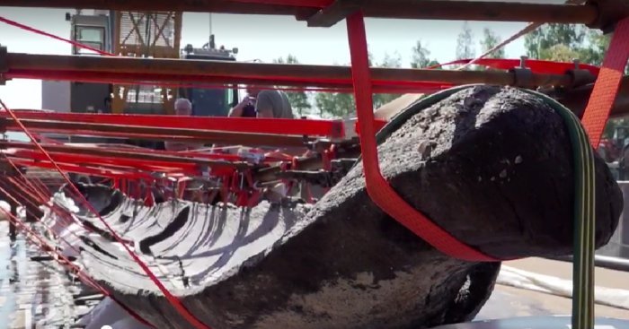
According to the Vaud canton’s archaeology department, the 13-meter-long canoe was resting at a depth of 3.5 meters on a sandbank on the north shore of the lake.
After months of careful preparation, scientists could lift the canoe and pull it out of the lake.
Experts assisted the cantonal archaeologists in underwater salvage techniques. This delicate operation required many months of preparation.
“This is an archaeological discovery of considerable importance for our understanding of the prehistory of the region.
Its radiocarbon analysis dates it to between 750 and 520 B.C., a time when there were no villages on the shores of the lakes.
The old canoe is still, despite its age, in good condition.
It is one of the very few boats from this period in Switzerland that has been preserved almost in its entirety,” said cantonal archaeologist Nicole Pousaz at the press conference.
The canoe has now been transported to a lab for special analysis. Archaeologists examine it to see what clues it holds to life during this time.
Photogrammetry and laser measurements will also be used to create a 3D model of what the canoe would have looked like, fully intact.
The canoe will be carefully transported to a specially equipped facility for in-depth study.
“She’s a very sickly old lady. Part of the sides of the canoe were torn out by storms, and the portion buried in the sediment was very cracked. It’s a very fragile object,” Jean-Daniel Renaud, who runs a company specializing in the technical aspects of underwater and terrestrial archaeology, told the press agency Keystone-SDA.
“It was made at the time from an oak trunk about 13 meters long and about a meter in diameter.
This type of canoe, which was particularly large, was mainly used for transporting goods and people or for fishing,” added Renaud.
According to the specialist, it is one of the largest and most complete canoes of its kind to have been discovered in Switzerland.
Huge Ancient Sarayini Underground City Is Twice As Large As Previously Thought
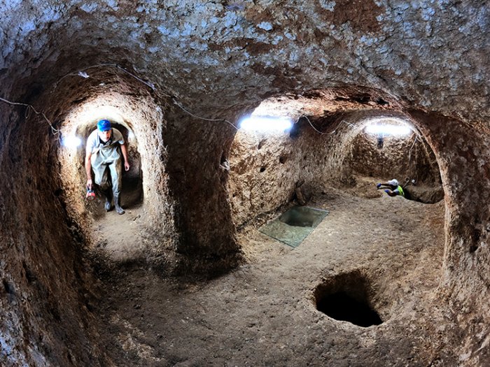
Scientists knew the ancient underground city they examined was huge, but now it’s obvious it’s twice as large as previously thought! What secrets does this mysterious ancient place hide? How many underground tunnels, galleries, chambers, and unknown rooms still await discovery?
The ancient Sarayini underground city covers at least 20,000 square meters. Image credit: Anadolu Agency (AA)
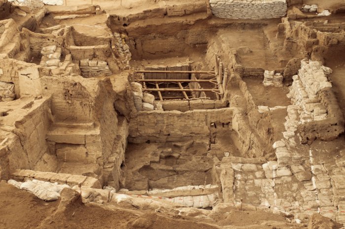
The ancient underground city in Sarayönü, a district of Konya in Turkey, dates back to the Roman period. When first examined by archaeologists, it was thought the subterranean city covered an area of 5000 m2, but a recent investigation reveals this enigmatic ancient place is at least 20,000 square meters, if not even more!
In co-operation with the Ministry of Culture and Tourism and Sarayönü Municipality, scientists are investigating the ancient underground city for the second year.
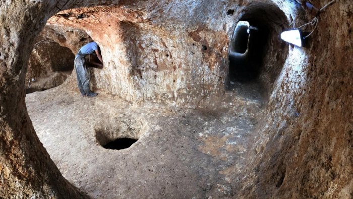
What has been discovered so far is fascinating. There are dozens of underground rooms connected to each other by tunnels of different lengths and widths. Many corridors, tunnels, and galleries are still waiting to be cleaned, so it is currently difficult to determine where they lead.
Is Sarayini Turkey’s Largest Underground City In Horizontal Architecture?
The history of the subterranean place, which includes domestic spaces, connected galleries, room-like living spaces, water wells, furnaces, workshops, chimneys, oil lamps for lighting, cellars, warehouses, ventilation, and spaces whose quality has yet to be investigated, dates back to the 8th century.
Hasan Uguz, archaeologist and head of excavations of Konya Museums Directorate, said that based on the findings, scientists determined that “the local Christian people used the underground city in the 8th century to protect themselves from the raids that lasted for 150 years” the Konya News reports.
Uguz explained that elderly people who had lived here all their lives used to play in the tunnels as children. Locals knew a very large underground city was here, but no one could even guess how vast it was. Scientists did not think the underground tunnels, corridors, and rooms could spread over such a large area.
Uguz said it is possible this is the largest underground city in Turkey ever discovered in horizontal architecture.
“We may have found one of the largest underground cities in Central Anatolia. The rumors of the people of the region and the collapses in different places show us that the underground city can spread over a very wide area and that it can be a very long tunnel system.
The openings and dents we caught give positive signals at this point. It is an important historical and tourist discovery, as no other underground city is known in the region,” Uguz told the Konya News.
Ancient Sarayini Underground City Was A Comfortable Place
“In our research, we noticed that 19th-century European travelers refer to this region as Sarayini. The people living here also say this. The real name of this place is Sarayini. It has been determined that the caves resemble a palace because of their very spacious, comfortable, interconnected, and high-quality-of-life architecture, and in this sense, it is called Sarayini,” Uguz told the Anadolu Agency.
The archaeologists explained that scientists discovered a very wide corridor resembling what could be best described as a main street. On the left and right sides of the corridor were galleries connected by tunnels and other corridors.
The ancient underground city gives the impression of being prepared for people to live as comfortably as possible, almost like residing in a palace.
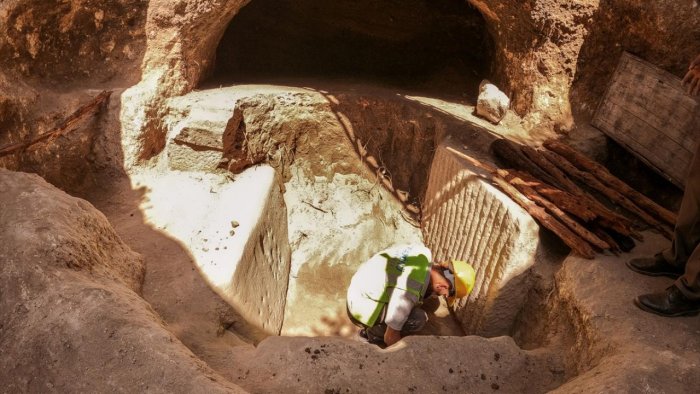
In an interview with the Anadolu Agency, Uguz said the archaeological investigations continue. During excavations, the science team discovered altar-type tombstones, tomb stelae made in the Roman period, sophisticated artificial walls built, and a north-south oriented structure reminiscent of a wooden cross.
Uguz explained that the underground city’s human capacity and exact size will become clear as the work progresses.
Soil currents coming from some submerged places with water filled the spaces between 30 and 80 cm. After the spaces are cleaned and exposed, the capacity and size of human accommodation will become clear. There are domestic spaces and interconnected galleries that excite us.
The most important thing for us is the discovery of this place and the start of the work. This underground mystery, how people lived here, how these places were created at that time attracts attention,” Uguz said.
This Is One Of The Oldest Pieces Of Cloth In The World And It’s Made Of Bast Fibers!
Archaeological discoveries provide us with vital information about the daily life of our ancestors. What did ancient people eat and drink, and what kind of clothes did they wear? These are some of the many questions occupying the minds of those interested in ancient history.
Scientists have discovered incredible textiles that have survived for thousands of years and can now be analyzed with the help of modern technology.
Neolithic Site of Çatalhöyük.
At La Marmotta near Rome, Italy, underwater archaeologists found rare and well-preserved cloth fragments produced by people more than 8,000 years ago. Scientists are especially impressed with four extraordinary small textile fragments that researchers at the University of Copenhagen are currently analyzing. The Neolithic textiles were most likely made of plant fibers.
While excavating at Giza, Egypt, archaeologists discovered the only complete ancient Egyptian bead-net dress found to date in one of the tombs!
The 4,500-year-old dress was comprised of “several thousand faience beads divided among thirty small, rounds boxes of varied sizes, none larger than five inches in diameter.”
“This individual was wrapped, each limb individually, to simulate a living person, and covering her was the front half of a narrow V-necked sheath. Our final bead-net reconstruction produced, therefore, not a shroud-like mummy covering, but rather a dress that simulated a garment actually worn in life,” Millicent Jick at the Museum of Fine Arts in Boston said.
Another incredible Egyptian discovery is the Tarkhan Dress, a V-neck linen shirt that has been confirmed as the world’s oldest woven garment, with radiocarbon testing dating the garment to the late fourth millennium B.C.
Glacial archaeologists have also successfully recovered amazing clothes and shoes that have been buried under the ice in Norway for a very long time. At the Lendbreen, a pass high in the Norwegian mountains, scientists found two complete pieces of clothing. One of them is a 1,700-year-old tunic.
The Lendbreen tunic is Norway’s oldest piece of clothing, and despite being hidden beneath the snow for so many years, it’s still very well-preserved.
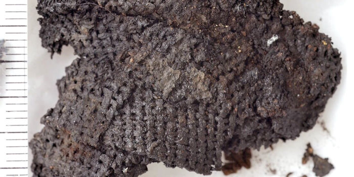
One of the world’s oldest pieces of cloth was unearthed in Çatalhöyük, Turkey. This archaeological discovery of Stone Age textiles sheds new light on the history of clothes making.
Çatalhöyük, is the world’s largest known Stone Age settlement and one of the most famous archaeological sites. As many as 10,000 people lived in Çatalhöyük in Turkey some 8,000-9,000 years ago. This makes it the largest known settlement from what archaeologists call the Neolithic and Chalcolithic periods.
Ever since the first discovery of pieces of cloth unearthed at the site, experts have been discussing what kind of clothes people wore in Çatalhöyük. Some specialists believed that people made their clothes from wool. Others thought they made them out of linen instead. So who’s right? Neither, actually.
This piece of cloth is from the Stone Age. For 60 years, academics have debated whether it is made of wool or linen. So what is it really made of? The answer will surprise you. Credit: Antoinette Rast-Eicher, University of Bern
As explained by Bender Jørgensen, a specialist in archaeological textiles and Professor emerita from NTNU’s Department of Historical and Classical Studies, “In the past, researchers largely neglected the possibility that the fabric fibers could be anything other than wool or linen, but lately another material has received more attention.”
People in Çatalhöyük used assorted varieties of exactly this material.
“Bast fibers were used for thousands of years to make rope, thread, and in turn also yarn and cloth,” says Bender Jørgensen.
As it turns out, people in this area did not import linen from elsewhere, as many researchers have previously thought, but used the resources they had plentiful access to.
Bender Jørgensen notes that a lot of people often overlook bast fiber as an early material. “Linen tends to dominate the discussion about the types of fabric fibers people used,” she says.
People in Çatalhöyük used oak bark, but bast fibers can also be collected from other plants. Here we see Jute, a natural vegetable bast fiber that is obtained from the bark of the jute plant. Jute is known as the Golden Fiber because of its golden color.
Ancient civilizations were resourceful and highly creative. Producing textiles made of bast fibers had several advantages. Bast fiber is found between the bark and the wood in trees such as willow, oak, or linden. The people from Catalhöyük used oak bark and thus fashioned their clothes from the bark of trees that they found in their surroundings.
Possible 400-Year-Old Ritual Objects From Egypt Identified
‘People in the Early Ottoman Period consulted popular sorcerers, alongside their formal belief in the official religion, say the Israeli archeologists
Itamar Taxel, Israel Antiquities Authority. The excavation area in the Eilat hills of Israel.
The Israel Antiquities Authority (IAA) released on Monday archeological findings of “magical” artifacts on the Darb al-Hajj pilgrimage route from Egypt to Saudi Arabia, which passed through the Sinai Peninsula.
The assemblage of artifacts was first discovered in the 1990s in the Eilat region, near the Red Sea. The team of Israelis analyzed the rare collection of objects, and determined that they were used for magic rituals about 400 years ago, “to ward off the evil eye, to heal diseases and more.”
“This discovery reveals that people in the Early Ottoman Period—just as today—consulted popular sorcerers, alongside the formal belief in the official religion,” said Dr. Itamar Taxel of the Israel Antiquities Authority and Dr. Nitzan Amitai-Preiss of the Hebrew University of Jerusalem.
Clara Amit, Israel Antiquities Authority. A clay female figurine was found at the excavation area in the Eilat hills of Israel.
The archeologists said the objects may have been broken purposely during the ceremonies, describing one of the objects as “fragments of clay globular rattles, mostly similar to table tennis balls, containing small stones that sound when the rattle was shaken.”
Clara Amit, Israel Antiquities. AuthorityColored quartz pebbles were found at the excavation area in the Eilat hills of Israel.
In addition, there were two artifacts “similar to miniature votive incense altars,” as well as figurines, particularly of a naked woman “or a goddess with raised hands, a characteristic feature of deities or priests,” and some colored quartz pebbles.
“This is the first time that such a large assemblage of ritual objects of this kind has been found, and it is even more unique at a temporary site and not a permanent settlement,” the researchers stated, describing the material as coming from Egypt.
Clara Amit, Israel Antiquities AuthorityClay rattle fragment found at the excavation area in the Eilat hills of Israel.
The location where the artifacts were found was next to Darb al-Hajj pilgrimage road that started in Cairo and wound through the Sinai Peninsula into the Arabian Peninsula.
The road was used from the 7th century CE — the advent of Islam — until the 19th century CE.
“The road and adjacent archaeological sites are to become part of a unique regional archaeological-touristic area promoted by the Ministry of Tourism,” Dr. Omry Barzilai, Southern Regional Archaeologist of the Israel Antiquities Authority, said about the special site.
Uzi Avner, Dead Sea-Arava Science Center. Part of the Darb al-Hajj pilgrimage route in the Eilat mountains of Israel.
The research was recently published in the Journal of Material Cultures in the Muslim World.
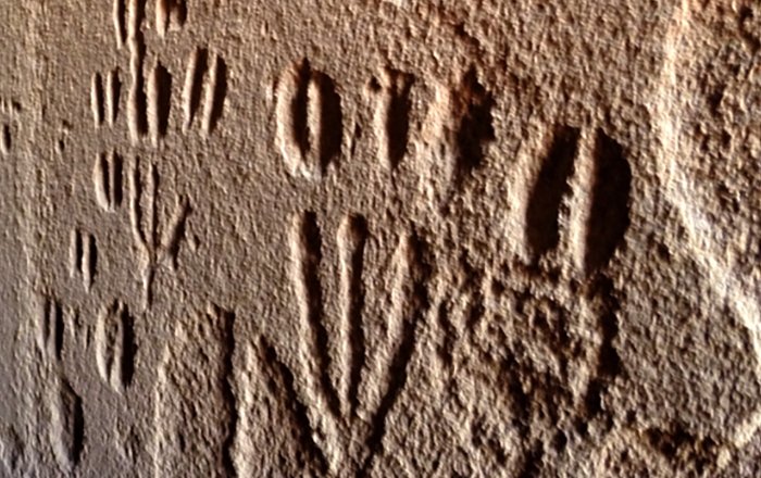
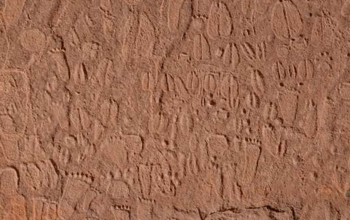
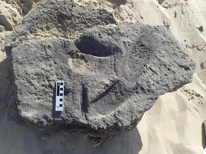
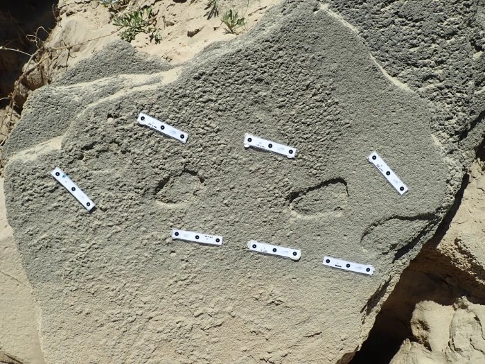
Animal Tracks And Human Footprints In Prehistoric Hunter-Gatherer Rock Art In Namibia
Namibia is rich in hunter-gatherer rock art from the Later Stone Age (LSA); this is a tradition of which well-executed engravings of animal tracks in large numbers are characteristic.
Hidden panel of the RAS 8 rock art site. The narrow corridor RAS 8-N, with engravings on both sides which extend as far inside as the lower exfoliated rock face; from the position of the photographer at the entrance, this is situated roughly three metres into the corridor (photograph: T. Lenssen-Erz).
The sites examined in this study are located in the Doro! nawas mountains of Namibia, and have abundance of track engravings on single panels.
A recent research project, from which this article has emerged, has attempted to fill the research gap; it entailed indigenous tracking experts from the Kalahari analysing engraved animal tracks and human footprints in a rock art region in central Western Namibia, the Doro! nawas Mountains, which is the site of recently discovered rock art.
In this study, the researchers defined the species, sex, age group and exact leg of the specific animal or human depicted in more than 90% of the engravings they analysed (N = 513).
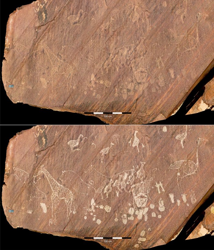
Exceptional panel from the RAS 6 rock art site. RAS 6-C is the most visible panel of RAS 6, featuring depictions of extraordinarily detailed giraffes and ostriches (above: engravings in their original condition; below: digitally enhanced images of the engravings; photographs and artwork by P. Breunig).
Their work further demonstrates that the variety of fauna is much richer in engraved tracks than in depictions of animals in the same engraving tradition.
The analyses reveal patterns that evidently arise from culturally determined preferences. The study represents further confirmation that indigenous knowledge, with its profound insights into a range of particular fields, has the capacity to considerably advance archaeological research.
Stone Age depictions of human footprints and animal tracks in Doro Nawas Mountains, Namibia. Credit: Andreas Pastoors
Prehistoric hunter-gatherers arguably depended for their survival on their ability to draw as much information as possible from the tracks of animals and people. As much as prehistoric rock art itself is a global phenomenon, so is the occurrence of tracks within the spectrum of motifs.
Among the 513 tracks analyzed in total, the experts identified 345 quadrupeds and 62 bird tracks (407 in total from 40 different species; Rhinoceros sp. is listed as a taxon, but not counted as a separate species).
We divide these into a group of ’frequently’ depicted species (10 depictions or more), a second group of ‘less frequently’ depicted species (between 3 and 9 depictions), and a group of ’rarely’ depicted species (one or two specimens only). The animal track engravings encompass 39 species, including herbivores, felines, other predators, birds and primates.
Doro! nawas is an area of about 50 x 30 km directly west of the World Heritage Site /Ui//aes-Twyfelfontein. Ui//aes-Twyfelfontein is considered to be among the largest rock engraving sites in sub-Saharan Africa, with a rich variety of motifs.
The sites at Doro! nawas located only a few kilometres to its west add considerably to this range; they include several large depictions of humans and particularly large naturalistic engravings of elephants, neither of which occur at all at the World Heritage Site. It is the area’s wealth of animal track engravings that makes it an ideal subject for the present study.
Paper – “Animal tracks and human footprints in prehistoric hunter-gatherer rock art of the Doro! nawas mountains (Namibia), analysed by present-day indigenous tracking experts.”
New Discovery Reveals Why And When The Sahara Desert Was Green
A pioneering study has shed new light on North African humid periods that have occurred over the past 800,000 years and explains why the Sahara Desert was periodically green.
The research, published in Nature Communications, showed periodic wet phases in the Sahara were driven by changes in Earth’s orbit around the sun and were suppressed during the ice ages.
For the first time, climate scientists simulated the historic intervals of ‘greening’ of the Sahara, offering evidence for how the timing and intensity of these humid events were also influenced remotely by the effects of large, distant, high-latitude ice sheets in the Northern Hemisphere.
Lead author Dr. Edward Armstrong, a climate scientist at the University of Helsinki and University of Bristol, said, “The cyclic transformation of the Sahara Desert into savannah and woodland ecosystems is one of the most remarkable environmental changes on the planet.”
“Our study is one of the first climate modeling studies to simulate the African Humid Periods with comparable magnitude to what the paleoclimate observations indicate, revealing why and when these events occurred.”
There is widespread evidence that the Sahara was periodically vegetated in the past, with the proliferation of rivers, lakes and water-dependent animals such as hippos, before it became what is now desert.
These North African Humid Periods may have been crucial in providing vegetated corridors out of Africa, allowing the dispersal of various species, including early humans, around the world.
The so-called “greenings” are thought to have been driven by changes in Earth’s orbital conditions, specifically Earth’s orbital precession. Precession refers to how Earth wobbles on its axis, which influences seasonality (i.e., the seasonal contrast) over an approximate 21,000-year cycle. These changes in precession determine the amount of energy received by the Earth in different seasons, which in turn controls the strength of the African Monsoon and the spread of vegetation across this vast region.
A major barrier to understanding these events is that the majority of climate models have been unable to simulate the amplitude of these humid periods, so the specific mechanisms driving them have remained uncertain.
This study deployed a recently-developed climate model to simulate the North African Humid periods to greatly advance understanding of their driving mechanisms.
The results confirm the North African Humid Periods occurred every 21,000 years and were determined by changes in Earth’s orbital precession. This caused warmer summers in the Northern Hemisphere, which intensified the strength of the West African Monsoon system and increased Saharan precipitation, resulting in the spread of savannah-type vegetation across the desert.
The findings also show the humid periods did not occur during the ice ages, when there were large glacial ice sheets covering much of the high latitudes. This is because these vast ice sheets cooled the atmosphere and suppressed the tendency for the African monsoon system to expand.
This highlights a major teleconnection between these distant regions, which may have restricted the dispersal of species, including humans, out of Africa during the glacial periods of the last 800,000 years.
Co-author Paul Valdes, Professor of Physical Geography at the University of Bristol, said, “We are really excited about the results. Traditionally, climate models have struggled to represent the extent of the ‘greening’ of the Sahara. Our revised model successfully represents past changes and also gives us confidence in their ability to understand future change.”
Changes of vegetation between humid and arid phases in North Africa. Vegetation zones are based on the minimum precipitation requirements of each vegetation type.
The research, including climate scientists from the University of Birmingham, is part of a project at the University of Helsinki, which studies the impacts of climate on past human distributions and evolution of their ecological niche.
Co-author Miikka Tallavaara, Assistant Professor of Hominin Environments at the University of Helsinki, said, “The Sahara region is kind of a gate controlling the dispersal of species between both North and Sub-Saharan Africa, and in and out of the continent.”
“The gate was open when Sahara was green and closed when deserts prevailed. This alternation of humid and arid phases had major consequences for the dispersal and evolution of species in Africa.
Our ability to model North African Humid periods is a major achievement and means we are now also better able to model human distributions and understand the evolution of our genus in Africa.”
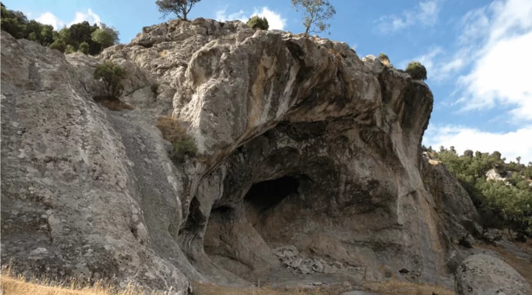
8,000-year-old Cave paintings found in Türkiye’s İnkaya Cave depict life and death
A number of cave paintings dating back some 8,000 years have been found in İnkaya cave in the Marmara province of Balıkesir during a field study conducted by Associate Prof. Dr. Derya Yalçıklı from Çanakkale (18th March) University, in 2015.
During the same studies, another cave located 5 kilometers away from the İnkaya cave was discovered. The discovery of both caves is known as the most important archaeological discovery made in Anatolia in recent years.
The cave paintings discovered in the Baltalıin and İnkaya Caves, which are situated in the Delice neighborhood of the Dursunbey district in the Balıkesir province of Turkey, offer information that sheds light on Neolithic Age life.
One of the remarkable findings showing that people in the Prehistoric Age were undeniably knowledgeable about the phenomenon of childbirth is the scene found among the cave paintings of İnkaya Cave.
The painting depicts a woman becoming pregnant, the pregnancy, and childbirth in an expression that has yet to be matched.
The western part of the panel, which is well-preserved and situated close to the entrance of the İnkaya cave, constitutes the main scene of the picture.
When Baltalıın and İnkaya caves were analyzed separately, it was revealed they were used for different functions, as the paintings in one of them depicted hunting figures, while the other depicted figures of beliefs. The paintings found in the two caves date back to the Late Neolithic period.
Associate Professor Derya Yalçıklı, who discovered and examined the cave paintings, told Arkeonews in an email, “Social and belief systems in Western Anatolia during the Neolithic and Chalcolithic periods constitute an important question of Anatolian archeology, and examining the wall paintings in Baltalıin and İnkaya caves may provide some important answers.”
The floor and northern wall of the İnkaya Cave were greatly damaged by past treasure hunters using dynamite, however, despite this damage, the cave continues to reflect important information about the Neolithic era.
Southwestern painting.
Inkaya Cave is located 2.5 km northwest of Delice neighborhood. The cave, with its karstic quality, consists of a gallery that is 4.5 m deep, 8 m wide, and 4.4 m high. It features two murals located on the northern and southeastern outer edges of the cave entrance.
The panel located on the left side (southwest) of the cave entrance measures 1.43×0.87 meters. There are also four people dancing in the main part of the painting on the left side of the entrance.
A different depiction of a human wearing fur on the right side of two women and two men is depicted, while on the left side of this painting, there is a depiction of a fetus growing in the womb.
Across from a human wearing fur, a human is depicted with a snake behind. It was believed that the snake represents death in this figure, which was interpreted as “the moment of death” by the experts.
The depiction of a human wearing fur and extending his hand forward is believed to be a shaman who is helping human spirits to go to the land of the dead at the moment of death. A portrayal of a dead human without a head offered to the vultures is also depicted.
Detail of southwestern painting.
Life and death are the themes of the cave paintings in İnkaya Cave. The panels representing Life are based on the formation of a fetus inside a pregnant woman’s abdomen, its development, and birth, as well as the celebration of a new individual joining the community, with an emphasis on the shaman’s role throughout this process.
In cave paintings, reliefs, and figurines from the Neolithic period in Anatolia, scenes of sexuality, pregnancy, and childbirth are presented to the viewer from various angles.
The successful use of the “X-ray” style -The rays pass through the painting and create a negative of the darker areas on film- in the creation of the İnkaya Cave painting in the Neolithic period fills a gap in the history of Anatolian painting and sculpture.
Ancient Footprints Offer Evidence Humans Wore Shoes 148,000 Years Ago
A new analysis of ancient footprints in South Africa suggests that the humans who made these tracks might have been wearing hard-soled sandals.
Ichnological evidence from three palaeosurfaces on the Cape Coast, in conjunction with a neoichnological study, suggests that humans may indeed have worn footwear while traversing dune surfaces during the Middle Stone Age.
The study is published in the journal Ichnos.
While researchers are reluctant to shoehorn in any firm conclusions regarding the use of footwear in the distant past, the prints’ unusual characteristics may provide the oldest evidence yet that people used shoes to protect their feet from sharp rocks in the Middle Stone Age.
No direct dates have been assigned to the well-preserved markings found on stone slabs at three different sites along the Cape Coast, according to the study’s authors.
However, the researchers hypothesize that tracks discovered at a location known as Kleinkrantz may be between 79,000 and 148,000 years old based on the age of other nearby rocks and sediments.
The footprints show no toes, discerning it from barefoot markings, and instead displayed “rounded anterior ends, crisp margins, and possible evidence of strap attachment points.’ Similar markings that are estimated to have been left between 73,000 and 136,000 years ago were located at a site called Goukamma.
These prints can offer evidence early humans wore footwear 150,000 years ago.
The study authors wrote: “In all cases the purported tracks have dimensions that are broadly consistent with those of hominin tracks.” They added that the “track sizes appear to correspond to the tracks either of juvenile track-makers, or else small-adult hominin track-makers.”
To test this conclusion, the researchers made their own footprints wearing sandals resembling two different pairs of shoes used historically by the Indigenous San people of southern Africa, both of which are currently housed in museums.
Experiments revealed that the use of hard-soled footwear on wet sand left prints with crisp edges, no toe prints, and indentations where the leather straps met the sole – just like the markings at Kleinkrantz.
“While we do not consider the evidence conclusive, we interpret the three sites […] as suggesting the presence of shod-hominin trackmakers using hard-soled sandals,” write the researchers. Offering a possible motive for the use of such footwear, they go on to explain that coastal foraging involves clambering over sharp rocks while also posing the risk of stepping on sea urchins.
“In the [Middle Stone Age], a significant foot laceration might have been a death sentence,” they say. In this scenario, sandals would have been a lifesaver.
Despite their promising findings, researchers are reluctant to make any bold claims. This is due to a variety of factors, such as the difficulty of interpreting rock markings, as well as the fact no actual shoes from the Middle Stone Age have ever been found.
As such, they refrain from making major claims about their findings, but speculate that “humans may have indeed worn footwear while traversing dune surfaces during the Middle Stone Age.”