House remains dating back 5,500 yrs found in China’s Shanxi
Archaeologists have unearthed the foundations of two houses dating back 5,500 years in north China’s Shanxi Province.
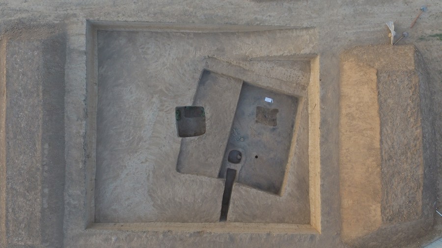
This aerial photo shows a house foundation that covers around 30 square meters unearthed at an archaeological site in Xinghuacun Township in Fenyang City, north China’s Shanxi Province.
The house foundations were found at an archaeological site in Xinghuacun Township in Fenyang City and traced back to the middle period of the Yangshao culture, according to the provincial institute of cultural relics and archaeology.
The Yangshao culture, dating back 5,000 to 7,000 years, was a Neolithic culture that originated along the middle reaches of the Yellow River.
The two house foundations, both halfway underground, were found in varying sizes. The larger site covers about 39 square meters, and the smaller one covers around 30 square meters.
Fragments of various artifacts, including millstone, sharp-bottomed bottles, and painted pottery pots, were unearthed at the larger site. In addition, the smaller site shows signs of burning.
“The discovery of two house foundations is of great significance to the study of the structure, layout, construction technology, and function of houses in the middle period of the Yangshao culture,” said Wang Pujun, the director of the archaeological project.
Genomic study of ancient humans sheds light on human evolution on the Tibetan Plateau
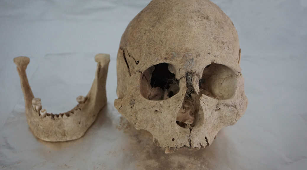
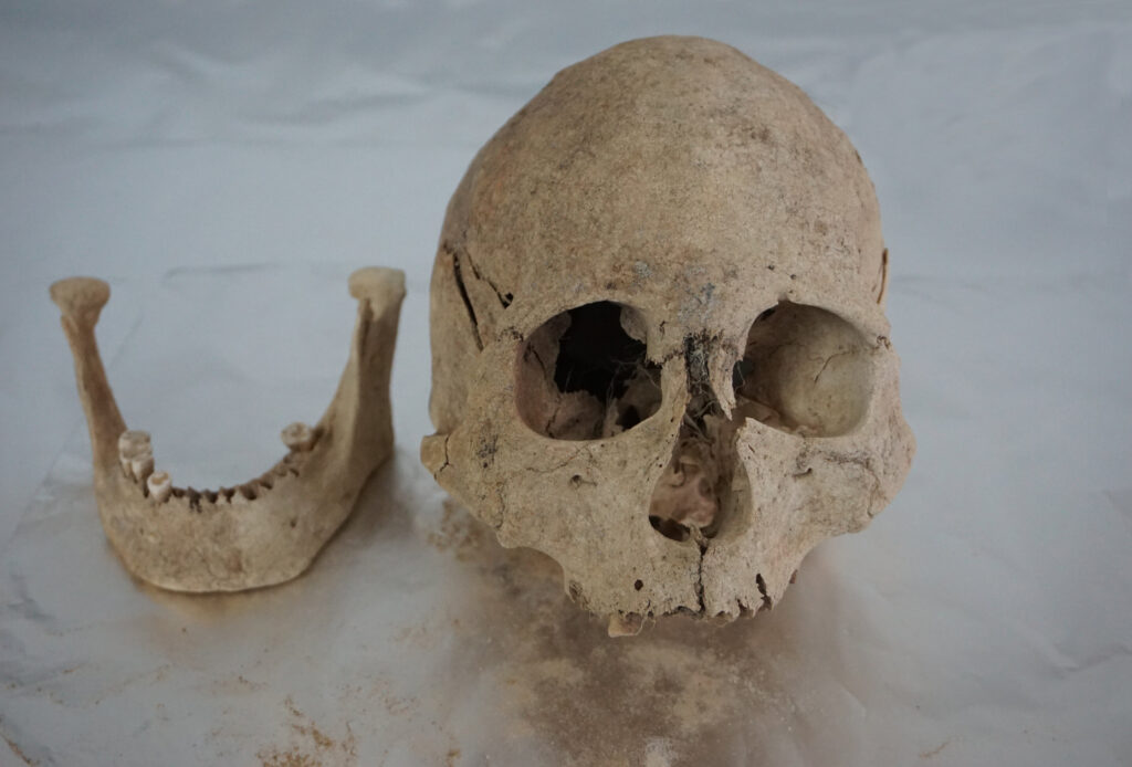
Cranium and mandible of an individual from Zongri (5213-3716 cal BP), an archaeological site from the Gonghe Basin in Qinghai, in the northeastern region of the Tibetan Plateau.
The Tibetan Plateau, the highest and largest plateau above sea level, is one of the harshest environments settled by humans. It has a cold and arid environment and its elevation often surpasses 4000 meters above sea level (masl).
The plateau covers a wide expanse of Asia—approximately 2.5 million square kilometers—and is home to over 7 million people, primarily belonging to the Tibetan and Sherpa ethnic groups.
However, our understanding of their origins and history on the plateau is patchy. Despite a rich archaeological context spanning the plateau, sampling of DNA from ancient humans has been limited to a thin slice of the southwestern plateau in the Himalayas.
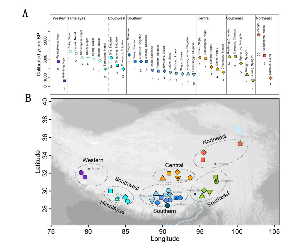
Now, a study published in Science Advances led by Prof. Fu Qiaomei from the Institute of Vertebrate Paleontology and Paleoanthropology (IVPP) of the Chinese Academy of Sciences has filled this gap by sequencing the genomes of 89 ancient humans dating back to 5100 BP from 29 archaeological sites spanning the Tibetan Plateau.
The researchers found that ancient humans living across the plateau share a single origin, deriving from a northern East Asian population that admixed with a deeply diverged, yet unsampled, human population.
“This pattern is found in populations since 5100 years ago, prior to the arrival of domesticated crops on the plateau,” said Prof. Fu. She noted that the introduction of northern East Asian ancestry to plateau populations occurred before barley and wheat were introduced and was not associated with migrating wheat/barley agriculturalists.
Chronological and geographic distribution of ancient individuals sampled from the Tibetan Plateau for this study.
A deeper comparison across the plateau reveals distinct genetic patterns prior to 2500 BP, indicating that three very different Tibetan populations occupied the northeastern, southern/central, and southern/southwestern regions of the plateau, with previously sampled plateau populations belonging only to the latter group.
Different population dynamics can be observed in these three regions. Northeastern populations younger than 4700 BP show an influx of additional northern East Asian ancestry in lower elevation regions (~3000 masl) such as the Gonghe Basin. However, this influx is not observed in higher elevation populations (~4000 masl) dating to 2800 BP just 500 km away.
An extended network of humans also lived along the Yarlung Tsangpo River, with a shared ancestry found in southern/southwestern populations dating to 3400 BP, western populations from Ngari Prefecture dating to 2300 BP, and southeastern populations from Nyingchi Prefecture dating to 2000 BP. The extended impact of these populations shows the important role this river valley played in Tibetan history.
“Between these two groups, central populations prior to 2500 BP share ancestry that differed from those further north and south. However, sampling of central populations after 1600 BP show that they share a closer genetic relationship to southern/southwestern populations. These patterns capture a dynamism in human populations on the plateau,” said Melinda Yang, assistant professor at the University of Richmond and a previous postdoc at IVPP.
“While ancient plateau populations show primarily East Asian ancestry, Central Asian influences can be found in some ancient plateau populations,” said Wang Hongru, professor at the Agricultural Genomics Institute in Shenzhen and a previous postdoc at IVPP. “Western populations show partial Central Asian ancestry as early as 2300 BP, and an individual dating to 1500 BP from the southwestern plateau additionally shows ancestry associated with Central Asian populations.”
Excavation in a branch cave in the upper chamber of Sding Chung, an archaeological site from the Shigatse Prefecture of Xizang, in the southwestern region of the Tibetan Plateau.
Present-day Tibetans and Sherpas show heavy influence from lowland East Asian populations, with differing levels of gene flow correlating with longitude. This pattern is not observed across populations of older time transects, including those dating from 1200–800 BP, indicating that lowland East Asian gene flow was largely a product of very recent human migration.
Previous research has shown that present-day plateau populations possess high frequencies of an endothelial Pas domain protein 1 (EPAS1) variant that is adaptive for living at high altitudes and likely originated from a past admixture event with the archaic humans known as Denisovans.
“Humans from this study show archaic ancestry typical of lowland East Asians, but the oldest individual dating to 5100 BP is homozygous for the adaptive variant,” said Prof. Fu. “Thus, the arrival of this variant occurred prior to 5100 BP in the ancestral population that contributed to all plateau populations.”
Through their broad spatiotemporal survey of ancient human DNA from the Tibetan Plateau, Prof. Fu and her team have revealed a Tibetan lineage that dates back to at least 5100 years ago on the Tibetan Plateau. The ancestral population diversified rapidly, such that three regional groups show unique historical patterns that began to merge after 2500 BP.
“This is the largest study of ancient genetics on the Tibetan Plateau to date,” said Lu Hongliang, a professor at Sichuan University. The new evidence in this study on the formation of unique components in the ancient populations from the Qinghai-Tibet Plateau is highly reliant on collaboration between multiple archaeological teams and geneticists. Prof. Lu notes that “Analyzing ancient DNA allows us to go beyond the study of cultural interaction using only archaeological evidence, and to put forward new ideas for archaeological research on the plateau.”
Future sampling is still needed, as the origin of the unsampled, deeply diverged ancestry found in all plateau populations is still unaccounted for. In addition, when and where the adaptive EPAS1 allele first entered the ancestral Tibetan population is still unknown.
But this study is a step in the right direction. “These genomes reveal a deep and diversified history of humans on the plateau,” said Prof. Fu. “With these findings, we have a much better understanding of an important part of human history in Asia.”
Innovative Construction Technique Spotted in Notre Dame
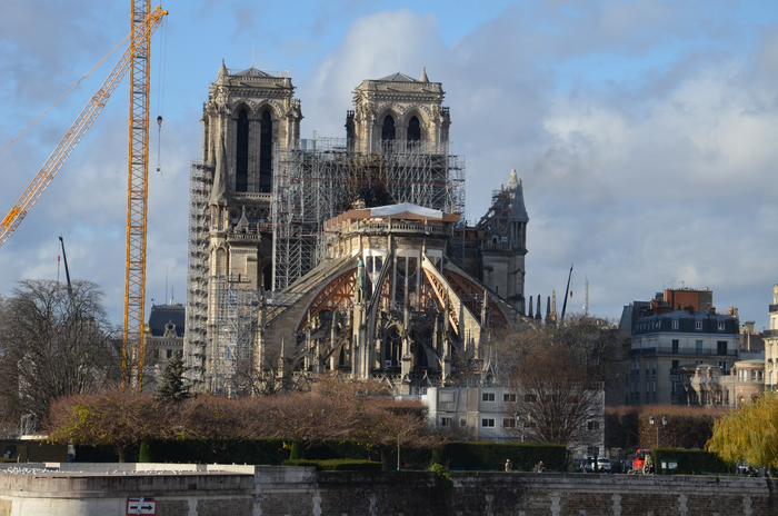
Notre Dame Cathedral before it underwent a massive reconstruction due to a fire.
In 2019, a fire broke out inside Notre Dame Cathedral in Paris, severely damaging the iconic medieval building. However, the catastrophic fire gave researchers an opportunity to study the building’s architecture like never before.
A few months after the inferno was extinguished, researchers discovered that the stones used to build the Gothic-style cathedral were held together using iron staples, a technique that had never been documented before in a building from this time period, according to a study published March 15 in the journal PLOS One.
Notre Dame was constructed in multiple phases starting in the early 12th century and continuing for the next 300 years, according to the Notre Dame Cathedral website.
“This is the first building of its kind in which we see this,” lead author Maxime L’Héritier, a professor in the Department of History at Paris 8 University, told Live Science. “This shows [that the builders] at the time were trying to experiment with new forms of construction.”
L’Héritier and his team analyzed 12 of the iron staples, which measure approximately 20 inches (50 centimeters) long and were part of the “iron skeleton” holding the building together, L’Héritier wrote in an essay for the archaeology publication Sapiens.
The staples offered additional reinforcements to the cathedral’s stonework, including holding together the large arches in the nave of the building’s towering 226-foot-tall (69 meters) twin towers.
Without the staples’ support, this architectural feat would likely have been impossible to accomplish in 1160, when construction of the building began, according to the study.
“When we studied other Gothic churches of that time period, none used iron in their construction,” L’Héritier said. “We believe that the staples were what enabled them to build this structure at such a terrific height.”
Researchers radiocarbon dated the iron staples and discovered that they were used during one of the initial construction phases, “confirming that the production date of the staples was the same as the masonry, which also dated to around 1160,” L’Héritier said.
However, L’Héritier cautioned that it will take further analysis to know the iron’s exact origins.
“We’re trying to figure out if it’s local or more distant,” L’Héritier said. “There also seems to be different ore sources depending on whether the construction occurred in the 12th or 13th centuries. We do know that the [cathedral’s] bishop died at the end of the 12th century, so it’s possible that a new ore resource was used years later. We should know more in a year or two.”
In the four years following the blaze, Notre Dame has been undergoing reconstruction and is expected to reopen to visitors in December 2024, according to AP News.
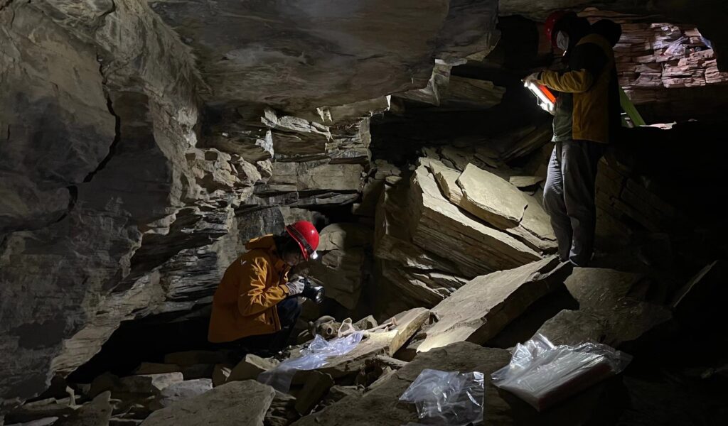
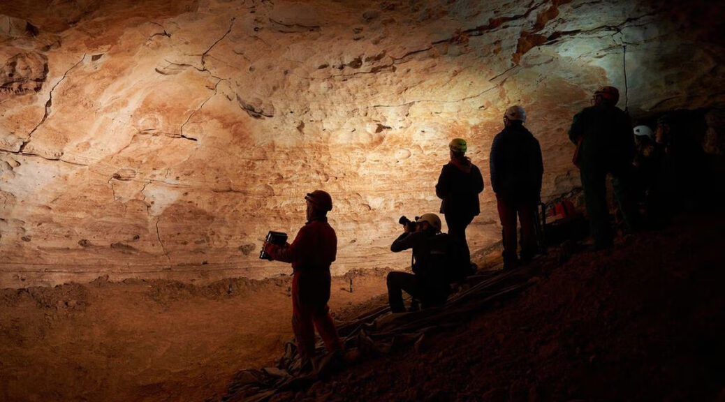
Prehistoric “Engravings Room” Rediscovered in Spain
Researchers from the Catalan Institute of Human Paleoecology and Social Evolution (IPHES) in front of the prehistoric cave paintings of Cova de la Vila.
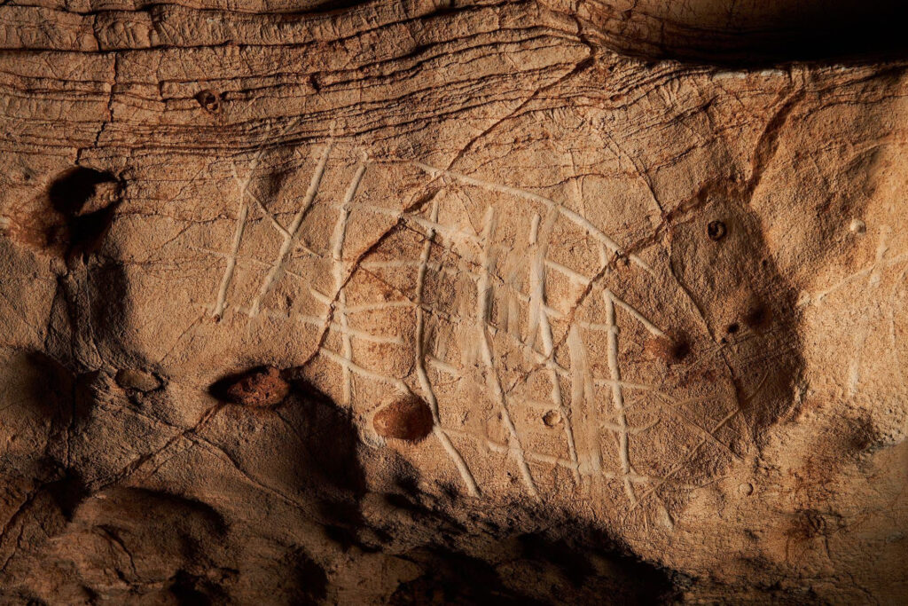
More than 100 prehistoric engravings have been discovered, arranged on an eight-meter panel, inside the cave known as Cova de la Vila, in La Febró (Tarragona), in Spain’s northeastern region of Catalonia.
The depictions found in the Mediterranean underground gallery have been described as “exceptional, both for their singularity and for their excellent state of conservation” by a team from the Catalan Institute of Human Paleoecology and Social Evolution (IPHES).
According to IPHES specialist Ramón Viñas, this mural represents the world view of first farmer societies during the Chalcolithic-Bronze age.
The engravings were first discovered on May 13, 2021 by a group of three cave explorers and subsequently underwent analysis by archaeologists and paleontologists from IPHES, the institute said in a statement.
Among the cave art samples, there are representations of different figures of quadrupeds, zigzags, linear, angular and circular lines, and a series of zoomorphs (possibly bovids and equines), star shapes and reticular lines.
The discovery of the cave art constitutes “one of the few representations of underground schematic art in the entire Mediterranean Arc,” said the regional government of Catalonia.
The discovery marks “a historic milestone for prehistoric archaeology,” according to IPHES.
The cave had been explored by Salvador Vilaseca in the 1940s, but its location had been lost. IPHES researchers managed to open a small hole between blocks of stone and came into an oval room of more than 90 square meters.
The first person to enter was Juli Serrano, who, to his surprise, saw a “mural full of lines and figures.” He says that when he came into the large, circular cavity and saw what it contained, he felt “a very great emotion, which I will take with me for life.” Without knowing it, he had just discovered one of the most important assemblages of prehistoric cave art. From that moment on, researchers Ramon Viñas and Josep Vallverdú from IPHES got to work on the site.
Viñas underscored how the panel of engravings is structured along five horizontal lines, one on top of the other, and how each of them contains different engraved figures that have their own meaning and symbolism.
The scientist points out that it is an “absolutely unusual” composition that indicates “a worldview on the part of the populations of the territory during the neolithization process.”
The prehistoric engravings in the underground complex of Cova de la Vila.
One of the singularities is that this cave art was made “exclusively with the engraving technique,” using a stone or wooden tool or directly with the fingers, explained Viñas.
The researcher considers that this, as well as the fact that it is “stylistically very homogeneous,” indicates a symbolic meaning. It is not a composition that is the result of chance.
During the transition period between the Chalcolithic and the Bronze Age, between the late 5th and the late 3rd millennia BC, human groups were generally found outdoors, their presence being very scarce in the underground cavities of Catalonia, in the northeast of the Iberian peninsula. Elsewhere in Spain, instances of underground dwellings have also been found in Andalusia, Segovia, Burgos, and Soria.
To guarantee its conservation, the regional government has closed access to Sala dels Gravats (Engravings Room). The site has been designated a cultural asset of national interest and work is underway to create a 3D model of the cave.
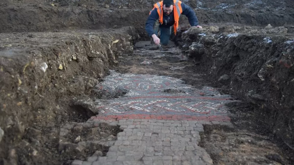
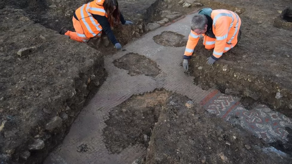
Roman villa mosaic found under Aldi supermarket site
The “intricate” mosaic was found at the site of a new Aldi supermarket in the town near Milton Keynes
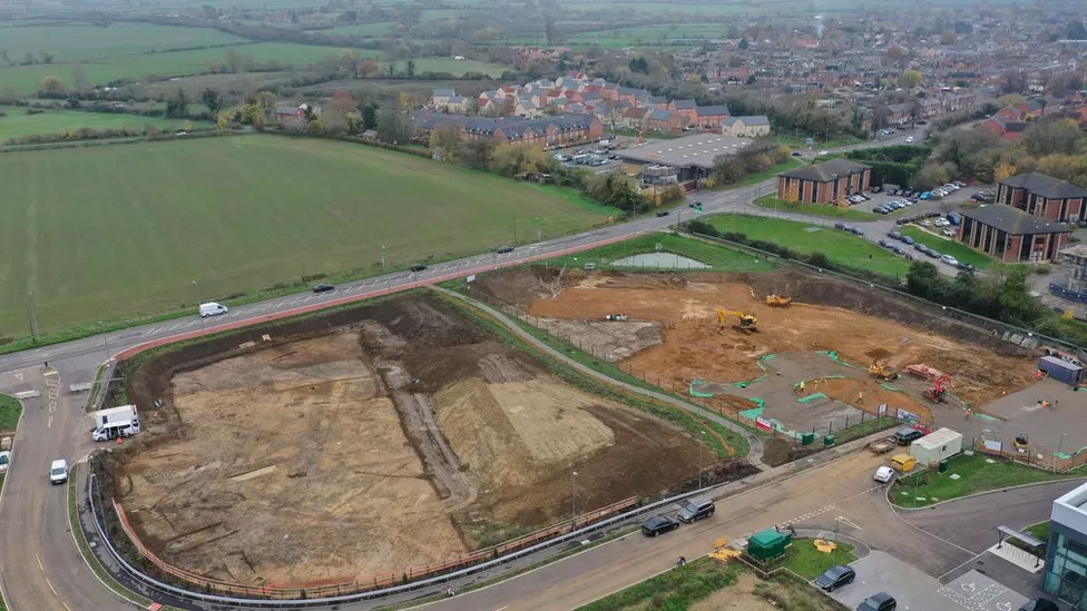
Archaeologists have uncovered what they believe are the remains of a Roman villa and bath house under land earmarked for a supermarket.
The discovery, which features mosaic brickwork, was made in Warrington Road in Olney, Buckinghamshire.
The site is being prepared for the construction of a new Aldi supermarket.
Oxford Archaeology, who carried out the work for developer Angle Property, deemed the mosaic “archaeological remains of high significance”.
The dig was commissioned due to the site’s proximity to the existing Roman Site at Olney.
Archaeologists said the mosaic featured “vibrant colours and intricate decorative patterns” made up of red, white and blue tiles.
The roman villa with a “vibrant” mosaic was deemed of “high significance”
Much of the ancient artworks were believed to extend under Warrington Road so could not be fully investigated, the digl team said.
Oxford Archaeology said that following consultations with Historic England and Milton Keynes Council, the mosaic has been preserved in situ.
It means materials have been placed over the brickwork to protect it, to allow construction to continue without causing damage.
John Boothroyd, senior project manager at Oxford Archaeology, said: “Due to the site location we anticipated some notable Roman remains, but the discovery of this fantastic mosaic far exceeded those expectations.
“To be able to preserve remains of this quality and importance is a brilliant outcome, and one that could only have been achieved with the support of Angle Property.”
Anthony Williamson, executive director of Angle, said the find had “taken us all by surprise” and promised it “will be fully recorded” and information about it published.
The site was excavated due to its proximity to an existing Roman settlement monument
6,000-Year-Old Settlement Was home to Europe’s first megalithic monument makers
Archaeologists in France unearthed the remains of a series of wooden buildings within a defensive enclosure that were built at the same time as the first stone monuments were being erected.
People in west-central France built a variety of megalithic monuments during the Neolithic period, including mound-like barrows and “dolmens” — a type of single-chamber tomb supported by two or more upright megaliths. While these stone monuments are visible and have withstood the test of time, traces of their homes have been more difficult to find — until now.
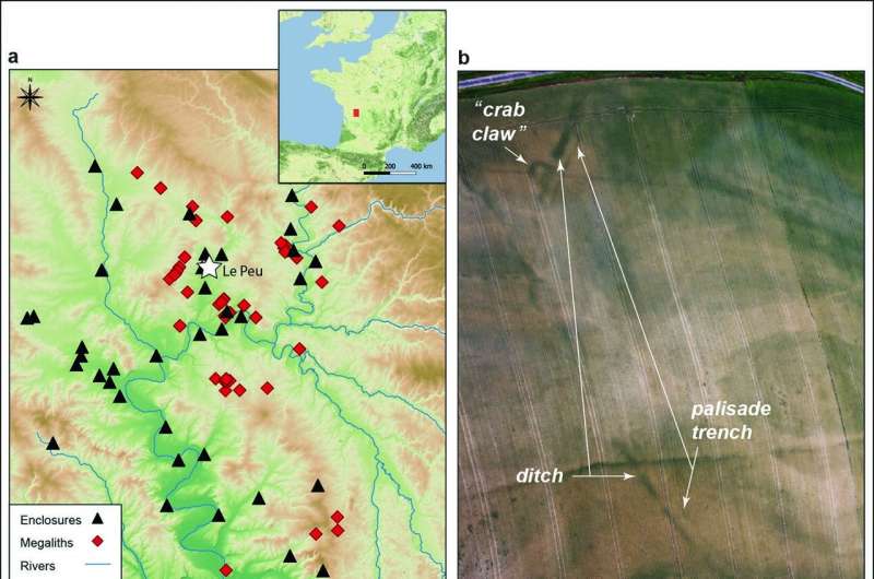
Now, Dr. Vincent Ard from the French National Center for Scientific Research. and a team of researchers working in the Charente department has identified the first known residential site belonging to some of Europe’s first megalithic builders.
“It has been known for a long time that the oldest European megaliths appeared on the Atlantic coast, but the habitats of their builders remained unknown,” said Dr. Vincent Ard.
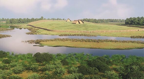
Since it was first found during an aerial survey back in 2011, the enclosure at Le Peu, in the commune of Charmé, has been the focus of an intense investigation.
The results of this work, published in the journal Antiquity, revealed a palisade encircling several timber buildings built during the fifth millennium BC.
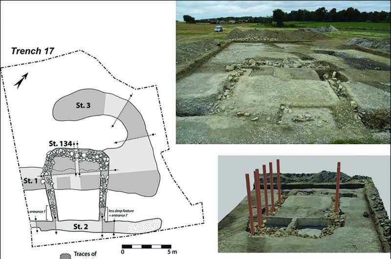
This makes them the oldest wooden structures in the region and the first residential site contemporary with the Neolithic monument makers. At least three homes were found, each around 13 meters long, clustered together near the top of a small hill enclosed by the palisade.
The structures at Le Peu, the researchers said, represent both the oldest-known wooden structures in the region as well as the first known residential site that existed at the same time that the Neolithic monuments were being built.
To test this, the archaeologists carried out radiocarbon dating that revealed these monuments are contemporary with Le Peu, suggesting the two sites are linked.
While the people of Le Peu may have built monuments to the dead, they also invested a lot of time and effort in protecting the living. Analysis of the paleosol recovered from the site revealed it was located on a promontory bordered by a marsh. These natural defenses were enhanced by a ditch palisade wall that extended around the site.
The entrance had particularly heavy defenses, guarded by two monumental structures. These appear to have been later additions, requiring part of the defensive ditch to be filled in.
“The site reveals the existence of unique monumental architectures, probably defensive. This demonstrates a rise in Neolithic social tensions,” said Dr. Ard.
However, these impressive defenses may have proved insufficient as all the buildings at Le Peu appear to have been burnt down around 4400 BC. However, such destruction helped preserve the site.
As a result, Dr. Ard and the team are hopeful that future studies at Le Peu will continue to provide insight into the lives of people whose only known contributions to human history are memorials. Already, it demonstrates the monumental scale of their residential sites, which was unprecedented in prehistoric Atlantic society.
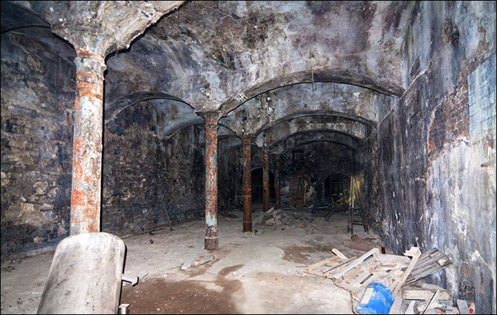
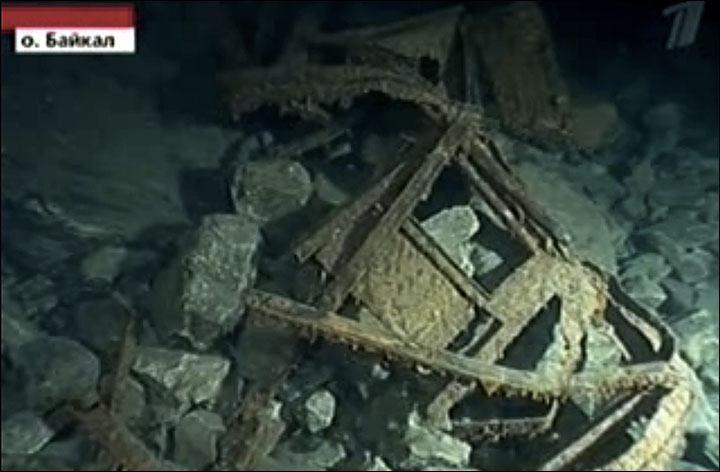
A secret stash of tsar’s gold worth billions was found in an old rail tunnel near Lake Baikal
Royal discovery made after 99-year-old code is broken by Siberian mathematics genius.
A formal statement is due around noon in Moscow on Saturday when the first pictures of the gold will be revealed to the world’s media.
The former tunnel and at an undisclosed location in the Irkutsk region is today under the protection of the Russian national guard after the sensational discovery exactly a century after Tsar Nicholas II was deposed.
Rail carriages packed with gold bullion bearing the Romanov insignia along with ‘other treasures’ – in the possession of anti-Bolshevik forces as they retreated from the Red Army after the Russian Revolution – were hidden in 1918, according to sources quoted by multiple Russian news agencies.
At least one ‘crown once worn by the last Russian emperor’ is in the collection, it was reported early today.
Unlike last year’s claim of Nazi gold hidden in Poland, today’s report is ‘genuine and verified by competent state organs’ under direct Kremlin orders, said a source close to the discovery.
A formal statement is due around noon in Moscow on Saturday when the first pictures of the gold will be revealed to the world’s media.
The former tunnel and at undisclosed location in Irkustk region is under the protection of the Russian national guard.
The first consignments will be moved to the Russian Central Bank within hours. The treasure has been claimed already by the Russian state in a closed-door court case beginning at 00.01 on Saturday in Irkutsk under tight security.
The stash ‘more than compensates for the cost of sanctions imposed by Western governments’, said an informed insider early today.
The location of the gold was discovered after a secret code giving the coordinates of the location in the Irkutsk region – originally found deep in the Stalin era – was cracked by a 21-year-old mathematics protege who studies in Tomsk.
The document was seized from a Kolchak aide in 1919 and has lain for years in a Russian national archive in Moscow.
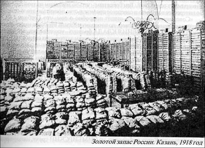
Russia’s gold pictured in vaults of Kazan State Bank in 1918.
Over the decades, experts have failed to understand the bizarre instructions written in Russian, French, and English.
‘It was simple once I understood the importance of the numbers 1 and 4 and their complex interrelationship,’ said the student in an interview with TASS news agency.
The mathematics genius, who has not been named because he is also a ‘hacking maestro’ suspected by the FBI of involvement in penetrating Hillary Clinton’s emails, took less than one hour to crack the decades-old formula designed to inform royalists the location of the treasure.
Since the defeat of Admiral Alexander Kolchak, leader of the White Russian forces, there has been speculation about the tsar’s gold, and where it was stashed.
In the months leading up to July 1918, when abdicated ruler Nicholas II and his family were shot on Lenin’s orders, it is estimated that 73% of the world’s largest gold reserves were held in Kazan, a city on the Volga River, before most was shifted further east into Siberia.
It had been moved here for security reasons during the First World War.
Alexander Kolchak.
Grainy pictures from the vaults of a Kazan bank highlight that gold and other precious metals of untold value were held here. It is known that huge stocks of gold were removed to Omsk in Siberia by train on 13 October 1918.
One month later Kolchak was proclaimed Supreme Ruler of the country and Omsk was briefly the capital city of anti-Bolshevik Russia.
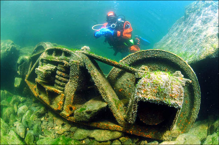
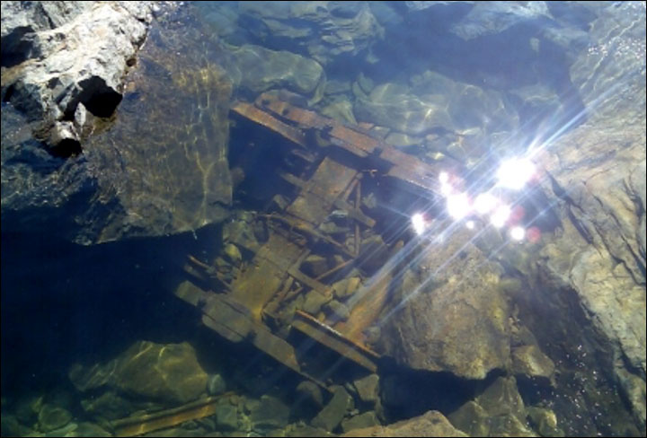
One theory is that as the gold was transported east from Omsk and some of the suspected 1,600 tons of royal bullion sank into Lake Baikal near Cape Polovinny after a train accident.
Mini-submarines scored Lake Baikal in 2010 for a cargo of gold that was reported to have fallen from a derailed train into the lake.
Separate claims suggested gold was carried towards Imperial China by troops loyal to Kolchak across frozen Baikal in the winter of 1919-20.
Other claims suggested gold was buried in the Krasnoyarsk region.
Mini-submarines scored Lake Baikal in 2010 for a cargo of gold that was reported to have fallen from a derailed train into the lake.
Mini-submarines scored Lake Baikal in 2010 for a cargo of gold that was reported to have fallen from a derailed train into the lake. Pictures: Channel 1 TV, The Siberian Times
In 1928, a New York court was told that the gold was elsewhere – buried in woods near Kazan.
There have been claims the value of tsarist gold could be as much as $80 billion.
Provisional estimates from the site in the Irkutsk region suggest the stash is worth a little less than $30 billion.
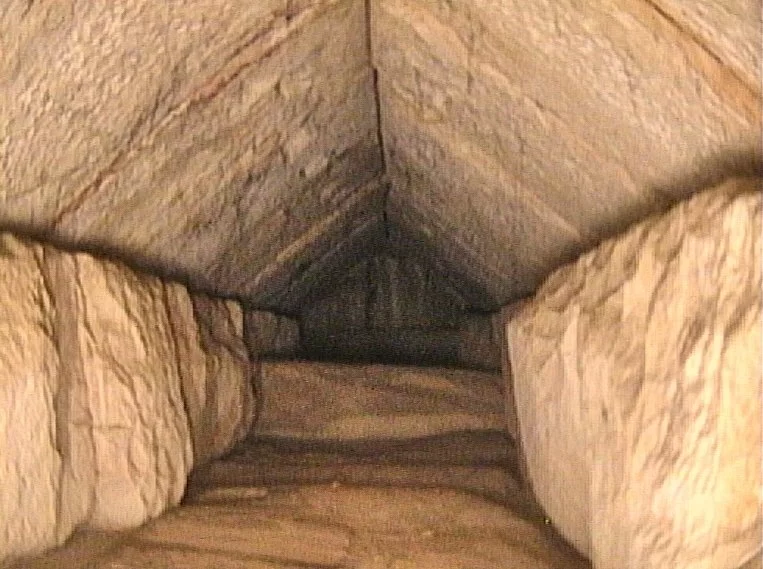
Scientists reveal new discovery inside the Pyramid of Khufu
An Egyptian pyramid for 4,500 years is still spilling secrets. After a years-long project using modern technology to reveal the secrets inside the last of the Seven Wonders of the Ancient World that is still standing, a once-hidden corridor inside the Great Pyramid of Khufu (Great Pyramid of Giza) has been identified.
An international research team used a cosmic ray imaging method to analyze a cavity discovered behind the pyramid’s north face in 2016. Their findings were announced at a news conference with Egyptian officials.
“This discovery, in my opinion, is the most important discovery of the 21st Century,” Zahi Hawass, Egypt’s former minister of antiquities, told reporters outside the pyramid.
The corridor – on the northern side of the Pyramid of Khufu – was discovered using modern scanning technology.
It measures 9 meters (nearly 30 feet) in length and is 2 meters (over 6 feet) wide, perched above the main entrance of the pyramid.
Archaeologists have not yet ascertained the function of the chamber, which is not accessible from the outside. In 2017, scientists announced the discovery of another sealed-off corridor, a 30-meter chamber – or about 98 feet – also inside the Pyramid of Khufu.
The corridor, officials said, adding that it was most likely designed to help relieve the weight of the vast structure, which was built as royal burial chambers around 2560 B.C.
A hidden corridor inside the Great Pyramid of Giza that was discovered by researches recently, in Giza, Egypt.
The pyramid, also known as Khufu’s Pyramid, was built by Khufu, a 4th Dynasty pharaoh who ruled from 2509 to 2483 B.C., on the Giza plateau outside of Cairo.
“The discovery today tells us there is something important to be discovered soon under that tunnel, which could be the real burial chamber of Khufu,” Hawass said.
The most recent find is a part of the global “ScanPyramids” project, which was initiated by Egypt’s antiquities ministry in October 2015 and aims to peer inside the enormous structures without using invasive drilling techniques.
Since there is disagreement among experts regarding how the pyramids were built, even relatively small discoveries are of great interest. To increase tourism, a key source of foreign currency for the cash-strapped Middle Eastern nation, authorities frequently publicly tout discoveries.