Study Investigates Rate of Parasite Infections in a Medieval City
Research examining traces of parasites in the remains of medieval Cambridge residents suggests that local friars were almost twice as likely as ordinary working townspeople to have intestinal worms – despite monasteries of the period having far more sanitary facilities.
One possibility is that the friars manured their vegetable gardens with human faeces
Piers Mitchell
A new analysis of remains from medieval Cambridge shows that local Augustinian friars were almost twice as likely as the city’s general population to be infected by intestinal parasites.
This is despite most Augustinian monasteries of the period having latrine blocks and hand-washing facilities, unlike the houses of ordinary working people.
Researchers from the University of Cambridge’s Department of Archaeology say the difference in parasitic infection may be down to monks manuring crops in friary gardens with their own faeces, or purchasing fertiliser containing human or pig excrement.
The study, published today in the International Journal of Paleopathology, is the first to compare parasite prevalence in people from the same medieval community who were living different lifestyles, and so might have differed in their infection risk.
The population of medieval Cambridge consisted of residents of monasteries, friaries and nunneries of various major Christian orders, along with merchants, traders, craftsmen, labourers, farmers, and staff and students at the early university.
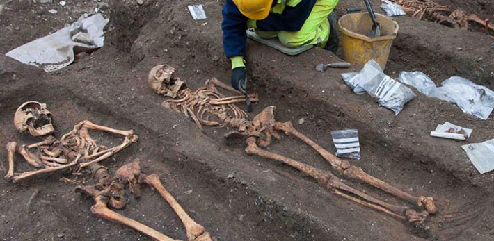
Cambridge archaeologists investigated samples of soil taken from around the pelvises of adult remains from the former cemetery of All Saints by the Castle parish church, as well as from the grounds where the city’s Augustinian Friary once stood.
Most of the parish church burials date from the 12-14th century, and those interred within were primarily of lower socioeconomic status, mainly agricultural workers.
The Augustinian friary in Cambridge was an international study house, known as a studium generale, where clergy from across Britain and Europe would come to read manuscripts. It was founded in the 1280s and lasted until 1538 before suffering the fate of most English monasteries: closed or destroyed as part of Henry VIII’s break with the Roman Church.
The researchers tested 19 monks from the friary grounds and 25 locals from All Saints cemetery and found that 11 of the friars (58%) were infected by worms, compared with just eight of the general townspeople (32%).
They say these rates are likely the minimum, and that actual numbers of infections would have been higher, but some traces of worm eggs in the pelvic sediment would have been destroyed over time by fungi and insects.
The 32% prevalence of parasites among townspeople is in line with studies of medieval burials in other European countries, suggesting this is not particularly low – but rather the infection rates in the monastery were remarkably high.
“The friars of medieval Cambridge appear to have been riddled with parasites,” said study lead author Dr Piers Mitchell from Cambridge’s Department of Archaeology. “This is the first time anyone has attempted to work out how common parasites were in people following different lifestyles in the same medieval town.”
Cambridge researcher Tianyi Wang, who did the microscopy to spot the parasite eggs, said: “Roundworm was the most common infection, but we found evidence for whipworm infection as well. These are both spread by poor sanitation.”
Standard sanitation in medieval towns relied on the cesspit toilet: holes in the ground used for faeces and household waste. In monasteries, however, running water systems were a common feature – including rinsing out the latrine – although that has yet to be confirmed at the Cambridge site, which is only partly excavated.
Not all people buried in Augustinian friaries were actually clergy, as wealthy people from the town could pay to be interred there. However, the team could tell which graves belonged to friars from the remains of their clothing.
“The friars were buried wearing the belts they wore as standard clothing of the order, and we could see the metal buckles at excavation,” said Craig Cessford of the Cambridge Archaeological Unit.
As roundworm and whipworm are spread by poor sanitation, researchers argue that the difference in infection rates between the friars and the general population must have been due to how each group dealt with their human waste.
“One possibility is that the friars manured their vegetable gardens with human faeces, not unusual in the medieval period, and this may have led to repeated infection with the worms,” said Mitchell.
Medieval records reveal how Cambridge residents may have understood parasites such as roundworm and whipworm. John Stockton, a medical practitioner in Cambridge who died in 1361, left a manuscript to Peterhouse college that included a section on De Lumbricis (‘on worms’).
It notes that intestinal worms are generated by an excess of various kinds of mucus: “Long roundworms form from an excess of salt phlegm, short roundworms from sour phlegm, while short and broad worms came from natural or sweet phlegm.”
The text prescribes “bitter medicinal plants” such as aloe and wormwood, but recommends they are disguised with “honey or other sweet things” to help the medicine go down.
Another text – Tabula medicine – found favour with leading Cambridge doctors of the 15th century, and suggests remedies as recommended by individual Franciscan monks, such as Symon Welles, who advocated mixing a powder made from moles into a curative drink.
Overall, those buried in medieval England’s monasteries had lived longer than those in parish cemeteries, according to previous research, perhaps due to a more nourishing diet, and a luxury of wealth.