8,000 years old Stone Tools Found on Iran’s Gav-Bast Mountain
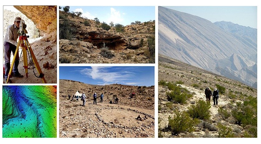
Archaeologists have found arrays of stone tools and relics on top of Gav-Bast Mountain, which is situated in southern Iran, north of the Persian Gulf.
Fereidoun Biglari, an archaeologist and cultural deputy of the National Museum of Iran, briefed attendees on the discovery during the 19th Annual Symposium on the Iranian Archaeology held in Tehran.
Gav-Bast Mountain is of great importance in Iranian rock art archaeology due to the existence of a prehistoric rock shelter that contains a hunting scene including archers, animal games, and a large carnivore.
In his lecture, Biglari first reviewed the history of archaeological research in Eshkat-e Ahou Rockshelter, which began with Khaled Sadeghi’s efforts in 2001 that later led to the registration of this prehistoric site in the National Monuments List in 2005 by the General Directorate of Cultural Heritage of Hormozgan.
Regarding his motivation for starting a new study in Gav-Bast Mountain, Biglari said that the focus of previous studies was more on the rock art panel in the shelter itself and the surrounding areas have not been surveyed by archaeologists.
As a result of several short field surveys in 2010 and 2021, which were carried out with the support of the municipality and Bastak Charity Association and the permission of the Iranian Center for Archaeological Research and the General Directorate of Hormozgan Cultural Heritage, new information about prehistoric settlements on these mountain highlands was obtained.
He added that this research proved that Neolithic human groups used natural resources of these highlands- between 1,100 and 1,800 meters above sea level – probably on a seasonal basis about 7,000 – 8,000 years before present.

The researcher also spoke about the importance of preservation of the prehistoric motifs of Gav-Bast and the measures taken to document the art and its context, including drone mapping, 3D model of the shelter, and its panel using photogrammetry, and other related measures.
In conclusion, Biglari expressed hope that in the near future, the detailed 3D model of the shelter and its paintings will be displayed in the Bastak Museum and the National Museum of Iran would allow visitors to see this remote site and its painting panel in the museum.
Furthermore, he emphasized that this research would not have been possible without the help and support of the Bastak Municipality and Charity Association.
Gav-Bast Mountain is lined with the Zagros Mountains, extending northwest-southeast from the border areas of eastern Turkey and northern Iraq to the Strait of Hormuz. The Zagros range is about 1,600 km long and more than 240 km wide.
Situated mostly in what is now Iran, it forms the extreme western boundary of the Iranian plateau, though its foothills to the north and west extend into adjacent countries.
The first well-documented evidence of human habitation is in deposits from several excavated cave and rock-shelter sites, located mainly in the Zagros Mountains of western Iran and dated to Middle Paleolithic or Mousterian times (c. 100,000 BC).
From the Caspian in the northwest to Baluchistan in the south-east, the Iranian Plateau extends for close to 2,000 km. It encompasses the greater part of Iran, Afghanistan, and Pakistan west of the Indus River containing some 3,700,000 square kilometres.
Despite being called a “plateau”, it is far from flat but contains several mountain ranges, the highest peak being Damavand in the Alborz mountain range at 5610 m, and the Dasht-e Loot east of Kerman in Central Iran falling below 300 m.