Ancient Helmets and Temple Ruins Exhumed Where Greeks Settlers First Arrived in Italy
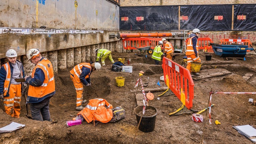
Archaeologists in southern Italy have discovered ancient warrior helmets and the ruins of a painted brick wall at a site that might have been a forerunner of a temple dedicated to the goddess Athena, officials said Tuesday.
Remains of an ancient helmet found in southern Italy.
Italian Culture Minister Dario Franceschini said the remains dug up at the popular tourist site of Velia were found on what had been an acropolis of one of Magna Graecia’s most important cities.
Velia is 40 kilometres (25 miles) southeast of Paestum, a much-visited site of ancient Greek temples.
The recently completed excavation at Velia unearthed a pair of helmets in good condition, the remains of a building, vases with the Greek inscription for “sacred” and metal fragments of what possibly were weapons, the culture ministry said.
State Museums Director Massimo Osanna, who formerly had long directed excavations at Pompeii, Italy’s most celebrated excavated site, said the area explored at Velia probably contained relics of offerings made to Athena, the mythological Greek goddess of war and wisdom, after a key naval battle in the nearby Tyrrhenian Sea.
In the 6th-century B.C. battle of Alalia off the coast of Corsica, Greek forces were victorious over Etruscan forces and their Carthaginian allies.
Velia is famed for being the home of an ancient Greek school of philosophy, including philosophers Parmenides and Zeno.
It was part of Magna Graecia, the area of southern Italy colonized by Greek city-states.
The settlement at Velia occupied an upper part, or acropolis, of the area as well as hillsides, and was surrounded by a wall. The city’s ancient name was Elea.
Velia’s founding dates to about 540 B.C. by colonists from Asia Minor.
Franceschini said the discoveries yielded by the Velia excavation underscored the importance of investing in archaeological research to reveal “important pieces of the history of the Mediterranean.”
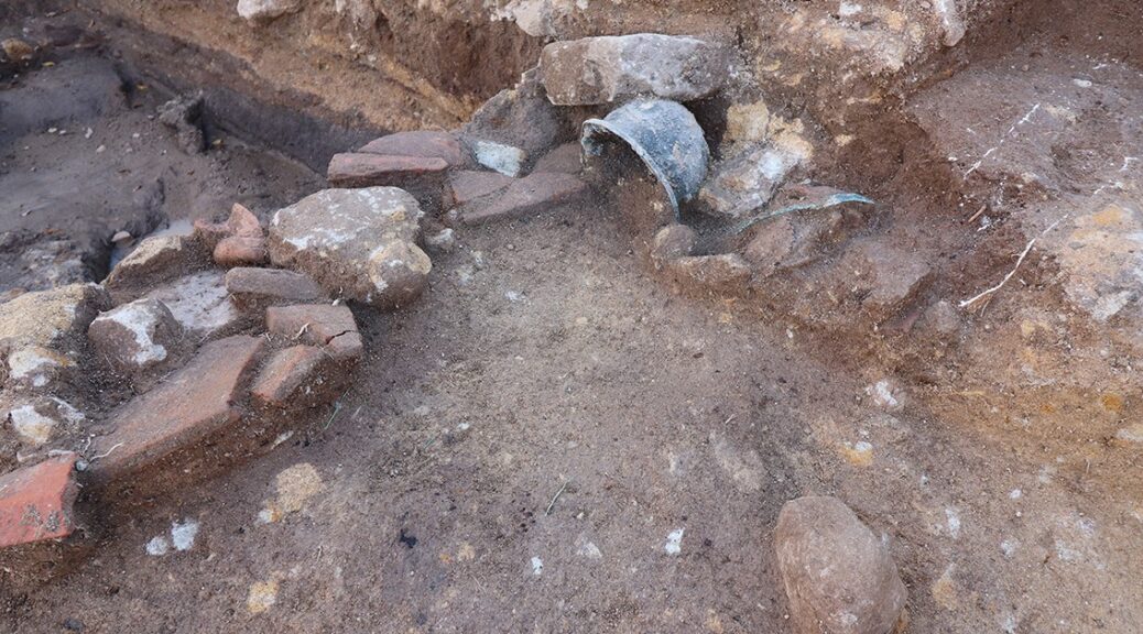
2000-year-old ‘lost’ street built by Pontius Pilate uncovered in Jerusalem
Archaeologists have unearthed part of a 2,000-year-old ‘lost’ street built by Pontius Pilate that likely served as a route for pilgrimage within the ancient city. The street had been buried when the Roman ransacked the city in 70 AD.
The ancient walkway linking the Temple Mount with the Pool of Siloam was first discovered in 1894 by British archaeologists in Jerusalem’s ‘City of David’.
Researchers have now found more than 100 coins beneath the paving stones that date the street to around the year 31 AD. The finding provides strong evidence that the street was commissioned by Pontius Pilate, the Roman governor of the province Judaea from 23–36 AD.
Pilate is best known as the biblical official who presided over the trial of Jesus and ordered his crucifixion.
The 722 feet (220 metres) -long section of the road was unearthed by researchers from the Israel Antiquities Authority and Tel Aviv University after six years of extensive archaeological excavations.
The ancient walkway linking the Temple Mount with the Pool of Siloam was first discovered in 1894 by British archaeologists in Jerusalem’s ‘City of David’
The walkway ascends from the Pool of Siloam in the south to the Temple Mount — both sites of significance to the followers of Judaism and Christianity
The walkway ascends from the Pool of Siloam in the south to the Temple Mount — both sites of significance to the followers of Judaism and Christianity. The Temple Mount, located within the Old City of Jerusalem, has been venerated as a holy site for thousands of years.
According to the bible, the Pool of Siloam was the location where Jesus performed the miracle of healing the man born blind, at around the same as the street was being constructed. During the dig, the team uncovered more than 100 coins trapped beneath the street’s paving stones.
The latest coins were dated between 17–31 AD — firm evidence that work began and was completed during the time that Pilate governed Judea.
‘Dating using coins is very exact,’ said paper author and archaeologist Donald Ariel, of the Israel Antiquities Authority.’
‘As some coins have the year in which they were minted on them, what that means is that if a coin with the date on it is found beneath the street, the street had to be built in the same year or after that coin had been minted, so any time after.’
‘However, our study goes further, because statistically, coins minted some 10 years later are the most common coins in Jerusalem.’
‘So not having them beneath the street means the street was built before their appearance, in other words only in the time of Pilate.’
Archaeologists have unearthed part of a 2,000-year-old ‘lost’ street, pictured, built by Pontius Pilate that likely served as a route for pilgrimage within the ancient city
During the dig, the team uncovered more than 100 coins trapped beneath the street’s paving stones. Pictured, US officials attending the opening of the ancient road
The ancient walkway linking the Temple Mount with the Pool of Siloam, pictured in this artist’s impression, was first discovered in 1894 by British archaeologists in Jerusalem’s ‘City of David’
According to the bible, the Pool of Siloam was the location where Jesus performed the miracle of healing the man born blind, at around the same as the street was being constructed
The street — which was 0.37 miles (600 metres) -long and around 26 feet (eight metres) wide — was paved with the large stone slabs that were customary across the Roman Empire. The researchers estimate that some 10,000 tons of quarried limestone rock would have been used in its construction — a feat requiring considerable skill.
The opulent and grand nature of the street, coupled with the fact that it links two of the most important spots in Jerusalem — Temple Mount and the Pool of Siloam — both provide strong evidence that the street acted as a route for pilgrims.
‘If this was a simple walkway connecting point A to point B, there would be no need to build such a grand street,’ said paper author and Israel Antiquities Authority archaeologist Joe Uziel.
‘At its minimum, it is eight metres wide. This, coupled with its finely carved stone and ornate “furnishings” like a stepped podium along the street, all indicate that this was a special street.’
Pilate is best known as the biblical official who presided over the trial of Jesus and ordered his crucifixion, as depicted in this painting
The street — which was 0.37 miles (600 metres) -long and around 26 feet (eight metres) wide — was paved with the large stone slabs that were customary across the Roman Empire
The paving stones of the street were found hidden beneath layers of rubble, which researchers believe was generated when Romans captured and destroyed the city in 70 AD
‘Part of it may have been to appease the residents of Jerusalem,’ added paper co-author and archaeologist Nahshon Szanton.
‘Part of it may have been about the way Jerusalem would fit in the Roman world, and part of it may have been to aggrandise [Pontius Pilate’s] name through major building projects.’
The paving stones of the street were found hidden beneath layers of rubble, which researchers believe was generated when Romans captured and destroyed the city in 70 AD.
This rubble contained weapons — including arrowheads and stones for slings — along with the remains of burnt trees and collapsed stones from the buildings along its edge. The researchers say that it is possible that Pilate had the street built in order to help reduce tensions with the Jewish population.
‘We can’t know for sure, although all these reasons do find support in the historical documents,’ added Dr Ariel. The full findings of the study were published in Tel Aviv: Journal of the Institute of Archaeology of Tel Aviv University.
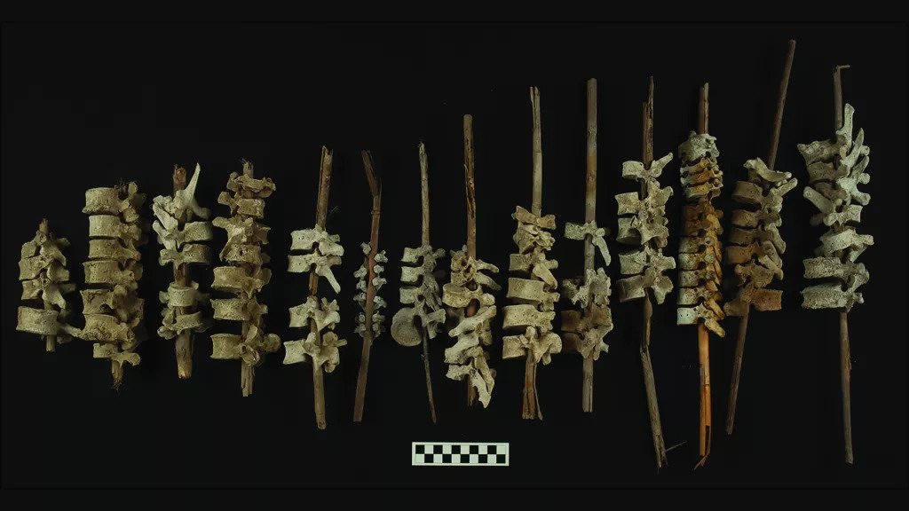
Human spines on sticks found in 500-year-old graves in Peru
Hundreds of years ago, Indigenous people in coastal Peru may have collected the scattered remains of their dead from desecrated graves and threaded reed posts through the spinal bones.
Examples of vertebrae on posts, found in Peru’s Chincha Valley.
Scientists recently counted nearly 200 of these bone-threaded posts in stone tombs in Peru’s Chincha Valley, and they suspect that the practice arose as a means of reassembling remains after the Spanish had looted and desecrated Indigenous graves.
Archaeologists investigated 664 graves in a 15-square-mile (40 square kilometres) zone that contained 44 mortuary sites. They documented 192 examples of posts threaded with vertebrae.
The researchers then measured the amount of radioactive carbon in the bones and reed posts. Radioactive carbon accumulates when an organism is alive but decays to nitrogen at a constant rate once the organism is dead. So based on the amount of this carbon, the scientists could estimate when the posts were assembled.
Their analysis placed the vertebrae and posts between A.D. 1450 and 1650 — a time when the Inca Empire was crumbling and European colonizers were consolidating power, the researchers wrote in a new study.
This was a period of upheaval and crisis in which Indigenous tombs were frequently desecrated by the Spanish, and Chincha people may have revisited looted tombs and threaded spinal bones on reeds in order to reconstruct disturbed burials, said lead study author Jacob Bongers, a senior research associate of archaeology with the Sainsbury Research Unit at the University of East Anglia in the United Kingdom.
“The fact that there’s 192 of these and that they’re widespread — we find these throughout the Chincha Valley — it means on one level that multiple groups of people coordinated and responded in a shared way, that this interesting practice was deemed the appropriate way of dealing with disturbed bodies of the dead,” Bongers told Live Science.
Most of the vertebrae on posts were found in and around large and elaborate stone tombs, called chullpas, that typically held multiple burials; in fact, one chullpa contained remains from hundreds of people, Bongers said.
In one of the chullpas, threaded vertebrae were inserted into a cranium.
The people who performed the burials were part of the Chincha Kingdom, “a wealthy, centralized society that dominated Chincha Valley during the Late Intermediate period, which is the period that precedes the Incan Empire,” Bongers explained.
The Chincha Kingdom once had a population numbering around 30,000, and it thrived from around A.D. 1000 to 1400, eventually merging with the Inca Empire toward the end of the 15th century. But after the Europeans arrived and brought famines and epidemics, Chincha numbers plummeted to just 979 heads of household in 1583, according to the study.
Historic documents record accounts of Spaniards frequently looting Chincha graves across the valley, stealing gold and valuable artefacts, and destroying or desecrating remains.
For the new study, the researchers closely examined 79 bone-threaded posts, each of which represented a collection of spinal bones from an adult or from a child.
Most posts held bones belonging to a single individual, but the spines were incomplete, with most of the bones disconnected and out of order. This suggested that the threading was not performed as a part of the original burial. Rather, someone gathered and threaded the spinal vertebrae after the bodies had decomposed — and perhaps after some of the bones were lost to looting, the study authors reported.
Two chullpas in the middle Chincha Valley.
And because Andean cultures valued preserving the integrity and completeness of a dead body, the likeliest explanation is that Chincha people revisited looted graves and reconstructed the scattered remains in this way to try and restore some semblance of wholeness to remains that had been dispersed and desecrated.
“When you look at all data we gathered, all of that supports the model that these were made after these tombs had been looted,” Bongers said.
Ancient mortuary practices, such as this bone threading, provide valuable clues about how long-ago communities dealt with their dead, but they also shed light on how people defined their identities and culture through their relationships with the dead, Bongers told Live Science.
“Mortuary practices arguably are what make us human — this is one of the key distinguishing features of our species. So, by documenting mortuary practices, we’re learning diverse ways of how people showcased their humanity.”
The findings were published on Feb. 2 in the journal Antiquity.
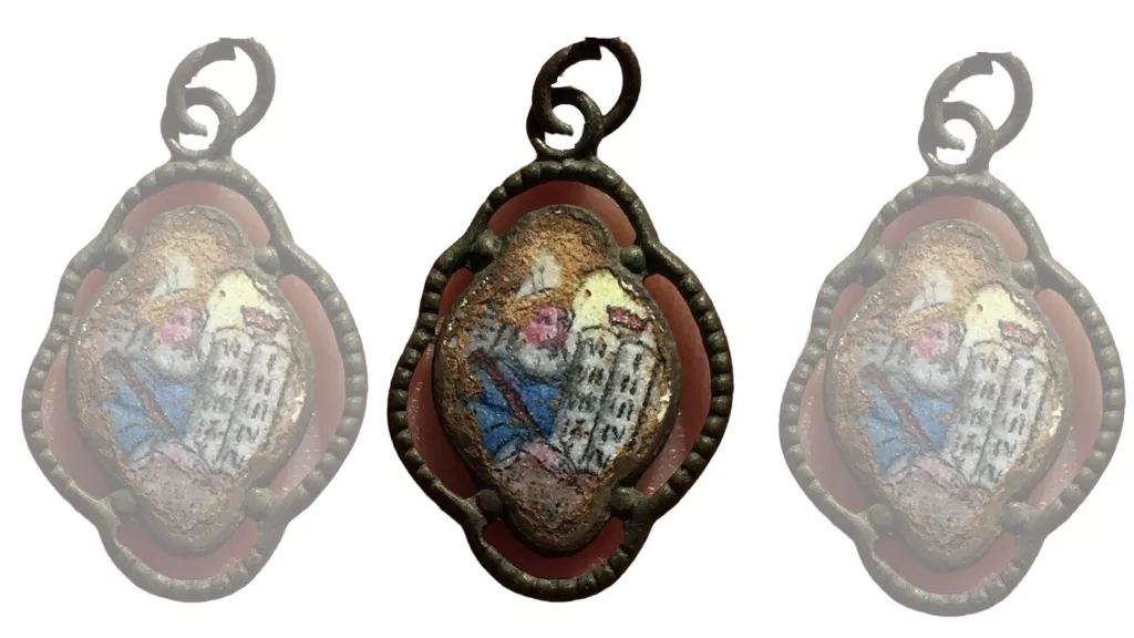
Archaeologists in Poland have discovered three pendants that belonged to people who were murdered at Sobibor, a Nazi death camp in eastern Poland.
A pendant featuring Moses holding the Ten Commandments was found by the gas chambers located in Camp II at Sobibor.
The researchers discovered two of the pendants in places where Holocaust victims were forced to undress before guards herded them into gas chambers; they discovered the third pendant near a mass grave at the death camp, according to the Israel Antiquities Authority (IAA).
“Little is known about the stories behind the pendants, which are heartbreaking,” Yoram Haimi, an archaeologist with the IAA who co-directed the excavation, said in a statement released Jan. 27.
It took about 10 years of archaeological excavations to find all three pendants at Sobibor. Though each pendant is different, all three have depictions of Moses and the Tablets of the Law (also known as the Ten Commandments) on one side, and the Hebrew prayer, “Shema Yisrael,” which translates to “Hear O Israel,” on the other.
For Jews, the Shema is “an affirmation of God’s singularity and kingship,” according to My Jewish Learning, a site run by 70 Faces Media, a nonprofit, nondenominational media organization.
“Its daily recitation is regarded by traditionally observant Jews as a biblical commandment.” Traditionally, Jewish people say the prayer as their last words before death.
The words framed in each metal pendant were inscribed by hand. During the past year, researchers managed to identify each pendant’s country of origin: Lviv, Ukraine; Poland; and Czechoslovakia.
A figure of Moses and the Ten Commandments on a pendant that was found in the women’s barracks before they entered the gas chambers.
“It has been possible to identify a kind of tradition or fashion among the Jewish communities of Eastern Europe with pendants that were inscribed with ‘Shema Yisrael’ on one side and a depiction of Moses and the Tablets of the Law on the opposite side,” Haimi said. However, it’s unclear how the pendants became widespread.
“Were they distributed in synagogues by local Jewish communities or possibly produced for individual orders?” Haimi wondered. “Research of the pendants is ongoing and we invite the public to provide us with details concerning them.”
Of the 6 million Jews, as well as people with disabilities, Roma, Poles and other Slavic people killed during the Holocaust, about 250,000 people — largely Jews from Poland the occupied parts of the Soviet Union — died at Sobibor between 1942 and 1943, according to Britannica.
However, the death toll was likely higher, Haimi, whose uncle was killed at the camp, previously told Live Science.
The pendant was found by the mass grave at Sobibor. Only the side with the Shema survived.
A pendant was discovered in a women’s undressing area at Sobibor, where victims were forced to unclothe before entering the gas chambers.
Sobibor was connected to a railroad that transported Jews captured from around Europe, and it’s likely that not everyone on the trains, or those taken to the death camp by foot or truck, were included on the lists used to estimate the death toll, Haimi previously said.
“The personal and human aspect of the discovery of these pendants is chilling,” Eli Eskozido, director of the IAA, said in the statement. “They represent a thread running between generations of Jews — actually a thick thread, thousands of years old, of prayer and faith.”
The new excavations were directed by Wojciech Mazurek, an archaeologist from Poland, Haimi and Ivar Schute, an archaeologist from Holland, all of whom were assisted by local residents.
Medieval College Building Found in Oxford, England
A “lost” Oxford University college has been unearthed during the construction project for new student flats. The former St Mary’s College was founded in 1435 but had already fallen into disrepair 100 years later.
Thirty student flats are being developed at Brasenose College’s Frewin Annexe where the college was found
A team from Oxford Archaeology discovered a massive limestone wall foundation, butchered animal bones and decorated floor tiles.
Construction firm Beard is developing 30 student flats at Brasenose College’s Frewin Annexe.
The ill-fated St Mary’s College was to be a base for Augustinian canons studying in Oxford.
A two-storey college chapel and library was built, but construction was very slow.
The college further faded into obscurity after the Dissolution of the Monasteries.
A team from Oxford Archaeology are excavating a series of pits
Archaeologists have found a wall believed to have supported one of the college’s stone buildings.
They are also excavating a series of pits where disposed animal bones and charcoal suggest the kitchens were nearby.
Other items include a 17th Century stone flagon – drinks container, a bone comb and a medieval long cross silver penny.
A two-storey college chapel and library was built at the site
The site has been occupied since the late 11th Century and was once the location of a high-status Norman house.
Ben Ford, senior project manager at Oxford Archaeology, called the remains a “unique and fascinating part of Oxford”.
“We are hoping to shed light not only on the layout of the lost college of St Mary’s but also discover evidence that tells us about the lives of some of medieval Oxford’s most powerful Norman families who probably lived at the site,” he said.
He added: “If we are really lucky, we may uncover signs of even older everyday life, from Oxford’s earliest years when it was first built as a heavily-defended town on the Thames, guarding the border between Saxon and the Viking held lands.”
New Thoughts on the Migration Out of Africa and Into Arabia
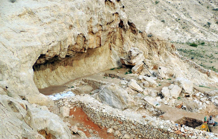
An international team of researchers from the Sharjah Archaeology Authority/United Arab Emirates (UAE) and the Universities of Tübingen and Freiburg as well as Oxford Brookes/England led by Dr. Knut Bretzke from the University of Tübingen and Prof. Dr. Frank Preusser from the Institute of Earth and Environmental Sciences at the University of Freiburg has uncovered startlingly new results that show Palaeolithic humans repeatedly occupied the rock shelter site of Jebel Faya in Southern Arabia between 210,000 and 120,000 years ago; shattering previously held ideas about when, and how, humans first moved into Arabia from Africa.
The researchers have published their findings in the current issue of Scientific Reports.
Jebel Faya, located in Sharjah, UAE, is one of the most important Palaeolithic sites in Arabia. In 2009 excavations revealed human occupation dating back to 125,000 years ago making it the then oldest known human site in Arabia.
Excavations at Jebel Faya Rock Shelter, UAE.
New archaeological data from Jebel Faya, published in Scientific Reports, indicate that human settlement in Southern Arabia occurred under an unexpected range of climatic conditions and significantly earlier than previously thought.
Humans were not dependent on favourable climatic conditions
Previously it has been argued that Arabia was closed to prehistoric humans during dry climate phases and that humans had to wait for periods of more wet climatic conditions in order to expand into the region.
The new results contradict this view and show humans were far more adaptable than previously thought and not reliant on extended periods of favourable climate conditions to thrive.
Using a cutting-edge range of archaeological, palaeoclimatological and dating techniques, the team were able to reconstruct four distinct phases of human occupation between 210-120,000 years ago.
Crucially this demonstrates that humans occupied the site during dry and wetter climate events – challenging previous ideas about when humans could and could not occupy Arabian sites during the Palaeolithic and opening up the possibility that Arabia may yet yield more evidence of the human journey out of Africa during drier phases.
Re-evaluate interactions between humans and the environment
Dr. Knut Bretzke commented: “Most exciting for me personally is that our data provide the first evidence for human occupation of Arabia about 170,000 years ago. This period is traditionally thought to be characterized by extremely dry conditions that must have prevented human presence in Arabia.
We think that the unique interplay of human behavioural flexibility, the mosaic landscapes of South-East Arabia and the occurrence of brief spells of more humid conditions enabled the survival of these early human groups.
To study the details of this interplay and the evolution of the human-environment interdependencies, Jebel Faya and its surroundings are the key area and I am convinced that more surprises will come.”
Prof. Adrian Parker, Oxford Brookes University, who led the reconstruction of the palaeoenvironments, noted that “Our data challenges previous assumptions that human occupation in Arabia was only confined to well-defined wetter climate phases.
Understanding the environmental context is paramount when evaluating human occupation. Well constrained evidence in Arabia is still limited and the complex interrelationships between humans, climate, and environment need careful re-evaluation especially in the light of our findings”.
Luminescence dating elementary for archaeological research
The Freiburg geologist Frank Preusser, who dated the phases of human occupation, said: “The fact that luminescence dating allows determining the time of the last daylight exposure of quartz grains embedded in sediment
layers has revolutionised archaeological research. The study from Jebel Faya is another milestone in enlightening the complex history of our species.”
Ancient Buddhist Temple Unearthed in Pakistan Is One of The Oldest Ever Discovered
An ancient temple dating from the early centuries of Buddhism has been unearthed in the Swat Valley in northern Pakistan — part of the ancient Gandhara region that was conquered by Alexander the Great and gave rise to the mixing of Buddhist beliefs and Greek art.
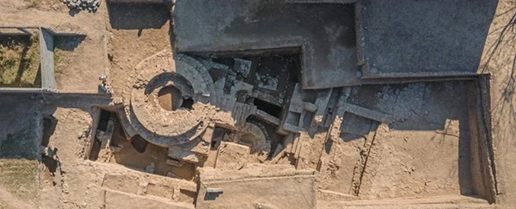
Aerial view of the temple.
Archaeologists think that the temple dates from about the middle of the second century B.C., at a time when Gandhara was ruled by the Indo-Greek kingdom of northern India, and that it was built above an earlier Buddhist temple that may have dated from as early as the third century B.C.
That means people would have built the older temple within a few hundred years of the death of the founder of Buddhism, Siddhārtha Gautama, who lived in what is now northern India and Nepal between about 563 B.C. and 483 B.C.
The excavated remains of the temple found so far, near the centre of the modern town of Barikot, are over 10 feet (3 meters) tall and consist of a ceremonial platform topped by a cylindrical structure that housed a conical or dome-shaped Buddhist monument called a stupa.
The temple complex, which was built and reconstructed several times, also included a smaller stupa, a cell or room for monks, a staircase, the podium of a monumental pillar or column, vestibule rooms and a public courtyard that looked out onto an ancient road.
Radiocarbon dating will establish precise dates of the structures, but the temple at Barikot is clearly one of the earliest Buddhist monuments ever found in the ancient Gandhara region, Luca Maria Olivieri, an archaeologist at Ca’ the Foscari University of Venice and the International Association for the Mediterranean and Oriental Studies (ISMEO) who led the excavations with Pakistani and Italian colleagues, told Live Science.
Ancient and modern
Italian archaeologists, who have been working in Swat since 1955, began the excavations at Barikot in 1984.
Their mission had been to preserve the important archaeology of the city by renting vacant land and excavating as much of it as possible, thereby protecting it against urban sprawl and clandestine archaeological excavations that sought to recover artefacts to sell in the foreign antiquary markets, he said.
Until a few years ago, the excavations at Barikot had included the southwestern districts of the city and the acropolis — but not the city centre, where the land rental costs are very high, he said. (The land at the Barikot sites is often privately owned, and renting it under terms that allow the excavations is simpler and less expensive than buying it.)
But the newly discovered temple was found on land acquired by the provincial archaeological authorities near the centre of the city, which enabled the team to begin excavations there in 2019. Pits made by looters had already suggested something important might be buried there.
“For years, we had been watching what came out of the foundation trenches of modern houses, agricultural excavations and the pits left by clandestine digging,” Olivieri said. “[So] there were hints that there was a large monument there.”
Much of the work of the archaeologists has been to excavate the ancient fortress and another temple at the “acropolis” on the outskirts of Barikot.
Thousands of ancient artefacts have been unearthed in the excavations at Barikot, including the face of a Buddha carved in gray schist.
The temple was located along an ancient road leading to the ancient city’s main Buddhist monument, a 65-foot-wide (20 m) stupa that was revealed by public works a few years ago; it is now the site of an electricity pylon.
In addition to the architectural features of the buried temple, archaeologists have discovered more than 2,000 artefacts at the site, including coins, jewels, seals, pottery pieces, stonework and statues, some of which bear ancient inscriptions that can be used to date them, Olivieri said.
Alexandrian conquest
Barikot is mentioned as “Bazira” or “Beira” in classical sources from the time of Alexander the Great, who conquered the already ancient Gandhara kingdom in 327 B.C. Its name meant “the city of Vajra,” referring to an ancient king mentioned in “The Mahabharata,” a Sanskrit epic poem that is thought to relate events from about the ninth and eighth centuries B.C.
Alexander was the king of Macedon in Greece, and he led military campaigns east against the Persian Empire from 334 B.C., staging an invasion of northwestern India — his farthest conquest — in 326 B.C.
Alexander eventually turned back toward Europe at the demand of his homesick troops, but he died at Babylon in 323 B.C., probably from a disease such as malaria but possibly from poisoning. His generals then divided up his territories; the region of Bactria to the north of Gandhara became ruled by kings of Greek descent, while Gandhara for a time reverted to native Indian rule under the Maurya Empire.
Olivieri said Buddhism was already present in Gandhara by the time of Menander I, a descendent of the Greek kings of Bactria, who established the Indo-Greek kingdom in about 165 B.C. and took over the region, but it may have been limited to the region’s elites.
Later, Buddhism became much more widespread, and Swat became a sacred centre for the religion, especially during the Kushan Empire from about A.D. 30 to A.D. 400 when Gandhara became famous for the Greco-Buddhist style that portrayed Buddhist subjects with the techniques of Greek art.
Swat also has a temperate microclimate, which allows two harvests every year — in spring and late summer — so ancient Barikot was an important centre for the management of the region’s agricultural surplus. As a result, Alexander probably used the region as a “breadbasket” to provision his armies before continuing their military campaign south to India, according to a statement from Ca’ Foscari University of Venice.
Olivieri said the Italian archaeological mission had wrapped up its latest season of excavations at Barikot, but the team will return later this year to make further investigations of the site and hopefully reveal more of the ancient temple.
Rare ‘fish scale’ armour discovered in a Chinese tomb
About 2,500 years ago, a man in northwest China was buried with armour made of more than 5,000 leather scales, a military garment fashioned so intricately, its design looks like the overlapping scales of a fish, a new study finds.
The armour, which resembles an apron-like waistcoat, could be donned quickly without the help of another person. “It is a light, highly efficient one-size-fits-all defensive garment for soldiers of a mass army,” said study lead researcher Patrick Wertmann, a researcher at the Institute of Asian and Oriental Studies of the University of Zurich.
The team called it an early example of bionics or taking inspiration from nature for human technology. In this case, the fish-like overlapping leather scales “strengthen the human skin for better defence against the blow, stab and shot,” said study co-researcher Mayke Wagner, the scientific director of the Eurasia Department of the German Archaeological Institute and head of its Beijing office.
Researchers unearthed the leather garment at Yanghai cemetery, an archaeological site near the city of Turfan, which sits at the rim of the Taklamakan Desert. Local villagers discovered the ancient cemetery in the early 1970s. Since 2003, archaeologists have excavated more than 500 burials there, including the grave with the leather armour. Their findings show that ancient people used the cemetery continuously for nearly 1,400 years, from the 12th century B.C. to the second century A.D. While these people did not leave written records, ancient Chinese historians called the people of the Tarim Basin the Cheshi people, and noted that they lived in tents, practised agriculture, kept animals such as cattle and sheep and were proficient horse riders and archers, Wertmann said.
The armour is a rare find. Leather scale armour discovered in the ancient Egyptian tomb of King Tutankhamun, from the 14th century B.C., is the only other well-preserved ancient leather scale armour with a known provenance.
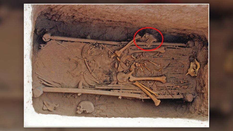
The tomb in Yanghai with the remains of the male individual and the position of the leather scale armour indicated by the red circle
Another well-preserved leather scale armour, housed at the Metropolitan Museum of Art in New York City, dates from the eighth to the third century B.C., but its origin is unknown.
It was a “big surprise” to find the armour, Wagner told Live Science in an email. The researchers found the garment in the grave of a man who died at about age 30 and was buried with several artefacts, including pottery, two-horse cheekpieces made from horn and wood, and the skull of a sheep.
Conservators examine the 2,500-year-old leather scale armour found in a man’s burial in northwestern China.
“At first glance, the dusty bundle of leather pieces [in the burial] … did not arouse much attention among the archaeologists,” Wagner said. “After all, the finds of ancient leather objects are quite common in the extremely dry climate of the Tarim Basin.”
A reconstruction of the body armour revealed that it sported 5,444 small leather scales and 140 larger scales, likely made of cow rawhide, that was “arranged in horizontal rows and connected by leather laces passing through the incisions,” Wagner said.
The different scaled rows overlap, a style that prompted the Greek historian Herodotus to call similarly fashioned armour, worn by fifth century B.C. Persian soldiers, just like “the scales of a fish,” Wagner noted.
A plant thorn stuck into the armour gave a radiocarbon date of 786 B.C to 543 B.C., the researchers found, indicating that it was older than the fish-like armour worn by the Persians. According to the team’s reconstruction, the armour would have weighed up to 11 pounds (5 kilograms).
Utterly unique
The discovery is one of a kind. “There is no other scale armour from this or an earlier period in China,” Wagner said. “In eastern China, armour fragments have been found, but of a different style.”
A deep dive into the history of scaled armour revealed that West Asian engineers developed scale armour to protect chariot drivers in about 1500 B.C. when chariotry became part of the military. After that, this style of armour spread northward and eastward to the Persians and Scythians and eventually to the Greeks. “But for the Greeks, it was always exotic; they preferred other types of armour,” Wertmann told Live Science.
Due to its local uniqueness, it appears that the newly described armour was not made in China, Wagner said. In fact, it looks like Neo-Assyrian military equipment from the seventh century B.C., which is seen in rock carvings, according to The British Museum.
“We suggest that this piece of leather scale armour was probably manufactured in the Neo-Assyrian Empire and possibly also the neighbouring regions,” Wertmann said. If this idea is correct, “then the Yanghai armour is one of the rare actual proofs of West-East technology transfer across the Eurasian continent during the first half of the first millennium B.C.E.,” the researchers wrote in the study.
Photos of the Yanghai leather scale armor, including the end piece of the left side panel’s inside (A) and outside (B).
A photo (top) and illustration (bottom) of the Yanghai leather scale armour.
The different types of leather scales found in the armour, include type A (about 5,159 pieces preserved), type B (about 115 pieces preserved) and type C (about 67 pieces preserved).
How was it worn?
The armour mainly protects the front torso, hips, left side and lower back. “This design fits people of different statures because width and height can be adjusted by the thongs,” Wertmann said. Its left-side protection meant the wearer could easily move their right arm.
“It seems the perfect outfit for both mounted fighters and foot soldiers, who have to move rapidly and rely on their own strength,” he added. “The horse cheek pieces which were found in the burial may indicate that the tomb owner was indeed a horseman.”
However, how the armour ended up in the man’s burial “remains a riddle,” Wertmann said. “Whether the wearer of the Yanghai armour himself was a foreign soldier (a man from Turfan) in Assyrian service who was outfitted with Assyrian equipment and brought it home, or he captured the armour from someone else who was there, or whether he himself was an Assyrian or North Caucasian who had somehow ended up in Turfan is a matter of speculation. Everything is possible.”