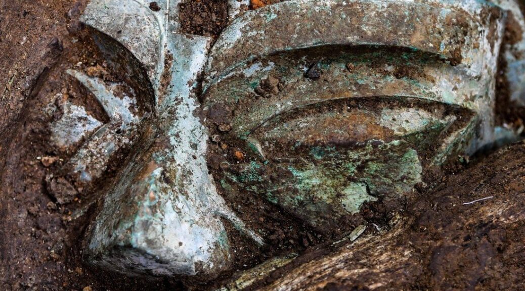
Turkey: Statue of Roman Emperor Hadrian found in southwestern Aydin province
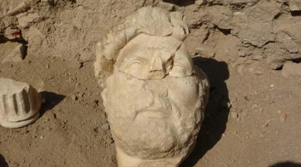
The news was released today that an ancient statue of the famous Roman emperor Hadrian was found in the southwestern Aydin province of Turkey, where the ancient city Alabanda once stood. It has been dated to the 2nd century CE, some 1900 years ago.
This discovery is being placed among the most important archaeological discoveries ever made in Turkey.
The statue is fragmented but the head has survived to our present-day and the original is believed to have been about 2.5 meters tall (8.2 feet).
“The statue, which we found in six pieces, will be one of the most important works in the museum. … For more detailed information about the statue, we are working to find inscriptions containing honorifics.” Ali Yalcin Tavukcu,
lecturer in the Department of Classical Archaeology at Ataturk University.
Hadrian is commonly believed to have ruled from 117 CE until his death in 138 CE.
Ali Yalcin Tavukcu reported that Hadrian visited the city in 120 CE and that this statue was likely created for the occasion.
The culture and tourism director for Aydin, Umut Tuncer, expressed his hope that this discovery will increase the amount of tourism in the area.
The Romans had taken control of the region around the turn of the first millennium CE and their successors maintained control until the Ottomans seized Constantinople in 1453.
Hadrian might be most popularly known today for the wall he is credited with building in Britain, known as Hadrian’s Wall. He built this as a divider and defence against the northerners that he saw as barbarians.
As of now, I have not seen any reports of forensic sciences being applied to the statue to confirm the 2nd century CE date.
Any mentions of dating methods, as well as why they think it’s Hadrian, has been absent from the reports I’ve seen.
More information is sure to be released about this discovery so stay tuned.
Cutting-edge Laser Technology Uncovers Secrets of Maya holy city
The steamy jungles of northern Guatemala don’t reveal secrets easily. For centuries, the overgrown landscape has protected most of the remains of the Maya who once tamed it — yielding slowly to modern scientists seeking to learn more about the ancient civilization known for its sophisticated hieroglyphic script, art, architecture and mathematics.
The Maya civilization began to emerge about 3,000 years ago, and reached its peak during the Classic Period, from about A.D. 250-900.
Now, technology that allows for digital deforestation has uncovered thousands of new Maya structures previously undetected beneath smothering vegetation. For archaeologists like Thomas Garrison, assistant professor of anthropology at Ithaca College, the findings have done far more than recast notions of the size and density of the Central American society.
“Frankly, it’s turning our discipline on its head,” he said.
Garrison helped orchestrate the 2016 aerial survey these revelations stem from. The findings and the technology behind them — LiDAR (light detection and ranging) — will be the focus of a new National Geographic documentary titled “Lost Treasures of the Maya Snake King.” The documentary will follow a NatGeo explorer as he treks deep in the jungle to seek out a pyramid detected in the survey.
Project leader Richard Hansen with the LiDAR system.
Garrison appears in the documentary commenting on the LiDAR mapping and its results. The program will also feature custom-designed images of many of the newly revealed structures, as translated from the data.
Laser Show in the Jungle
LiDAR is a method of mapping from the sky: An aeroplane-mounted device sends a constant pulse of laser light across a swath of terrain; precise measurements of how long it takes the emitted breams to bounce off surfaces are taken and translated into topographic data.
The LiDAR system was mounted on this small plane.
The laser pierces through the smallest gaps in the vegetation to record the lay of the land below with remarkable accuracy. The resulting data can be tweaked to filter out the trees, thus offering an unencumbered view of everything else on the surface.
The technology is a boon for surveys in jungles like those in lowland Guatemala, where dense canopy hinders other methods of aerial survey and thick undergrowth can conceal the relationship even between known structures.
“In that kind of environment where you can’t see [a few feet in front of yourself], it’s very hard to piece that all together,” Garrison said. In a swampy area of rolling hillocks rising from the muck, for example: “You have this idea that there’s some little stuff on the hills, but the LiDAR lets you see it in its totality.”
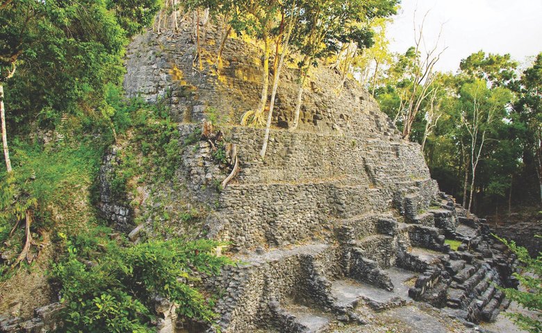
The survey of 2,100-square kilometres encompassed several major Maya sites, including the largest at Tikal, and El Zotz, where Garrison focuses his research.
The LiDAR mapping revealed over 60,000 previously unknown structures in total, from unknown pyramids, palace structures, terraced fields, roadways, defensive walls and towers, and houses. Archaeologists are realizing that the ancient population centres they’ve spent decades studying are much bigger than they speculated.
With Global Conservation’s support, scientists mapped more than 60,000 houses, palaces, canals, and other man-made structures that had previously been obscured by the thick jungle. Image courtesy Mirador Basin Project.
El Mirador from the air. Without LiDAR to penetrate the dense rainforest canopy, this area simply looks like a vast expanse of wilderness. A straight line through the trees in the lower third of the image hints at the massive, ancient causeway below. Only with LiDAR could scientists begin to understand the true extent of the ancient city (below).
A three-dimensional rendering of the ancient city of El Mirador, produced from LiDAR data. To the naked eye, this area simply looks like a vast expanse of rainforest (above). Image courtesy Mirador Basin Project.
“Everyone is seeing larger, denser sites. Everyone,” Garrison said. “There’s a spectrum to it, for sure, but that’s universal: everyone has missed settlement in their [previous] mapping.”
Especially telling to Garrison are newly revealed agricultural features that would be necessary to support the lowland Maya population during their centuries of civilization — population estimates have now expanded from a few million to 10-20 million — and defensive structures that suggest warfare was far more prevalent than previously known.
Only the Beginning
The LiDAR survey is a collaboration between archaeologists from the U.S., Europe and Guatemala, and the Fundación PACUNAM (Patrimonio Cultural y Natural Maya), a Guatemalan philanthropic and cultural heritage preservation organization.
Garrison serves as one of the archaeology advisors to the project and was fundamental in lobbying for the survey, which is now the single largest ever conducted in the field of Mesoamerican archaeology. Fundraising is already taking place for a second LiDAR survey of similar size, he said.
The LiDAR findings are only the beginning. There is still much to discover about the rise, peak and fall of the Maya civilization. The LiDAR data points to new areas where those answers may be found through fieldwork and excavation.
An artist’s rendering of the ancient city of El Mirador.
“That’s the challenge now. Now we have so much data,” Garrison said. “How do we handle it and how do we move forward with it? We’ve still got to get to those places, we’ve still got to check them out.
“It’s difficult to convey how exciting this time is for us.”
2,200 year-old mythological masks unearthed in Turkey’s Mugla
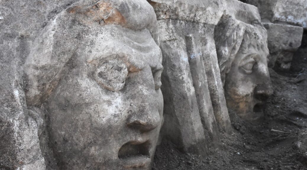
Archaeologists in southwestern Turkey’s Muğla have recently uncovered 10 rock carvings of mythological masks in the ancient city of Stratonikeia.
An archaeologist works on a face mask in the ancient city of Stratonikeia, Muğla, southwestern Turkey.
An excavation team, headed by professor Bilal Söğüt of Pamukkale University, continues year-round work at the ancient city, where artefacts from the Hellenistic, Roman, Byzantine, Anatolian beyliks (principalities), Ottoman and Republican periods have been found.
The team had already cleaned and repaired 33 face carvings, unearthed them over the last two years, and prepared them for display. Their latest efforts uncovered 10 more masks at a 2,200-year-old ancient theatre, taking the total number of masks to 43.
An aerial view from the 2,200-year-old theatre in the ancient city of Stratonikeia, Muğla, southwestern Turkey
Speaking to Anadolu Agency (AA), Söğüt said the 3,000-year-old ancient city, which is on the UNESCO World Heritage Tentative List, bears traces from every period of history.
He added that they have been working on different structures, some dating back to antiquity, in the city.
“We have been working at the ancient theatre for two years. We found 33 face moulds during our excavations here.
Today, we unearthed 10 more. Hopefully, we will be able to find all the masks at the theatre in their own places and arrange them in their original order. That will be very pleasant for us,” he said.
Two masks in the ancient city of Stratonikeia, Muğla, southwestern Turkey.
Söğüt explained that the masks surround the stage of the ancient theatre.
“When people came here in ancient times, they were impressed by the splendour and magnificence of the theatre even before entering it. We have been slowly uncovering its richness and splendour.
This also the value ancient people gave to culture, art and architecture.”
He said besides the characters in the plays performed at the theatre, the masks depict ancient gods and goddesses, as well as animal figures.
“We have brought the blocks with face masks to the city’s ‘stone hospital’ for cleaning and conservation.” The newly discovered masks will also be put on display once the work is complete, said Söğüt.
1,500-Year-Old Temple Ruins Discovered in Uttar Pradesh, India
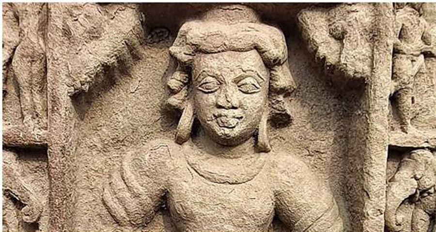
The Archaeological Survey of India (ASI) has found remains of an ancient temple dating back to the Gupta Period, 5th Century CE in Bilsarh village of Uttar Pradesh’s Etah.
At the spot, the archaeologists discovered “two decorative pillars (at the spot) close to one another, with human figurines (found earlier).” Vasant Swarnkar, superintending archaeologist of ASI’s Agra circle said, “To understand their significance, we conducted further excavation and found the stairs,” quoted The Times of India.
Last month, the staircase was excavated has Shankhalipi inscriptions that were ” deciphered as saying ‘Sri Mahendraditya’, which was the title of Kumaragupta I of the Gupta dynasty.”
A breakthrough discovery by @ASIGoI’s Agra Circle – Stairs leading to the Gupta period temple were found through scientific cleaning at the protected site of Bilsarh, Etah.
An inscription in Shankh lipi on one of the steps, datable to 5th century CE, Gupta period, possibly reading “Sri Mahendraditya..”, identified as Kumargupta of the Gupta dynasty has been unearthed.
Shankhalipi is an ancient script that was used from the 4th to 8th centuries CE for names and signatures.
In the 5th century CE, Kumaragupta I ruled for 40 years over what is now north-central India.
The ASI made the discovery in Etah’s Bilsarh village, which has been protected since 1928, during a routine check-up. The ASI scrubs its protected sites during monsoons.
The Shankhalipi inscription was earlier found on a horse status found in Lakhimpur Kheri and is now at the State Museum in Lucknow, the TOI reported.
The remains recently found in Etah are the third structural temple found so far from the Gupta period. “Before this, only two structural temples were found — Dashavatara Temple in Deogarh and Bhitargaon Temple in Kanpur Dehat.
The Etah pillars are well-sculpted, better than the earlier examples in which only the lower sections were carved. The decorative pillars and staircase are a bit more advanced than the earlier ones,” said History Professor Manvendra Pundhir of the Aligarh Muslim University.
He said, “The Guptas were the first to build structural temples for Brahminical, Buddhist and Jain followers. Prior to that, only rock-cut temples were built,” quoted TOI.
A treasure trove of antiquities has been discovered in southwest China at one of the world’s most remarkable archaeological sites
Some scholars have said the Sanxingdui ruins in southwest China’s Sichuan Province are more important than the Terracotta Army in Xian.
Scientists at one of China’s most important archaeological sites continue to unearth remarkable artefacts from an ancient Chinese civilisation that dates back over 3,000 years. Researchers on Thursday revealed over 500 artefacts discovered at the Sanxingdui ruins in southwest China’s Sichuan province
The findings included extremely detailed bronze statues, jade and ivory artefacts as well as a fully preserved gold mask. The new gold mask was reminiscent of one that awed the world back in March, which was far more damaged than the latest revelation. The first mask was so unique it had some people speculating that aliens once inhabited the area
Scientists told China Daily that the mask was found in June and it is consistent with the hypothesis that gold was important to people of the area, called the Shu kingdom. The gold mask is the largest, and most well preserved, of similar golden artefacts discovered at the site. It stands at 37.2cm wide and 16.5cm tall.
A head-turned kneeling bronze figure was discovered at the Sanxingdui ruins over the summer.
A well preserved gold mask was the pièce de résistance of the recent announcement at Sanxingdui.
Scientists believe that the masks were manually shaped by ancient people and had not been melted down and poured into a cast. The mask has similar facial features to bronze statues discovered in the area. It has large eyes covering much of the face, a big nose, gigantic ears and a flat, wide, mouth.
The strange facial features led some people to suggest they were representatives of extraterrestrials, an idea thoroughly debunked by Wang Wei, the director of the Institute of Archaeology at the Chinese Academy of Social Sciences.
“There is no chance that Sanxingdui belongs to an alien civilisation. These wide-eyed masks look exaggerated because the makers want to emulate the look of deities. They shouldn’t be interpreted as the look of everyday people,” Wang said in March.
This bronze statue discovered in Sanxingdui shares the same facial structure as the gold mask.
Besides the mask, other discoveries included bronze statues, a knife made out of jade and a series of artefacts made of ivory, among many others.
Scientists said the artefacts discovered at Sanxingdui had transformed the perception of the creativity and ingenuity of the people who lived in China thousands of years ago.
A jade knife that might be thousands of years old looks like it could be used to spread butter today.
While scientists are confident that the pits are not the remnants of an alien civilisation, they do not know what they are. The most common hypothesis is that it was an ancient burial ground, but that idea has not been sufficiently confirmed.
One scientist, Lei Yu, a leader of the Sanxingdui dig, told the South China Morning Post in June that he hopes to find ancient text.
“Because these people could create advanced and developed bronze, there must be text in such a high level of civilisation. We need to find it,” he said.
Scientists said the bronze statues found in Sanxingdui are unique to other discoveries in the country.
Many of the bronze artefacts are brand new discoveries and unique to anything found before in China. They are highly detailed, with statues showcasing facial features that bear a striking resemblance to the gold mask.
The artefacts give insights into the ancient Shu kingdom, home to a mysterious civilisation that was the source of legend until the recent discoveries proved its existence. One of the artefacts revealed this week was a vessel called a zun, which is commonly found across ancient Chinese culture. It was used to hold wine.
The archaeology site is providing insight into a culture that was relegated to legend until recently.
The Sanxingdui zun features detailed birds halfway down the vase and large spirals along the base engraved with smaller spirals to add detail.
Zuns come in all shapes and sizes and are sometimes built to appear like animals. Zuns were commonly used during the Shang dynasty (1600-1046 BC), and can be found in Chinese cultures as late as the end of the northern Song dynasty in 1126.
Scientists believe this piece of pottery was a zun, a vessel used to hold wine by many Chinese cultures across the millennia.
Artefacts near Sanxingdui were first discovered in 1929 by a farmer who found jade artefacts while digging a well. But the first professional excavation did not happen until 1986 after kiln workers accidentally uncovered more artefacts.
That original excavation in the 1980s was a low-budget affair, with scientists using simple shovels to dig. They shared one camera to gather evidence and used bicycles to transport their discoveries.
Lei, who was also part of those original digs in the 1980s, said in June that, “Archaeology was difficult at that time because it was salvage excavation due to the many brick factories around. Farmers dug up soil to make bricks and we did our excavation wherever they dug.”
Inscriptions were found on the outside of a cong made of jade. A cong is a cylindrical piece of pottery but scientists do not know what it was used for.
Today, the ruins at Sanxingdui leverage the best technology has to offer. Workers surrounded the pits with transparent walls and built a sterilised room that maintains an environment of 80 per cent humidity and 20 degrees Celsius.
Semi-permanent laboratories were built at the site so archaeologists can quickly analyse both organic and inorganic material. The rooms were designed so that scientists have minimal contact with the artefacts when they move around. The site hosts dozens of teams from across China working to uncover the latest remarkable discovery.
Workers cover themselves in protective gear to make sure they do not contaminate the artefacts.
Chinese scientists told Xinhua they are entering a “critical stage” and expect to find an array of artefacts that change how archaeologists think about ancient China. The site is about 60km from Chengdu, the capital of Sichuan, and some scholars have said it is more important than the Terracotta Army further north in Xian.
Scientists said the public should expect more revelations in the near future.
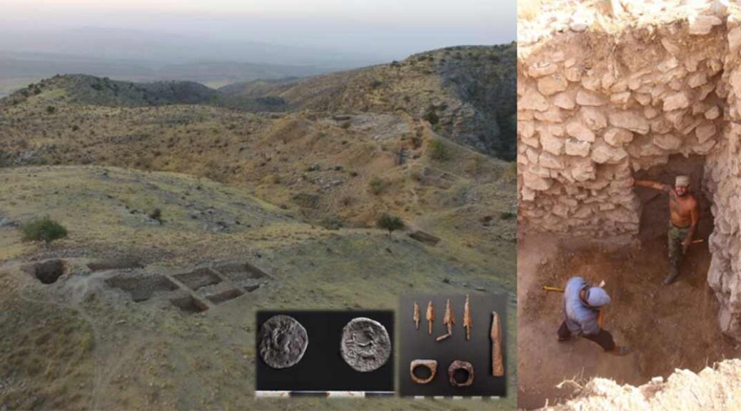
First Excavations at 2,300-Year-Old Bactria Kingdom Fortress Completed
Archaeologists from the Russian-Uzbek archaeological expedition has conducted the first excavations of the Bactrian fortress of Uzundara, a border outpost that protected ancient Bactria during the Hellenistic period.
Uzundara was part of a wider system of fortifications in the present-day Boysun region of Uzbekistan, that protected the northern borders of Bactria from raiding nomads.
Data from GPR studies and tachymetric surveys have established that the fortress consisted of the main quadrangle, a triangular citadel, and an outer wall reinforced with 13 rectangular towers.
The fortress was built around the early 3rd century BC, during the reign of Antiochus I of the Hellenistic Seleucid Empire. During the reign of Eucratides I of the Diodotid dynasty, Uzundara was destroyed in a nomad assault on the Bactrian borders.
In recent excavations, archaeologists have uncovered one of the defensive towers, sections of the fortress wall, and a significant number of artefacts, which confirms that the fortress was rebuilt at the beginning of the 3rd century BC, and abandoned in the 2nd century BC.
The fragmented iron umbilicus of a fire rap shield
In the upper layers of the inner-wall galleries, the team excavated coins of Euthydemus I, who ruled around 235-200 BC, whilst in the lower layers belonging to the early stage, weapons and a coin of the Alexander type were unearthed.
In the outer gallery of the fortress wall adjacent to the north-eastern tower, a fragmented iron umbilicus of a fire rap shield was also discovered.
Nigora Dvurechenskaya from the Russian Academy of Sciences said: “Excavations have shown that the fortifications are perfectly preserved.
For the first time since the destruction of the fortress, the walls of Uzundara saw the light again: we uncovered half of the corner tower, which remained two stories high, opened the passage and the fortress walls with two galleries, which survived to a height of up to three meters.”
Dark secrets of Korea’s famous Wolseong palace complex are unearthed
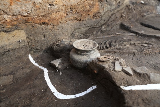
Korea JoongAng Daily reports that a young woman’s remains have been unearthed at the site of Wolseong, a Silla Dynasty (57 B.C.–A.D. 935) palace complex in eastern South Korea.
Remains of an adult female from 1,500 years ago were found in Gyeongju, North Gyeongsang, at the site of a palace complex known as Wolseong. Intact pottery was found next to the head.
Until 2017, the legend of Koreans’ practice of human sacrifice during large-scale construction to pray for the building to stand firm for a long time, remained a horrific myth. However, the archaeological discovery of human remains in Wolseong, a palace complex of the Silla Dynasty (57 B.C.-A.D. 935) located in Gyeongju, North Gyeongsang, turned this myth into fact.
Remains from two people from the fifth century were discovered near the west entrance of Wolseong, throwing the nation into a state of shock. One was of a male and the other was a female. It was the country’s first archaeological evidence that proved that human sacrifice may have been a common practice for Silla people.
Remains of another female adult have been discovered, just 50 centimetres (1.64 feet) above the area where the couple was found in 2017, the Gyeongju National Institute of Cultural Heritage announced on Tuesday.
“Like the remains discovered in 2017, the recently discovered remains of a female adult showed no sign of struggle,” said Jang Ki-myeong, a researcher at Gyeongju National Research Institute of Cultural Heritage.
The woman, like the other two bodies, was laid to face the sky and is believed to have been in her 20s when she was sacrificed. The couple found in 2017 were in their 50s.
An x-ray of the discovered pottery shows a smaller pot inside the larger one
“The first thing we do when we find human remains is figuring out the gender and age,” said Kim Heon-Seok, another researcher from the institute. “Though her remains were also in good condition, her pelvis, which we use to find out the gender, was damaged, so we had to look at other things like her physique and height to figure it out.”
Like the two Silla people discovered in 2017, researchers believe the sacrificed humans are probably from lower-ranking class as they were “all quite undersized and had nutrition imbalances as seen from their teeth.”
Intact pottery was also discovered next to her head. Back in 2017, four pieces of pottery were found next to the feet of the sacrifices.
“When we did an x-ray of the pottery, we found a smaller bowl inside the jar. It looks like the larger pottery carried alcohol or some kind of liquid. It was buried together with the body,” said Jang. “This is not a common feature you witness in ancient tombs, but something similar was found at the 2017 site.”
When the remains of the two bodies were discovered, some raised the possibility that their deaths could have been accidental. But, the Cultural Heritage Administration concluded that the evidence — the remains showing no signs of struggle and the discoveries of animal bones and objects used for ancestral rites in the same area — clearly points that the pair died as part of a sacrificial ceremony.
“Now with the additional discovery, there’s no denying Silla’s practice of human sacrifice,” said Choi Byung-Heon, professor emeritus of archaeology at Soongsil University, adding that the specific location of where the remains were discovered is also important. According to Choi, the remains of three Silla people were laid on top of the bottommost layer of the fortress’s west wall, right in front of where the west gate would have been located.
“After finishing off the foundation and moving onto the next step of building the fortress, I guess it was necessary to really harden the ground for the fortress to stand strong. In that process, I think the Silla people held sacrificial rites, giving not only animals but also humans as sacrifices,” said Choi.
Geology Professor Lee Seong-Joo of Kyungpook National University also said there are records of human sacrifices in neighbouring China, by people of the Shang Dynasty (1600-1046 B.C.) when constructing large buildings and these sacrifices were commonly found near entrances.
“Historical records say such rituals were carried out before making the gates or just before engaging in the most important part of the construction process,” Lee said.
“Samguksagi,” or “The Chronicles of the Three States” states that Wolseong was built in year 101 and was used for 800 years as the residence of Silla kings until Silla gave way to the Goryeo Dynasty (918-1392). But by studying the pieces of pottery unearthed from the fortress, researchers predicted the date of its construction to be somewhere between the fourth and fifth centuries.
The remains of adult females were discovered just 50 centimetres (1.64 feet) above the remains found in 2017.
There’s been a clear gap between the two, and debates among researchers. The Gyeongju National Research Institute of Cultural Heritage said it has managed to settle the debate by scientifically proving that the construction period began in the early fourth century and it took about 50 years to complete.
“By analyzing the data collected through a newly adopted technology known as AMS [Accelerator Mass Spectrometer] and cross-checking with the existing data we have, we were able to provide a more reliable construction period,” said Jang from the institute.
Does that mean there are factual errors in Korea’s historical documents?
Jang says it’s better to approach the issue as, “Why is it recorded as 101?”
“We should further the research on Wolseong and try to find out what may have resulted in making such a record,” Jang added. “Wolseong is a vast research area not only in terms of its literal size but also academically and historically.”
Wolseong, Korea’s Historic Site No. 16 and a Unesco World Heritage Site, can be literally translated as “moon castle” in English.
The official excavation research of Wolseong began in December 2014.
Literally translated as “moon castle” in English, Wolseong, which is also listed at Unesco World Heritage, measures more than 200,000 square meters and is considered one of the most important historical sites in Korea as it was the seat of the Silla Dynasty. Compared to its historical weight, the Wolseong area had been left largely unexplored.
The government previously conducted several different inspections and excavations, which resulted in the discovery of the remains of 20 Silla people, just 10 meters away from the site where the recent remains were discovered, during two separate inspections in 1985 and 1990. Researchers at the Gyeongju National Institute of Cultural Heritage believe the discoveries are of great significance but have yet to conclude if the remains were part of sacrificial rites.
“As for the remains of the 20 people, only three people’s remains were in good condition while the rest were just scattered across a vast area with animal bones,” said Jang. “It is certain that they are related to Wolseong but we need to conduct more research to find out if they were human sacrifices.”
Researchers believe they may discover more human remains in Wolseong, but more importantly, “so much more about the unknown 1,000 years of Silla,” said Jang.
“We’ve discovered the method of building Wolseong, which mainly used soil,” said Ahn So-Yeon, a researcher from the institute. “We’ve discovered how Silla people mixed stones, pieces of wood, seeds of fruits and grains with soil to make the fortress stronger.”
Professor Lee from Kyungpook National University said Silla had built the strongest and highest fortress compared to Goguryeo and Baekje.
“The fundamental power of unification can also be found in the fortress. A more specific time period and the revealed methodology are significant to the researchers of this field,” Lee said.
A coffin that was found in a golf course pond contains a 4,000-year-old man buried with an axe
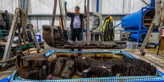
Archaeologists in England have analyzed a half-ton coffin dating to the early Bronze Age that was found under a golf course in Lincolnshire county. The coffin, cut from a single oak tree and thought to be about 4,000 years old, contained human remains, a hafted axe, and a bed of plant material meant to cushion the body in its eternal slumber.
Ian Panter, the head of conservation at the York Archaeological Trust, with the coffin.
Maintenance workers discovered the burial in July 2019 while tending to a water hazard at the Tetney Golf Club in Grimsby. The coffin was under a gravel mound, a special situation that indicates a certain amount of community involvement in the burial.
As is standard for objects of historical significance found in England and Wales, the find was reported to the Portable Antiquities Scheme, which processes such reports and ensures that the objects are properly handed.
Objects made of old wood (think shipwrecks, coffins, and even ship burials) are prone to disintegration when they are removed from water or soil after millennia and exposed to sunlight and air.
To prevent that from happening to the find, the excavated objects were immediately put in bags filled with groundwater, and the coffin was put in cold storage for a year. Afterwards, the coffin was moved to the York Archaeological Trust, where conservators have been working on it and the associated artefacts, including an axe.
Ian Panter works on the 4,000-year-old oak coffin.
“The man buried at Tetney lived in a very different world to ours but like ours, it was a changing environment, rising sea levels and coastal flooding ultimately covered his grave and burial mound in a deep layer of silt that aided its preservation,” said Tim Allen, a Sheffield-based archaeologist for Historic England, in a York Archaeological Trust press release.
An interesting component of the work was the environmental analysis of the plant bedding. Hugh Willmott, an archaeologist at the University of Sheffield who participated in the excavations, said on Twitter that moss, yew or juniper, hazelnuts, and leaf buds were found in the coffin.
The types of floral remains indicated that the burial likely took place toward the end of spring some four millennia ago when a few woolly mammoths still survived. Willmott said in an email to Gizmodo that the hazelnuts may have been a food offering, while the moss could have been a sort of bed for the deceased.
Not much is currently known about the human remains, though the archaeological team suspects it was an individual of some social importance. Willmott said that initial attempts to extract DNA have been unsuccessful.
Dating the coffin is still ongoing—the archaeologists need to do a combination of dendrochronology and radiocarbon dating, which they can cross-reference to find out the year the tree was felled, give or take a couple of years.
The long-shafted axe found in the coffin has a small head.
A shockingly well-preserved axe was found with the person; the handle looks like it could have been varnished yesterday. The axe head is a combination of stone and fossilized coral.
Based on the object’s shape and size—the axe head is less than 4 inches across—the team believes it was a symbol of authority rather than a practical tool. There are very few of such axes known in Britain, perhaps only 12, according to York Archaeological Trust, making this one of the most eye-catching elements of the discovery.
The wooden coffin joins some 65-odd objects as it found around England. Preservationists said in the same release that the axe should be fully preserved within the year, but the coffin will take at least two years to fully treat, due to the object’s size.
This research comes on the heels of the University of Sheffield’s decision to close its archaeology department, as reported by the BBC in July, and the University of Worcester announcing the closure of its archaeology department, also reported by the BBC.
The Campaign to Save British Archaeology was launched in response to the closures. This trend is a troubling one. Had the Sheffield archaeological team not been close by when the Bronze Age coffin was unearthed, the cultural heritage could’ve quickly deteriorated.
Thanks to the quick thinking of the nearby archaeologists, the objects are being preserved and will be displayed at The Collection Museum in Lincolnshire.