2,000-year-old Roman millstone found with massive penis engraved on it
Archaeologists found a Roman millstone unearthed in Cambridgeshire with an engraving of a penis. The inscription, which was a symbol for strength and virility, was thus deciphered.
Over the course of several months, as part of roadwork for an extensive 21-mile section of the A14 between Cambridge and Huntingdon, a millstone and others were discovered.
The finds came from the remains of a Roman villa located near the town of Godmanchester, a Highways England spokesperson told MailOnline.
However, the phallographic carving — which was made to give the millstone and its flour good luck and protection — was only recently identified by experts.
The upgraded stretch of road was opened to traffic in the May of last year — but the millstone was not the only archaeological find revealed before the works finished.
Other finds included the tusk of a woolly mammoth, the skull of a woolly rhinoceros, an abandoned medieval village, and three dismembered men from 1,500 years ago.
Woolly mammoth and rhino remains also found along the road are thought to date back to the last Ice Age
Archaeologists also found the earliest known evidence for beer brewing in Britain, which dated back to as early as 400 BC.
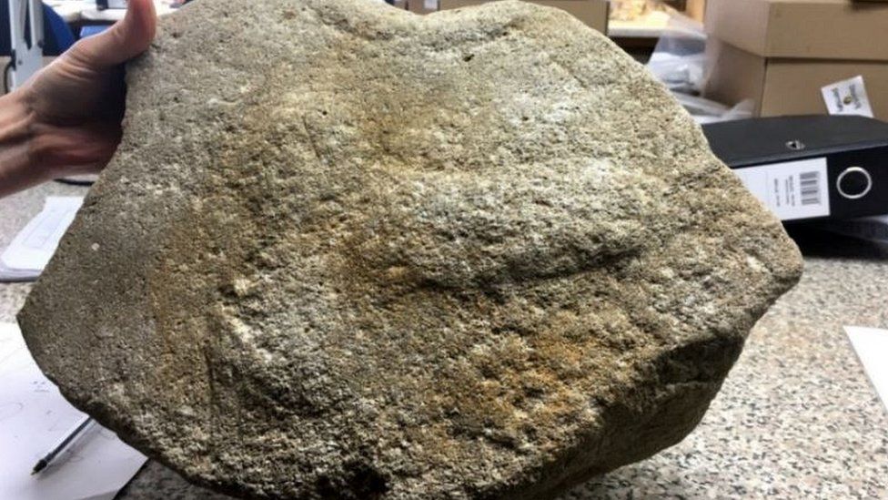
A Roman millstone found near Cambridge was decorated with an engraving of a penis — an ‘image of strength and virility’ — archaeologists have revealed. Pictured, the millstone
According to Highways England’s Archaeology lead for the A14, Steve Sherlock, the penis-decorated millstone is important as it ‘adds to the evidence for such images from Roman Britain.’
‘There were known associations between images of the phallus and milling, such as those found above the bakeries of Pompeii, one inscribed with Hic Habitat Felicitas — “You Will Find Happiness Here”,’ he explained.
‘The phallus was seen as an important image of strength and virility in the Roman world, with it being common practice for legionaries to wear a phallus amulet, which would give them good luck before the battle.’
The millstone was examined by experts from the Museum of London Archaeology Headland Infrastructure and Oxford Archaeology.
Alongside the carving of the phallus on the millstone’s upper face, the team discovered two crosses that had been inscribed on its circumference.
The quern itself would have been a simple hand mill, such as typically consists of two circular stones between which corn is ground.
According to the archaeologists, the millstone appeared to have been broken during use and subsequently adapted to be used as a saddle quern — a base stone in the grinding process — which would have hidden the genital image from sight.
The millstone was examined by experts from the Museum of London Archaeology Headland Infrastructure and Oxford Archaeology. Alongside the carving of the phallus on the millstone’s upper face, the team discovered two crosses that had been inscribed on its circumference. Pictured, Oxford Archaeology expert Ruth Shaffrey, poses with the phallus-bearing millstone.
The researchers reported that more than 300 querns millstones were recovered during archaeological work on the A14 upgrade project.
Decorated querns and millstones of any date are rare — and only four Roman millstones have ever been discovered from around a total of 20,000 nationwide. While crosses on such stones are more prevalent, these tend to be found only at military sites, the team explained.
‘As one of only four known examples of Romano-British millstones decorated this way, the A14 millstone is a highly significant find,’ said Oxford Archaeology’s worked stone specialist, Ruth Shaffrey.
‘It offers insights into the importance of the mill to the local community and to the protective properties bestowed upon the millstone and its produce (the flour) by the depiction of a phallus on its upper surface.’
Two Roman-era Sarcophagi Unearthed in Central Israel
According to a statement released by The Friends of the Israel Antiquities Authority, two 1,800-year-old sarcophagi were unearthed at Ramat Gan Safari Park during construction work at its wildlife hospital.
The new building, designed to offer sophisticated veterinarian facilities for birds and mammals, houses a specialist operation theatre and a large bird nursery that will provide quiet, heated housing for the frequent feeds needed during the chick-rearing seasons.
During its construction, an extraordinary discovery was made last week – two unique sarcophagi, ancient stone coffins, were found in the earthworks.
Veteran safari workers present at the time said that the coffins had been found years ago in the area of the safari’s parking lot.
At the time, the sarcophagi were moved to a location near the veterinary clinic and the African savanna zone. Still, over the years, they were forgotten and became buried under sand and thick vegetation.
When work on the new wildlife hospital began a few days ago, the contractor working in the area started digging. Suddenly, Rami Tam, head of the African savanna zone, noticed the two coffins jutting out of the soil.
He quickly called animal health and management director Shmulik Yedvab, who came to see the find and contacted Alon Klein and Uzi Rothstein at the Israel Antiquities Authority’s Theft Prevention Unit.
Hardly believing their eyes, the inspectors were astonished to see sarcophagi of this kind at the Safari Park. After a thorough examination, they excitedly confirmed the unique find’s great age.
Based on the stones and their ornate decoration, the sarcophagi were intended for high-status people who were buried near the Safari Park.
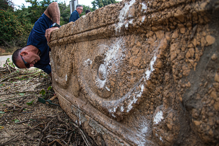
According to Israel Antiquities Authority archaeologists, the sarcophagi are roughly 1,800 years old and date from the Roman period. They are ornamented with symbolic discs – to protect and accompany the soul on its journey to the afterlife – and flower garlands, often used to decorate sarcophagi in the Hellenistic period as well.
Between the garlands are oval blanks, which the archaeologists believe were originally intended to be filled with a customary grape-cluster motif, but for some unknown reason, the work remained unfinished.
The sarcophagi, made of local stone – probably from the Judean Hills or Samaria – are locally-produced imitations of the prestigious sarcophagi made of Proconnesian marble from the Turkish island of Marmara.
Found together, the two sarcophagi bear identical ornamentation, and they may have been made for a husband and wife or for members of the same family. The exact provenance of the sarcophagi is unknown.
Still, they were probably buried near the Safari Park, in the region of Messubim – the site of ancient Bnei Brak in the Roman period, known to us from the Passover Haggadah.
The wealthy owners of the sarcophagi, buried with their grave goods, had no idea that the coffins would find a place of honour alongside giraffes, elephants, and a bird nursery. On Tuesday of this week, the sarcophagi were transferred to their rightful location in the Israeli National Treasures repositories.
6,500 Medieval Coins And Gold Rings Found In A Field
A newly uncovered medieval silver cache that contains thousands of silver coins and this trove of precious metal was found in a Polish cornfield by archaeologists working with the help of a priest and local firefighters.
It is a rare treasure that was discovered in Słuszków, a village in west-central Poland, it was a nearly 900-year-old hoard, It is said to contain one of a kind treasure; a gold ring etched with a Cyrillic inscription that translates to: “Lord, may you help your servant Maria.”
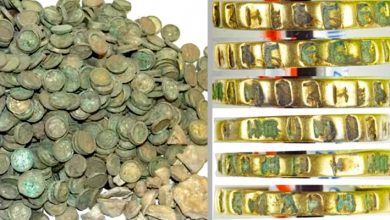
That ring may have belonged to a princess; the coin stash was certainly fit for one. “The newfound hoard consists of over 6,600 items — silver coins and silver clumbs (tiny ingots) … wrapped in three linen pouches, packed in a basket and then put in the ceramic vessel,” Adam Kędzierski, an archaeologist at the Institute of Archaeology and Ethnology at the Polish Academy of Sciences, told Live Science in an email.
Kędzierski said he wouldn’t have found the medieval hoard without the help of a local priest. In November 2020, Kędzierski visited Słuszków to learn more about another medieval treasure — one of the largest coin hoards ever found in Poland, which had been unearthed in 1935.
The exact location of the 1935 hoard had never been recorded, and Kędzierski hoped to locate and photograph it for an upcoming book. However, during his stay, Kędzierski happened to talk with a priest, Rev. Jan Stachowiak, who shared a little bit of gossip about the possible location of another hoard.
The excavation site of the medieval hoard
After using a metal detector to locate the general area where the hoard was buried, Kędzierski and his colleagues dug up a small trench in a cornfield in the village. There, he found a ceramic vessel that held the medieval riches.
“The vessel itself, buried only 30 centimetres [nearly 12 inches] under the ground, was completely preserved — only the lid/the upper part was missing,” he said.
After realizing the hoard’s incredible value, Kędzierski and his team called in local volunteer firefighters to guard the treasure until the excavation was complete, according to The First News, a Polish news outlet.
Most of the coins were silver coins known as cross denarii, minted with the image of a large cross and dating to the end of the 11th century or the beginning of the 12th century, he said. The hoard also held Czech, Danish, Hungarian and German coins, including a denarius coin of Germany’s King Henry III.
A denarius (silver coin) of Henry III, king of Germany
The “rarest coins” are denarii featuring Sieciech, a high-ranking Polish statesman who served Władysław I Herman, the Duke of Poland from 1079 to 1102, Kędzierski said. The hoard’s “biggest sensation,” are four golden rings, including the ring with the Cyrillic inscription about the woman named Maria, he said.
The four gold rings found in the medieval hoard
Unlike silver trinkets, gold jewellery was extremely rare in Poland during the early Medieval period, Kędzierski said. Perhaps, the newfound gold rings belonged to the first ruling dynasty of Poland, known as the Piast dynasty.
“The treasure (dated back to 1105) might have belonged to Zbigniew, Duke of Poland and the wedding band wearing the Cyrillic inscription could have been a gift of his grandmother — Dobroniega Maria, a daughter of Vladimir the Great, Prince of Kiev, and a wife of a Polish price, Casimir the Restorer,” Kędzierski said in the email.
Now that the hoard has been excavated, researchers will analyze and date the gold and silver pieces as well as the linen pouches and the basket that held these treasures. “Particularly interesting will be establishing the provenance of the gold decoration items,” such as the rings, Kędzierski said.
The discovery of this second hoard at Słuszków suggests that the village may have played a more important role in history than previously realized. Perhaps a high ranking official tied to the duke lived in Słuszków, or maybe it was even a temporary residence for Duke Zbigniew, Kędzierski said.
Słuszków is known for other early medieval artefacts; over the years, local farmers have told archaeologists about early medieval vessels and dishes found in their fields, “which may be a sign of [the] remains of stone buildings in the area of Słuszków,” Kędzierski said.
Ancient Roman Library Discovered Beneath German City
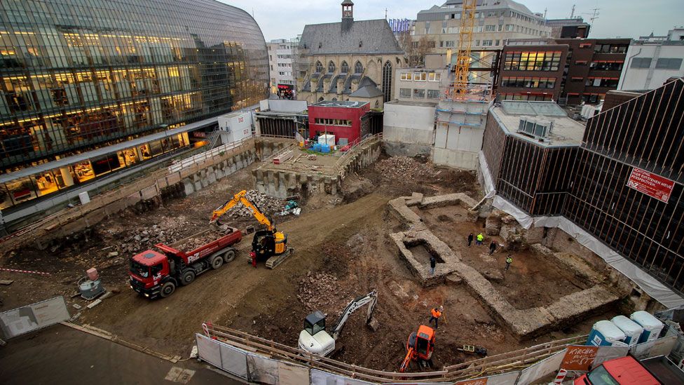
The first thing the archaeologists realised when they discovered the foundations of a Roman-era building situated in the heart of Cologne, Germany, they initially thought they had found the ruins of a public assembly hall.
Archaeologists identified the library based on a series of wall niches that once housed ancient scrolls
The discovery of tiny wall niches, however—at roughly 31 by 20 inches, the spaces were too small to hold statues—soon led them to conclude otherwise: Here, in the former Roman city of Colonia, stood the country’s oldest known library.
According to the Guardian’s Alison Flood, the wall niches mirror those seen in the Library of Celsus, a 2nd-century Roman building located in modern-day Ephesus, Turkey. (Although that structure’s interior was destroyed by an earthquake in the 3rd century, with the facade following in the 10th or 11th century, Celsus was re-erected by archaeologists during the 1970s.)
Based on this connection, researchers were able to identify the niches as all that remained of cupboards built to house an ancient library’s roughly 20,000 scrolls.
The Cologne structure was built in the southwest corner of the city’s forum, or marketplace, sometime between 150 and 200 C.E., according to Martin Oehlen of German news outlet Kölner Stadt-Anzeiger.
The Romans had founded Cologne, then known as Colonia, on the banks of the Rhine River about a century earlier in 50 C.E.
The city, which served as the capital of the Germania Inferior province and housed some of Rome’s influential imperial governors, soon emerged as a vibrant trade and manufacturing centre.
Given the library’s central location, Schmitz believes it was open to the entire city rather than a single private citizen or municipal leader. He suggests that locals were free to peruse the building’s expansive collection, perhaps using ladders to reach higher shelves or checking parchment labels to find relevant writings.
Dagmar Breitenbach of German broadcast station Deutsche Welle writes that Marcus Trier, director of the Cologne Bodensekmalpflege (Cologne’s office of historic preservation), estimates the library measured around 66 by 30 feet and stood at two stories tall.
Quite huge’ … detail of the library’s walls.
An annex housing a statue of Minerva, Roman goddess of wisdom and warfare, was likely added after initial construction, The Art Newspaper’s Catherine Hickley reports.
“[The structure] is at a minimum the earliest library in Germany, and perhaps in the north-west Roman provinces,” Dirk Schmitz, an archaeologist at the Roman-Germanic Museum of Cologne, tells Flood. But he speculates that there could be more Roman libraries discovered in the future.
“Perhaps there are a lot of Roman towns that have libraries, but they haven’t been excavated,” he adds. “If we had just found the foundations, we wouldn’t have known it was a library. It was because it had walls, with the niches, that we could tell.”
Archaeologists discovered the site while conducting construction work on a Protestant church in Cologne’s city centre, Oehlen notes.
The library will be integrated into the new building’s underground garage, with two would-be parking spaces instead displaying the ancient structure’s walls and three parchment niches.
The western German city on the Rhine River is over 2,000 years old – so stumbling upon ancient ruins is not unusual.
3400-year-old palace from a mysterious kingdom surface in Iraq during drought
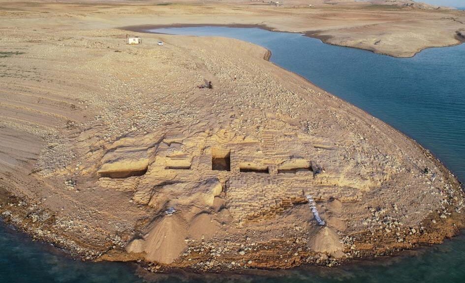
After the waters in the Mosul Dam reservoir have receded, researchers said they’ve uncovered “one of the most important archaeological discoveries in the region.” According to researchers, the Mittani Kingdom is one of the least understood ancient civilizations.
Aerial view of the Kemune Palace from the west. The imposing palace would have once stood just 20 meters from the Tigris River.
A team of German and Kurdish archaeologists found a 3,400-year-old palace belonging to the enigmatic Mittani Empire, which they had found while excavating at the Neolithic settlement of Umm el-Qaab in southern Iraq, the University of Tübingen published on Thursday.
The discovery was only made possible by a drought that significantly reduced water levels in the Mosul Dam reservoir.
“The find is one of the most important archaeological discoveries in the region in recent decades and illustrates the success of the Kurdish-German cooperation,” said Hasan Ahmed Qasim, a Kurdish archaeologist of the Duhok Directorate of Antiquities who worked on the site.
Shrouded in mystery
Last year, the team of archaeologists launched an emergency rescue evacuation of the ruins when receding waters revealed them on the ancient banks of the Tigris. The ruins are part of only a handful discovered from the Mittani Empire.
“The Mittani Empire is one of the least researched empires of the Ancient Near East,” said archaeologist Ivana Puljiz of the University of Tübingen. “Even the capital of the Mittani Empire has not been identified.”
Terrace wall on the western side of Kemune Palace.
Mural fragment discovered in Kemune Palace.
‘Archaeological sensation’
The team had little time to spare as water levels continued to rise, eventually submerging the ruins again. At least 10 cuneiforms clay tablets were discovered inside the palace.
“We also found remains of wall paints in bright shades of red and blue,” Puljiz said. “In the second millennium BCE, murals were probably a typical feature of palaces in the Ancient Near East, but we rarely find them preserved. Discovering wall paintings in Kemune is an archaeological sensation.”
A team of researchers in Germany will now try to interpret the cuneiform tablets.
They hope that the clay tablets will reveal more about the Mittani Empire, which once dominated life in parts of Syria and northern Mesopotamia.
Massive Ancient City Containing Huge Pyramid Unearthed in China
Archaeologists have discovered the remains of an ancient lost city in China where human sacrifice was practised. The Neolithic site known as Shimao, in present-day Shaanxi province, was once thought to be an unexcavated part of the Great Wall of China.
The pyramid was decorated with eye symbols and “anthropomorphic,” or part-human, part-animal faces.
Those figures “may have endowed the stepped pyramid with special religious power and further strengthened the general visual impression on its large audience,” the archaeologists wrote in the article.
This figure shows images of the step pyramid. a) part of the stone buttresses of the second and the third steps of the pyramid; b) eye symbols that decorate the pyramid c) a view of the buttresses under excavation; d) a general view of the pyramid before excavation.
For five centuries, a city flourished around the pyramid. At one time, the city encompassed an area of 988 acres (400 hectares), making it one of the largest in the world, the archaeologists wrote. Today, the ruins of the city are called “Shimao,” but its name in ancient times is unknown.
The pyramid contains 11 steps, each of which was lined with stone. On the topmost step, there “were extensive palaces built of rammed earth, with wooden pillars and roofing tiles, a gigantic water reservoir, and domestic remains related to daily life,” the researchers wrote.
The city’s rulers lived in these palaces, and art and craft production were carried out nearby. “Evidence so far suggests that the stepped pyramid complex functioned not only as a residential space for ruling Shimao elites but also as a space for artisanal or industrial craft production,” the archaeologists wrote.
A sacrificial pit of human skulls discovered at Shimao. The people sacrificed may have been captives captured in war. This photo was first published in 2016 in an article in the Chinese language journal Kaogu yu wenwu.
A series of stone walls with ramparts and gates was built around the pyramid and the city. “At the entrance to the stepped pyramid were sophisticated bulwarks [defensive walls] whose design suggests that they were intended to provide both defense and highly restricted access,” the archaeologists wrote.
The remains of numerous human sacrifices have been discovered at Shimao. “In the outer gateway of the eastern gate on the outer rampart alone, six pits containing decapitated human heads have been found,” the archaeologists wrote.
Some of the victims may be from another archaeological site called Zhukaigou, which is located to the north of Shimao, and the people of Shimao may have conquered the neighbouring site.
“Morphological analysis of the human remains suggests that the victims may have been related to the residents of Zhukaigou, which could further suggest that they were taken to Shimao as captives during the expansion of the Shimao polity,” the study said.
Additionally, jade artefacts were inserted into spaces between the blocks in all of Shimao’s structures. “The jade objects and human sacrifice may have imbued the very walls of Shimao with ritual and religious potency,” the archaeologists wrote.
While archaeologists have known about Shimao for many years, it was once thought to be part of the Great Wall of China, a section of which is located nearby.
It wasn’t until excavations were carried out in recent years that archaeologists realized that Shimao is far older than the Great Wall, which was built between 2,700 and 400 years ago.
The pyramid and the surrounding area were fortified with ramparts
The team of archaeologists that wrote the article includes Li Jaang, a professor at the School of History at Zhengzhou University; Zhouyong Sun and Jing Shao, who are both archaeologists at the Shaanxi Provincial Institute of Archaeology; and Min Li, an anthropology professor at UCLA.
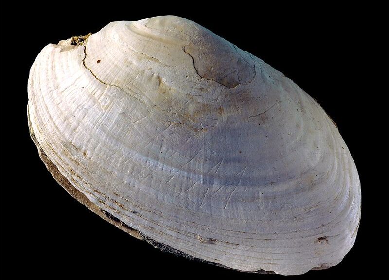
World’s Oldest Art Identified in Half-Million-Year-Old Zigzag
About half a million years ago, early homo Erectus on java was already using freshwater mussel shells as weapons and as a “canvas” for engraving. An international team of researchers, led by Leiden archaeologist José Joordens, published this discovery Nature.
The discovery provides new insights into the evolution of human behaviour.
Not only Homo sapiens made engravings
“Until this discovery, it was assumed that comparable engravings were only made by modern humans (Homo sapiens) in Africa, starting about 100,000 years ago,” says lead author José Joordens, a researcher at the Faculty of Archaeology at Leiden University.
Scientists found deliberate scratching on a fossil Pseudodon, likely an engraving made by Homo erectus at Trinil in Indonesia.
A team of 21 researchers studied hundreds of fossil shells and associated finds and sediments from the Homo erectus site Trinil, on the Indonesian island of Java.
The shells are part of the Dubois Collection that has been held at the Naturalis Biodiversity Center since the end of the 19th century. The shells were excavated by the Dutch physician and researcher Eugène Dubois, the discoverer of Pithecanthropus erectus — now known as Homo erectus.
Engravings older than weathering
The discovery of an engraved geometrical pattern on one of the shells came as a total surprise. The zig-zag pattern, which can only be seen with oblique lighting, is clearly older than the weathering processes on the shell arising from fossilization.
The study has excluded the possibility that the pattern could have been caused by animals or by natural weathering processes and shows that the ‘zigzag’ pattern is the work of Homo erectus.
Five hundred thousand years old
By applying two dating methods, researchers at the VU University Amsterdam and Wageningen University have determined that the shell with the engraving is minimally 430,000 and maximally 540,000 years old. This means that the engraving is at least four times older than the previously oldest known engravings, found in Africa.
Purpose or meaning of the engraving?
“It’s fantastic that this engraved shell has been discovered in a museum collection where it has been held for more than a hundred years. I can imagine people may be wondering whether this can be seen as a form of early art,” says Wil Roebroeks, Professor of Palaeolithic Archaeology at Leiden University.
Viewed up close, one fossil Pseudodon shell from Java shows evidence of engraving.
See the hole on the inside of this fossil Pseudodon shell? Homo erectus likely bored into the shell at exactly at the spot where the adductor muscle attaches to pop it open.
He was able to finance this long-term research with his NWO Spinoza Prize. “At the moment we have no clue about the meaning or purpose of this engraving.”
Early human-like mussel collector
This research has shown that these early human-like people were very clever about how they opened these large freshwater mussels; they drilled a hole through the shell using a sharp object, possibly a shark’s tooth, exactly at the point where the muscle is attached that keeps the shell closed.
“The precision with which these early humans worked indicates great dexterity and detailed knowledge of mollusc anatomy,” says Frank Wesselingh, a researcher and expert on fossil shells at Naturalis. The molluscs were eaten and the empty shells were used to manufacture tools, such as knives.
Possible follow-on research
This discovery from the historical Dubois collection sheds unexpected new light on the skills and behavior of Homo erectus and indicates that Asia is a promising and, so far, relatively unexplored area for finding intriguing artifacts.
From the Netherlands, researchers at Leiden University, the Naturalis Biodiversity Center, the Vrije Universiteit Amsterdam, the universities of Wageningen and Delft, and the Cultural Heritage Agency of the Netherlands were involved in the research.
This research is being financed by research funding from the NWO Spinoza Prize.
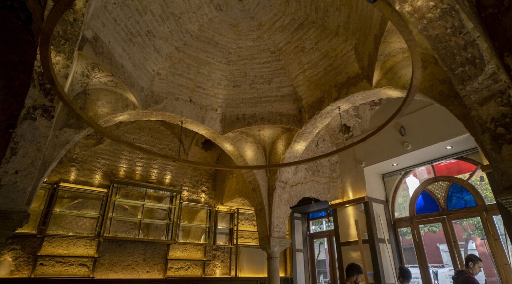
Renovations Reveal Twelfth-Century Bath House in Spain
According to an El País report, renovation of a popular tapas bar on Seville’s Mateos Gago Street revealed the walls and skylights of a twelfth-century hammam, or bathhouse, built during the rule of the Almohad Caliphate.
The 12th-century bathhouse discovered in the popular bar Cervecería Giralda, in Seville.
On Mateos Gago Street, in the southern Spanish city of Seville, the hammam is situated only a few meters from the Roman Catholic cathedral of the city, and for a century it has been one of the most crowded Arab baths in the city. The thing is, customers were not going there to immerse themselves in water, but rather to pour the liquid down their throats: the baths were concealed under a popular bar named Cervecería Giralda.
In the early 1900s, the architect Vicente Traver converted the building into a hotel, thus concealing (and preserving) a bathhouse dating back to the 12th century, during the days of the Almohad Caliphate that ruled Al-Andalus.
The ancient structure emerged again last summer when the bar underwent some renovation work. The work exposed high-quality murals that are unique to Spain and Portugal.
The find came as a big surprise as everyone had previously thought the structure was nothing more than “a Neo-Mudejar pastiche,” in the words of Fran Díaz, the architect in charge of the refurbishment.
Paintings in one of the vaults of the hammam discovered in Seville.
“The most important thing is that we realized the bath was completely painted, from top to bottom, with high-quality geometric decoration,” says Álvaro Jiménez, an archeologist who has supervised the work. “The drawings were made in red ochre on white, and large fragments were preserved on the walls and vaulted ceilings. This is the only surviving Arab bath with an integral decoration; until now, the only known examples had painted just on the baseboards.”
“It’s been a complete surprise. This is an important discovery that gives us an idea of what other baths might have looked like during the Almohad period, especially in Seville, which was one of the two capitals of the empire together with Marrakech,” adds the archeologist Fernando Amores, who collaborated on the project. “The hammam is very near the site of the main mosque, which was also built in the 12th century, and which also explains its much richer decorative elements.”
The first probes under the false ceilings at Giralda – one of the most popular venues in Seville’s historic center – soon unearthed several different kinds of skylights known as luceras. This discovery triggered a completely different approach to the reform work, which began focusing on the complete recovery of the Arab baths.
“Given the relevance of the finds, architecture took a step back and made way for archeology. The solution we found to preserve the baths while allowing the space to keep functioning as a bar was to use a metal cornice to crown the traditional wall tiles put there by Vicente Traver and which are now a part of the establishment’s personality; the original wooden bar counter has also been preserved,” notes Fran Díaz.
The cold room of the hammam at Cervecería Giralda
The 202-square-meter tapas bar, which opened in 1923, will continue in operation when the work ends next month.
The venue’s main space, where the bar counter is located, was once the warm room of the hammam, a space covering 6.70 square meters with an eight-sided vaulted ceiling resting on four columns. One side opens into a rectangular room with a barrel vault that is 4.10 meters wide and 13 meters long, once serving as the bath’s cold room. The kitchen area is where the hot room must have been, although the only remaining vestige is a portion of an arch.
The baths were accessed from Don Remondo street, where the dry area used to be, notes Álvaro Jiménez, who wrote his Ph.D. dissertation on the remains of the Almohad mosque, now the site of Seville’s Roman Catholic cathedral.
The restoration work unveiled 88 skylights in different shapes and sizes, such as stars, lobulated designs, and octagons, that together are much more elaborate than decorations found in other Arab baths from the same period.
Amores also highlights the paintings in the arches of the warm room, made in a zigzagging style meant to represent water. “Nearly all the representations in the Islamic world allude to paradise,” he notes.
The uniqueness of this bath does not rest solely on its latticed paintings, but also on the five rows of skylights in the cold room – other baths have three, and sometimes just one. The cold room, which for the last century has served as the bar’s eating area, lost two meters in 1928 when Mateos Gago street was widened.
A geometric design above the door leading to the cold room of the baths.
In order to understand the structure of the baths, which were typically built by the state and handed over to third parties for management, an expert named Margarita de Alba used photogrammetry techniques to recreate what these spaces must have looked like in the 12th century when Seville was known as Isbilia.
“There is documentary evidence in Christian texts from 1281 about the so-called baths of García Jofre, described as adjoining a property given by King Alfonso X to the Church of Seville. The next testimony is from the 17th-century historian Rodrigo Caro, who said that the vault you see when you enter from Borceguinería [the earlier name for Mateos Gago street] is not a bath, writing: ‘I’d sooner believe these are relics from some circus or amphitheater.’
Even the art historian José Gestoso said the vault is ‘of Mauritanian tradition, a construction that is frequently seen in Seville monuments from the 15th and 16th centuries,” says Jiménez, illustrating how popular belief held that the García Jofre bath had disappeared due to the passage of time.
But it was there the whole time. In the 17th century, there was a major reform that took down the vault in the warm room and rebuilt a much lower one to make room for an extra floor above it. “The building was ‘Italianized’ and the original columns, probably made from reused Roman columns, were replaced with others made with Genoese marble. All the skylights were shut. Our theory is that it became the premises for a merchant who built his home over the shop,” adds Jiménez.
The 20th-century architect Vicente Traver could have torn down the remains of the bathhouse, but he chose to protect and preserve them. And now, customers of Cervecería Giralda know that they are having their beers inside an Almohad hammam.