How DNA has shed light on the Irish pharaoh and his ancient tomb builders
A team of Irish geneticists and archaeologists reported that a man whose cremated remains were interred at the heart of Newgrange was the product of a first-degree incestuous union, either between parent and child or brother and sister.

The finding, combined with other genetic and archaeological evidence, suggests that the people who built these mounds lived in a hierarchical society with a ruling elite that considered themselves so close to divine that, like the Egyptian pharaohs, they could break the ultimate taboos.
In Ireland, more than 5,000 years ago people farmed and raised cattle. But they were also moved, like their contemporaries throughout Europe, to create stunning monuments to the dead, some with precise astronomical orientations.
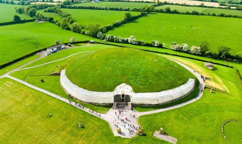
Stonehenge, a later megalith in the same broad tradition as Newgrange, is famous for its alignment to the summer and winter solstice. The central underground room at Newgrange is built so that as the sun rises around the time of the winter solstice it illuminates the whole chamber through what is called a roof box.
Archaeologists have long wondered what kind of society built such a structure, which they think must have had a ritual or spiritual significance. If, as the new findings indicate, it was a society that honoured the product of an incestuous union by interring his remains at the most sacred spot in a sacred place, then the ancient Irish may well have had a ruling religious hierarchy, perhaps similar to those in ancient societies in Egypt, Peru, and Hawaii, which also allowed marriages between brother and sister.
In a broad survey of ancient DNA from bone samples previously collected at Irish burial sites thousands of years old, the researchers also found genetic connections among people interred in other Irish passage tombs, named for their underground chambers or passages. That suggests that the ruling elite were related to one another.
Daniel G Bradley, of Trinity College, Dublin, a specialist in ancient DNA who led the team with Lara M Cassidy, a specialist in population genetics and Irish prehistory also at Trinity College, said the genome of the man who was a product of incest was a complete surprise. They and their colleagues reported their findings in the journal Nature.
Newgrange is part of a necropolis called Bru na Boinne, or the palace of the Boyne, dating to around 5,000 years ago that includes three large passage tombs and many other monuments. It is one of the most remarkable of Neolithic monumental sites in all of Europe.
Of the site’s tombs, Bradley said, “Newgrange is the apogee.” It is not just that it incorporates 200,000 tons of earth and stone, some brought from kilometers away. It also has a precise orientation to the winter sun.
On any day, “when you go into the chamber, it’s a sort of numinous space, it’s a liminal space, a place that inspires a sort of awe,” Bradley said.
That a bone recovered from this spot produced such a genomic shocker seemed beyond coincidence. This had to be a prominent person, the researchers reasoned. He wasn’t placed there by accident, and his parentage was unlikely to be an accident. “Whole chunks of the genome that he inherited from his mother and father, whole chunks of those were just identical,” Bradley said. The conclusion was unavoidable: “It’s a pharaoh, I said. It’s an Irish pharaoh.”
David Reich of Harvard University, one of the ancient DNA specialists who has tracked the grand sweep of prehistoric human migration around the globe, and was not involved in the research, called the journal article “amazing.”
“I think it’s part of the wave of the future about how ancient DNA will shed light on social structure, which is really one of its most exciting promises,” he said, although he had some reservations about evidence that the elite was genetically separate from the common people, a kind of royal family.
Bettina Schulz Paulsson, a prehistoric archaeologist at the University of Gothenburg in Sweden, said the researchers’ finding that suggested a religious hierarchy was a “very attractive hypothesis.”
The paper is rich with other detail, including the discovery that an infant had Down syndrome. The authors believe this is the oldest record of Down syndrome. Chemical tests of the bone also showed that the infant had been breastfed and that he was placed in an important tomb. Both of those facts suggest that he was well cared for, in keeping with numerous other archaeological finds of children and adults with illnesses or disabilities who were supported by their cultures.
Cassidy said they also found DNA in other remains that indicated relatives of the man who was a child of royal incest were placed in other significant tombs. “This man seemed to form a distinct genetic cluster with other individuals from passage tombs across the island,” she said.
She said “we also found a few direct kinship links,” ancient genomes of individuals who were distant cousins. That contributed to the idea that there was an elite who directed the building of the mounds. In that context, it made sense that the incest was intentional. That’s not something that can be proved, of course, but other societies have encouraged brother-sister incest.
“The few examples where it is socially accepted,” she said, are “extremely stratified societies with an elite class who are able to break rules.”