Category Archives: AFRICA

The mummified ‘giant finger’ of Egypt: Did giants once really roam on Earth?

The mummified ‘giant finger’ of Egypt: Did giants once really roam on Earth?

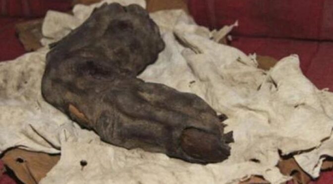
A 15-inch long human finger has been found in Egypt and pictures of it are being released for the very first time.  BILD.de broke this story, and it is spreading like fire all over the Internet. 

According to BILD.de, the pictures of this finger were taken by a researcher named Gregor Spörri in Egypt in 1988.  The mummified finger would be considered to be human except for the fact that it is way, way too large to have come from a human hand. 

As mentioned earlier, the giant finger is 15 inches long.  It is projected that the person that this finger came from would have been more than 16 feet tall!  You can see more pictures of this amazing find on BILD.de.


Could this be evidence that points towards the existence of giant beings that walked on Earth in the distant past?

As you can tell from the picture above, the fingernail is clearly visible.  This truly is a remarkable specimen.  So is this really a finger of a giant that once lived in Egypt?

Unfortunately, this finger is not housed in a museum in Egypt.  The researcher that took the pictures reportedly had to pay “an old man from a grave robber dynasty” 300 dollars to see it and take pictures of it.

So unfortunately this discovery cannot be independently verified at this time.  Hopefully, all of this publicity will flush this finger back out into the public so that authorities can examine it. 

Certificate of authenticity and X-Ray images of the giant finger

This is potentially an incredibly important part of our history and it would be a shame if these photos are the only evidence we ever get to see of it.

But when it comes to giants, we already know that there is so much other evidence out there.  Recently I wrote about the Nephilim mummy that was found in Peru and about the giant footprints and giant skeletons that have been found all over the world.

But a mummified human finger from a giant in Egypt would be absolutely mind-blowing.  It would be a direct challenge to everything that is commonly accepted about the ancient history of Egypt.

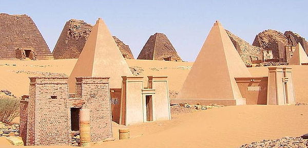
Hopefully, all of this will spur more digs and more research.  The era when the Great Pyramid was constructed in an era that is shrouded in great mystery. 

Humanity is only now developing technology that would allow us to construct a similar structure today.  Nobody really knows for sure who built the Great Pyramid or how it was constructed.

There is just so much about ancient Egypt that we simply do not know.  Hopefully, the floodgates will open and much more evidence will emerge soon.

Ancient wall painting in the Nubian pyramids depicting a Giant carrying two elephants

Ancient wall painting in the Nubian pyramids depicting a Giant carrying two elephants

If you drive north from Khartoum along a narrow desert road toward the ancient city of Meros, a breathtaking view emerges beyond the mirage: dozens of steep pyramids piercing the horizon. No matter how many times you visit, there is an amazing sense of discovery.

The Pyramids of Mero in Bazarwia, Sudan

In Meros itself, once the capital of the Kingdom of Kush, the road divides the city. To the east is the royal cemetery, filled with about 50 sandstone and red brick pyramids of varying heights; The legacy of the European robbers of the 19th century has been broken by many. To the west is the royal city, which includes the ruins of a palace, a temple and a royal bath. 

Each structure has a distinctive architecture that draws on evidence of global ties to the local, Egyptian and Greco-Roman decorative tastes—Mero.

A Brief History of the “Land of Kush”

Aerial view of the Pyramids of Mero

The first settlers in North Sudan date back to 300,000 years ago. It is home to the oldest sub-Saharan African state, the Kingdom of Kush (around 2500–1500 BC). This culture produced some of the most beautiful pottery in the Nile Valley, including the Karma Beaker.

Sudan was reputed for its rich natural resources especially gold, ebony and ivory. Many items in the British Museum collection are made of these materials. 

Ancient Egyptians were drawn south in search of these resources during the Old Kingdom (about 2686–2181 BC), which often led to conflict as Egyptian and Sudanese rulers sought to control trade.

Kush was the most powerful kingdom in the Nile Valley around 1700 BC. The conflict between Egypt and Kush culminated in the conquest of Kush by Thutmose I (1504–1492 BC). In the west and south, Neolithic cultures persisted as both regions were out of reach of the Egyptian rulers.

Peculiar murals of the city of Meros and the giant carrying elephants

The city of Meros is marked by over two hundred pyramids, many of which are in ruins. They have the typical shape and proportions of the Nubian pyramids.

The site of Meros was brought to the knowledge of Europeans in 1821 by the French mineralogist Frédéric Callioud (1787–1869). The most interesting objects were the reliefs and paintings on the walls of the chambers of the tombs. One of the pictures depicts a giant proportion carrying two elephants.

Ancient wall painting in the Nubian pyramids depicting a Giant carrying two elephants
Sudan Meroitic illustration of a Nubian carrying two elephants

His features are not Nubian but Caucasian and his hair is light-coloured. Will this mural be evidence of the existence of a race of red-haired six-fingered demons in ancient times?

In the distant past, did demons really roam the Nile Valley?

In 79 AD, the Roman historian Josephus Flavius ​​wrote that the last race of Egyptian giants lived during the reign of King Joshua in the 79th century BC. He further wrote that they had huge bodies, and their faces were so different from those of ordinary humans that it was wonderful to see them, and it was scary to hear their loud voice which was like the roar of a lion.

In addition, many wall paintings from ancient Egypt depict the builders of the pyramids as “giant people” ranging in size from 5 to 6 meters tall. According to experts, these giants were capable of lifting 4 to 5 tons of blocks separately. 

Some of those ancient murals showed giant kings ruling ancient Egypt, while some depicted comparatively small-sized servants under giants.

In 1988, Gregor Spori, a Swiss entrepreneur and a passionate admirer of ancient Egyptian history, met a gang of robbers of ancient burials through one of the private suppliers in Egypt. 

The meeting took place in a small house in Bir Hooker, a hundred kilometres northeast of Cairo, where Spori saw a giant mummified finger wrapped in rags.

The mummified Egyptian giant finger

The finger was very dry and light. According to Spori, the incredible creature to which he belonged must have been at least 5 meters (about 16.48 feet) in height. To prove authenticity, a Tomb Raider showed a photo of an X-ray of a mummified finger taken in the 1960s.

First Human Traces Buried in an Ancient Gold Mine in Eastern Sahara

First Human Traces Buried in an Ancient Gold Mine in Eastern Sahara

In an ancient gold mine in the Eastern Sahara, some of the earliest evidence of human existence going back 1.8 million years have been unearthed. Archaeologists from the University of Wroclaw discovered a cache of artefacts from the African variety of Homo erectus, the ancestor of humans (Homo sapiens), around 70 kilometres east of Atbara.

Included among the hundreds of artefacts were massive, almond-shaped cleavers resembling fists, weighing several kilograms, and with chipped edges on both sides forming a pointed tip at the junction.

“In the eastern part of Sudan, in the Eastern Desert, like in many places in the Sahara, a gold rush broke out. People were looking for this valuable ore in makeshift, open-cast mines. While exposing subsequent layers, miners came across several-hundred-thousand-year-old tools.”

By examining layers of soil and sand above the objects using the optically stimulated luminescence (OSL) method the archaeologists were able to determine the age of the tools. 

Research project leader Professor Mirosław Masojć from the Institute of Archaeology of the University of Wrocław said: “It turned out that they were about 390,000 years old.

Archaeologists excavated several undisturbed areas within the abandoned gold mine in Sahara and found hundreds of ancient tools.

This means that the layers below are certainly older. Based on the workmanship, I believe that the tools may be over 700,000 years old, perhaps even a million years old, like their counterparts discovered further in the south of Africa.”

Previously, Professor Masojć’s team previously had discovered hand axes and other tools, but never ones that were technologically so close to those from equatorial Africa, or that old. 

It is now thought that in the place where the artefacts were discovered, there used to be a workshop where tools were made because both finished ‘products, as well as flakes formed during their production, have been preserved.

Masojć added that these are the oldest known human creations with such a well-confirmed chronology from Egypt and Sudan. He said: “Ancient tools are found in deserts, but never before have they come from layers that would allow to safely determine their age.”

So far, researchers have found nearly 200 sites where Palaeolithic stone products have been preserved. Some of them are in mines (these are located about 350 km north of Khartoum).

Quartzite unidirectional cores from the mine. Credit: Mirosław Masojć

They find all sorts of tools used by both Homo erectus and Homo sapiens. The age of the tools varies greatly, from over half a million to 60,000 years.

Masojć said it cannot be ruled out that there are even older artefacts in the deeper parts of the mines, but added that accessing them is currently difficult.

He said: “The last research season took place at the end of 2019 when the political situation was very tense, and ultimately there was a coup in Sudan and the long-standing regime was overthrown.

The work was very difficult in terms of logistics: there were fuel shortages, we had to avoid protests, people were dying.”

Researchers from Saudi Arabia, South Korea, Germany and the US were involved in the project financed by the National Science Centre. The research results have just been published in the prestigious journal Plos One

Ancient ostrich eggshell reveals new evidence of extreme climate change thousands of years ago

Ancient ostrich eggshell reveals new evidence of extreme climate change thousands of years ago

Evidence from an ancient eggshell has revealed important new information about the extreme climate change faced by human early ancestors.

The research shows parts of the interior of South Africa that today are dry and sparsely populated, were once wetland and grassland 250,000 to 350,000 years ago, at a key time in human evolution.

Philip Kiberd and Dr Alex Pryor, from the University of Exeter, studied isotopes and the amino acid from ostrich eggshell fragments excavated at the early Middle Stone Age site of Bundu Farm, in the upper Karoo region of the Northern Cape.

It is one of very few archaeological sites dated to 250,000 to 350,000 in southern Africa, a time period associated with the earliest appearance of communities with the genetic signatures of Homo sapiens.

This new research supports other evidence, from fossil animal bones, that past communities in the region lived among grazing herds of wildebeest, zebra, small antelope, hippos, baboons and extinct species of Megalotragus priscus and Equus capensis, and hunted these alongside other carnivores, hyena and lions.

After this period of equitable climate and environment the eggshell evidence — and previous finds from the site — suggests after 200,000 years ago cooler and wetter climates gave way to increasing aridity. A process of changing wet and dry climates recognised as driving the turnover and evolution of species, including Homo sapiens.

The study, published in the South African Archaeological Bulletin, shows that extracting isotopic data from ostrich eggshells, which are commonly found on archaeological sites in southern Africa, is a viable option for open-air sites greater than 200,000 years old.

The technique which involves grinding a small part of the eggshell, to a powder allows experts to analyse and date the shell, which in turn gives a fix on the climate and environment in the past.

Mandible of small antelope in calcrete.

Using eggshells to investigate past climates is possible as ostriches eat the freshest leaves of shrubs and grasses available in their environment, meaning eggshell composition reflects their diet.

As eggs are laid in the breeding season across a short window, the information found in ostrich eggshells provides a picture of the prevailing environment and climate for a precise period in time.

Bundu Farm, where the eggshell was recovered is a remote farm 50km from the nearest small town, sitting within a dry semi-desert environment, which supports a small flock of sheep.

The site was first excavated in the late 1990s the site with material stored at the McGregor Museum, Kimberley (MMK). The study helps fill a gap in our knowledge for this part of South Africa and firmly puts the Bundu Farm site on the map.

Philip Kiberd, who led the study, said: “This part of South Africa is now extremely arid, but thousands of years ago it would have been Eden-like landscape with lakes and rivers and abundant species of flora and fauna.

Our analysis of the ostrich eggshell helps us to better understand the environments in which our ancestors were evolving and provides an important context in which to interpret the behaviours and adaptations of people in the past and how this ultimately led to the evolution of our species.

Excavation of King Khufu’s Second Solar Boat Completed in Egypt

Excavation of King Khufu’s Second Solar Boat Completed in Egypt

Ahram Online reports that the excavation of the second Khufu solar boat discovered in a pit next to the Great Pyramid of Khufu in 1954 has been completed by a joint Japanese and Egyptian team of researchers.

Sakuji Yoshimura, the head of the Egyptian Japanese archaeological mission and president of Higashi Nippon International University, and Professor Emeritus of Waseda University have completed the excavation of the second Khufu Boat from the pit in which it was discovered beside Khufu pyramid in the Giza plateau.

Issa Zidan, the director-general of executive affairs for restoration at the Grand Egyptian Museum and the supervisor of the restoration work of the second Khufu Boat, explained that nearly 1,700 wooden pieces were extracted from 13 layers inside the pit, noting that the registration and documentation of all pieces have been done, as well as the initial restoration of most of these pieces was completed.

Excavation of King Khufu’s Second Solar Boat Completed in Egypt

He also added that, so far, 1,343 pieces were transferred to the Grand Egyptian Museum, where preparations are underway for starting the second phase that includes the final restoration work, as well as conducting the necessary studies for assembling and re-installing the boat that will be displayed next to the first one inside the new building dedicated for King Khufu’s boats, which is now being constructed at the Grand Egyptian Museum.

Omura Yoshifumi, the chief representative of the Japan International Cooperation Agency (JICA) Egypt Office, said that the JICA will provide a $3 million grant for completion of the final restoration work and reassembly of the boat for its display in the museum, in addition to the $2 million grant that was provided in 2013, which supported the excavation and extracting process of the wooden pieces of the boat from the pit.

The project of restoring and extracting the wooden pieces of the second Khufu Boat is one of the largest restoration projects that represent the aspects of fruitful cooperation between Egypt and Japan, with the support of the JICA.

Cooperation between Egyptians and the Japanese in the Grand Egyptian Museum project started in 2006, when the JICA provided financial support through two soft loans of official development assistance for the construction of the museum at the request of the Egyptian government.

Since 2008, the JICA has been providing technical cooperation through the Egyptian Japanese joint conservation project for the restoration, documentation, packaging, and transfer of 72 artefacts — among which were some of King Tutankhamun’s collection — from the Egyptian Museum in Tahrir and other sites to the Grand Egyptian Museum.

About 90 Japanese experts participated in this project, and a number of high-tech technical equipment were provided within the project, such as a digital microscope, a portable X-ray machine, and an electric forklift to carry heavy artefacts safely.

Ambassador Noke expressed his appreciation for the fruitful cooperation with the Ministry of Tourism and Antiquities led by Minister of Tourism and Antiquities Khaled El-Enany and the sincere efforts of Major-General Atef Moftah — the general director of the Grand Egyptian Museum project — and the surrounding area to realise all this progress, stressing that the Grand Egyptian Museum is a symbol of Egyptian Japanese friendship.

From his side, Yoshifumi expressed appreciation for the Egyptian government’s strong leadership in making such great progress in the Grand Egyptian Museum’s construction and related works towards its opening, emphasising that he is proud that the JICA takes part in preserving the world’s treasures in Egypt to the future generations through this project.

Farmer Digs Up Stone Egyptian Stele Saluting Sixth Century BC Pharaoh

Farmer Digs Up Stone Egyptian Stele Saluting Sixth Century BC Pharaoh

A farmer living near Ismailia in Egypt has uncovered a 2,600-year-old stela erected by pharaoh Apries, who ruled from about 589 B.C. to 570 B.C., the Egyptian antiquities ministry reported. 

This stela, dating back about 2,600 years, was found in a farmer’s field near the city of Ismailia in Egypt. It contains 15 lines of hieroglyphic writing.

The farmer found this ancient slab of sandstone while preparing his land for cultivation, about 62 miles (100 kilometres) northeast of Cairo; he then contacted the Tourism and Antiquities Police about the discovery, the ministry statement said.

The stela is 91 inches (230 centimetres) long, 41 inches (103 cm) wide and 18 inches (45 cm) thick. 

At the top of the stela is a carving of a winged sun disk (a disk that was sometimes associated with the sun god Ra) with a cartouche of Pharaoh Apries, with 15 lines of hieroglyphic writing below that, the statement said.

Apries, also known as Wahibre Haaibre, reigned during the 26th dynasty of Egypt (688 B.C. to –525 B.C.), a time when Egypt was independent and its capital was often located at Sais in northern Egypt. 

Efforts are underway to translate the stela.

Mostafa Waziri, secretary-general of the Supreme Council of Antiquities, said that the stela appears to be related to a military campaign that Apries undertook east of Egypt. 

The ancient Greek historian Herodotus (lived ca. 484-425 B.C.) claimed that Apries fought a losing war against the Phoenicians that left many Egyptian soldiers dead and sparked a civil war in Egypt that ultimately led to Apries being killed and replaced as pharaoh by a man named Amasis. Whether this stela will shed new light on these events is unclear. 

Dozens of ancient pyramids found at a single site in Sudan

Dozens of ancient pyramids found at a single site in Sudan

Among the discoveries are pyramids with a circle built inside them, cross-braces connecting the circle to the corners of the pyramid. Outside of Sedeinga only one pyramid is known to have been built in this way.

At least 35 small pyramids, along with graves, have been discovered clustered closely together at a site called Sedeinga in Sudan. Discovered between 2009 and 2012, researchers are surprised at how densely the pyramids are concentrated.

In one field season alone, in 2011, the research team discovered 13 pyramids packed into roughly 5,381 square feet (500 square meters), or slightly larger than an NBA basketball court. They date back around 2,000 years to a time when a kingdom named Kush flourished in Sudan. Kush shared a border with Egypt and, later on, the Roman Empire.

The desire of the kingdom’s people to build pyramids was apparently influenced by Egyptian funerary architecture.

At Sedeinga, researchers say, pyramid building continued for centuries. “The density of the pyramids is huge,” said researcher Vincent Francigny, a research associate with the American Museum of Natural History in New York, in an interview with LiveScience.

“Because it lasted for hundreds of years they built more, more, more pyramids and after centuries they started to fill all the spaces that were still available in the necropolis.”

This aerial photo shows a series of pyramids and graves that a team of archaeologists has been exploring at Sedeinga in Sudan. Since 2009 they have discovered at least 35 small pyramids at the site, the largest being 22 feet (7 meters) in width.

The biggest pyramids they discovered are about 22 feet (7 meters) wide at their base with the smallest example, likely constructed for the burial of a child, being only 30 inches (750 millimetres) long.

The tops of the pyramids are not attached, as the passage of time and the presence of a camel caravan route resulted in damage to the monuments. Francigny said that the tops would have been decorated with a capstone depicting either a bird or a lotus flower on top of a solar orb.

The building continued until, eventually, they ran out of room to build pyramids. “They reached a point where it was so filled with people and graves that they had to reuse the oldest one,” Francigny said.

Francigny is excavation director of the French Archaeological Mission to Sedeinga, the team that made the discoveries. He and team leader Claude Rilly published an article detailing the results of their 2011 field season in the most recent edition of the journal Sudan and Nubia.

The inner-circle

Among the discoveries were several pyramids designed with an inner cupola (circular structure) connected to the pyramid corners through cross-braces. Rilly and Francigny noted in their paper that the pyramid design resembles a “French Formal Garden.”

Only one pyramid, outside of Sedeinga, is known to have been constructed this way, and it’s a mystery why the people of Sedeinga were fond of the design. It “did not add either to the solidity or to the external aspect [appearance] of the monument,” Rilly and Francigny write.

A discovery made in 2012 may provide a clue, Francigny said in the interview. “What we found this year is very intriguing,” he said.

“A grave of a child and it was covered by only a kind of circle, almost complete, of brick.” It’s possible, he said, that when pyramid building came into fashion at Sedeinga it was combined with a local circle-building tradition called tumulus construction, resulting in pyramids with circles within them.

People were buried beside the pyramids in tomb chambers that often held more than one individual. This image shows a child who was buried with necklaces.

An offering for grandma?

The graves beside the pyramids had largely been plundered, possibly in antiquity, by the time archaeologists excavated them. Researchers did find skeletal remains and, in some cases, artefacts. 

One of the most interesting new finds was an offering table found by the remains of a pyramid. . It appears to depict the goddess Isis and the jackal-headed god Anubis and includes an inscription, written in Meroitic language, dedicated to a woman named “Aba-la,” which may be a nickname for “grandmother,” Rilly writes.

It reads in translation:

Oh, Isis! Oh Osiris!

It is Aba-la.

Make her drink plentiful water;

Make her eat plentiful bread;

Make her be served a good meal.

The offering table with the inscription was a final send-off for a woman, possibly a grandmother, given a pyramid burial nearly 2,000 years ago.

Atlantis found in west Africa the evidence is overwhelming

Atlantis found in west Africa the evidence is overwhelming

You have to give credit to the amateur archaeologist/historian that goes by the name of Bright Insighton YouTube, as he has a knack for assembling highly relevant facts and evidence to demonstrate that history is not always what we think it is or what has been recorded.

He recently crafted, very skillfully I might add, three documentary videos which leave little doubt that the lost city/civilization of Atlantis is not in the places that most have determined it to be, but rather in a seemingly unlikely location – West Africa, or in Mauritania to be precise.

He provides a very thorough list of solid historical, geological, and archaeological evidence that not many experts in these fields can easily deny.

He begins where most historians have – with Plato’s account (the dialogues of the Critias and the Timaeus) which he got from Solon (638 – 558 BC) – a Greek statesman who had visited Sais (in Egypt) around 590 BC and got the information from an Egyptian priest who stressed that it was some 9,000 years old.

Here is one excerpt:

There were alternate zones of sea and land, larger and smaller, encircling one another, there were two of land, and three of water, which were turned as if with a lathe each having its circumference equidistant every way from the centre.

Artlantis found in west Africa the evidence is overwhelming

The image above illustrates this schematic quite well. And the following image was taken of the site – named the Richat Structure, or the “Eye of the Sahara”, in Mauritania:

This is the closest resemblance to the description offered by Plato of any archaeological site that claims to be that of Atlantis. There is no denying it. Even its size is almost precisely the same as Bright Insight describes in his videos.

In addition to the striking similarities between the description of Atlantis in Plato’s account and the site located in the West African nation, there are many topographical attributes that corroborate it.

Although no formal (or at least pubhttps://visitingatlantis.com/george-s-alexander-answers-faq/licly acknowledged) archaeological excavation has taken place at this very remote site, there has been a team that has explored it in situ, namely George S. Alexander and Natalis Rosen from Visiting Atlantis.

Here are a few pictures from the website which show the location and topographical nature of the site:

Map of Mauritania with the ‘RICHAT’ today

There is a lot of additional evidence presented, but there was one in particular that had caught my attention.

An ancient map by the famous historian Herodotus (484 – 425 BC) from around the same time period had an inscription ”ATLANTES ?” labelled on it with the location that appears to be in the same general vicinity as the site of the Richat Structure in Mauritania. Amazing.

I will leave you with Bright Insight’s three videos along with a few additional resources whereby you can form your own judgement and conclusions about whether this is indeed Atlantis.

It will certainly be interesting to see in the years (or decades) to come with more exploration and archaeological work at the site to see what other evidence may corroborate that this is indeed the lost city of Atlantis.

Bright Insight’s three videos:

FIRST: The Lost City of Atlantis – Hidden in Plain Sight – Advanced Ancient Human Civilization
SECOND: This is How We Know Atlantis Existed…AND Where – Lost Ancient Civilization Hidden in Plain Sight (2)
THIRD: Ancient Map PROVES The Lost City of Atlantis is The Eye of The Sahara – Ancient Civilization